Nettetal

Last updated
Nettetal
Krickenbeck Blick vom Park.JPG
Krickenbeck Castle
DEU Nettetal COA.svg
Location of Nettetal within Viersen district
Nettetal in VIE.svgBrüggenKempenSchwalmtal
Germany adm location map.svg
Red pog.svg
Nettetal
North Rhine-Westphalia location map 01.svg
Red pog.svg
Nettetal
Coordinates: 51°19′N6°17′E / 51.317°N 6.283°E / 51.317; 6.283 Coordinates: 51°19′N6°17′E / 51.317°N 6.283°E / 51.317; 6.283
Country Germany
State North Rhine-Westphalia
Admin. region Düsseldorf
District Viersen
Founded1970
Subdivisions6 boroughs
Government
   Mayor (202025) Christian Küsters [1]
Area
  Total84 km2 (32 sq mi)
Elevation
38 m (125 ft)
Population
 (2021-12-31) [2]
  Total42,508
  Density510/km2 (1,300/sq mi)
Time zone UTC+01:00 (CET)
  Summer (DST) UTC+02:00 (CEST)
Postal codes
41334
Dialling codes 02153, 02157, 02158
Vehicle registration VIE, KK
Website www.nettetal.de

Nettetal is a municipality in the district of Viersen, North Rhine-Westphalia, Germany. It is situated in the Lower Rhine region.

Contents

History

Coat of arms DEU Nettetal COA.svg
Coat of arms

Nettetal was founded on January 1, 1970, when the former townships Leuth, Breyell, Hinsbeck and former towns/cities Lobberich and Kaldenkirchen were merged. All five communities had developed around the river Nette.

Nettetal originally contained five boroughs, until Schaag separated from Breyell in 1995, becoming the sixth borough.

At the time of its formation, it was considered too problematic to try and combine all five coats of arms into one, so a new coat of arm was introduced in 1971. It shows a water lily before a blue blackground, symbolizing the predominance of nature and the variety of lakes. Five water lily leaves represent the five founding boroughs of Nettetal.

Demographics

Boroughs of Nettetal Verwaltungsgliederung Nettetal 2011.svg
Boroughs of Nettetal

Nettetal's six boroughs, with populations per its own census, as of December 2020: [3]

BoroughPopulationArea
(km2)
Lobberich 14,06717.64
Kaldenkirchen 10,02515.24
Breyell8,58911.85
Hinsbeck4,63218.98
Schaag3,7416.95
Leuth 1,79613.21
Total Nettetal42,85083.87

Geography

Nettetal is located in the middle of the cross-border Maas-Schwalm-Nette Nature Park, along the border with the Netherlands (the northwest edges of Kaldenkirchen and Leuth touch the border), approximately 20 km (12 mi) north-west of Mönchengladbach, Germany, and 10 km (6.2 mi) south-east of Venlo, Netherlands.

In addition to the river Nette, peat mining from the 16th to the 19th century has resulted in the formation of twelve lakes in the municipality.

The Nette, broad forest, heath areas and lakes make Nettetal a central resort in the Maas-Schwalm-Nette Nature Park.

Lakes

Nettetal features 12 lakes, with a combined area of 179 hectares (440 acres).

Fed by the Nette:

Fed by the Nette's Renne tributary:

Fed by the Nette's Königsbach tributary:

Sights

Krickenbeck Castle (c. 1857 - c. 1883) Schloss Krickenbeck Sammlung Duncker.jpg
Krickenbeck Castle (c.1857 – c.1883)
Kaldenkirchen Sequoia Farm (2010) Sequoiafarm Eingangsbereich.jpg
Kaldenkirchen Sequoia Farm (2010)

Twin towns – sister cities

Nettetal is twinned with: [5]

Notable people

Werner Jaeger 1915 Liebermann Werner Jaeger.jpg
Werner Jaeger 1915

Related Research Articles

<span class="mw-page-title-main">Schwalm (Meuse)</span> River in Germany and the Netherlands

The Schwalm (German) or Swalm (Dutch), is a small river in Germany and the Netherlands, tributary to the river Meuse. Its source is near Wegberg, in the district Heinsberg, south-west of Mönchengladbach, in North Rhine-Westphalia (Germany). The Schwalm flows through Wegberg and Brüggen before flowing into the Meuse across the border with the Netherlands, in Swalmen. Its total length is 45 km.

<span class="mw-page-title-main">Bad Münstereifel</span> Place in North Rhine-Westphalia, Germany

Bad Münstereifel is a historical spa town in the district of Euskirchen, Germany, with about 17,000 inhabitants, situated in the far southwest of the German state of North Rhine-Westphalia. The little town is one of only a few historical towns in the southwest of North Rhine-Westphalia, and because of this is often overcrowded by tourists throughout spring and summer.

<span class="mw-page-title-main">Wegberg</span> Town in North Rhine-Westphalia, Germany

Wegberg is the northernmost town in the district of Heinsberg in North Rhine-Westphalia, Germany.

<span class="mw-page-title-main">Nette (Niers)</span> River in Germany

The Nette is a small river in North Rhine-Westphalia, Germany, a left tributary of the Niers. It rises near Dülken, a borough of Viersen. The Nette flows through Viersen-Boisheim and Nettetal before reaching the Niers in Wachtendonk. Its total length is 28 kilometres (17 mi); its drainage area is 166 km2 (64 sq mi).

<span class="mw-page-title-main">Roetgen</span> Municipality in North Rhine-Westphalia, Germany

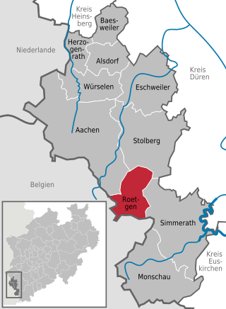
Roetgen is a municipality in the district of Aachen, in North Rhine-Westphalia, Germany.

<span class="mw-page-title-main">Ahaus</span> Town in North Rhine-Westphalia, Germany

Ahaus is a town in the district of Borken in the state of North Rhine-Westphalia, Germany. It is located near the border with the Netherlands, lying some 20 km south-east of Enschede and 15 km south from Gronau. Ahaus is the location of one of Germany's interim storage facilities for radioactive spent fuel.

<span class="mw-page-title-main">Rhede</span> Town in North Rhine-Westphalia, Germany

Rhede is a municipality in the district of Borken in the state of North Rhine-Westphalia, Germany. It is located near the border with the Netherlands, approximately 5 km (3.1 mi) east of Bocholt.

<span class="mw-page-title-main">Südlohn</span> Municipality in North Rhine-Westphalia, Germany

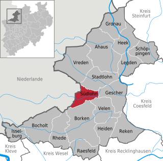
Südlohn is a municipality in the district of Borken in the northwestern part of North Rhine-Westphalia, Germany. It is located right at the border with the Netherlands, approx. 10 km east of Winterswijk. It consists of the villages Südlohn and Oeding.

<span class="mw-page-title-main">Kerken</span> Municipality in North Rhine-Westphalia, Germany

Kerken with the towns of Aldekerk, Eyll, Nieukerk and Stenden, is a municipality in the district of Kleve in the state of North Rhine-Westphalia, Germany. It is located near the border with the Netherlands, approx. 15 km north-east of Venlo.

<span class="mw-page-title-main">Nettersheim</span> Municipality in North Rhine-Westphalia, Germany

Nettersheim is a municipality in the district of Euskirchen in the state of North Rhine-Westphalia, Germany. It is located in the Eifel hills, approx. 20 km south-west of Euskirchen. The rivers Erft and Urft have their source in the municipality.

<span class="mw-page-title-main">Hückelhoven</span> Town in North Rhine-Westphalia, Germany

Hückelhoven is a town in the district of Heinsberg, in North Rhine-Westphalia, Germany. It is situated on the river Rur, approx. 10 km east of Heinsberg, 20 km south-west of Mönchengladbach and approx. 15 km from the border with the Netherlands.

<span class="mw-page-title-main">Wassenberg</span> Town in North Rhine-Westphalia, Germany

Wassenberg is a town in the district Heinsberg, in North Rhine-Westphalia, Germany. It is situated near the border with the Netherlands, on the river Rur, approx. 6 km north-east of Heinsberg and 15 km south-east of Roermond.

<span class="mw-page-title-main">Waldfeucht</span> Municipality in North Rhine-Westphalia, Germany

Waldfeucht is a German municipality in the Heinsberg district, in North Rhine-Westphalia, Federal Republic of Germany. It is situated on the border with the Kingdom of the Netherlands, approx. 15 km south of Roermond and 8 km west of Heinsberg.

<span class="mw-page-title-main">Sundern</span> Town in North Rhine-Westphalia, Germany

Sundern is a town in the Hochsauerland district, in North Rhine-Westphalia, Germany. The name Sundern is common in Westphalia, as it means "ground given away for private usage" in the Westphalian dialect.

<span class="mw-page-title-main">Schieder-Schwalenberg</span> Town in North Rhine-Westphalia, Germany

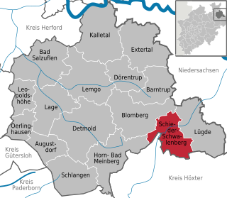
Schieder-Schwalenberg is a town in the Lippe district, in North Rhine-Westphalia, Germany. It is situated approximately 20 km (12 mi) east of Detmold.

<span class="mw-page-title-main">Grevenbroich</span> Town in North Rhine-Westphalia, Germany

Grevenbroich is a town in the Rhein-Kreis Neuss, in North Rhine-Westphalia, Germany. It is situated on the river Erft, approximately 15 km southwest of Neuss and 15 km southeast of Mönchengladbach. Cologne and Düsseldorf are in a 30 km reach. It is notable for having the Frimmersdorf Power Station, which was one of Europe's least carbon-efficient power stations.

<span class="mw-page-title-main">Recke</span> Town in North Rhine-Westphalia, Germany

Recke is a municipality in the district of Steinfurt, in North Rhine-Westphalia, Germany.

<span class="mw-page-title-main">Grefrath</span> Municipality in North Rhine-Westphalia, Germany

Grefrath is a municipality in the district of Viersen, in the western part of North Rhine-Westphalia, Germany.

<span class="mw-page-title-main">Kaldenkirchen Sequoia Farm</span> Arboretum in Lower Rhine region of Germany

The Kaldenkirchen Sequoia Farm is a German arboretum that has been used as a biological institute for many years. Part of the protected area in the city of Nettetal, it is situated in the "Kaldenkirchen Grenzwald". Nettetal lies in the Lower Rhine region of Germany.

<span class="mw-page-title-main">Maas-Schwalm-Nette Nature Park</span> Nature park in North Rhine-Westphalia, Germany

The Maas-Schwalm-Nette Nature Park or NMSM is a cross-border nature park in Germany and the Netherlands, which was founded in 2002. It is a regionally important recreation area.

References

  1. Wahlergebnisse in NRW Kommunalwahlen 2020, Land Nordrhein-Westfalen, accessed 30 June 2021.
  2. "Bevölkerung der Gemeinden Nordrhein-Westfalens am 31. Dezember 2021" (in German). Landesbetrieb Information und Technik NRW . Retrieved 20 June 2022.
  3. "Rathaus | Daten & Fakten | Bevölkerung" [Town Hall | Data and Facts | Population]. Stadt Nettetal (in German). 2020-12-31. Retrieved 2021-02-22.
  4. "Galgenvenn: Deutschlands zweitschönster Wanderweg" [Galgenvenn: Germany's second most beautiful hiking trail]. Westdeutscher Rundfunk (in German). Wandermagazin. 2016-08-11. Archived from the original on 2016-08-28. Retrieved 2021-02-22.
  5. "Städtepartnerschaften". nettetal.de (in German). Nettetal. Retrieved 2021-02-27.