New College Lane

Last updated

The NW end of New College Lane, including the Bridge of Sighs. Bridge of Sighs Oxford 20040124.jpg
The NW end of New College Lane, including the Bridge of Sighs.
Looking into the NW end of New College Lane from its junction with Catte Street. The Beginning of New College Lane from the north.jpg
Looking into the NW end of New College Lane from its junction with Catte Street.
From within the NW end of New College Lane, looking back towards the Bridge of Sighs. New College Lane towards the Bridge of Sighs.jpg
From within the NW end of New College Lane, looking back towards the Bridge of Sighs.
Eastern end of New College Lane near the entrance to New College, with Oxford University undergraduates in academic dress. Oxford University students academic dress.jpg
Eastern end of New College Lane near the entrance to New College, with Oxford University undergraduates in academic dress.
New College Lane, just past the entrance to New College, looking south west towards All Souls College. All souls from new college lane.jpg
New College Lane, just past the entrance to New College, looking south west towards All Souls College.

New College Lane is a historic street in central Oxford, England, [1] [2] named after New College, one of the older Oxford colleges, adjacent to the north.

Contents

In 2010, New College Lane was named Britain's fourth most picturesque street, as part of Google's Street View Awards. [3]

Description

At the northwestern end of New College Lane is a junction with Catte Street, with the Sheldonian Theatre opposite. The main feature is the Bridge of Sighs, a covered bridge connecting two parts of Hertford College, which was completed in 1914 and attracts many tourists for the view. Also to the north is a small alley leading past some of the historic city wall to the Turf Tavern, a hidden but favourite public house for students and tourists.

The lane has three bends as it winds its way between the surrounding colleges. There is a rear entrance to New College. The lane is largely surrounded by high stone walls, with few windows. Some good examples of gargoyles can be seen, a feature of Oxford college architecture.

At its southeastern end, the lane continues as Queen's Lane, named after Queen's College to the south and west. There is a gate in the road at this point to prevent through traffic.

Historic Markers

A plaque on a terraced house on the north side of the lane records that it was occupied by Edmond Halley, after whom Halley's Comet is named.

Residents

Past and present residents of the lane include:

Local Legends

Local legend claims that, during the English Civil War, Prince Rupert gathered volunteers here for an unsuccessful mounted raid on a Parliamentarian pay train. The reports of the sound of clattering hooves and men in armour here have been linked to this legend via Stone Tape theory. [4] A phantom horse and carriage was reported here by Isis on 5 June 1968. [5]

Related Research Articles

<span class="mw-page-title-main">Turl Street</span> Street in central Oxford, England

Turl Street is a historic street in central Oxford, England.

<span class="mw-page-title-main">High Street, Oxford</span> Street in Oxford, England

The High Street in Oxford, England, known locally as the High, runs between Carfax, generally seen as the centre of the city, and Magdalen Bridge to the east.

<span class="mw-page-title-main">Broad Street, Oxford</span> Street in central Oxford, England

Broad Street is a wide street in central Oxford, England, just north of the former city wall. The street is known for its bookshops, including the original Blackwell's bookshop at number 50, located here due to the University of Oxford. Among residents, the street is traditionally known as The Broad.

<span class="mw-page-title-main">Holywell Street, Oxford</span> Street in central Oxford, England

Holywell Street is a street in central Oxford, England. It runs east–west with Broad Street to the west and Longwall Street to the east. About halfway along, Mansfield Road adjoins to the north.

<span class="mw-page-title-main">St Aldate's, Oxford</span> Street in central Oxford, England

St Aldate's is a street in central Oxford, England, named after Saint Aldate, but formerly known as Fish Street.

<span class="mw-page-title-main">Bevington Road</span> Residential road in North Oxford, England

Bevington Road is a residential road in central North Oxford, England.

<span class="mw-page-title-main">Winchester Road, Oxford</span> Road in North Oxford, England

Winchester Road is a road in North Oxford, England. It runs north–south between and roughly parallel with Woodstock Road to the west and Banbury Road to the east. It is in a desirable area with high house prices.

<span class="mw-page-title-main">Catte Street</span> Street in central Oxford, England

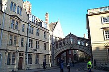
Catte Street is a historic street in central Oxford, England.

<span class="mw-page-title-main">Kingston Road, Oxford</span> Road in Oxford, England

Kingston Road is a road in Oxford, England. It continues north from Walton Street, at the junction with Walton Well Road to the west and St Bernard's Road to the east, running parallel with and to the west of Woodstock Road. Kingston Road is the main road in Walton Manor. At the northern end, there is a staggered junction with Aristotle Lane to the west and Polstead Road to the east. The road continues as Hayfield Road. Southmoor Road and Southmoor Place lead off Kingston Road to the west.

<span class="mw-page-title-main">Brasenose Lane</span> Lane in central Oxford, England

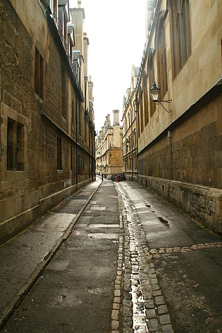
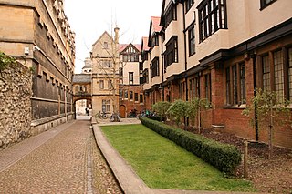
Brasenose Lane runs east–west in central Oxford, England, between Turl Street and Radcliffe Square respectively. From Turl Street it is only accessible to pedestrians, but vehicles can enter from Radcliffe Square. The lane retains the medieval pattern of a single drainage channel in its centre and has high stone-faced college buildings on each side, being flanked by three historic Oxford colleges.

<span class="mw-page-title-main">St Michael's Street, Oxford</span> Street in central Oxford, England

St Michael's Street is a street in central Oxford, England. It runs between New Inn Hall Street to the west and Cornmarket to the east, with Ship Street almost opposite.

<span class="mw-page-title-main">Mansfield Road, Oxford</span> Road in central Oxford, England

Mansfield Road is a road in central Oxford, England. It runs north-south with two of Oxford University's colleges on it, Mansfield College and Harris Manchester College, and Queen Elizabeth House which houses the Oxford Department of International Development.

<span class="mw-page-title-main">Oxpens Road</span>

Oxpens Road is a road in central Oxford, England, linking west and south Oxford. It is named after the marshy area of Oxpens, next to one of the branches of the River Thames in Oxford. It forms part of the A420 road.

<span class="mw-page-title-main">Hythe Bridge Street</span> Street in central Oxford, England

Hythe Bridge Street is in the west of central Oxford, England, forming part of the A4144 road.

<span class="mw-page-title-main">Harry Wilkinson Moore</span>

Harry Wilkinson Moore, FRIBA (1850–1915) was a Victorian and Edwardian architect. He was the son of Arthur Moore (1814–1873) and Mary Wilkinson (1821–1904), and a nephew of the architects George Wilkinson and William Wilkinson.

<span class="mw-page-title-main">Pullens Lane</span> Road in Headington, east Oxford, England

Pullens Lane is in Headington, east Oxford, England. It is located at the top of Headington Hill, leading north off Headington Road to Jack Straw's Lane and Harberton Mead. The cul-de-sac Pullens Field leads off west from Pullens Lane.

<span class="mw-page-title-main">New Road, Oxford</span> Street in west central Oxford, England

New Road is a street in west central Oxford, England. It links Park End Street and Worcester Street to the west with Queen Street and Castle Street to the east. To the south is Oxford Castle and the former Oxford Prison, now a Malmaison hotel. To the north is Nuffield College, a graduate college of Oxford University. At the eastern end on the south side is New County Hall, the headquarters of Oxfordshire County Council.

<span class="mw-page-title-main">Brewer Street, Oxford</span> Street in central Oxford, London

Brewer Street is a historic narrow street in central Oxford, England, south of Carfax. The street runs east–west, connecting with St Aldate's to the east and St Ebbe's Street to the west.

<span class="mw-page-title-main">Rewley Road</span>

Rewley Road is in the west of central Oxford, England. It is located in St Thomas's parish.

<span class="mw-page-title-main">Edmond Halley</span> English astronomer, geophysicist, mathematician, meteorologist, and physicist

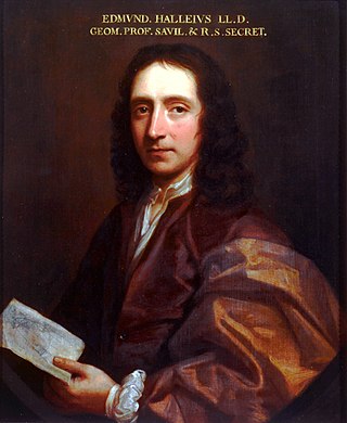
EdmondHalley was an English astronomer, mathematician and physicist. He was the second Astronomer Royal in Britain, succeeding John Flamsteed in 1720.

References

  1. Sherwood, Jennifer; Pevsner, Nikolaus (1974). The Buildings of England: Oxfordshire. Penguin Books. pp. 140, 141, 166, 172–173, 329. ISBN   0-14-071045-0.
  2. Tyack, Geoffrey (1998). Oxford: An architectural guide. Oxford University Press. pp. 41, 42, 106, 275, 276. ISBN   0-14-071045-0.
  3. "Announcing Winners of Google Street View Awards" . Retrieved 28 March 2010.
  4. Andrews, Ross (2010). "Ghost Walk - The Free One". Paranormal Oxford. Chalford, Gloucestershire: Amberley. pp. 29–31. ISBN   978-1-4456-0002-4.
  5. Yurdan, Marilyn (2002). "Oxford City and University". Unexplained Oxford and Oxfordshire. Dunstable, Bedfordshire: The Book Castle. p. 20. ISBN   978-1-9037-4721-6.

51°45′16″N1°15′12″W / 51.75444°N 1.25333°W / 51.75444; -1.25333