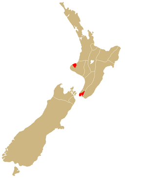
New Plymouth (Māori: Ngāmotu) is the major city of the Taranaki region on the west coast of the North Island of New Zealand. It is named after the English city of Plymouth, in Devon, from where the first English settlers to New Plymouth migrated. The New Plymouth District, which includes New Plymouth City and several smaller towns, is the 10th largest district (out of 67) in New Zealand, and has a population of 88,900 – about two-thirds of the total population of the Taranaki Region and 1.7% of New Zealand's population. This includes New Plymouth City (59,600), Waitara (7,550), Inglewood (3,870), Ōakura (1,730), Ōkato (561) and Urenui (429).[2]
The city itself is a service centre for the region's principal economic activities, including intensive pastoral activities (mainly dairy farming) as well as oil, natural gas and petrochemical exploration and production. It is also the region's financial centre as the home of the TSB Bank (formerly the Taranaki Savings Bank), the largest of the remaining non-government New Zealand-owned banks.
New Plymouth was awarded the most liveable city (for a population between 75,000–150,000) by the International Awards for Liveable Communities in 2021. In 2023, New Plymouth was awarded New Zealand's most beautiful small city by Keep New Zealand Beautiful.[3] It also won multiple awards in 2008. The city was in 2010 chosen as one of two walking & cycling "Model Communities" by the government. Based on New Plymouth's already positive attitude towards cyclists and pedestrians, the city received $3.71m to invest into infrastructure and community programmes to boost walking and cycling.[4]
The area where New Plymouth was founded had for centuries been the home for several Māoriiwi (tribes). From about 1823, the Māori began having contact with European whalers as well as traders who arrived by schooner to buy flax.[5]
In 1828 Richard "Dicky" Barrett (1807–47) set up a trading post at Ngāmotu after arriving on the trading vessel Adventure. Barrett traded with the local Māori and helped negotiate the purchase of land from them on behalf of the New Zealand Company. Settlers were selected by the Plymouth Company, which was set up to attract emigrants from the West Country of England, and which took over land initially purchased by the New Zealand Company. The grid plan for the town's streets was laid out by surveyor Frederic Carrington.[6] The first of the town's settlers arrived on the William Bryan, which anchored off the coast on 31 March 1841. A series of disputes over ownership and settlement of land developed between Māori and settlers soon after and New Plymouth became a fortified garrison town in 1860–1861 as more than 3500 Imperial soldiers, as well as local volunteers and militia, fought Māori in the First Taranaki War.
New Plymouth has an oceanic climate that could be described as a moist, temperate climate. The average summer afternoon temperature is 21–22°C (70–72°F); the average summer night-time temperature is 12–13°C (54–55°F). The city experiences mild winters, where the average afternoon temperature is 13–14°C (55–57°F) and night-time temperature is 5–6°C (41–43°F). The average annual rainfall is 1,432mm (56.4in). On 15 August 2011 it snowed in New Plymouth, a rare event which has been described as a once in a generation occurrence.[7] A New Plymouth site was named the sunniest in the country in 2021, recording 2592 sunshine hours.[8]
New Plymouth City Council Coat-of-Arms as used from 1949
A Town Board was formed in 1863 and in August 1876, the town was constituted as a borough. Its new status did little to overcome some outside perceptions, however. In 1876, author E. W. Payton wrote that "all the great bustling 'cities' of the colony had a patronising way of trying to snub New Plymouth, referring to it in such derogatory terms as the dullest hole in the colony ... nothing whatever to do there... I find a great liking for this 'slow, old hole' ... it is a quiet, unassuming place and has not done so much to attract immigrants and settlers by exaggerating reports, as some districts have done."[11]
The Fitzroy Town District was merged with New Plymouth borough in August 1911; Vogeltown, Frankleigh Park and Westown were added a year later, followed by St Aubyn-Moturoa. By 1913, the town had a population of 7538. Seafront land was added in 1931 and 1941; land acquired on Omata Rd was added in 1955 and in 1960, large areas including land to the south of Paritutu, as well as Hurdon, Ferndale and Huatoki were included, as well as land straddling Mangorei Rd between the Henui Stream and Waiwakaiho River.
In 1989, as a part of the New Zealand-wide reorganisation of local government, New Plymouth City Council was merged with Taranaki District Council (Taranaki County Council and Waitara Borough merged in 1986), Inglewood District Council (Inglewood Borough and County merged in 1986), and Clifton County Council to form New Plymouth District Council.
Every three years, the Mayor, 14 councillors and 16 community board members are elected by the New Plymouth District's enrolled voters. The full council, sub-committees and standing committees meet on a six-weekly cycle.
The Policy and Monitoring standing committees have delegated authority from the council to make final decisions on certain matters, and they make recommendations to the council on all others. The four community boards–Clifton, Waitara, Inglewood and Kaitake–as well as the subcommittees and working parties can make recommendations to the standing committees for them to consider.
The third standing committee, the Hearings Commission, is a quasi-judicial body that meets whenever a formal hearing is required–for instance, to hear submissions on a publicly notified resource consent application.
The Chief Executive and approximately 460 full-time equivalent staff provide advice and information to the elected members and the public, implement council decisions and manage the district's day-to-day operations.
This includes everything from maintaining more than 280 parks and reserves, waste water management and issuing consents and permits, through to providing libraries and other recreational services and ensuring the district's eateries meet health standards.
New Plymouth District Council's annual operating revenue for 2008/2009 is more than $188million.[12]
New Plymouth's City Ward, which covers 111.33km2 (42.98sqmi),[1] had a population of 57,219 at the 2018 New Zealand census, an increase of 4,347 people (8.2%) since the 2013 census, and an increase of 7,824 people (15.8%) since the 2006 census. There were 22,269 households. There were 27,870 males and 29,346 females, giving a sex ratio of 0.95 males per female. The median age was 40.8 years (compared with 37.4 years nationally), with 11,220 people (19.6%) aged under 15 years, 9,831 (17.2%) aged 15 to 29, 25,251 (44.1%) aged 30 to 64, and 10,917 (19.1%) aged 65 or older.
Ethnicities were 84.9% European/Pākehā, 15.9% Māori, 2.4% Pacific peoples, 6.6% Asian, and 2.2% other ethnicities (totals add to more than 100% since people could identify with multiple ethnicities).
The proportion of people born overseas was 18.1%, compared with 27.1% nationally.
Although some people objected to giving their religion, 50.7% had no religion, 37.3% were Christian, 1.1% were Hindu, 0.7% were Muslim, 0.6% were Buddhist and 2.4% had other religions.
Of those at least 15 years old, 8,880 (19.3%) people had a bachelor or higher degree, and 8,919 (19.4%) people had no formal qualifications. The median income was $30,500, compared with $31,800 nationally. The employment status of those at least 15 was that 21,486 (46.7%) people were employed full-time, 7,098 (15.4%) were part-time, and 1,755 (3.8%) were unemployed.[13]
Industry and utilities
Electric power was first provided in January 1906 from the Mangorei power station alongside the Waiwhakaiho River near Burgess Park.[14] In the 1960s, the New Plymouth Power Station was initially designed to run on coal but constructed to be fuelled by natural gas or fuel oil. This is a thermal power station with a steam turbine, commenced operation in 1974 with units progressively decommissioned from 2000 with one left operating in 2008.[15]
Companies began searching for oil on the New Plymouth coast in 1865 after small deposits of thick oil were found on the shoreline. The first commercial quantities of oil were obtained in January 1866. Exploration continued sporadically, and a refinery opened in 1913. Production ceased about 1972. The city was one of the original nine towns and cities in New Zealand to be supplied with natural gas when the Kapuni gas field in South Taranaki entered production in 1970.[16] The offshore Maui A well began production of natural gas in the late 1970s, sparking a flourishing energy and petrochemical industry. As Maui A's resources decline, new sites in Taranaki are being developed in an effort to find more commercial petrochemical reserves.[17]
Powerco operates the local electricity and natural gas distribution networks in the city.[18] Electricity is supplied from Transpower's national grid at two substations: Carrington Street (Brooklands) and Huirangi. Natural gas is supplied from First Gas's transmission system at a gate station in Bell Block.
Among the city's major industrial companies was Ivon Watkins-Dow, an agricultural chemicals company founded in 1944 by brothers Ivon, Harry and Dan Watkins and joined as a partner 20 years later by Dow Chemicals of Michigan. The company ran a factory at Paritutu making the herbicide 2,4,5-T. A 2005 study found that people who lived close to the Ivon Watkins-Dow plant between 1962 and 1987 were likely to have dioxin levels on average four times higher than the general public. In some groups, the level was as much as seven times as high. A Public Health Medicine senior adviser has claimed that based on international findings, the residents' exposure to dioxin may cause increased rates of disease, in particular cancer. In March 2007, the Ministry of Health announced it would offer a major health support programme to anyone affected.[19][20][21] In April 2008, the Ministry clarified that the programme's main feature would be a free annual medical check up for those who had lived, worked or studied close to the factory.[22]
Features and attractions
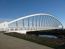
Te Rewa Rewa Bridge which immediately became a symbol of the extensive cycling opportunities that have been created in and around New Plymouth.Coastal Walkway in New PlymouthThe Taranaki Salute to the Anzacs – statue in New Plymouth
New Plymouth District has a reputation as an events centre, with major festivals (the annual TSB Bank Festival of Lights, Taranaki Powerco Garden Spectacular, WOMAD and the biennial Taranaki Arts Festival), sports fixtures (including international rugby, surfing, cricket and tennis matches, and the annual ITU World Cup Triathlon) and concerts (from Sir Elton John, Jack Johnson, REM, John Farnham and Fleetwood Mac).
With its rich volcanic soil, the city is well known for its gardens. Chief among them are the 52ha Pukekura Park in the centre of the city (named a Garden of National Significance), and Pukeiti, a rhododendron garden of international significance high on the Pouakai Range.
Pukekura Park is also the home of the TSB Bank Festival of Lights, which runs for free every year from mid-December to early February. It has daytime and night-time programmes of events for people of all ages, and the festival itself transforms the park into an illuminated wonderland every evening.
Next to the foreshore in the central city is Puke Ariki – the world's first purpose-built, fully integrated museum, library and information centre.[23]
Nearby is the Govett-Brewster Art Gallery, a contemporary art museum. It includes the Len Lye Centre, a purpose-built extension to the museum that houses the collection of filmmaker and kinetic artist Len Lye, which opened in 2015.[24]
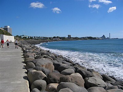
The Coastal Walkway is a 13km path that forms an expansive sea-edge promenade stretching almost the entire length of the city, from the Bell Block mouth in the east to Port Taranaki in the west. The pathway includes the iconic Te Rewa Rewa Bridge and is ideal for walking, running, cycling or skating, or simply enjoying the view of the dramatic west coast.[25] It has won numerous awards, including the Cycle Friendly Award in 2008 for the best New Zealand cycle facility.
Centre City Shopping Centre is the only shopping mall in New Plymouth. It contains over 65 shops and services.[26]
Awards
New Plymouth won the award for the most liveable city (for a population between 75,000-150,000) by the International Awards for Liveable Communities in 2021.[27]
New Plymouth won the Top Town award from North and South Magazine in 2008 (judged "the best place in New Zealand to live, love, work and raise a family").[28]
Whole City Gold award (population category 20,000 – 75,000)
Criteria award for Community Sustainability
Gold award for community project (natural) – the Coastal Walkway.[29][30]
Transport
An 18km (11mi) railway link between New Plymouth and Waitara was completed in 1875; this later became the Waitara Branch. The next year, work began on a line south to Stratford, which was reached in 1879, followed by Hāwera in 1881. This line, known as the Marton - New Plymouth Line, was completed on 23 March 1885, and when the Wellington - Manawatu Line of the Wellington and Manawatu Railway Company was opened on 3 November 1886, a direct railway link was established to Wellington.[31] The original routing through the centre of the town was replaced in 1907 by an alignment along the foreshore, which remains today. The New Plymouth Express passenger train began operating on this route in December 1886. In 1926, it was augmented by the Taranaki Flyer for the run between New Plymouth and Wanganui, A direct railway route to Auckland was not established until 1932, when the Stratford–Okahukura Line was completed; the next year, when the line was handed over from the Public Works Department to the New Zealand Railways Department, the New Plymouth Night Express began operating to Auckland.[32] All carriage trains were replaced by RM classStandard and 88 seaterrailcars by 1956. The Wanganui service ceased in 1959; the Auckland service was truncated to terminate in Taumarunui from 1971; and the Wellington service was cancelled on 30 July 1977. On 11 February 1978, the Taumarunui railcar was replaced by a passenger train, but it was ultimately cancelled on 21 January 1983. Since this date, the only passenger trains to operate to New Plymouth have been infrequent excursions operated by railway preservation societies.[33]
The breakwater at Ngamotu was completed in 1883, providing safe berthage for vessels, and the Moturoa wharf was completed in 1888. Port Taranaki is a critical transport link for the region and the only deep water port on the west coast of New Zealand.
In 1916, the city's electric tramway system began, and petrol-powered buses began running four years later. The tramway system was closed in 1954. It was replaced by trolley buses, which operated until 1967.
The first aircraft landed at the racecourse in 1920 and commercial flights began using the airport at Bell Block in June 1937. During World War II, this grass airfield became RNZAFBell Block; and was replaced in 1966 by the current tarmac airport, 3km (1.9mi) NE of the old airport site.
New Plymouth has two fire stations in the city, with the central station a block away from the CBD. The station houses four fire appliances, including an aerial appliance, along with three specialist vehicles. New Plymouth Central Fire Station is staffed by two crews (8 firefighters) 24 hours a day, 7 days a week and responds, not only to the city, but to surrounding areas if needed. New Plymouth West Volunteer Fire Brigade is based west of the city in the suburb of Spotswood. The volunteer station houses a single appliance, but is close to Port Taranaki and LPG/Gas tanks. The brigade supports New Plymouth and surrounding satellite towns.
Police stations are scattered throughout the city, with the main base at a modern police station on Powderham Street. Other suburban stations are located in Fitzroy, Westown and Bell Block.
St John Ambulance supplies all ambulance services to Taranaki, with their main station based at Taranaki Base Hospital.
Newstalk ZB – local Saturday morning sports show and local break-outs when required for sport and updates
Other stations run by NZME and Mediaworks are broadcast throughout Taranaki but are networked from either Auckland or Wellington.
Local television stations:
7 Taranaki – closed down in 2007
The main television and FM radio transmitter for New Plymouth is located near Tahurangi Lodge on the eastern slopes of Mount Taranaki, 25km (16mi) south of the city. The first transmitter at the site was commissioned in 1966, relaying Wellington's WNTV1 channel (now part of TVNZ 1).[38] Today, digital terrestrial television (Freeview) is available in the city from the Mount Taranaki transmitter.
Notable people
Academia
Zena Daysh (1914–2011), influential in the human ecology movement, founder of the Commonwealth Human Ecology Council
David Gauld (1942–present), president of the New Zealand Mathematical Society 1981–82
Harry Skinner (1886–1978), soldier, ethnologist, university lecturer, museum curator and director, librarian; the H.D. Skinner Annex of the Otago Museum, was opened in August 2013, and named in honour of Skinner
Anthony McCarten (1961–present), author, playwright and screenwriter
John O'Shea (1920–2001), director, producer, writer and actor, produced the only three feature films that were made in New Zealand between 1940 and 1970
Christine Hellyar (1947–present), artist who makes sculptures and installations
Michael Smither (1939–present), painter and composer, set the record for the most expensive painting sold that was painted by a living New Zealand artist
Derryn Hinch (1944–present), Australian media personality, politician, actor, journalist and author, best known for his work on Melbourne radio and television. He served as a Senator for Victoria from 2016 to 2019.
Marama Martin (1930–2017), television and radio broadcaster. She was the first person seen on colour television in New Zealand, and was the last person to appear on NZBC TV
Denzil Meuli (1926–2019), writer, former newspaper editor, Roman Catholic priest of the Diocese of Auckland and a leading traditionalist Catholic in New Zealand
Newton King (1855–1927), auctioneer, merchant and businessman. One of the founders of the Crown Dairy Company. By 1897, it was New Zealand's second-largest dairy product company.
Evelyn Brooke (1879–1962), civilian and military nurse, served during the First World War and was the only New Zealand nurse to receive the Royal Red Cross and Bar
Dame Stella Casey (1924–2000), campaigner for social issues
Te Huirangi Waikerepuru (1929–2020), Māori language activist and trade unionist, was active in the foundation and governance of Māori language radio and television
Andrew Little (1965–present), former leader of the Labour Party (2014–2017), current Member of Parliament (2011–present), current Cabinet Minister (2017–present)
Taranaki is a region in the west of New Zealand's North Island. It is named after its main geographical feature, the stratovolcano Mount Taranaki, also known as Mount Egmont.
Stratford is the only town in Stratford District, and the seat of the Taranaki region, in New Zealand's North Island. It lies beneath the eastern slopes of Mount Taranaki, approximately halfway between New Plymouth and Hāwera, near the geographic centre of the Taranaki Region. The town has a population of 6,320, making it the 62nd largest urban area in New Zealand, and the fourth largest in Taranaki.
The First Taranaki War was an armed conflict over land ownership and sovereignty that took place between Māori and the New Zealand government in the Taranaki district of New Zealand's North Island from March 1860 to March 1861.
Waitara is a town in the northern part of the Taranaki region of the North Island of New Zealand. Waitara is located just off State Highway 3, 15 kilometres (9.3 mi) northeast of New Plymouth.
Ōkato is a small town in rural Taranaki, New Zealand. It is situated about 25 minutes drive around the coast from New Plymouth on State Highway 45. Ōakura is 12 km to the north-east, and Warea is 9 km to the south-west. The place offers popular rocky surfing spots around coastal beaches. The town was established as a military settlement in the 1860s.
Richard Barrett (1807–1847) was one of the first European traders to be based in New Zealand. He lent his translation skills to help negotiate the first land purchases from Maori in New Plymouth and Wellington and became a key figure in the establishment of the settlement of New Plymouth. He was described by Edward Jerningham Wakefield, son of New Zealand Company founder Edward Gibbon Wakefield, as short, stout and "perfectly round all over" and fond of relating "wild adventures and hairbreadth 'scapes".
Te Āti Awa is a Māori iwi with traditional bases in the Taranaki and Wellington regions of New Zealand. Approximately 17,000 people registered their affiliation to Te Āti Awa in 2001, with around 10,000 in Taranaki, 2,000 in Wellington and around 5,000 of unspecified regional location.
Lepperton is a small village in North Taranaki, New Zealand. It is approximately 6 km (3.7 mi) inland from Waitara township, 5 km (3.1 mi) west of the Waitara River, and 1 km (0.62 mi) east of State Highway 3A, which connects Inglewood to Waitara.
The city of New Plymouth, New Zealand, has a history that includes a lengthy occupation and residence by Maori, the arrival of white traders and settlers in the 19th century and warfare that resulted when the demands of the two cultures clashed.
Ōakura is a small township in New Plymouth District, Taranaki, in the western North Island of New Zealand. It is located on State Highway 45, 15 kilometres south-west of New Plymouth. Ōkato is 12 km further south-west. The Oakura River flows past the town and into the North Taranaki Bight. To the south is the Kaitake Range, part of Egmont National Park.
Moturoa is a coastal suburb of New Plymouth, in the western North Island of New Zealand. It is located to the west of the city centre, bordering Port Taranaki and the Sugar Loaf Islands. One of the islands, Moturoa, the largest, shares its name with the suburb.
Tongapōrutu is a settlement in northern Taranaki, in the North Island of New Zealand. It is located on State Highway 3 at the mouth of the Tongaporutu River, 15 kilometres south of Mokau. Tongapōrutu is well known in New Zealand for its 'Three Sisters' rock formations and its Māori petroglyphs carved into cave rock walls. However, both the Māori rock carvings and the 'Three Sisters formations are constantly being eroded by the Tasman Sea.
Awakino is a settlement in the south of Waitomo District, in the North Island of New Zealand. It is located on State Highway 3 at the mouth of the Awakino River, five kilometres north of Mokau. It is 79 km southwest of Te Kūiti, and 98 km northeast of New Plymouth.
The Sugar Loaf Islands are a collection of five small uninhabited islands and several sea stacks near Port Taranaki, New Zealand.
The oil and gas industry in New Zealand explores and develops oil and gas fields, and produces and distributes petroleum products and natural gas.
Puke Ariki is a combined museum and library at New Plymouth, New Zealand which opened in June 2003. It is an amalgamation of the New Plymouth Public Library and the Taranaki Museum. Its name, Māori for "hill of chiefs", is taken from the Māori village that formerly occupied the site.
The Waitara Branch is a 7.245 km long branch line railway in the Taranaki region of New Zealand's North Island. It was built as part of the region's first railway, linking New Plymouth with the closest suitable port, then the river port of Waitara. In 1884 the Breakwater port was opened in New Plymouth, but the line was saved when a (meat) freezing works was opened at Waitara in 1885.
Howard Kevin Tamati, generally known as Howie Tamati, is a New Zealand politician and former professional rugby league footballer and coach who played for New Zealand. He is the cousin of fellow international Kevin Tamati.
Francis Joseph Mace was a Taranaki settler whose exploits during the Taranaki Wars earned him much praise. Chief among his awards was the New Zealand Cross, the highest colonial gallantry award available in New Zealand.
Moturoa is a steeply sloped island off the coast of Taranaki, New Zealand. It is the easternmost and largest of the Sugar Loaf Islands, hence its name, which is Māori for "long island". Moturoa is 120 metres long at its longest point, and around 100 metres wide. It is separated from the Taranaki coast of the North Island mainland by an 800-metre (2,600 ft) wide channel. The entrance to Port Taranaki lies just to the east.
↑ Lambert, Ron (1 September 2016). "Taranaki places - New Plymouth". Te Ara: The Encyclopedia of New Zealand. Archived from the original on 23 September 2023. Retrieved 23 September 2023. Carrington's 1842 map records in detail the topography of the area, and shows the grid he laid out for the town's streets, ignoring the many river valleys. Carrington's tight street grid survived in 21st-century New Plymouth, but made traffic movement through the central city difficult at times.
↑ "International Exchange". List of Affiliation Partners within Prefectures. Council of Local Authorities for International Relations (CLAIR). Archived from the original on 13 January 2016. Retrieved 21 November 2015.
↑ "Sister Cities". New Plymouth District Council. Retrieved 3 April 2018.
Further reading
Churchman, Geoffrey B; Hurst, Tony (2001) [1990, 1991]. The Railways of New Zealand: A Journey through History (Seconded.). Transpress New Zealand. ISBN0-908876-20-3.
This page is based on this Wikipedia article Text is available under the CC BY-SA 4.0 license; additional terms may apply. Images, videos and audio are available under their respective licenses.