
Surrey is a city in British Columbia, Canada. It is located south of the Fraser River on the Canada–United States border. It is a member municipality of the Metro Vancouver regional district and metropolitan area. Mainly a suburban city, Surrey is the province's second-largest by population after Vancouver and the third-largest by area after Abbotsford and Prince George. Seven neighbourhoods in Surrey are designated town centres: Cloverdale, Fleetwood, Guildford, Newton, South Surrey, and City Centre encompassed by Whalley.

Burnaby is a city in the Lower Mainland region of British Columbia, Canada. Located in the centre of the Burrard Peninsula, it neighbours the City of Vancouver to the west, the District of North Vancouver across the confluence of the Burrard Inlet with its Indian Arm to the north, Port Moody and Coquitlam to the east, New Westminster and Surrey across the Fraser River to the southeast, and Richmond on the Lulu Island to the southwest.

The Township of Langley is a district municipality immediately east of the City of Surrey in southwestern British Columbia, Canada. It extends south from the Fraser River to the Canada–United States border, and west of the City of Abbotsford. Langley Township is not to be confused with the City of Langley, which is adjacent to the township but politically is a separate entity. Langley is located in the eastern part of Metro Vancouver.

The Village of Pouce Coupe is a small town in northeastern British Columbia, Canada, and a member municipality of the Peace River Regional District. It was originally named 'Pouskapie's Prairie', after the name of the local native band chief. The 2.06-square-kilometre (0.80 sq mi) municipality is home to 792 residents.
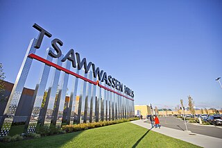
Tsawwassen is a suburban, mostly residential community on a peninsula in the southwestern corner of the City of Delta in British Columbia, Canada. It provides the only road access to the American territory on the southern tip of the peninsula, the community of Point Roberts, Washington, via 56th Street. It is also the location of Tsawwassen Ferry Terminal, part of the BC Ferries, built in 1959 to provide foot-passenger and motor vehicle access from the Lower Mainland to the southern part of Vancouver Island and the southern Gulf Islands. Because Tsawwassen touches a shallow bank, the ferry terminal is built at the southwestern end of a 3 km (1.9 mi) causeway that juts into the Strait of Georgia. Boundary Bay Airport, a major training hub for local and international pilots which also provides local airplane and helicopter service, is ten minutes away. The Roberts Bank Superport is also nearby.

White Rock is a city in British Columbia, Canada, and a member municipality of the Metro Vancouver Regional District. It is bordered by Semiahmoo Bay to the south and is surrounded on three sides by Surrey. To the southeast across a footbridge lies the Semiahmoo First Nation, which is within the borders of Surrey. Semiahmoo Bay and the Southern Gulf Islands in the Strait of Georgia are also to the south.

Greater Vancouver, also known as Metro Vancouver, is the metropolitan area with its major urban centre being the city of Vancouver, British Columbia, Canada. The term "Greater Vancouver" describes an area that is roughly coterminous with the region governed by the Metro Vancouver Regional District (MVRD), though it predates the 1966 creation of the regional district. It is often used to include areas beyond the boundaries of the regional district but does not generally include wilderness and agricultural areas that are included within the MVRD.

The City of Langley, commonly referred to as Langley City, or just Langley, is a municipality in the Metro Vancouver Regional District in British Columbia, Canada. It lies directly east of Surrey, adjacent to the Cloverdale area, and is surrounded elsewhere by the Township of Langley, bordered by its neighbourhoods of Willowbrook to the north, Murrayville to the east, and Brookswood and Fern Ridge to the south.
Edmonton-Highlands-Norwood is a provincial electoral district for the Legislative Assembly of Alberta, Canada. The district was created in 2004 when it was merged with Edmonton-Highlands and Edmonton-Norwood.

Surrey-Whalley is a provincial electoral district for the Legislative Assembly of British Columbia, Canada. The riding's name was resurrected from a former riding in the same area, with similar but not identical boundaries. The newly created riding of Surrey-Whalley kept the majority of the original Surrey-Whalley riding and added a portion of Surrey-Green Timbers.

Surrey-White Rock is a provincial electoral district for the Legislative Assembly of British Columbia, Canada. During the 2008 re-distribution of riding boundaries, Surrey-White Rock kept the majority of its existing region.
Cloverdale is a town centre in the city of Surrey, British Columbia, a southeastern suburb of Greater Vancouver, located just west of the City of Langley. The town centre was initially founded as a small farm community in 1870 for its fertile land and temperate climate. Cloverdale eventually amalgamated into Surrey as one of its six town centres.
Whalley is the most densely populated and urban of the six town centres in Surrey, British Columbia, Canada. It encompasses City Centre, the city's central business district, and is home to the Surrey City Hall, the main branch of Surrey Libraries, Central City, SFU Surrey and the site of Kwantlen Polytechnic University's (KPU) Civic Plaza campus. It is the only town centre in Surrey served by Metro Vancouver's SkyTrain rapid transit system. Expo Line stations serving Whalley include Scott Road, Gateway, Surrey Central and King George.

Guildford is a town centre and neighbourhood of Surrey, British Columbia, Canada. It is known for its retail corridors along 104 Avenue and 152 Street. At the intersection of these two streets sits the 200-store Guildford Town Centre. The community is named after Guildford in Surrey, England.

Cortes Island is an island in the Discovery Islands archipelago on the coast of British Columbia, Canada. The island is 25 km (16 mi) long, 13 km (8 mi) wide, and 130 km2 (50 sq mi) in area. It has a population of 1,035 permanent residents. Cortes Island lies within Electoral Area B of the Strathcona Regional District, which provides water and sewage systems, fire protection, land use planning, parks, recreation, and emergency response.
Massey Place, is a geographically localised subdivision of the Confederation Suburban Development Area in the city of Saskatoon, Saskatchewan which is nestled around Archibald McDonald Park. Mcdonald Park is centrally located along the northern perimeter of 33rd Street East. The school yards of both Vincent Massey School and Bishop Klein School have their western boundaries along Archibald McDonald Park which has as its resources ball diamonds, soccer pitches, winter ice rinks, and playground facilities. Massey Place neighbourhood is close to amenities provided by both the commercial district of the Confederation Suburban Centre.

Dundonald is a neighbourhood located in the northwest corner of Saskatoon, Saskatchewan. The neighbourhood was built in the 1980s, and served as the last development of the northwest corner of the city, prior to the development of Hampton Village. Dundonald is surrounded by a large landscaped park, with a storm pond. In comparison, the neighbourhood of Dundonald with a 2001 census population of 5,285 is larger than the Saskatchewan city of Melville which had a population of 4,149 in 2006, and 4,453 in 2001 and Dundonald is also larger than the provincial city of Humboldt which was 4,998 in 2006, and 5,161 in 2001. In Saskatchewan rural towns must maintain a population above 5,000 to apply for city status.
An electoral redistribution was undertaken in 2008 in British Columbia in a process that began in late 2005 and was completed with the passage of the Electoral Districts Act, 2008 on April 10, 2008. The redistribution modified most electoral boundaries in the province and increased the number of MLAs from 79 to 85. The electoral boundaries created by the redistribution were first used in the 2009 provincial election.
Sunnyside is a neighbourhood of South Surrey, which in turn is a region of Surrey, British Columbia, Canada.
An electoral redistribution in British Columbia is underway by the BC Electoral Boundaries Commission. On October 21, 2021, the Government of British Columbia appointed Justice Nitya Iyer, Linda Tynan and Chief Electoral Officer Anton Boegman to serve as the 2021 commissioners. Justice Iyer was appointed the chair.

