North American Water and Power Alliance

Last updated
Map of the NAWAPA project (right), as compared with the GRAND, a continental water management scheme of similar scale ComparisonGCNA-NAWAPA1.gif
Map of the NAWAPA project (right), as compared with the GRAND, a continental water management scheme of similar scale

The North American Water and Power Alliance (NAWPA or NAWAPA, also referred to as NAWAPTA from proposed governing body the North American Water and Power Treaty Authority) was a proposed continental water management scheme conceived in the 1950s by the US Army Corps of Engineers. The planners envisioned diverting water from some rivers in Alaska south through Canada via the Rocky Mountain Trench and other routes to the US and would involve 369 separate construction projects. The water would enter the US in northern Montana. There it would be diverted to the headwaters of rivers such as the Colorado River and the Yellowstone River. Implementation of NAWAPA has not been seriously considered since the 1970s, due to the array of environmental, economic and diplomatic issues raised by the proposal. [1] [2] Western historian William deBuys wrote that "NAWAPA died a victim of its own grandiosity." [2]

Contents

The plan

A technical and economic blueprint for the plan was developed in 1964 by the Parsons Corporation of Pasadena, California. [3] The total cost was estimated in 1975 as $100 billion, comparable in cost to the Interstate Highway System. [4] [5]

Water management

The Parsons plan would divert water from the Yukon, Liard and Peace River systems into the southern half of the Rocky Mountain Trench which would be dammed into a massive, 500 mi (805 km)-long reservoir. Some of the water would be sent east across central Canada to form a navigable waterway connecting Alberta to the Great Lakes with the additional benefit of stabilizing the Great Lakes' water level. The rest of the water would enter the United States in northern Montana, providing additional flow to the Columbia and MissouriMississippi river systems, and would be pumped over the Rocky Mountains via the Sawtooth Lifts in Idaho. From there, it would run south via aqueducts to the Colorado River and Rio Grande systems. Some of this water would be sent around the southern end of the Rockies in New Mexico and pumped north to the High Plains, stabilizing the Ogallala Aquifer. The increased flow of the Colorado River, meanwhile, would enter Mexico, allowing for greater development of agriculture in Baja California and Sonora. [1] [6]

The project would provide 75 million acre feet (93 km3) of water to water-deficient areas in the North American continent, [7] including Canada and the United States, as well as irrigation water for Mexico, which Parsons claimed would receive enough water to reclaim 7 or 8 times more land than Egypt reclaimed with the Aswan High Dam. [8] It would provide increased water flow in the upper Missouri and Mississippi rivers during periods of low flow, increased hydropower generation along the Columbia River, and stabilize water levels in the Great Lakes. [9] Parsons originally proposed using peaceful nuclear explosions to excavate trenches and underground water storage reservoirs for the system. [10]

Power generation

The project would generate a vast amount of electricity from a number of hydroelectric and nuclear power facilities (the latter of which would be required to power the multiple pumping stations needed to move the water across the continent). [1] The issue of electricity generation created some controversy, with some commentators such as Marc Reisner arguing that the plan would be a net consumer of energy, while others estimated a net gain of 60 to 80 million kilowatts after meeting the needs for pumping. [7]

Transportation

The plan would potentially have included a navigable waterway in Canada from Alberta to Lake Superior, to be called the Transcontinental Canal. In addition to increasing availability of water, the canal would address problems of water pollution. [7]

Environmental impacts

The engineering of the project and the creation of a large number of new reservoirs — many of them in designated wilderness areas — would have destroyed vast areas of wildlife habitat in Canada and the American West and would have required the relocation of hundreds of thousands of people — including the entire city of Prince George, British Columbia. [1] A number of federally designated Wild and Scenic Rivers in Idaho and Montana would be submerged under reservoirs, including the Salmon, Lochsa, Clearwater, Yellowstone and Big Hole. [1] The amount of electricity required to pump the water over the Rockies would require the construction of as many as six nuclear power plants. [1] Significant negative consequences were also predicted for Pacific salmon runs in the many Alaskan and Canadian rivers that would be dammed and diverted, reducing their flows. Luna Leopold, a conservationist and professor of hydrology at the University of California, Berkeley said of NAWAPA, "The environmental damage that would be caused by that damned thing can't even be described. It would cause as much harm as all of the dam-building we have done in a hundred years." [1]

Reception

NAWAPA garnered early support from some Western political figures, who viewed its promise of increased water supplies as key to continued growth in the Western United States. In 1966, Congressman Jim Wright, in his book, The Coming Water Famine, wrote that "NAWAPA has an almost limitless potential if we possess the courage and the foresight to grasp it." [11] In 1967, Senator Frank Moss of Utah wrote The Water Crisis, in which he called NAWAPA the most comprehensive water diversion proposal to solve supply and pollution problems. [12] (Moss was later hired by the Parsons Corporation and retained as a lobbyist. [1] ) Los Angeles County Supervisor Mike Antonovich called for Los Angeles to back the plan. The Corps of Engineers studied this project in the 1950s and 1960s, but no official proposal was ever developed. [1] Canadian Prime Minister Lester Pearson was quoted in 1966 saying of the plan that “This can be one of the most important developments in our history." [13]

In the 1970s, the plan began to encounter fierce opposition by a number of different groups on both sides of the border, based on concerns with its financial and environmental costs and the international implications of exporting Canadian water. The environmental movement, which viewed the plan as the "hydrologic anti-Christ," [14] gained momentum in the early 1970s, and is credited with playing a major role in halting the project. [2] [15] After initially expressing support for NAWAPA as Interior Secretary in the 1960s, Stewart Udall publicly ridiculed the plan after leaving office. [1] [16] The project was opposed by public sentiment in Canada, [1] though Canadian financier Simon Reisman, who negotiated the Free Trade Agreement, the precursor to the North American Free Trade Agreement, was one of its backers and main promoters. Nonetheless, the Canadian position on free trade exempted water exports, in part specifically to pre-empt any attempted completion of Reisman's long-time pet project.[ citation needed ] The NAWAPA Foundation, which Parsons had founded to promote the scheme, closed its doors in 1990. [17]

Environmental writer Marc Reisner noted in Cadillac Desert that the plan was one of "brutal magnificence" and "unprecedented destructiveness." [1] Historian Ted Steinberg suggested that NAWAPA summed up "the sheer arrogance and imperial ambitions of the modern hydraulic West" and credited rising costs and the rise of the environmental movement with killing the idea. [15] One author called it "the most outlandish water development scheme to emerge in the past 50 years" [18]

Beginning in 1982, some efforts were made to revive the plan, including by Parsons engineer Roland Kelley, who authored a report called NAWAPA Plan Can Work. [19] The LaRouche movement has supported the project, making efforts to revive NAWAPA in 1982 and again in 2010. [2] [20]

See also

Related Research Articles

Snowy Mountains Scheme Dam in Kosciuszko National Park, New South Wales

The Snowy Mountains scheme or Snowy scheme is a hydroelectricity and irrigation complex in south-east Australia. The Scheme consists of sixteen major dams; nine power stations; two pumping stations; and 225 kilometres (140 mi) of tunnels, pipelines and aqueducts that were constructed between 1949 and 1974. The Scheme was completed under the supervision of Chief Engineer, Sir William Hudson. It is the largest engineering project undertaken in Australia.

South Saskatchewan River

The South Saskatchewan River is a major river in Canada that flows through the provinces of Alberta and Saskatchewan.

Glen Canyon Dam Dam in Coconino County, Arizona

Glen Canyon Dam is a concrete arch-gravity dam on the Colorado River in northern Arizona, United States, near the town of Page. The 710-foot (220 m) high dam was built by the U.S. Bureau of Reclamation (USBR) from 1956 to 1966 and forms Lake Powell, one of the largest man-made reservoirs in the U.S. with a capacity of 27 million acre feet (33 km3). The dam is named for Glen Canyon, a series of deep sandstone gorges now flooded by the reservoir; Lake Powell is named for John Wesley Powell, who in 1869 led the first expedition to traverse the Colorado's Grand Canyon by boat.

California water wars

The California water wars were a series of political conflicts between the city of Los Angeles and farmers and ranchers in the Owens Valley of Eastern California over water rights.

Teton Dam Earth-fill dam, Teton River, Idaho, United States. Catastrophic failure on June 5, 1976

The Teton Dam was an earthen dam on the Teton River in Idaho, United States. It was built by the Bureau of Reclamation, one of eight federal agencies authorized to construct dams. Located in the eastern part of the state, between Fremont and Madison counties, it suffered a catastrophic failure on June 5, 1976, as it was filling for the first time.

Cadillac Desert (1986), is a history by American Marc Reisner about land development and water policy in the western United States. Subtitled The American West and its Disappearing Water, it explores the history of the federal agencies, Bureau of Reclamation and U.S. Army Corps of Engineers, and their struggles to remake the American West in ways to satisfy national settlement goals. The book concludes that the development-driven policies, formed when settling the West was the country's main concern, have had serious long-term negative effects on the environment and water quantity. The book was revised and updated in 1993.

Bow River River in Alberta, Canada

The Bow River is a river in Alberta, Canada. It begins within the Canadian Rocky Mountains and winds through the Alberta foothills onto the prairies, where it meets the Oldman River, the two then forming the South Saskatchewan River. These waters ultimately flow through the Nelson River into Hudson Bay. The Bow River runs through the city of Calgary, taking in the Elbow River at the historic site of Fort Calgary near downtown. The Bow River pathway, developed along the river's banks, is considered a part of Calgary's self-image.

Columbia Basin Project American irrigation project

The Columbia Basin Project in Central Washington, United States, is the irrigation network that the Grand Coulee Dam makes possible. It is the largest water reclamation project in the United States, supplying irrigation water to over 670,000 acres (2,700 km2) of the 1,100,000 acres (4,500 km2) large project area, all of which was originally intended to be supplied and is still classified as irrigable and open for the possible enlargement of the system. Water pumped from the Columbia River is carried over 331 miles (533 km) of main canals, stored in a number of reservoirs, then fed into 1,339 miles (2,155 km) of lateral irrigation canals, and out into 3,500 miles (5,600 km) of drains and wasteways. The Grand Coulee Dam, powerplant, and various other parts of the CBP are operated by the Bureau of Reclamation. There are three irrigation districts in the project area, which operate additional local facilities.

Grand Lake (Colorado)

Grand Lake is Colorado's largest and deepest natural lake. It is located in the headwaters of the Colorado River in Grand County, Colorado. On its north shore is located the historic and eponymous town of Grand Lake. The lake was formed during the Pinedale glaciation, which occurred from 30000 BP to 10000 BP. The glacial terminal moraine created a natural dam. Natural tributaries to the lake are the North Inlet and East Inlet, both of which flow out of Rocky Mountain National Park, which surrounds the lake on three sides. Grand Lake is located 1 mile from the Park's western entrance. Grand Lake was named Spirit Lake by the Ute Tribe because they believed the lake's cold waters to be the dwelling place of departed souls.

California State Water Project Flood control, energy production, and water conveyance infrastructure in California

The California State Water Project, commonly known as the SWP, is a state water management project in the U.S. state of California under the supervision of the California Department of Water Resources. The SWP is one of the largest public water and power utilities in the world, providing drinking water for more than 23 million people and generating an average of 6,500 GWh of hydroelectricity annually. However, as it is the largest single consumer of power in the state itself, it has a net usage of 5,100 GWh.

Robert Moses Niagara Power Plant Dam in Lewiston, New York

The Robert Moses Niagara Hydroelectric Power Station is a hydroelectric power station in Lewiston, New York, near Niagara Falls. Owned and operated by the New York Power Authority (NYPA), the plant diverts water from the Niagara River above Niagara Falls and returns the water into the lower portion of the river near Lake Ontario. It uses 13 generators at an installed capacity of 2,675 MW (3,587,000 hp).

Brazeau River

The Brazeau River is a river in western Alberta, Canada. It is a major tributary of the North Saskatchewan River.

Lake Qaraoun

Lake Qaraoun is an artificial lake or reservoir located in the southern region of the Beqaa Valley, Lebanon. It was created near Qaraoun village in 1959 by building a 61 m-high (200 ft) concrete-faced rockfill dam in the middle reaches of the Litani River. The reservoir has been used for hydropower generation, domestic water supply, and for irrigation of 27,500 ha.

The Kenney Dam is a rock-fill embankment dam on the Nechako River in northwestern British Columbia, built in the early 1950s. The impoundment of water behind the dam forms the Nechako Reservoir, which is also commonly known as the Ootsa Lake Reservoir. The dam was constructed to power an aluminum smelter in Kitimat, British Columbia by Alcan, although in the late 1980s the company increased their economic activity by selling excess electricity across North America. The development of the dam caused various environmental problems along with the displacement of the Cheslatta T'En First Nation, whose traditional land was flooded.

The Central Utah Project is a US federal water project that was authorized for construction under the Colorado River Storage Project Act of April 11, 1956, as a participating project. In general, the Central Utah Project develops a portion of Utah's share of the yield of the Colorado River, as set out in the Colorado River Compact of 1922.

Interbasin transfer

Interbasin transfer or transbasin diversion are terms used to describe man-made conveyance schemes which move water from one river basin where it is available, to another basin where water is less available or could be utilized better for human development. The purpose of such designed schemes can be to alleviate water shortages in the receiving basin, to generate electricity, or both. Rarely, as in the case of the Glory River which diverted water from the Tigris to Euphrates River in modern Iraq, interbasin transfers have been undertaken for political purposes. While ancient water supply examples exist, the first modern developments were undertaken in the 19th century in Australia, India and the United States; large cities such as Denver and Los Angeles would not exist as we know them today without these diversion transfers. Since the 20th century many more similar projects have followed in other countries, including Israel, Canada and China. Utilized alternatively, the Green Revolution in India and hydropower development in Canada could not have been accomplished without such man-made transfers.

Water in California Water supply and distribution in the U.S. state of California

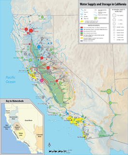
California's interconnected water system serves over 30 million people and irrigates over 5,680,000 acres (2,300,000 ha) of farmland. As the world's largest, most productive, and potentially most controversial water system, it manages over 40 million acre feet (49 km3) of water per year.

Klamath Diversion

The Klamath Diversion was a federal water project proposed by the U.S. Bureau of Reclamation in the 1950s. It would have diverted the Klamath River in Northern California to the more arid central and southern parts of that state. It would relieve irrigation water demand and groundwater overdraft in the Central Valley and boost the water supply for Southern California. Through the latter it would allow for other Southwestern states—Arizona, Nevada, New Mexico and Utah—as well as Mexico to receive an increased share of the waters of the Colorado River.

Hooker Dam was a proposed dam on the Gila River in New Mexico, planned as a major component of the Central Arizona Project. Located near the mouth of the river's canyon upstream from the confluence of the Gila with Mogollon Creek and below Turkey Creek, the dam was to be part of the CAP's Gila River Division, authorized under the 1968 Colorado River Basin Project Act. The project was planned to provide 18,000 acre feet (0.022 km3)/year of water to western New Mexico.

Big Creek Hydroelectric Project

The Big Creek Hydroelectric Project is an extensive hydroelectric power scheme on the upper San Joaquin River system, in the Sierra Nevada of central California. The project is owned and operated by Southern California Edison (SCE). The use and reuse of the waters of the San Joaquin River, its South Fork, and the namesake of the project, Big Creek – over a vertical drop of 6,200 ft (1,900 m) – have over the years inspired a nickname, "The Hardest Working Water in the World".

References

  1. 1 2 3 4 5 6 7 8 9 10 11 12 Reisner, Marc. Cadillac Desert revised edition, 1993
  2. 1 2 3 4 deBuys, William, A Great Aridness:Climate Change and the Future of the American Southwest, Oxford University Press 2011, p. 329
  3. Captured Rain: America's Thirst for Canadian Water, Canadian Broadcasting Corporation, 2000
  4. Barr, L. (1975). NAWAPA: A Continental Water Development Scheme for North America? Geography 60(2), pp.111-119.
  5. Nelson, J.G. and Chambers, M.J., Water, Methuen Publications 1969, p.375
  6. Holm, Wendy (1988). Water and Free Trade: The Mulroney Government's Agenda for Canada's Most Precious Resource. James Lorimer & Company. pp.  31. ISBN   1-55028-166-6.
  7. 1 2 3 Engelbert, Ernest A, and Scheuring, Ann Foley, Water Scarcity: Impacts on Western Agriculture, Berkeley, University of California Press 1984, p. 113
  8. Ebeling, Walter, Fruited Plain: The Story of American Agriculture , Univ of California Press (February 1980), p. 319
  9. Nelson, J.G. and Chambers, M.J., Water, Methuen Publications 1969, p. 371
  10. Forest, B. & Forest, P. (2012). Engineering the North American waterscape: The high modernist mapping of continental water transfer project. Political Geography 31, pp. 167-183.
  11. Wright, Jim, The Coming Water Famine, Coward-McCann (1966), p. 222.
  12. Moss, Frank, The Water Crisis, F. A. Praeger 1967, p. 245.
  13. Congressional Record, Volume 112, Part 5 - Page 6474
  14. Annin, Peter, The Great Lakes Water Wars, Island Press 2006, p. 58
  15. 1 2 Steinberg, T. (2002). Down to Earth: Nature's role in American history.
  16. McCool, Daniel, Command of the waters : iron triangles, federal water development, and Indian water, University of Arizona Press, 1994. p. 108
  17. Guide to North American Water and Power Alliance Records, Archives Center, National Museum of American History
  18. Landry, C., Payne, M. & Root, S. (2012). Grandiose water development plans. Water Resources Impact 14(2). p. 18.
  19. "Kelly, Roland P., NAWAPA Plan Can Work, Energy Report, National Energy Research and Information Institute, La Verne, California, June/July 1982.
  20. Welsh, Francis J., How to Create a Water Crisis, Johnson Books 1985, p. 213