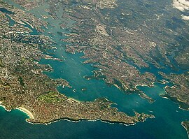
Sydney Harbour with the North Shore extending from its northern side (right) with Sydney CBD (left) and Eastern Suburbs (bottom) on its southern shore.
The term "North Shore", used to describe this region of Sydney is customary, not legal or administrative, and is often subjective.
History
The region now referred to as the North Shore was home to a number a clans of the Eora. These included the Cammeraygal people whose traditional lands were located within what are now the Lower North Shore local government areas of North Sydney, Willoughby, Mosman, Manly and Warringahlocal government areas.[1][2] The Cammeraygal people lived in the area until the 1820s and are recorded as being in the northern parts of the Sydney region for approximately 5,800 years.[3] The Lower North Shore suburb of Cammeray takes its name from the clan, although the Cameragal clan was centred around, Kayyeemy, or Manly Cove.
After the British establishment of Sydney in 1788, settlement on the North Shore of the harbour was quite limited. One of the first settlers was James Milson who lived in the vicinity of Jeffrey Street in Kirribilli, directly opposite Sydney Cove. The north shore was more rugged than the southern shore and western areas of the harbour and had limited agricultural potential. The early activities in the area included tree felling, boatbuilding and some orchard farming in the limited areas of good soil. The North Shore railway line was built in the 1890s. Access to the Sydney CBD, located on the southern shore of the harbour remained difficult until the completion of the Sydney Harbour Bridge in 1932. This led to the commencement of the development of suburbs on the North Shore.[5]
Four of the five local government areas that form the Lower North Shore (the City of Willoughby and the municipalities of Mosman, Lane Cove and North Sydney) were created from the Parish of Willoughby, a cadastral unit used for land titles that was created in the early years of European settlement. "North Sydney" was formerly known as St. Leonards.[6]
Geography
The suburb of Chatswood is a regional administrative and shopping district in the North Shore
The "North Shore" is a term used to describe a region of Northern Sydney. It is a customary term, not administrative or legal, and its boundaries are not definitive. Generally, the "North Shore" includes the peninsula north of Sydney Harbour and is bounded in the west by the Lane Cove River/National Park, in the north west by the M1 motorway to Newcastle, in the southeast by Middle Harbour, and in the northeast by Ku-ring-gai Chase National Park. East and north of this boundary are the Northern Beaches region and to the west is the general Northern Sydney region.
In this conception, the North Shore roughly corresponds with the cadastral parishes (used for land title purposes) of the Willoughby (in the south) and Gordon (in the north).[8][9]
However, these boundaries are not fixed, and those suburbs that sit close to the boundary between, for example, the cadastral Parish of Gordon and the neighbouring Parish of Manly Cove in the east, may be identified in different contexts as part of either the Upper North Shore region or the Northern Beaches region. The entirety of the Lane Cove National Park and its adjoining suburbs to the north are generally regarded as part of the North Shore region, such as the suburbs of Thornleigh, Pennant Hills and Beecroft. Likewise, while the Municipality of Hunters Hill is west of the Lane Cove River and in the Parish of Hunters Hill, the suburbs in that parish along the northern shore of the Parramatta River are sometimes referred (especially in commercial contexts) as part of the Lower North Shore.[10][11]
Most of the North Shore suburbs are part of the Hornsby Plateau, a large sandstoneplateau overlaid by a system of ridges and gullies. The Plateau begins north of the Port Jackson and runs up until the Hawkesbury River. Thus much of the North Shore is hilly with many steep valleys running down into the harbour and the rivers on either side.[12]
Suburban street in Lindfield, a suburb of the Upper North Shore
The "Upper North Shore" usually refers to all suburbs within the local government area of Ku-ring-gai, and a small area of Hornsby Shire, situated between Lane Cove National Park and Ku-ring-gai National Park, or suburbs between Boundary Street, Roseville and the M1 Motorway in Wahroonga. It is located to the north-west of the Sydney CBD. It roughly corresponds with the cadastral Parish of Gordon.[14] Sometimes, all suburbs adjoining the upper section of Lane Cove National Park are considered part of the Upper North Shore.
According to Australian Bureau of Statistics data collected from the Australian census of 2016, the local government area of Ku-ring-gai Council, which makes up almost the entirety of the Upper North Shore region, is the wealthiest local government area in Australia.
In 2015, the NSW government proposed merging Ku-ring-gai Council and Hornsby Council. In July 2017, the Berejiklian government decided to abandon the forced merger of the Hornsby and Ku-ring-gai local government areas, along with several other proposed forced mergers on the North Shore following backlash from members of the community and court proceedings.[15]
Lower North Shore
Suburban street in Neutral Bay, a suburb of the Lower North Shore
In 2016, the NSW government proposed merging three of the four lower north shore councils (Mosman, Willoughby, and North Sydney councils). In July 2017, the Berejiklian government decided to abandon the forced merger of the North Sydney, Willoughby and Mosman local government areas.[16] The other lower north shore council, Lane Cove, was similarly proposed to be merged with nearby Hunters Hill and Ryde councils, but that plan was also eventually abandoned.
The main road routes on the North Shore are Military Road, the Pacific Highway, the Warringah Expressway as well as parts of the Pennant Hills Road, Ryde Road, Epping Road and Mona Vale Road. Smaller but major arterial roads on the Upper North Shore include the Eastern Arterial Road/Archbold Road at St Ives, East Killara and East Lindfield, the Comenarra Parkway at Thornleigh, Wahroonga, Turramurra, South Turramurra and West Pymble, as well as Lady Game Drive at West Pymble, Gordon, Killara, Lindfield and West Chastwood, providing access to major commercial hubs such as Chatswood.
Many bus routes also serve the area, particularly the lower North Shore, and ferries connect many of the harbourside suburbs with Circular Quay in the central business district.[17]CDC NSW provide frequent bus services to the Upper North Shore.[18] Buses on the Lower North Shore are mainly operated by the Busways out of Willoughby Bus Depot.[19]
Commercial areas
Significant commercial and retail centres on the North Shore include North Sydney, Crows Nest, Chatswood, St Leonards, Neutral Bay, St Ives and Hornsby.
The North Shore's largest commercial centres are at North Sydney and Chatswood. A number of international companies have their Australian or Asia–Pacific Headquarters in this part of Sydney. North Sydney does not have any of Sydney's major shopping centres, however, it has a number of speciality stores and cafés. Chatswood is one of the largest retail precincts in Sydney, and has a large amount of high density residential buildings. It is home to large shopping centres such as Westfield Chatswood and Chatswood Chase. Adjacent to Lane Cove National Park, Macquarie Park is home to one of Sydney's largest shopping centres, Macquarie Centre. Macquarie Park also has a substantial amount of high density residential buildings and office space. St Leonards is another large commercial area featuring mostly office space and apartments.
The North Shore holds a number of festivals/events throughout the year, including: Tartan Day at Lane Cove, the Guringgai Festival honouring northern Sydney's Aboriginal people, the Moocooboola Festival at Hunters Hill, the Mosman Festival, Lane Cove's Cammeraygal Festival, and Chinese New Year at Chatswood. Mosman, North Sydney, Willoughby also hold an annual art prize. All local government areas in the region and around the country celebrate Australia Day, which is on 26 January.[21]
The Willoughby Spring Festival is held throughout the Willoughby local government area, in September each year. The festival lasts for a month and features over 40 events including live music/entertainment, exhibitions, cultural celebrations, business events and many more community activities. The highlight is the annual Willoughby Street Fair where the Chatswood CBD is taken over by market stalls, performers, dancers and musicians. The StreetFair features the Willoughby Street Parade which included over 1,000 participants in 2007.
Media
The local newspapers are the Sydney Observer, Hornsby and Upper North Shore Advocate, The North Shore Times, The Mosman Daily, Northern District Times and the North Shores' local lifestyle publication Northside.
Like the rest of the Sydney basin, the North Shore has a humid subtropical climate (Köppen Cfa). Turramurra receives one of the highest rainfalls in the Sydney area, with an average of 1,400 millimetres (55in) per year.[25] The inland parts of the North Shore are somewhat cooler than other areas of the surrounding Sydney basin in the winter months, particularly the CBD, and the further inland the area (particularly the Upper North Shore), the cooler the weather.
List of suburbs
This list is not exhaustive. The North Shore is not strictly defined by government authorities.
The suburbs and localities of the region generally known as North Shore are:
The Lane Cove National Park is a protected national park that is located within metropolitan Sydney, in New South Wales, Australia. The 670-hectare (1,700-acre) national park is situated about 10 kilometres (6.2 mi) north-west of the Sydney central business district and features various vegetation types, such as, wet and dry sclerophyll forest, heathland, mangroves and tidal flats. The park consists of land near the banks of the Lane Cove River, which flows generally south-east into Sydney Harbour. It also extends to the outskirts of Pennant Hills and Wahroonga at its northern boundaries.
Pymble is a suburb on the Upper North Shore of Sydney in the state of New South Wales, Australia. Pymble is 15 kilometres (9 mi) north of the Sydney central business district in the local government area of Ku-ring-gai Council.
Ku-ring-gai Council is a local government area in Northern Sydney, in the state of New South Wales, Australia. The area is named after a fictional Aboriginal Language Group.
Chatswood is a city in the Lower North Shore of Sydney, in the state of New South Wales, Australia, 10 kilometres north of the Sydney central business district. It is the administrative centre of the local government area of the City of Willoughby.
Turramurra is a suburb on the Upper North Shore of Sydney, in the state of New South Wales, Australia. It is located 16 kilometres (10 mi) north-west of the Sydney central business district, in the local government area of Ku-ring-gai Council. It shares the postcode of 2074 with the adjacent suburbs of North Turramurra, South Turramurra and Warrawee.
North Epping is a suburb of Sydney, in the state of New South Wales, Australia 19 kilometres north-west of the Sydney central business district in the local government area of Hornsby Shire. North Epping is in the Northern Sydney region, and is often referred to as part of the "North-West" or North Shore. Epping is a separate suburb to the south and under the Parramatta City Council, which shares the postcode of 2121.
The City of Willoughby is a local government area on the Lower North Shore of Northern Sydney, in the state of New South Wales, Australia. It is located 6 kilometres (3.7 mi) north of the Sydney central business district. It was first proclaimed in October 1865 as the Municipality of North Willoughby.
West Pymble is a suburb on the Upper North Shore of Sydney in the state of New South Wales, Australia 15 kilometres (9.3 mi) north-west of the Sydney Central Business District in the local government area of Ku-ring-gai Council. Pymble is a separate suburb to the east, sharing the postcode of 2073.
Wahroonga railway station is a heritage-listed railway station located on the North Shore line, serving the Sydney suburb of Wahroonga. The station is located in the Ku-ring-gai Council local government area of New South Wales, Australia. It is served by Sydney Trains T1 North Shore line services. It was built from 1890 to 1910 by E. Pritchard & Co., contractor. It is also known as Wahroonga Railway Station group and Pearce's Corner; Noonan's Platform. The property was added to the New South Wales State Heritage Register on 2 April 1999.
In Australia, Lower North Shore refers to the northern suburbs of Sydney adjoining Sydney Harbour. The three bodies of water that surround the Lower North Shore are Lane Cove River on its western border, Sydney Harbour on its south side, and Middle Harbour on its east. The Lower North Shore borders the Upper North Shore when the Lane Cover River and Middle Harbour are at their closest.
The Lane Cove Council is a local government area located on the Lower North Shore of Sydney, New South Wales, Australia. The administrative seat of Lane Cove is located 10 kilometres (6.2 mi) north-west of the Sydney central business district.
South Turramurra is a suburb on the Upper North Shore of Sydney in the state of New South Wales, Australia 18 kilometres (11 mi) north-west of the Sydney central business district, in the local government area of Ku-ring-gai Council. Turramurra and North Turramurra are separate suburbs.
Ku-ring-gai was an electoral district of the Legislative Assembly in the Australian state of New South Wales. The electorate covers the suburbs and parts of the suburbs of Gordon, Hornsby, Killara, Lindfield, Normanhurst, North Turramurra, North Wahroonga, Pymble, South Turramurra, Thornleigh, Turramurra, Wahroonga, Waitara, Warrawee and West Pymble.
Northside Broadcasting Co-operative Limited (2NSB) - 99.3FM is Sydney's vibrant North Shore community radio station for lovers of great music and local content.
Northern Sydney is a large metropolitan area in Greater Sydney, New South Wales, Australia on the north shore of Sydney Harbour and Parramatta River. The region embraces suburbs in Sydney's north-east, north and inner north west. Northern Sydney is divided into distinctive regions such as the North Shore, Northern Beaches and Forest District.
The metropolis of Greater Sydney in New South Wales, Australia, is informally subdivided into a number of geographic regions. The geographical definition of Greater Sydney spans across 33 local government areas and includes the Blue Mountains in the west, the Northern Beaches and the Hawkesbury in the north, the Royal National Park, the Wollondilly and Macarthur in the south, and Botany Bay in the east. These areas sometimes, but not always, roughly coincide with official boundaries of suburbs, local government authorities, or cadastral units, and some of the customary regions do not have well defined boundaries at all. Some commonly referred to regions overlap: for example, Canterbury-Bankstown is often referred to as a region, but it is also part of the South Western Sydney region. The regions themselves are not used as a formal jurisdiction, and generally do not have administrative or legislative bodies, although some regions are coterminous with a local government area, and in a number of regions that include multiple local government areas, Regional Organisations of Councils have been established that represent the councils in the region.
Northern Tigers FC is a semi-professional Association football club based in the northern suburbs area of Sydney, spanning the Lower North Shore, Upper North Shore and reaching up to Brooklyn on the banks of the Hawkesbury River. The Northern Tigers enter teams in the Football NSW League One, National Premier Leagues NSW Women's, FNSW Skills Acquisition Program.
The ecology of Sydney, located in the state of New South Wales, Australia, is diverse for its size, where it would mainly feature biomes such as grassy woodlands or savannas and some sclerophyll forests, with some pockets of mallee shrublands, riparian forests, heathlands, and wetlands, in addition to small temperate rainforest fragments.
The Six Cities Region is an administrative megaregion in the state of New South Wales, Australia used in strategic and statutory land use planning strategies and regulation by the NSW Government. The region was announced in 2021 by former Premier Dominic Perrottet: and formally introduced in 2022. It represents a formalisation of a widely understood linear spatial relationship between Greater Sydney, Newcastle and Wollongong. However, the Six Cities Region is not an area conceived of outside of urban planning discourse. It consists of the following sub-regions
↑ "1 map on 3 sheets: colour; 63 x 110 cm. or smaller.", Map of the County of Cumberland, New South Wales, County maps of New South Wales., Sydney: Department of Lands, 1927, nla.obj-233887649, retrieved 26 October 2020– via Trove
This page is based on this Wikipedia article Text is available under the CC BY-SA 4.0 license; additional terms may apply. Images, videos and audio are available under their respective licenses.