North West River

Last updated

North West River
Northwest River
Town
Sunset littlelake.JPG
View from Sunday Hill of sunset over Little Lake.
Canada Newfoundland and Labrador location map 2.svg
Red pog.svg
North West River
Location of North West River
Canada location map 2.svg
Red pog.svg
North West River
North West River (Canada)
Coordinates: 53°31′31.32″N060°08′41.80″W / 53.5253667°N 60.1449444°W / 53.5253667; -60.1449444
CountryCanada
Province Newfoundland and Labrador
Census division 10
Region NunatuKavut (unofficial)
Settled1743
Government
  MayorMelanie Blake
   MHA Perry Trimper
   MP Yvonne Jones
   Nunatsiavut Assembly membersGerald Asivak
Wally Andersen [1]
Area
  Total5 km2 (2 sq mi)
Population
 (2021) [2]
  Total560
Time zone UTC−04:00 (AST)
  Summer (DST) UTC−03:00 (ADT)
Postal code span
Area code 709
Highways NL Route 520.svg Route 520 (North West River Road)
Website www.townofnwr.ca/home/

North West River is a small town located in central Labrador. Established in 1743 as a trading post by French Fur Trader Louis Fornel, the community later went on to become a hub for the Hudson's Bay Company and home to a hospital and school serving the needs of coastal Labrador. North West River is the oldest modern settlement in Labrador.

Contents

Names

Fornel's trading post was known as Fort Esquimaux Baie (French for "Eskimo Bay Fort"). It was succeeded in 1757 by Fort Montagnais Point. The Hudson's Bay Company established Fort Smith, whose surrounding settlement became known as Lake Melville Post and then North West River Post. [3]

History

Prehistory

Central Labrador has been inhabited by Indigenous societies, such as Innu and the Maritime Archaic people, for over 7,000 years due to its bountiful wildlife. [4] [5]

Trapping

Kayaking near North West River in 1909. Mrs. Cotter kayaking on the North West River, Hamilton Inlet, Labrador, NL, 1909 (3295480294).jpg
Kayaking near North West River in 1909.

In 1743 French fur trader Louis Fornel was the first European to establish a year-long settlement at the present site of North West River. [6] The site was primarily used to trade furs with the local indigenous peoples for European goods. French settlers from Quebec moved to the area surrounding North West River to work as voyageurs and coureurs des bois (i.e., trappers). Many took on Inuit wives creating a population of Métis trappers and traders. [7] Traders would also do business trading goods with the nomadic Naskapi Innu.

European fur traders relied on the knowledge of the land possessed by the trappers and the Innu to provide them with furs. Trappers living in and around North West River would come to the trading post to exchange furs, such as beaver, mink, marten, seal, fox, and bear, for flour, raisins, canvas tents, axes, guns and other goods. Trappers maintained traplines inherited from relatives throughout central Labrador.

Hudson's Bay Company

An engraving of the HBC post at North West River c. 1890 North-West River Post.png
An engraving of the HBC post at North West River c.1890

With the signing of the Treaty of Paris (1763) Labrador was passed from the French to the British. With the arrival of the British came the Hudson's Bay Company in 1836 [8] who would enjoy a trade monopoly over central Labrador's furs for more than 100 years. The newest of the Hudson's Bay trading posts was constructed in 1923 and still remains as museum run and maintained by the Labrador Heritage Society. [9]

Grenfell Mission

In 1892 British doctor Wilfred Grenfell began travelling the Labrador coast providing medical services to fishermen and the Aboriginals living in Labrador, establishing the Grenfell Mission. [10] [11] In 1914 the International Grenfell Association was formed. The mission took doctors and nurses from the United Kingdom, and a handful of Commonwealth countries, to serve the people of Newfoundland and Labrador. One of these doctors was Dr. Harry L. Paddon, who in 1915 established a hospital in North West River which would eventually serve the entire coast of Labrador.

In 1981 the International Grenfell Association dissolved, leaving all properties to the Grenfell Regional Health Services Board, a locally run board, no longer relying on the support of missionaries. The hospital in North West River was closed by the provincial government in 1983.

Expeditions

On July 15, 1903, Leonidas Hubbard with his two companions departed North West River for his tragic canoe expedition, described in Dillon Wallace's book, Lure of the Labrador Wild .

On June 27, 1905, Mina Benson Hubbard departed North West River to complete her husband's failed mission of 1903, and provided the first detailed map of northern Labrador's interior region. [12]

In August, 1905, North West River was the camp site for a solar eclipse expedition sent by the government of the Dominion of Canada and including members of the British Astronomical Association, whose report [13] states that "the resident population of the place consisted only of the Hudson Bay factor [...] and the two factors in charge of a French fur trading station on the opposite bank of the river, some two or three half-breed trappers, and a small company of Montagnais Indians, temporarily encamped at the station".

In July, 1928, Gino Watkins used North West River as the base for an expedition in which he and Jamie Scott explored the area on foot, by canoe and with dog sledge. [14] They were initially accompanied by Lionel Leslie. [15] In nine months the pair travelled about 800 miles by canoe and 1500 miles by dog sledge.

Cable car

Until 1961, access to North West River was restricted to small boats. The North West River Cable Car was completed in 1960 and first used in 1961 as a way to connect the people of North West River to neighboring Sheshatshiu and to the road leading to Happy Valley-Goose Bay. The Cable Car remained in operation until a permanent bridge was constructed in 1981. [16] The cable car may still be seen on permanent display near the river.

Present day

The fur trade collapsed after the Second World War. Many trappers abandoned their traplines to work at the new air force base at nearby Goose Bay.

Although North West River has remained small in size over the last 250 years, it remains a lively place full of history. The town offers scenic walking trails along the waterfront, through the forest or to the top of "Sunday Hill" where hikers can see a panoramic view of Lake Melville, the Mealy Mountains, Grand Lake and Little Lake. A modern bridge connects North West River to the rest of the continent which was constructed in 1980. Before that a cable car spanned the river for 19 years. Before that the river was only passable by boat.

In 2017, the town became the focus of a reality TV show, Discovery Channel Canada's Last Stop Garage featuring 'CRB', the only garage in town, and last garage on the highway before it ends. [17] [18]

Indigenous peoples

The interests of the Inuit in North West River are represented in Nunatsiavut by the 'Sivunivut Inuit Community Corporation'. The board members of Sivunivut are elected by residents of North West River and the chairperson (currently Trudy Mesher-Barkman) serves in the Nunatsiavut Assembly. The Innu population of North West River is overseen by the Sheshatshiu Innu First Nation which controls the Sheshatshiu reserve adjacent to North West River. [19] The combined population of the reserve and North West River was 1,867 in 2011.

Demographics

In the 2021 Census of Population conducted by Statistics Canada, North West River had a population of 560 living in 247 of its 284 total private dwellings, a change of

Canada 2016 CensusPopulation % of Total Population
Visible minority group
Source: [20]
South Asian 00.0
Chinese 00.0
Black 00.0
Filipino 00 .0
Latin American 00.0
Southeast Asian 00.0
Other visible minority00.0
Total visible minority population00.0
Aboriginal group
Source: [20]
First Nations 7012.8
Métis 152.7
Inuit 22040.3
Total Aboriginal population26548.6
White 28051.4
Total population545100.0

Economy

North West River is home to a bed and breakfast, a motel, one convenience store, a gas station and garage, a barber shop, a hair salon as well as a craft shop selling local handmade crafts. Guided tours are offered by local outfitters.

Arts and culture

Held on the North West River Beach the last weekend of July, the North West River Beach Festival is in its 36th year. The two-day event is Labrador's largest music festival. [21] Locals, travellers and ex-pats gather at the festival to socialize and watch local performers play traditional Labrador music. There are also crafts, foods and games.

In 2007, the Beach Festival was moved to the North West River Waterfront instead of its traditional location on the beach.

Attractions

The Labrador Heritage Foundation operates a museum in the restored Hudson's Bay trading post. Various artifacts relating to the fur trade and Labrador history are cataloged and on display. The museum keeps regular hours in the Summer and can offer tours if booked ahead of time in the Winter.

The Labrador Interpretation Centre, located on Sunday Hill Road, is designed to provide a comprehensive view into the history and culture of Labrador. The centre features an art gallery, temporary exhibit space and a small theatre.

Geography

North West River experiences generally mild summers with cold winters. Winter usually begins in mid November and lasts until mid April and summer begins in June and ends in early September. The temperature generally ranges from about −30 °C (−22 °F) at its coldest in the winters to about 30 °C (86 °F) in the summers. [22]

The town is located on a hill dividing Little Lake from the larger Lake Melville. A small band of water (North West River) connects the two. The area of North West River is located on a sandy plain surrounded by mountains. The sand and gravel forming this plain was deposited by glaciers during the Last Glacial Period.

Related Research Articles

<span class="mw-page-title-main">Cree</span> Group of First Nations peoples in North America

The Cree are a North American Indigenous people. They live primarily in Canada, where they form one of the country's largest First Nations.

<span class="mw-page-title-main">Labrador</span> Mainland portion of Newfoundland and Labrador

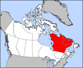
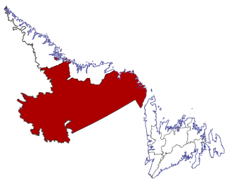
Labrador is a geographic and cultural region within the Canadian province of Newfoundland and Labrador. It is the primarily continental portion of the province and constitutes 71% of the province's area but is home to only 6% of its population. It is separated from the island of Newfoundland by the Strait of Belle Isle. It is the largest and northernmost geographical region in the four Atlantic provinces.

<span class="mw-page-title-main">Innu</span> First Nation in North America

The Innu / Ilnu or Innut / Innuat / Ilnuatsh ("people"), formerly called Montagnais from the French colonial period, are the Indigenous inhabitants of territory in the northeastern portion of the present-day province of Labrador and some portions of Quebec. They refer to their traditional homeland as Nitassinan or Innu-assi.

<span class="mw-page-title-main">Naskapi</span> Ethnic group of Quebec and Labrador, Canada

The Naskapi are an Indigenous people of the Subarctic native to the historical country St'aschinuw, which is located in northern Quebec and Labrador, neighbouring Nunavik. They are closely related to Innu Nation, who call their homeland Nitassinan.

<span class="mw-page-title-main">Labrador Peninsula</span> Large peninsula in eastern Canada

The Labrador Peninsula, also known as the Quebec-Labrador Peninsula, is a large peninsula in eastern Canada. It is bounded by Hudson Bay to the west, the Hudson Strait to the north, the Labrador Sea to the east, and the Gulf of Saint Lawrence to the southeast. The peninsula includes the region of Labrador, which is part of the province of Newfoundland and Labrador, and the regions of Saguenay–Lac-Saint-Jean, Côte-Nord, and Nord-du-Québec, which are in the province of Quebec. It has an area of 1,400,000 km2 (541,000 sq mi).

<span class="mw-page-title-main">Nunatsiavut</span> Autonomous area in Newfoundland and Labrador, Canada claimed by the Inuit

Nunatsiavut is an autonomous area claimed by the Inuit in Newfoundland and Labrador, Canada. The settlement area includes territory in Labrador extending to the Quebec border. In 2002, the Labrador Inuit Association submitted a proposal for limited autonomy to the government of Newfoundland and Labrador. The constitution was ratified on December 1, 2005, at which time the Labrador Inuit Association ceased to exist, and the new Government of Nunatsiavut was established, initially being responsible for health, education and cultural affairs. It is also responsible for setting and conducting elections, the first of which was executed in October 2006. An election for the ordinary members of the Nunatsiavut Assembly was held on May 4, 2010. The Nunatsiavut Assembly was dissolved on April 6 in preparation for the election. Its incumbent president is Johannes Lampe who assumed office in 2016.

<span class="mw-page-title-main">Lake Melville</span>

Lake Melville is an estuary of Hamilton Inlet on the Labrador coast of the Canadian province of Newfoundland and Labrador. Comprising 3,069 km2 (1,185 sq mi) and stretching 140 km (87 mi) inland to Happy Valley-Goose Bay, it forms part of the largest estuary in the province, primarily draining the Churchill River and Naskaupi River watersheds. Both Lake Melville and Hamilton Inlet are encircled by mountains, with primary settlements at Happy Valley-Goose Bay, North West River, and Sheshatshiu. It is the 46th largest lake globally.

<span class="mw-page-title-main">Nain, Newfoundland and Labrador</span> Inuit community in Newfoundland and Labrador, Canada

Nain is the northernmost permanent settlement in the Canadian province of Newfoundland and Labrador, within the Nunatsiavut region, located about 370 km (230 mi) by air from Happy Valley-Goose Bay. The town was established as a Moravian mission in 1771 by Jens Haven and other missionaries. As of 2021, the population is 1,204 mostly Inuit and mixed Inuit-European. Nain is the administrative capital of the autonomous region of Nunatsiavut.

<span class="mw-page-title-main">Hopedale, Newfoundland and Labrador</span> Inuit community in Newfoundland and Labrador, Canada

Hopedale is a town located in the north of Labrador, the mainland portion of the Canadian province of Newfoundland and Labrador. Hopedale is the legislative capital of the Inuit Land Claims Area Nunatsiavut, and where the Nunatsiavut Assembly meets. As of the 2021 census, it has a population of 596.

<span class="mw-page-title-main">Lake Melville (electoral district)</span> Provincial electoral district in Newfoundland and Labrador, Canada

Lake Melville is a provincial electoral district for the House of Assembly of Newfoundland and Labrador, Canada. As of 2011, there are 6,647 eligible voters living within the district.

<span class="mw-page-title-main">Rigolet</span> Inuit community in Newfoundland and Labrador, Canada

Rigolet is a remote, coastal Labrador community established in 1735 by French-Canadian trader Louis Fornel. The town is the southernmost officially recognized Inuit community in the world. Located on Hamilton Inlet, which is at the entrance to fresh water Lake Melville; Rigolet is on salt water and is accessible to navigation during the winter. Although there is no road access, the community is accessible by snowmobile trail, the Rigolet Airport, or seasonally via a coastal ferry from Happy Valley-Goose Bay.

<span class="mw-page-title-main">Sheshatshiu</span> Indian reserve in Newfoundland and Labrador, Canada

Sheshatshiu is an Innu federal reserve and designated place in the Canadian province of Newfoundland and Labrador. The reserve is approximately 40 kilometres (25 mi) north of Happy Valley-Goose Bay. Some references may spell the community's name as Sheshatshit, the t spelling is more traditional in the Innu-aimun language, but the u is used more commonly in English to avoid inappropriate connotations. The name means "a narrow place in the river".

<span class="mw-page-title-main">Postville, Newfoundland and Labrador</span> Town in Newfoundland and Labrador, Canada

Postville is an Inuit town in the north of Labrador, Canada. It had a population of 188 as of 2021. It is located about 40 km (25 mi) into the interior of Kaipokok Bay, 180 km (110 mi) NNE of Happy Valley-Goose Bay. Postville Airport is nearby.

<span class="mw-page-title-main">Division No. 10, Newfoundland and Labrador</span> Census division in Newfoundland and Labrador, Canada

Census Division No. 10 of Newfoundland and Labrador is composed of the Labrador region of the province, excluding Nunatsiavut. It has a land area of 199,703 km² (77,105.8 sq mi) and at the 2016 census had a population of 24,639, up from 24,111 in 2011. Its two major population centres are the towns of Happy Valley-Goose Bay and Labrador City.

<span class="mw-page-title-main">George River (Quebec)</span> River in Quebec, Canada.

George River, formerly the East or George's River, is a river in northeastern Quebec, Canada, that flows from Lake Jannière mainly north to Ungava Bay.

Lodge Bay is a local service district and designated place in the Canadian province of Newfoundland and Labrador. It is on the southeast coast of Labrador. Encompassing a population of less than one hundred residents, the community has uniquely evolved from both early European colonization of Labrador, and the inimitable patterns of land and resource use by the migratory Inuit population. The name Lodge Bay originated from the title Ranger Lodge, which was the name given to the area by trader and explorer, Captain George Cartwright in the late 18th century. "Ranger" was the name of the wooden-mercantile ship Cartwright used to trade, map and explore the Labrador coast, while "Lodge" was the name given to English hunting camps in Great Britain at that time.

<span class="mw-page-title-main">NunatuKavut</span> Proposed Autonomous area in Newfoundland and Labrador, Canada

NunatuKavut is an unrecognized Inuit territory in Labrador. The NunatuKavut people claim to be the direct descendants of the Inuit that lived south of the Churchill or Grand River prior to European contact, with recent European admixture primarily from English settlers. Despite claims of Inuit heritage, according to recent censuses completed by Statistics Canada, the vast majority of individuals living in NunatuKavut communities continue to identify as Métis as opposed to 'Inuit'.

<span class="mw-page-title-main">Nunatsiavut Assembly</span>

The Nunatsiavut Assembly is the legislative branch of the government of Nunatsiavut, Canada.

<span class="mw-page-title-main">Newfoundland and Labrador Route 520</span> Highway in Newfoundland and Labrador

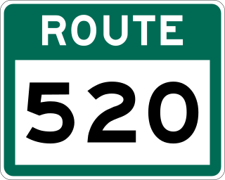
Route 520, also known as North West River Road, is a 45-kilometre-long (28 mi) north-south supplementary highway off of the Trans-Labrador Highway in Labrador, which connects Happy Valley-Goose Bay to North West River.

<span class="mw-page-title-main">John McLean (explorer)</span>

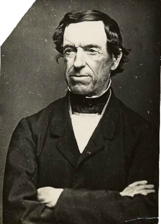
John McLean was a Scotsman who emigrated to British North America, where he became a fur-trapper, trader, explorer, grocer, banker, newspaperman, clerk, and author. He travelled by foot and canoe from the Atlantic to the Pacific and back, becoming one of the chief traders of the Hudson's Bay Company. He is remembered as the first person of European descent to discover Churchill Falls on Canada's Churchill River and sometimes mistakenly credited as the first to cross the Labrador Peninsula. Long overlooked, his first-person accounts of early 19th-century fur trading in Canada are now valued by historians. Under the pen name Viator, his letters to newspapers around Canada also helped shift public opinion away from yielding the western territories to the United States during the Alabama Claims dispute over damages for British involvement in the American Civil War.

References

  1. "Official results of May 3 general election for Ordinary Members to the Nunatsiavut Assembly" (PDF). Nunatsiavut.com. Retrieved 30 May 2022.
  2. 1 2 "Population and dwelling counts: Canada, provinces and territories, census divisions and census subdivisions (municipalities), Newfoundland and Labrador". Statistics Canada. February 9, 2022. Retrieved March 15, 2022.
  3. "Canadian Forts: Labrador", North American Forts .
  4. "Innu : Labrador Virtual Museum". Labradorvirtualmuseum.ca. Retrieved 2019-09-25.
  5. "Precontact Innu Land Use". Heritage.nf.ca. Retrieved 2019-09-25.
  6. "Our History : Town of North West River". Townofnwr.ca. Retrieved 30 May 2022.
  7. "Labrador". Labradormetis.ca. Retrieved 30 May 2022.
  8. "CHE RM Demo". Ourlabrador.ca. Retrieved 30 May 2022.
  9. "Museums : Town of North West River". Townofnwr.ca. Retrieved 30 May 2022.
  10. "Grenfell Mission Nurses". Canada's History Society. Retrieved December 29, 2022.
  11. "Sir Wilfred Grenfell". Encyclopædia Britannica. October 5, 2022. Retrieved December 29, 2022.
  12. Hubbard, Mina Benson (2004). Grace, Sherrill (ed.). A Woman's Way through Unknown Labrador. Montreal & Kingston: MQUP. ISBN   0-7735-2704-4.
  13. "The total solar eclipse 1905 : Reports of observations made by members of the British Astronomical Association of the total solar eclipse of 1905, August 30". Archive.org. London : British Astronomical Association. 30 May 1906. Retrieved 30 May 2022.
  14. Scott, J.M., (1933). The Land that God gave Cain. Chatto and Windus, London.
  15. Leslie, L.A.D., (1931). Wilderness trails in three continents. Heath Cranton, London.
  16. Watts, Beatrice (1984). Cable Car of North River & Sheshatshit. Them Days (booklet). p. 8.
  17. Katie Breen (15 February 2017). "Last Stop Garage: North West River gets reality TV show". CBC News.
  18. "Pilot". Last Stop Garage. Episode 1. Discovery Channel Canada.
  19. "Reserve Creation at Sheshatshiu". Indigenous and Northern Affairs Canada. 25 May 2021.
  20. 1 2 "Census Profile, 2016 Census - North West River, Town [Census subdivision], Newfoundland and Labrador and Newfoundland and Labrador [Province]". 12.statcan.gc.ca. 8 February 2017. Retrieved 30 May 2022.
  21. [ dead link ]
  22. "Facts & Figures : Town of North West River". Townofnwr.ca. Retrieved 30 May 2022.