Norton St Philip

Last updated

Norton Saint Philip
StPhilip&StGeorgeNortonStPhilip.jpg
Somerset UK location map.svg
Red pog.svg
Norton Saint Philip
Location within Somerset
Population858 (2011 Census) [1]
OS grid reference ST775555
Civil parish
  • Norton St Philip
Unitary authority
Ceremonial county
Region
Country England
Sovereign state United Kingdom
Post town BATH
Postcode district BA2
Dialling code 01373
Police Avon and Somerset
Fire Devon and Somerset
Ambulance South Western
UK Parliament
Website Norton St Philip Parish Council
List of places
UK
England
Somerset
51°17′53″N2°19′19″W / 51.298°N 2.322°W / 51.298; -2.322

Norton St Philip is a village and civil parish in Somerset, England. The village lies about 5+12 miles (9 km) south of the city of Bath and 5 miles (8 km) north of the town of Frome on the eastern slopes of the Mendip Hills. It is situated on the A366 between Trowbridge and Radstock, and on the B3110 between Bath and Frome.

Contents

The village has experienced a significant reduction in local services, with the police station, post office and shops closing throughout the early 2000s. This was partly reversed by the opening of a new supermarket, incorporating a post office, in 2016.

The village is built around a village common, known as Churchmead or The Mead, which is held in trust and is home to the village cricket team.

History

The earliest signs of habitation can be found a mile to the east of the current village, where the Roman road from Bath to Poole passed. The village is later recorded in the Domesday book as supporting 20 people, three ploughs, a mill and 20 acres (81,000 m2) of meadow. A priory was founded near the village in 1232 and had links with the village until its dissolution under the orders of Henry VIII on 31 March 1540. Norton developed a thriving wool trade and became the site of a regional market, signs of which can be seen in local surnames such as Weaver. The parish of Norton St Philip was part of the Wellow Hundred. [2]

Norton St Philip was the site of the Battle of Norton St Philip during the Monmouth Rebellion in 1685, and the east–west street on the village's northern edge, officially recorded as Chevers Lane, is referred to locally as Bloody Lane, reportedly as the battle caused so much bloodshed it flowed down this hill. In the aftermath of the failed rebellion Judge Jefferies conducted 12 executions on The Mead, as part of the Bloody Assizes. The route he took to The Mead is known as Jefferies Gate.

The George Inn, one of a number of establishments that claim to be Britain's oldest tavern, is located in the centre of the village. It was built in the 14th or 15th century, [3] as a wool store for the priory at Hinton Charterhouse [4] and to accommodate travellers and merchants coming to the annual wool fairs that were held in the village from the late 13th century until 1902. In the 15th century the timber-framed upper floors were added. [5] The inn became part of the stage coach route between London and the South West; on 12 June 1668 the noted diarist Samuel Pepys, with his wife and servants, passed through Norton St Philip on their way to Bath from Salisbury. [4] The inn was later used as the headquarters of Monmouth's army after his retreat from Bath, and was further used as a court by Judge Jefferies.

Faccenda operated a poultry processing plant in the village until the late 1990s, when the property burned down. The site was subsequently redeveloped for housing between 2012-14, adding approximately 57 dwellings and a small supermarket to the south side of the village. [6] The development uses materials and a style sympathetic to the local vernacular, with architectural elements inspired by local historic buildings. The development also included a building intended for use as a public space, which has since been repurposed into a residential dwelling.

Governance

The parish council has responsibility for local issues, including setting an annual precept (local rate) to cover the council's operating costs and producing annual accounts for public scrutiny. The parish council evaluates local planning applications and works with the local police, district council officers, and neighbourhood watch groups on matters of crime, security, and traffic. The parish council's role also includes initiating projects for the maintenance and repair of parish facilities, as well as consulting with the district council on the maintenance, repair, and improvement of highways, drainage, footpaths, public transport, and street cleaning. Conservation matters (including trees and listed buildings) and environmental issues are also the responsibility of the council.

From 1894 to 1974, the village was part of Frome Rural District, [7] and from 1974 to 2023, it fell within the non-metropolitan district of Mendip. Mendip District Council was responsible for local planning and building control, local roads, council housing, environmental health, markets and fairs, refuse collection and recycling, cemeteries and crematoria, leisure services, parks, and tourism.

Somerset County Council is responsible for running the largest and most expensive local services such as education, social services, libraries, main roads, public transport, policing and fire services, trading standards, waste disposal and strategic planning.

It is also part of the Somerton and Frome county constituency represented in the House of Commons of the Parliament of the United Kingdom. It elects one Member of Parliament (MP) by the first past the post system of election.

Community

The village has a strong sense of local community, supported in part by the village pubs, The George Inn and the Fleur-de-Lys, the local primary school, and the cricket team. The village is well known in the area for hosting a large fundraising Bonfire Night celebration.

Transport

Situated around the crossroads of the A366 and the B3110, the village is largely a dormitory settlement for the surrounding towns. [8] The High Street is a congested commuting route into Bath and measures have been taken to slow down the rat run traffic through the village by the installation of bollards to inhibit traffic mounting the pedestrian footpath. [9] After a series of traffic incidents involving damage to residents' cars, a weight limit of 7.5 t was introduced for vehicles driving through the village. [10]

The D2 bus, operated by First West of England, runs an hourly service with a stops located near the cross roads in the centre of the village. [11]

Religious sites

The church of St Philip and St James dates from the 14th century with restoration in 1847 by Sir George Gilbert Scott. It has been designated by English Heritage as a Grade II* listed building. [12]

Related Research Articles

<span class="mw-page-title-main">Frome</span> Town in Somerset, England

Frome is a town and civil parish in Somerset, England, on uneven high ground at the eastern end of the Mendip Hills and on the River Frome, 13 miles (21 km) south of Bath. The population of the parish was 28,559 in 2021.

<span class="mw-page-title-main">Buckland Dinham</span> Human settlement in England

Buckland Dinham is a small village near Frome in Somerset, England. The village has a population of 381. The village's main industry is farming, but the village is also a dormitory village for the nearby cities of Bath and Bristol.

<span class="mw-page-title-main">Pensford</span> Human settlement in England

Pensford is the largest village in the civil parish of Publow in Somerset, England. It lies in the Chew Valley, approximately 7 miles (11 km) south of Bristol, 8 miles (13 km) west of Bath, and 14 miles (23 km) north of Wells. It is on the A37 road from Bristol to Shepton Mallet.

<span class="mw-page-title-main">Chilcompton</span> Human settlement in England

Chilcompton is a village and civil parish in Somerset, England, situated in the Mendip Hills two miles south of Midsomer Norton and 3.0 miles south-west of Westfield. It is situated on the B3139 road between Radstock and Wells, close to the A37.

<span class="mw-page-title-main">Wellow, Somerset</span> Human settlement in England

Wellow is a village and civil parish in Somerset, England, about 5 miles (8.0 km) south of Bath. The parish, which includes the hamlets of Twinhoe, White Ox Mead, Baggridge and part of Midford has a population of 529. The village itself falls within the southernmost boundary of the Cotswolds Area of Outstanding Natural Beauty and is recognised as having special architectural and historic interest, which led to it being designated as a Conservation Area in 1983.

<span class="mw-page-title-main">Whatley, Mendip</span> Human settlement in England

Whatley is a small rural village and civil parish about 2.5 miles (4 km) west of Frome in the English county of Somerset. The parish lies south of Mells and north of Nunney, and includes the hamlets of Lower Whatley and Chantry.

<span class="mw-page-title-main">Beckington</span> Human settlement in England

Beckington is a village and civil parish in Somerset, England, across the River Frome from Lullington about three miles north of Frome. According to the 2011 census the parish, which includes the hamlet of Rudge, which has a population of 983, and the hamlet of Standerwick.

<span class="mw-page-title-main">Rode, Somerset</span> Human settlement in England

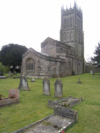
Rode is a village and civil parish in the ceremonial county of Somerset in England, 5 miles (8.0 km) north-east of Frome and 5 miles (8.0 km) south-west of Trowbridge.

<span class="mw-page-title-main">Mells, Somerset</span> Village in Somerset, England

Mells is a village and civil parish in Somerset, England, near the town of Frome.

<span class="mw-page-title-main">Cranmore, Somerset</span> Human settlement in England

Cranmore is a village and civil parish east of Shepton Mallet, in the Mendip district of Somerset, England. The parish includes the hamlets of Waterlip, East Cranmore and Dean.

<span class="mw-page-title-main">Croscombe</span> Human settlement in England

Croscombe is a village and civil parish 2 miles (3 km) west of Shepton Mallet and 4 miles (6 km) from Wells, in the Mendip district of Somerset, England. It is situated on the A371 road in the valley of the River Sheppey.

<span class="mw-page-title-main">Great Elm</span> Village in Somerset, England

Great Elm is a village and civil parish between Mells and Frome in the Mendip district of Somerset, England. The parish includes the hamlet of Hapsford.

<span class="mw-page-title-main">Hemington, Somerset</span> Human settlement in England

Hemington is a village and civil parish 5.5 miles (8.9 km) north west of Frome, in the Mendip district of Somerset, England. It is located just off the A366 between Trowbridge and Radstock. The parish includes the villages of Hardington, Faulkland and Foxcote.

<span class="mw-page-title-main">Lullington, Somerset</span> Human settlement in England

Lullington is a village and civil parish just across the Mells River from Beckington and 2.5 miles (4.0 km) north east of Frome, in the Mendip district of Somerset, England.

<span class="mw-page-title-main">Milton Clevedon</span> Human settlement in England

Milton Clevedon is a village and civil parish 1 mile (1.6 km) south of Evercreech in the Mendip district of Somerset, England.

<span class="mw-page-title-main">Selwood, Somerset</span> Human settlement in England

Selwood used to be a village but is now part of the suburbs of Frome. It is a civil parish in the Mendip district of Somerset, England. The parish includes the villages of East and West Woodlands, Rodden and the hamlets of Alder Row and Blatchbridge.

<span class="mw-page-title-main">Tellisford</span> Human settlement in England

Tellisford is a village and civil parish 6 miles (10 km) north-east of Frome in the Mendip district of Somerset, England. The parish includes the village of Woolverton.

<span class="mw-page-title-main">Trudoxhill</span> Human settlement in Somerset, England

Trudoxhill is a village and civil parish near Nunney in Somerset, England.

<span class="mw-page-title-main">The George Inn, Norton St Philip</span> Grade I listed pub in Somerset, England

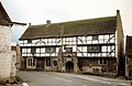
The George Inn is an historic establishment in Norton St Philip, England. Built in the 14th or 15th century, the inn has been designated as a Grade I listed building and is one of a number of establishments that claims to be Britain's oldest tavern.

<span class="mw-page-title-main">Leigh-on-Mendip</span> Human settlement in England

Leigh-on-Mendip or Leigh upon Mendip is a small village on the Mendip Hills in Somerset, England. It lies roughly equidistant from Frome, Radstock and Shepton Mallet at about 5 miles (8 km) from each town.

References

  1. "Norton St Philip Parish". Neighbourhood Statistics. Office for National Statistics. Retrieved 1 January 2014.
  2. "Somerset Hundreds". GENUKI. Retrieved 22 October 2011.
  3. Historic England. "The George Inn (1174953)". National Heritage List for England . Retrieved 1 March 2008.
  4. 1 2 Leete-Hodge, Lornie (1985). Curiosities of Somerset. Bodmin: Bossiney Books. p. 20. ISBN   0-906456-98-3.
  5. Scott, Shane (1995). The hidden places of Somerset. Aldermaston: Travel Publishing Ltd. p. 37. ISBN   1-902007-01-8.
  6. "Fortescue Fields, Bath | Residential Development Architects, Winchester, London". ADAM Architecture. Retrieved 6 May 2024.
  7. "Frome RD". A Vision of Britain Through Time. University of Portsmouth . Retrieved 4 January 2014.
  8. "Norton St Philip (Primary Village)". Mendip Council. Retrieved 26 February 2018.
  9. "Norton St Phillip villagers frustrated over lorries breaking weight limits". BBC. Retrieved 26 February 2018.
  10. "Traffic Regulation Order – Determination Report: (The A366, Norton St Philip)(7.5 Tonne Weight Restriction Order) 2009" (PDF). Somerset County Council. Retrieved 27 March 2010.
  11. "D2 - Bath Bus Station - Frome, Sainsbury's Superstore". bustimes.org. Retrieved 6 May 2024.
  12. Historic England. "Church of St Philip and St James (1345373)". National Heritage List for England . Retrieved 1 March 2008.