Offa's Dyke

Last updated

Offa's Dyke
Clawdd Offa
Offa's Dyke near Clun.jpg
Offa's Dyke near Clun, Shropshire, England
Offa's Dyke
Location England–Wales border
Designer King Offa
Type Earthwork
MaterialEarth
Length82 mi (132 km) but covers an area of up to 150 mi (240 km) [1]
Width20 m (66 ft)
Height2.5 m (8 ft 2 in)
Completion date 784

Offa's Dyke (Welsh : Clawdd Offa) is a large linear earthwork that roughly follows the border between England and Wales. The structure is named after Offa, the Anglo-Saxon king of Mercia from AD 757 until 796, who is traditionally believed to have ordered its construction. Although its precise original purpose is debated, it delineated the border between Anglian Mercia and the Welsh kingdom of Powys. [2]

Contents

The earthwork, which was up to 65 feet (20 m) wide (including its flanking ditch) and 8 feet (2.4 m) high, traversed low ground, hills and rivers. Today it is protected as a scheduled monument. Some of its route is followed by the Offa's Dyke Path, a 177-mile (285 km) long-distance footpath that runs between Liverpool Bay in the north and the Severn Estuary in the south.

Although the Dyke has conventionally been dated to the Early Middle Ages of Anglo-Saxon England, research in recent decades – using techniques such as radioactive carbon dating – has challenged the conventional historiography and theories about the earthwork and shows that part was started in the early 5th century, during the sub-Roman period.

History

Background

The extent of Mercia during the Mercian Supremacy, showing the line of Offa's Dyke (red) Mercian Supremacy x 4 alt.png
The extent of Mercia during the Mercian Supremacy, showing the line of Offa's Dyke (red)
Wat's Dyke in brown; Offa's Dyke in red Wat's dyke.png
Wat's Dyke in brown; Offa's Dyke in red
Schematic cross-section of Offa's Dyke, showing the design intended to protect Mercia against attacks/raids from Powys. Offa's Dyke cross-section colour.svg
Schematic cross-section of Offa's Dyke, showing the design intended to protect Mercia against attacks/raids from Powys.

The generally accepted theory of the earthwork attributes most of its construction to Offa, King of Mercia from 757 to 796. The structure did not represent a mutually agreed boundary between the Mercians and the Kingdom of Powys. It had a ditch on the Welsh (western) side, with the displaced soil piled into a bank on the Mercian (eastern) side. This suggests that Mercians constructed it as a defensive earthwork, or to demonstrate the power and intent of their kingdom.

Throughout its entire length, the Dyke provides an uninterrupted view from Mercia into Wales. Where the earthwork encounters hills or high ground, it passes to the west of them.

Although historians often overlook Offa's reign because of limitations in source material, he ranks as one of the greatest Anglo-Saxon rulers – as evidenced in his ability to raise the workforce and resources required to construct Offa's Dyke. The construction of the earthwork probably involved a corvée system requiring vassals to build certain lengths of the earthwork for Offa in addition to performing their normal services to their king. The Tribal Hidage, a primary document, shows the distribution of land within 8th-century Britain; it shows that peoples were located within specified territories for administration.

Early scholarship

Offa's Dyke near Presteigne, Powys Offa's Dyke near Yew Tree Farm - geograph.org.uk - 450420.jpg
Offa's Dyke near Presteigne, Powys

The first historians and archaeologists to examine the Dyke seriously compared their conclusions with the late 9th-century writer Asser, who wrote: "there was in Mercia in fairly recent time a certain vigorous king called Offa, who terrified all the neighbouring kings and provinces around him, and who had a great dyke built between Wales and Mercia from sea to sea". [3] In 1955, Sir Cyril Fox published the first major survey of the Dyke. [4] He concurred with Asser that the earthwork ran 'from sea to sea', theorising that the Dyke ran from the River Dee estuary in the north to the River Wye in the south: approximately 150 miles (240 km). Although Fox observed that Offa's Dyke was not a continuous linear structure, he concluded that earthworks were raised in only those areas where natural barriers did not already exist.

Sir Frank Stenton, the UK's most eminent 20th-century scholar on Anglo-Saxon England, accepted Fox's conclusions. He wrote the introduction to Fox's account of the Dyke. Although Fox's work has now been revised to some extent, it still remains a vital record of some stretches of Offa's Dyke that still existed between 1926 and 1928, when his three field surveys took place, but have since been destroyed.

Later research

In 1978, Dr Frank Noble challenged some of Fox's conclusions, stirring up new academic interest in Offa's Dyke. His MPhil thesis entitled "Offa's Dyke Reviewed" (1978) raised several questions concerning the accepted historiography of Offa's Dyke. Noble postulated that the gaps in the Dyke were not due to the incorporation of natural features as defensive barriers, but instead the gaps were a "ridden boundary", perhaps incorporating palisades, that left no archaeological trace. Noble also helped establish the Offa's Dyke Association, which maintains the Offa's Dyke Path. This long-distance footpath mostly follows the route of the dyke and is a designated British National Trail.

John Davies wrote of Fox's study: "In the planning of it, there was a degree of consultation with the kings of Powys and Gwent. On the Long Mountain near Trelystan, the dyke veers to the east, leaving the fertile slopes in the hands of the Welsh; near Rhiwabon, it was designed to ensure that Cadell ap Brochwel retained possession of the Fortress of Penygadden." And, for Gwent, Offa had the dyke built "on the eastern crest of the gorge, clearly with the intention of recognizing that the River Wye and its traffic belonged to the kingdom of Gwent". [5]

Ongoing research and archaeology on Offa's Dyke has been undertaken for many years by the Extra-Mural Department of the University of Manchester. Interviews with Dr David Hill, broadcast in episode 1 of In Search of the Dark Ages (aired in 1979), show support for Noble's idea. Most recently, Hill and Margaret Worthington have undertaken considerable research on the Dyke. Their work, though far from finished, has demonstrated that there is little evidence for the Dyke stretching from sea to sea. Rather, they claim that it is a shorter structure stretching from Rushock Hill north of the Herefordshire Plain to Llanfynydd, near Mold, Flintshire, some 64 miles (103 km). According to Hill and Worthington, dykes in the far north and south may have different dates, and though they may be connected with Offa's Dyke, there is as yet no compelling evidence behind this. However, not all experts accept this view. [6]

Contrary evidence

'Ofer' means 'border' or 'edge' in Old English, giving rise to the possibility of alternative derivations for some border features associated with Offa. [7]

The Roman historian Eutropius in his book Historiae Romanae Breviarium, written around 369, mentions the Wall of Severus, a structure built by Septimius Severus, who was Roman Emperor between 193 and 211:

Novissimum bellum in Britannia habuit, utque receptas provincias omni securitate muniret, vallum per CXXXIII passuum milia a mari ad mare deduxit. Decessit Eboraci admodum senex, imperii anno sexto decimo, mense tertio. Historiae Romanae Breviarium, viii 19.1

He had his most recent war in Britain, and to fortify the conquered provinces with all security, he built a wall for 133 miles from sea to sea. He died at York, a reasonably old man, in the sixteenth year and third month of his reign.

This source is conventionally thought to be referring, in error, to either Hadrian's Wall, 73 miles (117 km), or the Antonine Wall, 37 miles (60 km), which were both shorter and built in the 2nd century. [8] Recently, some writers have suggested that Eutropius may have been referring to the earthwork later called Offa's Dyke. [9] Most archaeologists reject this theory. [10] [11] [12]

The Venerable Bede also mentions the barrier built by Septimus Severus, but Bede says that the rampart was made of earth and timber, a description which would closer match Offa's Dyke than Hadrian's Wall, though it would describe the Antonine Wall:

After many great and severe battles, (Severus) thought fit to divide that part of the island, which he had recovered, from the other unconquered nations, not with a wall, as some imagine, but with a rampart. For a wall is made of stones, but a rampart, with which camps are fortified to repel the assaults of enemies, is made of sods, cut out of the earth, and raised high above the ground, like a wall, having in front of it the trench whence the sods were taken, with strong stakes of wood fixed above it. Thus Severus drew a great trench and strong rampart, fortified with several towers, from sea to sea. Bede’s Ecclesiastical History of England, Bk 1-5

However, the solution to the problem lies a few chapters later in Bede's account. In Book One Chapter Twelve of Bede's Ecclesiastical History , he writes that the Romans "built a strong wall of stone directly from sea to sea in a straight line between the towns that had been built as strong-points, where Severus had built his earthwork ... straight from east to west". The strong wall of stone cannot refer to the Antonine Wall or Offa's Dyke, so it clearly refers to Hadrian's Wall, especially as Offa's Dyke runs from north to south. Also, as Severus's earthwork is described as being in the same location as Hadrian's Wall, it cannot be Offa's Dyke either, so the earth rampart with a great trench that Bede refers to must be the Vallum, the adjoining earthen barrier immediately south of Hadrian's Wall. Where Bede got it wrong was in attributing the Vallum to Septimius Severus, and saying that it predated the Wall. In fact the Vallum was the work of Hadrian, and slightly post-dated the Wall.

Evidence has also been found that challenges the accepted date of the construction of Offa's Dyke. [13] In December 1999, Shropshire County Council archaeologists uncovered the remains of a hearth or fire on the original ground surface beneath Wat's Dyke near Oswestry. Carbon dating analysis of the burnt charcoal and burnt clay in situ showed it was covered by earth on or around AD 446. Archaeologists concluded that this part of Wat's Dyke, so long thought of as Anglo-Saxon and a mid-8th-century contemporary of Offa's Dyke, must have been built 300 years earlier in the post-Roman period. [14]

In 2014, excavations by the Clwyd-Powys Archaeological Trust focused on nine samples of the Dyke near Chirk. [15] Radiocarbon dating of redeposited turf resulted in a series of dates. In one section, these ranged from AD 430 to AD 652 and in another section from AD 887 to AD 1019: confirming that the bank is clearly post-Roman, and that at least some rebuilding work took place after Offa's reign. [16] It has been suggested that Offa's Dyke may have been a long-term project by several Mercian kings. [17] Further excavations by Clwyd-Powys Archaeological Trust on the Dyke at Chirk Castle found well-preserved remains of the ditch under later parkland; radiocarbon samples were recovered, but the results have not yet been made public. [18]

Current

The England–Wales border still mostly passes within a few miles of the course of Offa's Dyke through the Welsh Marches. A 3-mile (4.8 km) section of the Dyke which overlooks Tintern Abbey and includes the Devil's Pulpit near Chepstow is now managed by English Heritage.

Statutory protection

All sections of Offa's Dyke that survive as visible earthworks, or as infilled but undeveloped ditch, are designated as a scheduled monument. However, some parts of the Dyke may also remain buried under later development. [19] Some sections are also defined as Sites of Special Scientific Interest, including stretches within the Lower Wye Valley SSSI and the Highbury Wood National Nature Reserve. Parts are located within the Wye Valley and Shropshire Hills Areas of Outstanding Natural Beauty. Most of the line of Offa's Dyke is designated as a public right of way, including those sections which form part of the Offa's Dyke Path. [19]

In August 2013, a 45-metre (148 ft) section of Dyke, between Chirk and Llangollen, was destroyed by a local landowner. The destruction of the Dyke to build a stable was said to be like "driving a road through Stonehenge", but the perpetrator escaped punishment. [20]

Candidate World Heritage Site

In 2010, the Dyke was proposed by the Offa's Dyke Association and local authorities for World Heritage Site status. [19] Part of the proposal stated:

Offa’s Dyke is a victim of its very scale, nature, meaning and historical success. It is located in two countries, six local authority areas, multiple ownerships and multiple land-use contexts. The main professional stakeholders – such as the English and Welsh path and heritage management agencies – are organisationally and functionally separate. The ancient monument is now often seen as secondary to the modern path, and heritage advice about individual dyke sections is not generally coordinated via any connected overview of the values of the whole monument. Moreover, despite the lasting legacy of Offa's Dyke for English and Welsh communities alike, there is limited public awareness of the monument and its remarkable link to modern ideas of national identity.

The proposal was rejected in 2011. [21]

Offa's Dyke Centre at Knighton, Powys Offa's Dyke Centre 2008.jpg
Offa's Dyke Centre at Knighton, Powys

The Offa's Dyke Centre

The Offa's Dyke Centre is a purpose-built information centre in the town of Knighton, on Offa's Dyke on the border between England (Shropshire) and Wales (Powys). Some of the best remains of the earthworks can be seen within a two-minute walk from the centre.

Offa's Dyke Path

The Offa's Dyke Path (Welsh: Llwybr Clawdd Offa) is a long-distance footpath close to the England–Wales border. Although large sections are close to the Dyke itself, the Path is longer, and in some places passes at some distance from the earthworks. Opened on 10 July 1971, the Path is one of Britain's longest National Trails, stretching for 283 km (176 mi) from the Severn estuary at Sedbury, near Chepstow, to Prestatyn on the north Wales coast. [22] There is a visitor centre at Knighton. [23]

Cultural importance

The dyke has a cultural significance symbolising the separation between England and Wales: a symbolism similar to Hadrian's Wall between England and Scotland in the Scottish Marches. George Borrow, in his Wild Wales (1862), drawn from folklore, claimed that:

[It] was customary for the English to cut off the ears of every Welshman who was found to the east of the dyke, and for the Welsh to hang every Englishman whom they found to the west of it.

See also

Related Research Articles

<span class="mw-page-title-main">Offa of Mercia</span> Anglo-Saxon King of Mercia from 757 to 796

Offa was King of Mercia, a kingdom of Anglo-Saxon England, from 757 until his death. The son of Thingfrith and a descendant of Eowa, Offa came to the throne after a period of civil war following the assassination of Æthelbald. Offa defeated the other claimant, Beornred. In the early years of Offa's reign, it is likely that he consolidated his control of Midland peoples such as the Hwicce and the Magonsæte. Taking advantage of instability in the kingdom of Kent to establish himself as overlord, Offa also controlled Sussex by 771, though his authority did not remain unchallenged in either territory. In the 780s he extended Mercian Supremacy over most of southern England, allying with Beorhtric of Wessex, who married Offa's daughter Eadburh, and regained complete control of the southeast. He also became the overlord of East Anglia and had King Æthelberht II of East Anglia beheaded in 794, perhaps for rebelling against him.

<span class="mw-page-title-main">Offa's Dyke Path</span> Footpath in Wales and England

Offa's Dyke Path is a long-distance footpath loosely following the Wales–England border. Officially opened on 10 July 1971, by Lord Hunt, it is one of Britain's National Trails and draws walkers from throughout the world. About 60 miles (97 km) of the 177-mile (285 km) route either follows, or keeps close company with, the remnants of Offa's Dyke, an earthwork traditionally thought to have been constructed in the late 8th century on the orders of King Offa of Mercia.

<span class="mw-page-title-main">Cornovii (Midlands)</span> Celtic people of the Iron Age and Roman Britain

The Cornovīī were a Celtic people of the Iron Age and Roman Britain, who lived principally in the modern English counties of Cheshire, Shropshire, north Staffordshire, north Herefordshire and eastern parts of the Welsh counties of Flintshire, Powys and Wrexham. Their capital in pre-Roman times was probably a hillfort on the Wrekin. Ptolemy's 2nd-century Geography names two of their towns: Deva Victrix (Chester) and Viroconium Cornoviorum (Wroxeter), which became their capital under Roman rule.

<span class="mw-page-title-main">Knighton, Powys</span> Town in Powys, Wales and Shropshire, England

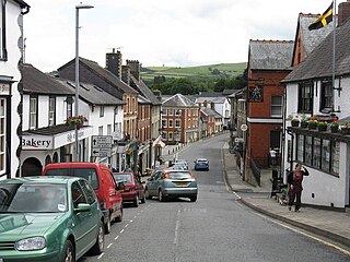
Knighton is a market town and community on the River Teme, straddling the border between Powys, Wales and Shropshire, England. It lies in the traditional county of Radnorshire. Originally an Anglo-Saxon settlement, Knighton is located on Offa's Dyke, the ancient earthwork that divided the two countries. It later became a Norman defensive border town.

<span class="mw-page-title-main">Kingdom of Powys</span> 400s–1160 kingdom in east-central Wales

The Kingdom of Powys was a Welsh successor state, petty kingdom and principality that emerged during the Middle Ages following the end of Roman rule in Britain. It very roughly covered the northern two-thirds of the modern county of Powys and part of today's English West Midlands. More precisely, and based on the Romano-British tribal lands of the Ordovices in the west and the Cornovii in the east, its boundaries originally extended from the Cambrian Mountains in the west to include the modern West Midlands region of England in the east. The fertile river valleys of the Severn and Tern are found here, and this region is referred to in later Welsh literature as "the Paradise of Powys".

<span class="mw-page-title-main">Chirk Castle</span> Castle in north-east Wales, built in 1295

Chirk Castle is a Grade I listed castle located in Chirk, Wrexham County Borough, Wales. It is now owned and run by the National Trust.

<span class="mw-page-title-main">Wat's Dyke</span> Linear earthwork in Wales and England

Wat's Dyke is a 40-mile (64 km) linear earthwork running through the northern Welsh Marches from Basingwerk Abbey on the River Dee estuary, passing east of Oswestry and on to Maesbury in Shropshire, England. It runs generally parallel to Offa's Dyke, sometimes within a few yards but never more than three miles (5 km) away. It now appears insignificant, sometimes a raised hedgerow and in other places is now no more than a cropmark, the ditch long since filled in and the bank ploughed away, but originally it was a considerable construction, considered to be strategically more sophisticated than Offa's Dyke. The date of construction is disputed, ranging from sub-Roman to the early ninth century.

<span class="mw-page-title-main">Vallum (Hadrian's Wall)</span> Earthwork associated with Hadrians Wall, England

The Vallum is a huge earthwork associated with Hadrian's Wall in England. Unique on any Roman frontier, it runs practically from coast to coast to the south of the wall.

<span class="mw-page-title-main">Hadrian's Wall</span> Defensive fortification in Roman Britain

Hadrian's Wall, also known as the Roman Wall, Picts' Wall, or Vallum Aelium in Latin, is a former defensive fortification of the Roman province of Britannia, begun in AD 122 in the reign of the Emperor Hadrian. Running from Wallsend on the River Tyne in the east to Bowness-on-Solway in the west of what is now northern England, it was a stone wall with large ditches in front of it and behind it that crossed the whole width of the island. Soldiers were garrisoned along the line of the wall in large forts, smaller milecastles, and intervening turrets. In addition to the wall's defensive military role, its gates may have been customs posts.

<span class="mw-page-title-main">Antonine Wall</span> Defensive fortification in Roman Britain

The Antonine Wall, known to the Romans as Vallum Antonini, was a turf fortification on stone foundations, built by the Romans across what is now the Central Belt of Scotland, between the Firth of Clyde and the Firth of Forth. Built some twenty years after Hadrian's Wall to the south, and intended to supersede it, while it was garrisoned it was the northernmost frontier barrier of the Roman Empire. It spanned approximately 63 kilometres and was about 3 metres high and 5 metres wide. Lidar scans have been carried out to establish the length of the wall and the Roman distance units used. Security was bolstered by a deep ditch on the northern side. It is thought that there was a wooden palisade on top of the turf. The barrier was the second of two "great walls" created by the Romans in Great Britain in the second century AD. Its ruins are less evident than those of the better-known and longer Hadrian's Wall to the south, primarily because the turf and wood wall has largely weathered away, unlike its stone-built southern predecessor.

<span class="mw-page-title-main">Clwyd-Powys Archaeological Trust</span> Welsh archaeological charity

The Clwyd-Powys Archaeological Trust is an educational charity which was established in 1975. Its objective is ‘to advance the education of the public in archaeology’. CPAT is one of four Welsh Archaeological Trusts (WATs) which work to help protect, record and interpret all aspects of the historic environment. This includes providing advice to local authorities on archaeology and planning, undertaking archaeological projects for private- and public-sector clients, and delivering a programme of community archaeology events and activities.

<span class="mw-page-title-main">England–Wales border</span> National boundary between England and Wales

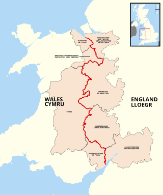
The England–Wales border, sometimes referred to as the Wales–England border or the Anglo-Welsh border, runs for 160 miles (260 km) from the Dee estuary, in the north, to the Severn estuary in the south, separating England and Wales.

<span class="mw-page-title-main">Wall of Severus</span> Roman fortification in northern Britannia

The Wall of Severus is believed to be a defensive fortification built by the Roman Emperor Septimius Severus during his military campaigns in northern Britannia in the early 3rd century. Although the structure is mentioned in several classical texts, its precise location is academically disputed due to inconsistencies between sources. Scholarly consensus believes they are most likely referring to the Antonine Wall. However, Hadrian's Wall and Offa's Dyke have both been suggested as possible candidates. Archaeological evidence has been discovered showing parts of Offa's Dyke, on the England-Wales border, is at least as old as the mid 5th century, predating the 8th-century reign of the Saxon King Offa of Mercia by 300 years.

<span class="mw-page-title-main">Long Mountain (Powys)</span>

Long Mountain is a hill straddling the boundary between Powys (Wales) and Shropshire (England) to the east of Welshpool though the summit at 408 metres at Beacon Ring is within Wales. Long Mountain is a Marilyn, having a prominence of 305 metres.

<span class="mw-page-title-main">Brompton, Shropshire</span> Human settlement in England

Brompton is a hamlet in Shropshire, England. It lies on the A489 between Church Stoke and Newtown at its junction with the B4385. The hamlet is notable for the fact that it is impossible to reach any other settlement in England by road without first passing through Wales. Public footpaths are the only access which links it with the rest of England. It is, however, not geographically an exclave. It is also notable as having Welsh language road signage on the B4385 heading south into Powys, unique in England.

<span class="mw-page-title-main">Moel y Gaer, Bodfari</span> Iron Age hillfort in Denbighshire, Wales

Moel y Gaer is an Iron Age hillfort at the northern end of the Clwydian Range, located on a summit overlooking the valley of the River Wheeler, near the village of Bodfari, Denbighshire, Wales, five miles north-east of Denbigh. The site is a scheduled monument, classified as a prehistoric defensive hillfort.

<span class="mw-page-title-main">River Eitha</span> River in Wales

The River Eitha is a small river in Wrexham County Borough, Wales. It is part of the River Dee catchment. Its name was probably derived from the Welsh word eithaf - "extremity", "farthest".

The Vale of Montgomery is an area of low land straddling the border between Shropshire, England and the former county of Montgomeryshire, Wales. The three principal settlements within it are the former county town of Montgomery and the village of Churchstoke, both in Wales, and Chirbury in England. The earthworks of Offa's Dyke run NNW-ESE through the middle of the vale and are followed by the Offa's Dyke Path. The national boundary also follows this monument for 3 km within the vale. The River Camlad rises to the southeast of the vale whilst its tributary the Caebitra rises to its southwest. They combine at Churchstoke and flow north within a gorge along the eastern margin of the vale, before turning west across the north end of the vale to join the River Severn.

References

  1. "History of Offa's Dyke". English Heritage.
  2. Lunga, Peter (11 January 2022). "Offas dike". Store norske leksikon (in Norwegian). Retrieved 5 May 2023.
  3. Asser, Life of Alfred, p. 14
  4. Fox 1955
  5. Davies, John (2007) [1993]. A History of Wales. London: Penguin. pp. 65–66.
  6. "Ian Bapty review of Hill and Worthington, Offa's Dyke: History and Guide, 2003". Archived from the original on 3 March 2016. Retrieved 20 November 2008.
  7. "ofer". 29 April 2022 via Wiktionary.
  8. Smith, William (1875). Dictionary of Greek and Roman Antiquities. London: John Murray. p. 762.
    Eutropius uses the figure cxxxii (132) milia passuum. As a Roman mile ≈1,479 metres (4,852 ft), 132 Roman miles = 195 km (or 121 statute miles); Offa's Dyke is around 192 km long (a little over 119 statute miles).
  9. Blake, Steve; Lloyd, Scott (2000). The Keys To Avalon. Element Books. ISBN   1-86204-735-9.
  10. "CPAT: New book claims that Offa's Dyke is Roman!, article by Ian Bapty". Archived from the original on 3 March 2016. Retrieved 17 October 2009.
  11. "What is Offa's Dyke?". The Clwyd-Powys Archaeological Trust. 16 October 2009. Archived from the original on 6 October 2015. Retrieved 16 October 2009.
  12. Matthews, Keith. "Was Offa's Dyke actually the 'Wall of Severus'".
  13. "Latest thinking about OFFA'S and WAT'S DYKES". New Welsh Review 52. 16 October 2009.
  14. Hannaford, H.R (1999). Archaeological Investigation on Wat's Dyke at Maes-y-Clawdd, Oswestry. Archaeology Service, Shropshire County Council.
    "The excavation produced some residual deposits of worn sherds of Roman Samian ware and coarseware pottery. The report suggests that the dyke should be 'regarded as being contemporary with the other great 5th-century linear earthwork, the Wansdyke in Wiltshire ... an achievement of the post-Roman kingdom of the northern Cornovii, rather than a work of 7th–8th century Mercia.' However, Dr David Hill, senior research fellow, Centre for Angio-Saxon Studies, University of Manchester ('Offa Versus The Welsh' – British Archaeoiogy, December 2000) has argued for a date later than the 6th century for Wat's Dyke – that it was constructed as Gwynedd and North Powys briefly became a unified state. Evidence from both dykes suggests, he says, that people were not settling or spending much time in these 'wild zones'."
  15. Grant, Ian, Offa's Dyke De138, Chirk, Wrexham: Survey, Excavation and recording, Clwyd-Powys Archaeological Trust
  16. Belford, Paul (2017), "Offa's Dyke: a line in the landscape", in Jenkins, Tim; Abbis, Rachel (eds.), Fortress Salopia, Helion Press, pp. 60–81, ISBN   978-1-91-151-269-1
  17. "Offa's Dyke: built by multiple kings?". Current Archaeology. XXV, No. 3 (291): 6. June 2014.
  18. Belford, Paul (2019). "Hidden Earthworks: Excavation and Protection of Offa's and Wat's Dykes". Offa's Dyke Journal. 1 (1): 80. doi: 10.23914/odj.v1i0.251 .
  19. 1 2 3 "UK Tentative List of Potential Sites for World Heritage Nomination: Application form: Offa's Dyke", Department for Culture, Media and Sport. Retrieved 3 August 2014
  20. "Allowed to bulldoze Offa's Dyke... because he claimed didn't know it was there!". Wales Online. 4 June 2014.
  21. Nathan Rowden, "Offa's Dyke misses out on audacious heritage bid", County Times, 29 March 2011 Archived 18 September 2016 at the Wayback Machine . Retrieved 3 August 2014
  22. "Offa's Dyke Path" . Retrieved 6 April 2012.
  23. "Attractions". VisitWales.

Bibliography

52°20′38″N3°02′56″W / 52.344°N 3.049°W / 52.344; -3.049