Geology of Wales

Last updated
Geological map of Wales. Silurian rock is shown in pale green, Ordovician rock in darker green, carboniferous in grey. Other rock formations are also included in the table on the left of the image. Geologic map Wales & SW England EN.svg
Geological map of Wales. Silurian rock is shown in pale green, Ordovician rock in darker green, carboniferous in grey. Other rock formations are also included in the table on the left of the image.

The geology of Wales is complex and varied; its study has been of considerable historical significance in the development of geology as a science. All geological periods from the Cryogenian (late Precambrian) to the Jurassic are represented at outcrop, whilst younger sedimentary rocks occur beneath the seas immediately off the Welsh coast. The effects of two mountain-building episodes have left their mark in the faulting and folding of much of the Palaeozoic rock sequence. Superficial deposits and landforms created during the present Quaternary period by water and ice are also plentiful and contribute to a remarkably diverse landscape of mountains, hills and coastal plains.

Contents

Wales' modern character derives in substantial part from the exploitation of its diverse mineral wealth; slate in Snowdonia, coal in the South Wales Valleys and metal ores in Anglesey and mid Wales, to name but three. Wales' geology influences farming practices and building stone choices but also planning of developments which must take into account ground stability and liability to flooding - geohazards which an appreciation of the geology can help deal with.

History of geological study

1948 Geological survey map of Wales (and part of England). Geological Survey Map of Great Britain, Sheet 2 South.jpg
1948 Geological survey map of Wales (and part of England).

South Wales has a written record of geological interest going back to the 12th century when Giraldus Cambrensis noted pyritous shales near Newport. George Owen in 1603 correctly identified the stratigraphic relationship between the Carboniferous Limestone and the Coal Measures. Some of the first published representations of fossils were those of fossil plants taken from the coal measures near Neath (Gibson late 17th century).

In the mid-19th century, two prominent geologists, Roderick Murchison and Adam Sedgwick used their studies of the geology of Wales to establish certain principles of stratigraphy and palaeontology. They did fundamental work on the Old Red Sandstone but are remembered more for their work on the lower Palaeozoic sequence. It was Sedgwick who established the Cambrian system and Murchison first described the Silurian, naming it for the ancient Silures tribe which occupied mid Wales. An overlap between the two systems as mapped led eventually to protracted dispute between the two erstwhile collaborators. After their deaths, Charles Lapworth erected the Ordovician system (again named for an ancient tribe of northwest Wales, the Ordovices), to account for the sequence of rocks at the heart of the controversy.

More recently two locations in mid Wales have been selected to globally define stages of the Silurian period. Cefn-cerig Road near Cefn-cerig Farm, Llandovery, is the location of the Global Boundary Stratotype Section and Point (GSSP) which marks the boundary between the Aeronian and Telychian stages of the Silurian period on the geologic time scale. Similarly Trefawr Track, a forestry road north of Cwm-coed-aeron Farm, Llandovery, is the location of the GSSP marking the boundary between the Rhuddanian and Aeronian stages. Both GSSPs were ratified in 1984. :See main articles on Cefn-cerig Road and Trefawr Track.

Precambrian

Late Precambrian rocks are widespread on Anglesey, Llŷn and Arfon with other, more restricted occurrences in north Pembrokeshire, Radnorshire and Carmarthenshire. The often intensive metamorphism which these originally volcanic and sedimentary rocks have been subjected to and their generally faulted relationship to neighbouring rocks has meant that geologists’ understanding of them has been limited. The majority lie on or close to the margins of terranes, blocks of the Earth's crust which have had differing geological histories before assuming their present configuration. However, in recent years there has been a progressive elucidation of the way in which Wales’ many terranes came together during the late Precambrian and the Palaeozoic era.

The Stanner-Hanter Complex on the English border comprises volcanic rocks around 700 million years old which puts them within the Cryogenian period. [1]

Rocks found in a quarry near to the village Llangynog, Carmarthenshire, in 1977 contain some of the Earth's oldest fossils which date from the Ediacaran period, 564 million years ago, when Wales was part of the micro-continent Avalonia. [2]

Palaeozoic

Cambrian

Rocks of Cambrian age occur most extensively in an inlier in Merionethshire where the up-arched rocks of the Harlech Dome form the Rhinogydd. The Harlech Grits Group comprises sandstones, mudstones and greywackes forms the eroded core of the dome and within this sequence it is specifically the greywackes of the 'Rhinog Formation' which provides the higher hills. Cambrian rocks are also to be found in north Pembrokeshire, Anglesey and Llŷn.

Ordovician

The Ordovician period gave rise to a sequence of sedimentary rocks which stretch from Pembrokeshire eastwards through Carmarthenshire up the Vale of Towy and which are intricately intermixed with those of the succeeding period northwards to the Vale of Conwy. In Snowdonia many Ordovician volcanic rocks give rise to a more rugged landscape than elsewhere in the country. Snowdon itself is largely formed of volcanic ash (tuff) with some sedimentary rock and igneous intrusions folded into a syncline. Cadair Idris is also largely formed of Ordovician igneous rocks. Anglesey and Llŷn are also Ordovician territory. The Ordovician rocks of Wales are typically intensely faulted and folded, having been affected by the earth movements of the Caledonian Orogeny. A notable feature of the Ordovician system is a major downwarp known as the Welsh geosyncline.

Silurian

Rocks dating from the Silurian period are, by one measure, the most significant for Wales’ landscape; a greater percentage of the country's land area is directly underlain by rocks of this age than any other. Much of central Wales is formed in Silurian sandstones and mudstones as is the more gentle landscape of central Monmouthshire where the Usk Anticline gives rise to the Usk Inlier. In the north it is the Ludlow age mudstones and sandstones of the Elwy and Nantglyn Formations which form the Clwydian Range, [3] and the Nantglyn Flags and Wenlockian Denbigh Grits which form the Denbigh Moors, [4] Llantysilio Mountain and the Dee Valley around Llangollen. [5] In west Wales, parts of south and central Pembrokeshire around Haverfordwest and Narberth and between Marloes and Daugleddau are formed by Llandovery aged mudstones, sandstones and conglomerates. [6]

The Caledonian orogeny

A long and complex series of continental collisions known collectively as the Caledonian orogeny began in the Ordovician and continued through the Silurian into Devonian times. The effect in this area was to cause folding and faulting of the existing rock sequence, most particularly within the Welsh Basin, a process which intensified northwards. Parts of the sequence were subjected to low grade metamorphism, the most significant of which, from an economic point of view, would be the Cambrian and Ordovician slates of North Wales. The northeast to southwest 'grain' of much of the country was imparted at this time with a series of major fault zones persisting from that time to the present, some of which, particularly in the northwest, are believed to represent terrane boundaries. The siliciclastic deposits of the succeeding Devonian period represent in large part the rapid attrition of the extensive Caledonian Mountain belt created by the Caledonian collision.

Devonian

Devonian age rocks are broadly synonymous with the Old Red Sandstone (commonly referred to as ‘the ORS’) though the lowermost ORS is late Silurian in age. The Anglo-Welsh Basin which stretches from the border with England westwards through the Brecon Beacons National Park into Pembrokeshire includes the larger part of this sequence. It is the sandstones and mudstones of the Lower Devonian Brownstones and Senni Formations, sometimes capped by the hard wearing sandstones of the Plateau Beds which form such striking peaks as Pen y Fan and Sugar Loaf and the dramatic scarps of the Black Mountains and Black Mountain. There are restricted occurrences of Devonian rocks on Anglesey too.

Carboniferous

The Carboniferous period is represented by extensive outcrops across South Wales from the Wye Valley in the east, through the South Wales Coalfield, the Vale of Glamorgan and Gower westwards to southern Pembrokeshire. There are less extensive areas in northeast Wales and along the north coast into Anglesey where similarly aged rocks characterize the landscape. The sequence includes Carboniferous Limestone at its base, followed by coarse sandstones (The ‘Millstone Grit’ of the north and the ‘Twrch Sandstone’ of the south), then mudstones and finally the Coal Measures which comprise a thick succession of mudstones, sandstones and of course coal seams.

Limestone

Though mid Wales lay above sea level during Carboniferous times, shallow tropical seas extended across much of north and south Wales and it was in these environments that a succession of types of limestone were deposited.

The limestone gives rise to impressive cliffed landscapes both on the coast as at the Great Orme in the north and at St Govan's Head and the Gower Peninsula in the south, and inland at the escarpments of Eglwyseg Mountain near Llangollen and Llangattock hillside in the Usk Valley. Karst landscapes characterize the limestone outcrop and, particularly along the ‘north crop’ of the South Wales Coalfield basin, where the limestone is shallowly buried beneath adjacent sandstones, extensive development of solution hollows has taken place.

Namurian sequence

The Namurian age mudstones and sandstones which overlie/succeed the limestone give rise to rugged landscapes; typically either poorly drained moorland or else wooded gorges as in the Waterfall Country of southern Powys.

Coal Measures

Landscapes developed over Coal Measures rocks are extensively altered by humans, as the coal and iron found within this thick sequence of rocks have long been economically important, particularly since the Industrial Revolution. The former coalfields of Flintshire, Denbighshire and South Wales are witness to this period. In South Wales, the Coal Measures are overlain by the thick sandstones of the Pennant Measures which often provides craggy edges to the plateau which has been deeply dissected to form the South Wales Valleys. The Pennant Sandstone is widely used as a building stone.

A major geological feature of the Upper Carboniferous sub-period in South Wales is the South Wales Coalfield syncline. The rocks comprising this important area were laid down during the Westphalian Age approximately 314-308 million years ago (Ma), when climatic conditions were equatorial. This Westphalian succession includes a sequence with a thickness of more than 1800 m in the west. The Coal Measures were laid down on a low-lying waterlogged plain with peat mires immediately south of an ancient geological feature known as the Wales-London-Brabant High.

Variscan Orogeny

From late Carboniferous times, through the Permian, South Wales lay on the northern margin of the Variscan orogen, an area affected by a complex continental collision taking place to the south. The most intensely affected rocks are those of south and central Pembrokeshire where steeply dipping and vertical strata are commonplace and multiple folding, faulting and overthrusting are well seen in coastal sections. Southern Carmarthenshire and the western part of the South Wales Coalfield were affected to a lesser extent. Old Caledonoid weaknesses such as the Neath Disturbance were reactivated at this time.

Permian

Rocks dating from the Permian period occur in North Wales underlying the Vale of Clwyd and extend into the northeastern fringes of the country from the larger bodies of such rock in Cheshire and Shropshire. The Permo-Triassic rocks in the northeast of Wales are largely concealed by recent material deposited by rivers and the Devensian icesheet. Thicker sequences of Permo-Triassic rock are known to underlie the Bristol Channel, Cardigan Bay and the Irish Sea off the North Wales coast.

Mesozoic

Triassic

Triassic sandstones form much of the coast between Barry and Penarth and extend eastwards along the Monmouthshire coast to the English border at Chepstow. They also occur more sporadically further west between Ogmore-by-Sea and Kenfig. There are very localized occurrences of Triassic material in Gower and south Pembrokeshire, much of it breccia-fill of fissures in underlying Carboniferous Limestone. Triassic sandstones are also found along the border with Cheshire and Shropshire, though most often concealed beneath recent fluvial and glacially derived material.

Jurassic

Layers of Blue Lias rocks at Rhoose Point, Vale of Glamorgan Blue Lias cliff, Rhoose - geograph.org.uk - 981193.jpg
Layers of Blue Lias rocks at Rhoose Point, Vale of Glamorgan

Rocks dating from the Jurassic period occur widely across the Vale of Glamorgan. Much of the Glamorgan coast between Ogmore-by-Sea and Barry is formed by cliffs of layered Jurassic limestone known as the Lias. Extensive and spectacular shore platforms have been developed e.g. near Southerndown, as these cliffs have retreated inland through frequent rockfall.

Cretaceous

There are no rocks of Cretaceous age in Wales but they are known to be present within the sub-sea basins off the Welsh coast e.g. Celtic Sea and the Bristol Channel.

Cenozoic

Palaeogene and Neogene

There is scant evidence for rocks of the Palaeogene and Neogene periods in Wales though they are known to occur offshore. The exceptions are the sequence revealed in the Mochras borehole on the coastal strip south of Harlech and the 'pocket deposits' where sediments fill depressions in the Carboniferous Limestone in northeast Wales. In the south, poorly cemented sands occur sporadically in the central and western part of the Brecon Beacons National Park; these are thought to be a product of the Cenozoic weathering of the underlying Twrch Sandstone.

Quaternary

The landscape of Wales has assumed its present shape over the last 2.6 million years i.e. during the Quaternary period which reaches to the present day. Ice sheets and valley glaciers which developed during a series of ice ages have significantly altered a landscape which had developed as rivers drained a tilted upland surface which is thought to have emerged from beneath the sea during earlier Cainozoic times.

Glacial legacy

The effects of the last (Devensian) ice age are the most readily understood. An ice sheet which at its maximum extent covered virtually all of Wales and reached as far south as Cardiff, Bridgend and Gower left in its wake suites of both erosional and depositional landforms. The glacial cirques of Snowdonia and to a lesser extent of the Cambrian Mountains and the Brecon Beacons are well known. Many pre-existing valleys were further deepened by glacial ice. Cirque moraines in the mountains and terminal and recessional moraines in the major valleys are the most striking depositional legacy of the glaciation. Three substantial medial moraines extend beneath the waters of Cardigan Bay, parts being exposed at low spring tides as Sarn Badrig, Sarn y Bwch and Sarn Cynfelin. [7]

There are too, swarms of drumlins and a widespread plastering of glacial till elsewhere. The greatest concentration of drumlins is in Denbighshire though there are also distinct areas around the Severn valley. [8]

Coastal deposits

Following the end of the last ice age, sea levels rose to roughly their current levels by around 6000 years ago. Forests which had become established at or below this level were destroyed though the preserved stumps of trees in growth position can still be seen in the intertidal zone in places, as can the remains of peat deposits which again had originally formed above the high-water mark. Redistribution of glacial and fluvial sands has given rise to extensive dune systems around the Welsh coast, notably at Newborough Warren on Anglesey, Morfa Harlech and Morfa Dyffryn in Gwynedd and at Pendine and Pembrey Burrows in Carmarthenshire and at Merthyr-mawr Warren and Kenfig Burrows in Glamorgan.

Karstic landforms

Within the limestone areas of Wales, there have arisen karstic landscapes during the postglacial period, though elements of these were initiated during and even before successive ice ages. Limestone pavements are best developed along the 'north crop' within the Brecon Beacons National Park and there are numerous sinkholes and shakeholes, together with sinks, sections of dry valley and resurgences. Cave development is extensive and includes systems such as Ogof Ffynnon Ddu (Britain's deepest cave), Dan-yr-ogof (partly showcave) and Wales' most extensive system Ogof Draenen.

Economic geology

Metals

Humans have mined metals and metal ores in Wales for millennia. There are Bronze Age copper workings on the Great Orme near Llandudno and at Parys Mountain on Anglesey. Gold has been obtained since pre-Roman times at places like Dolaucothi. Lead and zinc were intensively mined in the Cwmystwyth area of mid Wales and a lead mine operated at Minera near Wrexham from the Middle Ages until the early twentieth century. In Victorian times the Sygun Copper Mine was opened near Beddgelert in Snowdonia. Ironstone is a component of the Lower Coal Measures rock sequence and where it outcrops along the northern edge of the South Wales Coalfield, it was extensively worked for the production of iron and was important in the initiation of the Industrial Revolution in South Wales. [9]

Slate

The slate industry of Snowdonia was once of world importance. Purple and green slates of Cambrian age were worked at vast quarries on the flanks of Snowdon and at Bethesda, Dinorwig, Corris and Blaenau Ffestiniog.

Building stone

The abundance of hard rock in Wales means that it has found use in building since the earliest times. The 'bluestones' (of Ordovician dolerite) which form the lintels of Stonehenge were sourced in the Preseli Hills of Pembrokeshire around 2500 BC. Bronze Age and Iron Age peoples made extensive use of local materials in erecting a variety of cairns, standing stones and defensive works as manifest in Wales' many hill forts.

Wales' many fine cathedrals, abbeys and castles have used a variety of stones in their construction; Caerbwdi Sandstone in St David's Cathedral, Old Red Sandstone at Llanthony Priory and Tintern Abbey, 'Blue Pennant' sandstone in Caerphilly Castle and Sudbrook Sandstone at Caldicot Castle to name but a few. Triassic rocks provided the Radyr stone and also the Quarella stone which was worked at Bridgend. [10] Sutton Stone from South Wales' Jurassic outcrop is a highly regarded limestone freestone that has been used in construction throughout the Vale of Glamorgan, it was also shipped over the Bristol Channel to North Devon and North Cornwall which are both deficient in limestone.

The micaceous sandstones of Carmarthenshire's Tilestones Formation were formerly worked to provide roofing material, as were similar flaggy sandstones elsewhere, at least until the burgeoning of the North Wales slate industry in the nineteenth century.

Limestone

Limestone has been worked on a small scale for burning in limekilns over many centuries. In more recent times it has been quarried for use as aggregate, as a flux for the steel industry and as a feed for the chemical industry.

Coal

The working of coal in Wales' various coalfields began in earnest with the initiation of the Industrial Revolution. Easily the most significant is the South Wales Coalfield though the contiguous Flintshire and Denbighshire Coalfields were of importance to the economy of northeast Wales. A rather smaller coalfield was worked in Pembrokeshire and a tiny one in Anglesey.

Sand and gravel

Deposits of glacial and fluvial sands and gravels have been and continue to be worked in numerous areas, principally for the construction industry.

Geohazards

Wales is not a particularly seismically active country, nevertheless earthquakes of lesser magnitude occur from time to time. Ground stability is more of an issue due both to natural causes and, in former areas of coal and other mineral exploitation, due to mining, surface excavation and spoil deposition. Deep-mining of coal in particular has led to reactivation of pre-existing landslips, notably in the steeply-sided valleys of the South Wales Coalfield. Inappropriate placing of spoil material on such slopes has both overloaded them and disturbed drainage patterns with occasional catastrophic effect as in the Aberfan Disaster of 1966. [11] An extensive programme of stabilisation works across the coalfield followed that event.

The contamination of land, groundwater and watercourses is a risk in areas where mineral exploitation has taken place, notably in the Central Wales Orefield and in former coal mining districts.

Geological conservation and interpretation

Numerous sites have been identified as important earth science localities within the Geological Conservation Review and afforded protection as geological SSSIs. [12] See here for complete list of both biological and geological SSSIs in Wales - some sites are protected in respect of both types of interest. In addition, two extensive areas are designated as Geoparks; the entire island of Anglesey as 'GeoMôn' in the north and Fforest Fawr within the Brecon Beacons National Park in the south. The Geoparks have a range of roles; conservation and promotion of the two areas' geological heritage are important ones. These objectives are partly achieved through educational and interpretive programmes. 'RIGS groups' are being established in different parts of Wales with the aim of supporting locations designated as regionally important geodiversity sites and assisting in the implementation of Local Geodiversity Action Plans ('LGAPs'). Local authorities and other agencies in the public sector continue to be involved in the acquisition of significant earth heritage sites, their conservation and interpretation. Charities such as Wales' wildlife trusts also have a similar role.

See also

Related Research Articles

<span class="mw-page-title-main">Old Red Sandstone</span> Assemblage of rocks in the North Atlantic region

The Old Red Sandstone is an assemblage of rocks in the North Atlantic region largely of Devonian age. It extends in the east across Great Britain, Ireland and Norway, and in the west along the eastern seaboard of North America. It also extends northwards into Greenland and Svalbard. These areas were a part of the ancient continent of Euramerica/Laurussia. In Britain it is a lithostratigraphic unit to which stratigraphers accord supergroup status and which is of considerable importance to early paleontology. For convenience the short version of the term, ORS is often used in literature on the subject. The term was coined to distinguish the sequence from the younger New Red Sandstone which also occurs widely throughout Britain.

<span class="mw-page-title-main">St Brides Bay</span>

St Brides Bay is a bay in western Pembrokeshire, West Wales.

The geology of Shropshire is very diverse with a large number of periods being represented at outcrop. The bedrock consists principally of sedimentary rocks of Palaeozoic and Mesozoic age, surrounding restricted areas of Precambrian metasedimentary and metavolcanic rocks. The county hosts in its Quaternary deposits and landforms, a significant record of recent glaciation. The exploitation of the Coal Measures and other Carboniferous age strata in the Ironbridge area made it one of the birthplaces of the Industrial Revolution. There is also a large amount of mineral wealth in the county, including lead and baryte. Quarrying is still active, with limestone for cement manufacture and concrete aggregate, sandstone, greywacke and dolerite for road aggregate, and sand and gravel for aggregate and drainage filters. Groundwater is an equally important economic resource.

<span class="mw-page-title-main">Carboniferous Limestone</span> Limestone deposited during the Dinantian Epoch of the Carboniferous Period

Carboniferous Limestone is a collective term for the succession of limestones occurring widely throughout Great Britain and Ireland that were deposited during the Dinantian Epoch of the Carboniferous Period. These rocks formed between 363 and 325 million years ago. Within England and Wales, the entire limestone succession, which includes subordinate mudstones and some thin sandstones, is known as the Carboniferous Limestone Supergroup.

<span class="mw-page-title-main">Geology of South Wales</span> Overview of geology in South Wales

South Wales is an area with many features of outstanding interest to geologists, who have for long used the area for University field trips.

<span class="mw-page-title-main">Geology of Gloucestershire</span>

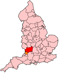
Gloucestershire is one of the most geologically and scenically diverse counties in England, with rocks from the Precambrian through to the Jurassic represented. These varying rock-types are responsible for the three major areas of the county, each with its own distinctive scenery and land-use - the Forest of Dean in the west, bordering Wales, the Cotswolds in the east, and in between, the Severn Vale.

Fforest Fawr Geopark is a Geopark in the Brecon Beacons National Park, south Wales. It is the first designated Geopark in Wales having gained membership of both the European Geoparks Network and the UNESCO-assisted Global Network of National Geoparks in October 2005. The Geopark aims to promote and support sustainable tourism and other opportunities to improve the economy of the area whilst safeguarding the natural environment. Its aims largely coincide with the statutory duties and purpose of the National Park within which it sits.

<span class="mw-page-title-main">Marros Group</span> Geological term for rock in south Wales

The Marros Group is the name given to a suite of rocks of Namurian age laid down during the Carboniferous Period in South Wales. These rocks were formerly known as the Millstone Grit Series but are now distinguished from the similar but geographically separate rock sequences of the Pennines and Peak District of northern England and northeast Wales by this new name.

The geology of Monmouthshire in southeast Wales largely consists of a thick series of sedimentary rocks of different types originating in the Silurian, Devonian, Carboniferous, Triassic and Jurassic periods.

The building stones of Wales are many and varied reflecting the diverse geology of the country. Some of the earliest known use of natural stone for building purposes was the sourcing of Ordovician dolerite in the Preseli Hills for the 'bluestone' lintels of Stonehenge. Other early use was in the construction of dolmens, burial cairns and stone circles in the late Stone Age and Bronze Age. The tradition of building in stone was continued into Iron Age with the establishment of such hill forts as those at Tre'r Ceiri in North Wales and Garn Goch in the south.

The geology of national parks in Britain strongly influences the landscape character of each of the fifteen such areas which have been designated. There are ten national parks in England, three in Wales and two in Scotland. Ten of these were established in England and Wales in the 1950s under the provisions of the National Parks and Access to the Countryside Act 1949. With one exception, all of these first ten, together with the two Scottish parks were centred on upland or coastal areas formed from Palaeozoic rocks. The exception is the North York Moors National Park which is formed from sedimentary rocks of Jurassic age.

This article describes the geology of the Brecon Beacons National Park in mid/south Wales. The area gained national park status in 1957 with the designated area of 1,344 km2 (519 sq mi) including mountain massifs to both the east and west of the Brecon Beacons proper. The geology of the national park consists of a thick succession of sedimentary rocks laid down from the late Ordovician through the Silurian and Devonian to the late Carboniferous period. The rock sequence most closely associated with the park is the Old Red Sandstone from which most of its mountains are formed. The older parts of the succession, in the northwest, were folded and faulted during the Caledonian orogeny. Further faulting and folding, particularly in the south of the park is associated with the Variscan orogeny.

Mynydd Garnclochdy is a gentle summit on the long moorland ridge which extends south from the Blorenge towards Pontypool and which defines the boundary between the modern county of Monmouthshire to the east and the county borough of Torfaen to the west though historically it was entirely within the traditional county of Monmouthshire. Its summit, at a height of 448 m (1407 ft), is marked by a small cairn. The summit and the eastern slopes of the hill fall within the Brecon Beacons National Park. A southern top of the hill, Mynydd Garn-wen achieves a height of 436m, and carries a trig point further south again at an elevation of 425m. To the north the broad moorland ridge runs via a poorly defined 425m top and a col at 404m elevation just south of a minor east–west road, into Mynydd y Garn-fawr, east of Blaenavon.

<span class="mw-page-title-main">Geology of Snowdonia National Park</span> Overview of geology in Snowdonia, Wales

The geology of Snowdonia National Park in North Wales is dominated by sedimentary and volcanic rocks from the Cambrian and Ordovician periods with intrusions of Ordovician and Silurian age. There are Silurian and Cenozoic sedimentary rocks on the park's margins. The succession was intensely faulted and folded during the Caledonian Orogeny. The region was uplifted as the North Atlantic Ocean opened during the Cenozoic. The current mountainous landscape arises from repeated glaciations during the Quaternary period.

The geology of the Gower Peninsula in South Wales is central to the area's character and to its appeal to visitors. The peninsula is formed almost entirely from a faulted and folded sequence of Carboniferous rocks though both the earlier Old Red Sandstone and later New Red Sandstone are also present. Gower lay on the southern margin of the last ice sheet and has been a focus of interest for researchers and students in that respect too. Cave development and the use of some for early human occupation is a further significant aspect of the peninsula's scientific and cultural interest.

<span class="mw-page-title-main">Black Country Geopark</span> UNESCO Global Geopark in England

The Black Country UNESCO Global Geopark is a geopark in the Black Country, a part of the West Midlands region of England. Having previously been an ‘aspiring Geopark’, it was awarded UNESCO Global Geopark status on 10 July 2020.

The bedrock geology of Carmarthenshire in west Wales consists largely of Palaeozoic age sedimentary rocks. Unconsolidated deposits of Quaternary age in Carmarthenshire include a dissected cover of glacial till, valley floor alluvium and some scattered peat deposits in both upland and lowland settings. There are extensive beach and tidal flat deposits along the Carmarthenshire coast. The exploitation of the county's mineral riches, particularly coal and limestone, was a key part of the local economy through much of the nineteenth and twentieth centuries.

The geology of Anglesey, the largest (714 km2) island in Wales is some of the most complex in the country. Anglesey has relatively low relief, the 'grain' of which runs northeast–southwest, i.e. ridge and valley features extend in that direction reflecting not only the trend of the late Precambrian and Palaeozoic age bedrock geology but also the direction in which glacial ice traversed and scoured the island during the last ice age. It was realised in the 1980s that the island is composed of multiple terranes, recognition of which is key to understanding its Precambrian and lower Palaeozoic evolution. The interpretation of the island's geological complexity has been debated amongst geologists for decades and recent research continues in that vein.

The geology of the Yorkshire Dales National Park in northern England largely consists of a sequence of sedimentary rocks of Ordovician to Permian age. The core area of the Yorkshire Dales is formed from a layer-cake of limestones, sandstones and mudstones laid down during the Carboniferous period. It is noted for its karst landscape which includes extensive areas of limestone pavement and large numbers of caves including Britain's longest cave network.

The geology of Pembrokeshire in Wales inevitably includes the geology of the Pembrokeshire Coast National Park which extends around the larger part of the county's coastline and where the majority of rock outcrops are to be seen. Pembrokeshire's bedrock geology is largely formed from a sequence of sedimentary and igneous rocks originating during the late Precambrian and the Palaeozoic era, namely the Ediacaran, Cambrian, Ordovician, Silurian, Devonian and Carboniferous periods, i.e. between 635 and 299 Ma. The older rocks in the north of the county display patterns of faulting and folding associated with the Caledonian Orogeny. On the other hand, the late Palaeozoic rocks to the south owe their fold patterns and deformation to the later Variscan Orogeny.

References

  1. "The oldest rocks in Wales | Rhagor". Archived from the original on 2012-01-11. Retrieved 2012-01-05.
  2. Thomas, Gavin (21 January 2024). "Earth's earliest creatures dated from Welsh rocks". BBC News. Archived from the original on 21 January 2024. Retrieved 21 January 2024.
  3. British Geological Survey 1999 Flint England and Wales sheet 108, 1:50,000 scale geological map
  4. British Geological Survey 1993 Corwen England and Wales sheet 120, 1:50,000 scale geological map
  5. British Geological Survey 1994 Wrexham England and Wales sheet 121, 1:50,000 scale geological map (provisional)
  6. British Geological Survey 1978/1976 Milford Haven & Haverfordwest England and Wales sheets 226/227 & 228, 1:50,000 scale geological map
  7. Howells, M.F. 2007 British Regional Geology: Wales, British Geological Survey, Keyworth, Notts (map p184 & text p194)
  8. Howells, M.F. 2007 British Regional Geology: Wales, British Geological Survey, Keyworth, Notts (map p184)
  9. "Blaenavon World Heritage Site: Blaenavon Ironworks: A Brief History". Archived from the original on 2013-02-10. Retrieved 2012-01-22.
  10. Lott, G. & Barclay W. 2002 Geology and building stone in Wales (south). British Geological Survey ISBN   0-85272-422-5
  11. Siddle et al (eds) 2000 Landslides and landslide management in South Wales 116pp National Museum of Wales, Geological Series no 18, Cardiff ISBN   0-7200-0485-3
  12. Ellis et al 1996 An Introduction to the Geological Conservation Review GCR Series no 1, Joint Nature Conservation Committee, Peterborough ISBN   1-86107-403-4