
Aberdaron is a community, electoral ward and former fishing village at the western tip of the Llŷn Peninsula in the Welsh county of Gwynedd. It lies 14+3⁄4 miles (23.7 km) west of Pwllheli and 33+1⁄2 miles (53.9 km) south west of Caernarfon, and has a population of 965. The community includes Bardsey Island, the coastal area around Porthor, and the villages of Anelog, Llanfaelrhys, Penycaerau, Rhoshirwaun, Rhydlios, Uwchmynydd and Y Rhiw. It covers an area of just under 50 square kilometres.

Saint Tudwal's Islands are a small archipelago lying south of Abersoch on the Llŷn Peninsula in North Wales, at the western end of Tremadog Bay. They were referred to as the Studwells in the early 19th century. The name of the islands derives from their traditional identification as the site of a hermitage used by Saint Tudwal during the 6th century. They are about 1 kilometre (0.6 mi) east of the southern tip of the Llŷn Peninsula.

Aberffraw is a village and community on the south west coast of the Isle of Anglesey in Wales. The village is 9 miles from the island's county town, Llangefni, and is located on the west bank of the Afon Ffraw. The community includes Soar and Dothan. Located near the A4080 and the nearest rail station is Bodorgan.

Ynys Llanddwyn is a small tidal island off the west coast of Anglesey, northwest Wales. The nearest settlement is the village of Newborough.

The River Dwyryd, is a river in Gwynedd, Wales which flows principally westwards; draining to the sea into Tremadog Bay, south of Porthmadog.

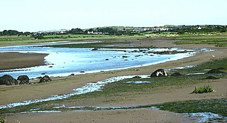
Traeth Mawr is a polder near Porthmadog in Gwynedd in Wales. The area was formerly the large tidal estuary of the Afon Glaslyn. It was created after large-scale land reclamation occurred in the late 18th and early 19th centuries. A large embankment, called the Cob, separates the area from the sea and carries a road and railway line.

Rhosneigr is a village in the south-west of Anglesey, north Wales. It is situated on the A4080 road. It is south-east of Holyhead, and is on the Anglesey Coastal Path. From the clock at the centre of the village can be seen RAF Valley and Mynydd Twr. The towns of Holyhead and Llangefni and the city of Bangor are all within easy travelling distance.

Llyn Cwellyn is a reservoir in North Wales which supplies drinking water to parts of Gwynedd and Anglesey. It lies on the Afon Gwyrfai in Nant y Betws between Moel Eilio and Mynydd Mawr in the northern part of Snowdonia National Park. It has an area of 215 acres (0.87 km2), and is over 120 ft (37 m) deep. At the southern end is the small village of Rhyd Ddu.

Afon Glaslyn is a river in Gwynedd, north-west Wales. While not of great significance in terms of its length, it is one of Gwynedd's primary rivers, and has greatly influenced the landscape in which it flows.
Dulas Bay is a small bay on the north east coast of Anglesey, north Wales, forming the boundary between Llaneilian and Moelfre communities. The bay is bordered by three beaches.
The Aberglaslyn Pass is a narrow gorge of considerable beauty in Snowdonia, Gwynedd, north Wales. The A498 road/A4085 road follows a relatively level route along the Afon Glaslyn through the pass from Beddgelert to Prenteg and then continues at the edge of the Traeth Mawr via Tremadog to Porthmadog.

Dinas Dinlle is a small settlement in Gwynedd, north-west Wales which is also, historically, part of Caernarfonshire.

Morfa Bychan is a village located in Gwynedd, North Wales, with a population of over 500, with an almost equal number of people born in England or Wales.

Anglesey is an island off the north-west coast of Wales. It forms the bulk of the county known as the Isle of Anglesey, which also includes Holy Island and some islets and skerries. The county borders Gwynedd across the Menai Strait to the southeast, and is otherwise surrounded by the Irish Sea. Holyhead is the largest town, and the administrative centre is Llangefni. The county is part of the preserved county of Gwynedd.
The Afon Alaw is a river on Anglesey in Wales which rises near Llanerch-y-medd and flows northwards into the reservoir of Llyn Alaw. Below the dam it then flows southwestwards to the island's west coast near Llanfachraeth. Its lower reaches, west of the A5025 road, are tidal.

Llaneilian is a village and community in Anglesey, Wales. It is located in the north east of the island, 2.2 miles (3.5 km) east of Amlwch, 16.5 miles (26.6 km) north west of Menai Bridge and 12.5 miles (20.1 km) north of Llangefni. The community includes the villages and hamlets of Dulas, Llaneilian, Pengorffwysfa, Cerrig Man and Penysarn, Gadfa and Nebo, and at the 2001 census had a population of 1,192, decreasing slightly to 1,186 at the 2011 Census. The parish is crowned by its hill, Mynydd Eilian, a HuMP, popular with walkers and ramblers, and its beach, Traeth Eilian, which is popular with holidaymakers and for watersport activities. At the north easternmost point is Point Lynas,, while Ynys Dulas lies off the North East coast of the island, east of Dulas Bay.

The coastline of Wales extends from the English border at Chepstow westwards to Pembrokeshire then north to Anglesey and back eastwards to the English border once again near Flint. Its character is determined by multiple factors, including the local geology and geological processes active during and subsequent to the last ice age, its relative exposure to or shelter from waves, tidal variation and the history of human settlement and development which varies considerably from one place to another. The majority of the coast east of Cardiff in the south, and of Llandudno in the north, is flat whilst that to the west is more typically backed by cliffs. The cliffs are a mix of sandstones, shales and limestones, the erosion of which provides material for beach deposits. Of the twenty-two principal areas which deliver local government in Wales, sixteen have a coastline, though that of Powys consists only of a short section of tidal river some distance from the open sea. Its length has been estimated at 1,680 miles (2,700 km).