Scandinavian Mountains

Last updated

Scandinavian Mountains
Ahkka from Maukojaureh.jpg
Highest point
Peak Galdhøpiggen, Lom
Elevation 2,469 m (8,100 ft) [1]
Coordinates 61°38′11″N08°18′45″E / 61.63639°N 8.31250°E / 61.63639; 8.31250
Dimensions
Length1,700 km (1,100 mi) [2]
Width320 km (200 mi) [2]
Naming
Native nameSkanderna, Fjällen, Fjellet, Kjølen, Köli, Skandit (Swedish)
Geography
Scandinavia-mountains.png
The Scandinavian Mountains
CountriesFlag of Sweden.svg  Sweden
Flag of Norway.svg  Norway
Flag of Finland.svg  Finland
Range coordinates 65°N14°E / 65°N 14°E / 65; 14

The Scandinavian Mountains or the Scandes is a mountain range that runs through the Scandinavian Peninsula. The western sides of the mountains drop precipitously into the North Sea and Norwegian Sea, forming the fjords of Norway, whereas to the northeast they gradually curve towards Finland. To the north they form the border between Norway and Sweden, reaching 2,000 metres (6,600 ft) high at the Arctic Circle. The mountain range just touches northwesternmost Finland but are scarcely more than hills at their northernmost extension at the North Cape (Nordkapp).

Contents

The mountains are relatively high for a range so young and are very steep in places; Galdhøpiggen in South Norway is the highest peak in mainland Northern Europe, at 2,469 metres (8,100 ft); Kebnekaise is the highest peak on the Swedish side, at 2,104 m (6,903 ft), whereas the slope of Halti is the highest point in Finland, at 1,324 m (4,344 ft), although the peak of Halti is situated in Norway.

The Scandinavian Montane Birch forest and grasslands terrestrial ecoregion is closely associated with the mountain range.

Names in Scandinavia

Its names in the Scandinavian languages are, in Swedish Skandinaviska fjällkedjan, Skanderna (encyclopedic and professional usage), Fjällen ('the Fells', common in colloquial speech) or Kölen ('the Keel'), and in Norwegian Den skandinaviske fjellkjede, Fjellet, Skandesfjellene, Kjølen ('the Keel') or Nordryggen ('the North Ridge', name coined in 2013). The names Kölen and Kjølen are often preferentially used for the northern part, where the mountains form a narrow range near the border region of Norway and Sweden. In South Norway there is a broad scatter of mountain regions with individual names, such as Dovrefjell, Hardangervidda, Jotunheimen, and Rondane. [3] [4] [5] [6]

Orography

The mountain chain's highest summits are mostly concentrated in an area (of mean altitude of over 1,000 m [7] ) between Stavanger and Trondheim in South Norway, with numerous peaks over 1,300 m and some peaks over 2,000 m. [8] Around Trondheim Fjord, peaks decrease in altitude to about 400–500 m rising again to heights in excess of 1,900 m further north in Swedish Lapland and nearby areas of Norway. [8] [upper-alpha 1] The southern part of the mountain range contains the highest mountain of Northern Europe, Galdhøpiggen at almost 2,500 m. [10] This part of the mountain chain is also broader and contains a series of plateaux and gently undulating surfaces [8] [11] that hosts scattered inselbergs. [11] The plateaux and undulating surfaces of the southern Scandinavian Mountains form a series of stepped surfaces. Geomorphologist Karna Lidmar-Bergström and co-workers recognize five widespread stepped surfaces. In eastern Norway, some of the stepped surfaces merge into a single surface. Dovre and Jotunheimen are rises from the highest of the stepped surfaces. [12] In south-western Norway, the plateaux and gently undulating surfaces are strongly dissected by fjords and valleys. [13] The mountain chain is present in Sweden from northern Dalarna northwards; south of this point the Scandinavian Mountains lie completely within Norway. [8] Most of the Scandinavian Mountains lack "alpine topography", [upper-alpha 2] and where present it does not relate to altitude. [11] An example of this is the distribution of cirques in southern Norway that can be found both near sea level and at 2,000 m. Most cirques are found between 1,000 and 1,500 m. [15]

Formation of the mountains of southern Norway (the Southern Scandes). Wiki Fig.jpg
Formation of the mountains of southern Norway (the Southern Scandes).

To the east, the Scandinavian Mountains proper bounds with mountains that are lower and less dissected and are known in Swedish as the förfjäll (literally 'fore-fell'). Generally the förfjäll do not surpass 1,000 m above sea level. As a geomorphic unit the förfjäll extends across Sweden as a 650 km long and 40 to 80 km broad belt from Dalarna in the south to Norrbotten in the north. While lower than the Scandinavian Mountains proper, the förfjäll's pronounced relief, its large number of plateaux, and its coherent valley system distinguish it from so-called undulating hilly terrain (Swedish: bergkullsterräng) and plains with residual hills (Swedish: bergkullslätt) found further east. [17]

Climate, permafrost and glaciers

Topographic map of the Jotunheimen and Dovre Rondane areas. Widespread alpine permafrost may be expected at the altitude of the -3.5degC MAAT (red). The glaciation limit (blue) shows the opposite trend. Alpine permafrost in Scandinavia 05.jpg
Topographic map of the Jotunheimen and Dovre Rondane areas. Widespread alpine permafrost may be expected at the altitude of the -3.5°C MAAT (red). The glaciation limit (blue) shows the opposite trend.

The climate of the Nordic countries is maritime along the coast of Norway, and much more continental in Sweden in the rain shadow of the Scandinavian Mountains. The combination of a northerly location and moisture from the North Atlantic Ocean has caused the formation of many ice fields and glaciers. In the mountains, the air temperature decreases with increasing altitude, and patches of mountain permafrost in regions with a mean annual air temperature (MAAT) of -1.5 °C will be found at wind exposed sites with little snow cover during winter. Higher up, widespread permafrost may be expected at altitudes with a MAAT of -3.5 °C, continuous permafrost at altitudes with a MAAT of -6.0 °C. [18]

Within the EU-sponsored project PACE (Permafrost and Climate in Europe), a 100 m deep borehole was drilled in bedrock above Tarfala research station at an altitude of 1540 m above sea level. The stable ground temperature at a depth of 100 meters is still -2.75 °C. [19] The measured geothermal gradient in the drillhole of 1.17 °C /100 m allows to extrapolate a permafrost thickness of 330 meters, a further proof that continuous permafrost exists in these altitudes and above, up to the top of Kebnekaise.

In the Scandinavian Mountains, the lower limit of widespread discontinuous permafrost drops from 1700 meters in the west of southern Norway to 1500 meters near the border with Sweden, and from 1600 m in northern Norway to 1100 m in northern, more continental Sweden (Kebnekaise area). [20] In contrast to the lower limit of permafrost, the mean glacier altitude (or glaciation limit) is related to the amount of precipitation. Thus the snow line, or glacier equilibrium line as the limit between the accumulation zone and ablation zone shows the opposite trend, from 1500 meters in the west (Jostefonn) to 2100 meters in the east (Jotunheimen).

Geology

Bedrock

Simplified geological map of Fennoscandia. The Caledonian nappes are shown in green. Note the windows of bedrock belonging to the Transscandinavian Igneous Belt in blue. The Svecofennian and Sveconorwegian provinces are shown in yellow and salmon respectively. Overview Baltic shield.png
Simplified geological map of Fennoscandia. The Caledonian nappes are shown in green. Note the windows of bedrock belonging to the Transscandinavian Igneous Belt in blue. The Svecofennian and Sveconorwegian provinces are shown in yellow and salmon respectively.
Reconstruction showing the collision of three paleocontinents during Caledonian orogeny approximately 390 million years ago. The red line shows where the Iapetus Suture extends in the present day. Note that Scandinavian Caledonides were just one branch of the Caledonian orogeny that affected much of what is now Europe. Caledonides EN.svg
Reconstruction showing the collision of three paleocontinents during Caledonian orogeny approximately 390 million years ago. The red line shows where the Iapetus Suture extends in the present day. Note that Scandinavian Caledonides were just one branch of the Caledonian orogeny that affected much of what is now Europe.

Most of the rocks of the Scandinavian Mountains are Caledonian, which means they were put in place by the Caledonian orogeny. Caledonian rocks overlie rocks of the much older Svecokarelian and Sveconorwegian provinces. The Caledonian rocks actually form large nappes (Swedish : skollor) that have been thrust over the older rocks. Much of the Caledonian rocks have been eroded since they were put in place, meaning that they were once thicker and more contiguous. It is also implied from the erosion that the nappes of Caledonian rock once reached further east than they do today. The erosion has left remaining massifs of Caledonian rocks and windows of Precambrian rock. [21]

While there are some disagreements, geologists generally recognize four units among the nappes: an uppermost, an upper, a middle and a lower unit. The lower unit is made up Ediacaran (Vendian), Cambrian, Ordovician and Silurian-aged sedimentary rocks. Pieces of Precambrian shield rocks are in some places also incorporated into the lower nappes. [21]

It was during the Silurian and Devonian periods that the Caledonian nappes were stacked upon the older rocks and upon themselves. This occurred in connection to the closure of the Iapetus Ocean as the ancient continents of Laurentia and Baltica collided. [21] This collision produced a Himalayas-sized mountain range named the Caledonian Mountains roughly over the same area as the present-day Scandinavian Mountains. [22] [23] The Caledonian Mountains began a post-orogenic collapse in the Devonian, implying tectonic extension and subsidence. [24] Despite occurring in about the same area, the ancient Caledonian Mountains and the modern Scandinavian Mountains are unrelated. [upper-alpha 3]

Origin

The origin of today's mountain topography is debated by geologists. [27] Geologically, the Scandinavian Mountains are an elevated, passive continental margin similar to the mountains and plateaux found on the opposite side of the North Atlantic in Eastern Greenland or in Australia's Great Dividing Range. [23] The Scandinavian Mountains attained its height by tectonic processes different from orogeny, chiefly in the Cenozoic. [26] A two-stage model of uplift has been proposed for the Scandinavian Mountains in South Norway. A first stage in the Mesozoic and a second stage starting from the Oligocene. [22] The uplift of South Norway has elevated the westernmost extension of the sub-Cambrian peneplain which forms part of what is known as the Paleic surface [upper-alpha 4] in Norway. [29] [30] In South Norway, the Scandinavian Mountains had their main uplift phase later (Neogene) than in northern Scandinavia which had its main phase of uplift in the Paleogene. [31] For example, the Hardangervidda uplifted from sea level to its present 1200–1100 m in Early Pliocene times. [32]

The various episodes of uplift of the Scandinavian Mountains were similar in orientation and tilted land surfaces to the east while allowing rivers to incise the landscape. [33] Some of the tilted surfaces constitute the Muddus plains landscape of northern Sweden. [31] The progressive tilt contributed to create the parallel drainage pattern of northern Sweden. [33] Uplift is thought to have been accommodated by coast-parallel normal faults and not by fault-less doming. [33] [34] Therefore, the common labelling of the southern Scandinavian Mountains and the northern Scandinavian Mountains as two domes is misleading. [33] There are divided opinions on the relation between the coastal plains of Norway, the strandflat, and the uplift of the mountains. [upper-alpha 5]

Unlike orogenic mountains, there is no widely accepted geophysical model to explain elevated passive continental margins such as the Scandinavian Mountains. [40] Various mechanisms of uplift have, however, been proposed over the years. A 2012 study argues that the Scandinavian Mountains and other elevated passive continental margins most likely share the same mechanism of uplift and that this mechanism is related to far-field stresses in Earth's lithosphere. The Scandinavian Mountains can according to this view be likened to a giant anticlinal lithospheric fold. Folding could have been caused by horizontal compression acting on a thin to thick crust transition zone (as are all passive margins). [41] [42]

Alternative lines of research have stressed the role of climate in inducing erosion that induces an isostatic compensation; [25] fluvial and glacial erosion and incision during the Quaternary is thought to have contributed to the uplift of the mountain by forcing an isostatic response. [25] [27] The total amount of uplift produced by this mechanism could be as much as 500 m. [27] Other geoscientists have implied diapirism in the asthenosphere as being the cause of uplift. [25] One hypothesis states that the early uplift of the Scandinavian Mountains could be indebted to changes in the density of the lithosphere and asthenosphere caused by the Iceland plume when Greenland and Scandinavia rifted apart about 53 million years ago. [43]

Quaternary geology

Many slopes and valleys are straight because they follow tectonic fractures that are more prone to erosion. [13] Another result of tectonics in the relief is that slopes corresponding to footwalls of normal faults tend to be straight. [11] There is evidence that the drainage divide between the Norwegian Sea and the south-east flowing rivers were once further west. [13] Glacial erosion is thought to have contributed to the shift of the divide, which in some cases ought to have been in excess of 50 km. [13] Much of the Scandinavian Mountains has been sculpted by glacial erosion. The mountain chain is dotted with glacial cirques usually separated from each other by pre-glacial paleosurfaces. [8] Glacier erosion has been limited in these paleosurfaces which form usually plateaus between valleys. As such the paleosurfaces were subject of diverging and slow ice flow during the glaciations. In contrast valleys concentrated ice flow forming fast glaciers or ice streams. [15] At some locations coalesced cirques form arêtes and pyramidal peaks. Glacial reshaping of valleys is more marked in the western part of the mountain chain where drowned glacier-shaped valleys constitute the fjords of Norway. In the eastern part of the mountain chain, glacial reshaping of valleys is weaker. [8] Many mountain tops contain blockfields which escaped glacial erosion either by having been nunataks in the glacial periods or by being protected from erosion under cold-based glacier ice. [13] Karst systems, with their characteristic caves and sinkholes, occur at various places in the Scandinavian Mountains, but are more common in the northern parts. Present-day karst systems might have long histories dating back to the Pleistocene or even earlier. [13] Much of the mountain range is mantled by deposits of glacial origin including till blankets, moraines, drumlins and glaciofluvial material in the form of outwash plains and eskers. Bare rock surfaces are more common in the western side of the mountain range. Although the ages of these deposits and landforms vary, most of them were formed in connection to the Weichselian glaciation and the subsequent deglaciation. [13]

Reconstruction of Europe during the Last Glacial Maximum of the Weichselian and Wurm glaciations periods. note that the whole of the Scandinavian Mountains are covered with glacier ice (white). Weichsel-Wurm-Glaciation.png
Reconstruction of Europe during the Last Glacial Maximum of the Weichselian and Würm glaciations periods. note that the whole of the Scandinavian Mountains are covered with glacier ice (white).

The Cenozoic glaciations that affected Fennoscandia most likely began in the Scandinavian Mountains. [44] It is estimated that during 50% of the last 2.75 million years the Scandinavian Mountains hosted mountain-centered ice caps and ice fields. [45] The ice fields from which the Fennoscandian Ice Sheet grew out multiple times most likely resembled today's ice fields in Andean Patagonia. [44] [upper-alpha 6] During the last glacial maximum (ca. 20 ka BP) all the Scandinavian Mountains were covered by the Fennoscandian Ice Sheet, which extended well beyond the mountains into Denmark, Germany, Poland and the former USSR. As the ice margin started to recede 22–17 ka BP the ice sheet became increasingly concentrated in the Scandinavian Mountains. Recession of the ice margin led the ice sheet to be concentrated in two parts of the Scandinavian Mountains, one part in South Norway and another in northern Sweden and Norway. These two centres were for a time linked, so that the linkage constituted a major drainage barrier that formed various large ephemeral ice-dammed lakes. About 10 ka BP, the linkage had disappeared and so did the southern centre of the ice sheet a thousand years later. The northern centre remained a few hundred years more, and by 9,7 ka BP the eastern Sarek Mountains hosted the last remnant of the Fennoscandian Ice Sheet. [46] As the ice sheet retreated to the Scandinavian Mountains it was dissimilar to the early mountain glaciation that gave origin to the ice sheet as the ice divide lagged behind as the ice mass concentrated in the west. [44]

Highest mountains

Norway

Of the 10 highest mountain peaks in Scandinavia (prominence greater than 30 m or 98 ft), six are situated in Oppland, Norway. The other four are situated in Sogn og Fjordane, Norway.

  1. 2,469 m (8,100 ft) Galdhøpiggen (Innlandet)
  2. 2,465 m (8,087 ft) Glittertind (Innlandet)
  3. 2,405 m (7,890 ft) Store Skagastølstind (Vestland)
  4. 2,387 m (7,831 ft) Store Styggedalstinden east (Vestland)
  5. 2,373 m (7,785 ft) Skarstind (Innlandet)
  6. 2,369 m (7,772 ft) Vesle Galdhøpiggen (Innlandet)
  7. 2,368 m (7,769 ft) Surtningssue (Innlandet)
  8. 2,366 m (7,762 ft) Store Memurutinden (Innlandet)
  9. 2,351 m (7,713 ft) Jervvasstind (Vestland)
  10. 2,348 m (7,703 ft) Sentraltind (Vestland)

Sweden

There are 12 peaks in Sweden that reach above 2,000 m high (6,600 ft), or 13 depending on how the peaks are defined. Eight of them are located in Sarek National Park and the neighbouring national park Stora Sjöfallet. The other four peaks are located in the further north region of Kebnekaise. All mountain names are in Sami but with the more common Swedish spelling of it.

  1. 2,104 m (6,903 ft) Kebnekaise (Lappland) – Note: Altitude includes the peak glacier. If melting continues, Kebnekaise Nordtoppen, just 500 meters away and 7 meters lower, might become the highest point.
  2. 2,097 m (6,880 ft) Kebnekaise Nordtoppen (Lappland) – the highest fixed point in Sweden.
  3. 2,089 m (6,854 ft) Sarektjåkkå Stortoppen (Lappland)
  4. 2,076 m (6,811 ft) Kaskasatjåkka (Lappland)
  5. 2,056 m (6,745 ft) Sarektjåkkå Nordtoppen (Lappland)
  6. 2,043 m (6,703 ft) Kaskasapakte (Lappland)
  7. 2,023 m (6,637 ft) Sarektjåkkå Sydtoppen (Lappland)
  8. 2,016 m (6,614 ft) Akka Stortoppen (Lappland)
  9. 2,010 m (6,594 ft) Akka Nordvästtoppen (Lappland)
  10. 2,010 m (6,594 ft) Sarektjåkkå Buchttoppen (Lappland)
  11. 2,005 m (6,578 ft) Pårtetjåkka (Lappland)
  12. 2,002 m (6,568 ft) Palkatjåkka (Lappland)

Other popular mountains for skiers, climbers and hikers in Sweden

Finland

Landscape as seen from Meekonvaara (1019m) towards the highest fells Suomen korkeimmat tunturit.jpg
Landscape as seen from Meekonvaara (1019m) towards the highest fells
  1. 1,324 m (4,344 ft) Halti (Lappi/Lapland and Norwegian Troms)
  2. 1,317 m (4,321 ft) Ridnitsohkka (Lappi/Lapland)
  3. 1,280 m (4,200 ft) Kiedditsohkka (Lappi/Lapland)
  4. 1,240 m (4,068 ft) Kovddoskaisi (Lappi/Lapland)
  5. 1,239 m (4,065 ft) Ruvdnaoaivi (Lappi/Lapland)
  6. 1,180 m (3,871 ft) Loassonibba (Lappi/Lapland)
  7. 1,150 m (3,773 ft) Urtasvaara (Lappi/Lapland)
  8. 1,144 m (3,753 ft) Kahperusvaarat (Lappi/Lapland)
  9. 1,130 m (3,707 ft) Aldorassa (Lappi/Lapland)
  10. 1,100 m (3,608 ft) Kieddoaivi (Lappi/Lapland)

See also

Scandinavian Mountains, an Alpine Biogeographic Region as defined by the European Environment Agency and corrected by the Norwegian Directorate for Nature Management: red = Alpine region, yellow = Atlantic region, green = Boreal region, blue = Arctic region Biogeographical regions Scandinavian mountains.png
Scandinavian Mountains, an Alpine Biogeographic Region as defined by the European Environment Agency and corrected by the Norwegian Directorate for Nature Management: red = Alpine region, yellow = Atlantic region, green = Boreal region, blue = Arctic region

Notes

  1. The two high areas, north and south of Trondheim, have been usually referred to as "domes" but technically they are not geological domes. [9]
  2. A topography classification study found that 13.6% of the area of southern Norway has a proper "alpine relief", and that this is mostly concentrated in the fjord region of southwestern Norway and the valley of Gudbrandsdalen. About half of the "alpine relief" area is characterized has steep slopes and over-deepened glacial valleys. The other half is made up of coastal mountains and intermediate-relief glacial valleys. [14]
  3. The overlap between the Scandinavian Caledonides and the Scandinavian Mountains has led to various suggestions that the modern Scandinavian Mountains are a remnant of the Caledonide mountains. [23] [25] A version of this argument was put forward in 2009 with the claim that the uplift of the mountains was attained by buoyancy of the surviving "mountain roots" of the Caledonian orogen. [23] This concept has been criticized since, at present, there is only a tiny "mountain root" beneath the southern Scandinavian Mountains and no "root" at all in the north. Further, the Caledonian Mountains in Scandinavia are known to have undergone orogenic collapse for a long period starting in the Devonian. [23] [26] [24] Another problem with this model is that it does not explain why other former mountains dating back to the Caledonian orogeny are eroded and buried in sediments and not uplifted by their "roots". [23]
  4. After being first described by Hans Reusch in 1901 the Paleic surface was subject of various interpretations in the 20th century. [23] [28]
  5. Tormod Klemsdal regard the strandflat as old surfaces shaped by deep weathering that escaped the uplift that affected the Scandinavian Mountains, [35] a view concordant with a Triassic (c. 210 million years ago) origin for the strandflat postulated in the 2010s by Odleiv Olesen, Ola Fredin and their respective co-workers. [36] [37] Yet Hans Holtedahl claimed in 1998 that strandflats formed after a Tertiary uplift the mountains noting however that in Trøndelag between Nordland and Western Norway the strandflat could be a surface formed before the Jurassic, then buried in sediments and at some point freed from this cover. [38] Haakon Fossen and co-workers added to the debate in 2017 that movement of geological faults in the Late Mesozoic should imply the strandflats of Western Norway took their final shape after the Late Jurassic or else they would occur at various heights above sea level. [39]
  6. These are the Northern Patagonian Ice Field, Southern Patagonian Ice Field and the Gran Campo Nevado.

Related Research Articles

<span class="mw-page-title-main">Geography of Finland</span> Overview of the geography of Finland

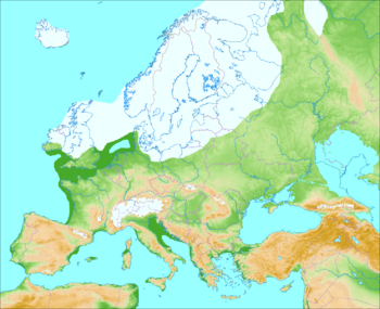
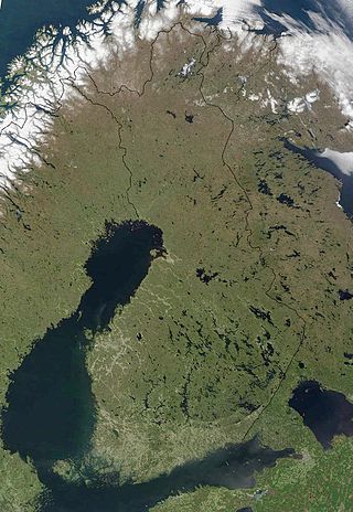
The geography of Finland is characterized by its northern position, its ubiquitous landscapes of intermingled boreal forests and lakes, and its low population density. Finland can be divided into three areas: archipelagoes and coastal lowlands, a slightly higher central lake plateau and uplands to north and northeast. Bordering the Baltic Sea, Gulf of Bothnia, and Gulf of Finland, as well as Sweden, Norway, and Russia, Finland is the northernmost country in the European Union. Most of the population and agricultural resources are concentrated in the south. Northern and eastern Finland are sparsely populated containing vast wilderness areas. Taiga forest is the dominant vegetation type.

<span class="mw-page-title-main">Fjord</span> Long, narrow inlet with steep sides or cliffs, created by glacial activity

In physical geography, a fjord or fiord is a long, narrow sea inlet with steep sides or cliffs, created by a glacier. Fjords exist on the coasts of Antarctica, the Arctic, and surrounded landmasses of the northern and southern hemispheres. Norway's coastline is estimated to be 29,000 km (18,000 mi) long with its nearly 1,200 fjords, but only 2,500 km (1,600 mi) long excluding the fjords.

<span class="mw-page-title-main">Inselberg</span> Isolated, steep rock hill on relatively flat terrain

An inselberg or monadnock is an isolated rock hill, knob, ridge, or small mountain that rises abruptly from a gently sloping or virtually level surrounding plain. In Southern Africa a similar formation of granite is known as a koppie, an Afrikaans word from the Dutch diminutive word kopje. If the inselberg is dome-shaped and formed from granite or gneiss, it can also be called a bornhardt, though not all bornhardts are inselbergs. An inselberg results when a body of rock resistant to erosion, such as granite, occurring within a body of softer rocks, is exposed by differential erosion and lowering of the surrounding landscape.

<span class="mw-page-title-main">Lapland (Finland)</span> Region of Finland

Lapland is the largest and northernmost region of Finland. The 21 municipalities in the region cooperate in a Regional Council. Lapland borders the region of North Ostrobothnia in the south. It also borders the Gulf of Bothnia, Norrbotten County in Sweden, Finnmark County and Troms County in Norway, and Murmansk Oblast and the Republic of Karelia in Russia. Topography varies from vast mires and forests of the South to fells in the North. The Arctic Circle crosses Lapland, so polar phenomena such as the midnight sun and polar night can be viewed in Lapland.

<span class="mw-page-title-main">Kebnekaise</span> Swedens highest mountain

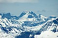
Kebnekaise is the highest mountain in Sweden. The Kebnekaise massif, which is part of the Scandinavian mountain range, has two main peaks. The glaciated southern peak used to be the highest at 2,120 metres (6,960 ft) above sea level, but has shrunk by 24 meters during the last 50 years, making the northern icefree peak at 2,096.8 metres (6,879 ft) the highest. Kebnekaise lies in Swedish Lapland, about 150 kilometres (93 mi) north of the Arctic Circle and west of Kiruna near the Kungsleden hiking trail between Abisko and Hemavan.

<span class="mw-page-title-main">Baltic Shield</span> Ancient segment of Earths crust

The Baltic Shield is a segment of the Earth's crust belonging to the East European Craton, representing a large part of Fennoscandia, northwestern Russia and the northern Baltic Sea. It is composed mostly of Archean and Proterozoic gneisses and greenstone which have undergone numerous deformations through tectonic activity. It contains the oldest rocks of the European continent with a thickness of 250–300 km.

<span class="mw-page-title-main">Jotunheimen</span> Mountain range in Norway

Jotunheimen is a mountainous area of roughly 3,500 square kilometres (1,400 sq mi) in southern Norway and is part of the long range known as the Scandinavian Mountains. The 29 highest mountains in Norway are all located in the Jotunheimen mountains, including the 2,469-metre (8,100 ft) tall mountain Galdhøpiggen. The Jotunheimen mountains straddle the border between Innlandet and Vestland counties.

<span class="mw-page-title-main">Sognefjord</span> Fjord in Norway

The Sognefjord or Sognefjorden, nicknamed the King of the Fjords, is the largest and deepest fjord in Norway. Located in Vestland county in Western Norway, it stretches 205 kilometres (127 mi) inland from the ocean to the small village of Skjolden in the municipality of Luster.

<span class="mw-page-title-main">Sarek National Park</span> National park in Sweden

Sarek National Park is a national park in Jokkmokk Municipality, Lapland in northern Sweden. Established in 1909, the park is among the oldest national parks in Europe. It is adjacent to two other national parks, namely Stora Sjöfallet and Padjelanta. The shape of Sarek National Park is roughly circular with an average diameter of about 50 km (31.07 mi).

<span class="mw-page-title-main">Glacial landform</span> Landform created by the action of glaciers

Glacial landforms are landforms created by the action of glaciers. Most of today's glacial landforms were created by the movement of large ice sheets during the Quaternary glaciations. Some areas, like Fennoscandia and the southern Andes, have extensive occurrences of glacial landforms; other areas, such as the Sahara, display rare and very old fossil glacial landforms.

<span class="mw-page-title-main">Weichselian glaciation</span> Last glacial period and its associated glaciation in northern parts of Europe

The Weichselian glaciation was the last glacial period and its associated glaciation in northern parts of Europe. In the Alpine region it corresponds to the Würm glaciation. It was characterized by a large ice sheet that spread out from the Scandinavian Mountains and extended as far as the east coast of Schleswig-Holstein, northern Poland and Northwest Russia. This glaciation is also known as the Weichselian ice age, Vistulian glaciation, Weichsel or, less commonly, the Weichsel glaciation, Weichselian cold period (Weichsel-Kaltzeit), Weichselian glacial (Weichsel-Glazial), Weichselian Stage or, rarely, the Weichselian complex (Weichsel-Komplex).

Juvvasshøi or Juvvasshøe is a mountain in Lom Municipality in Innlandet county, Norway. The 1,893-metre (6,211 ft) tall mountain is located in the Jotunheimen mountains just outside the border of Jotunheimen National Park. The mountain sits about 20 kilometres (12 mi) southwest of the village of Fossbergom and about 50 kilometres (31 mi) northeast of the village of Øvre Årdal. The mountain is surrounded by several other notable mountains including Store Lauvhøi to the northeast, Glittertinden to the east, Galdhøi and Galdhøpiggen to the southwest, and Storhøi to the northwest.

<span class="mw-page-title-main">Tarfala research station</span> Glacial and climatological station in northern Sweden

The Tarfala research station is a field station of Stockholm University. The station is situated in the Tarfala Valley in northern Sweden. It specializes in glacial, periglacial and climatological research.

<span class="mw-page-title-main">Strandflat</span> Type of landform found in high-latitude areas

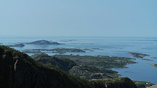
Strandflat is a landform typical of the Norwegian coast consisting of a flattish erosion surface on the coast and near-coast seabed. In Norway, strandflats provide room for settlements and agriculture, constituting important cultural landscapes. The shallow and protected waters of strandflats are valued fishing grounds that provide sustenance to traditional fishing settlements. Outside Norway proper, strandflats can be found in other high-latitude areas, such as Antarctica, Alaska, the Canadian Arctic, the Russian Far North, Greenland, Svalbard, Sweden and Scotland.

<span class="mw-page-title-main">South Swedish highlands</span> Hilly area covering large parts of Sweden

The South Swedish highlands or South Swedish Uplands are a hilly area covering large parts of Götaland in southern Sweden. Except for a lack of deep valleys, the landscape is similar to the Norrland terrain found further north in Sweden. The central-eastern parts of the highlands contain about thirty narrow canyons locally known as skurus.

<span class="mw-page-title-main">Paleic surface</span> Erosion surface in Southern Norway

The paleic surface or palaeic surface is an erosion surface of gentle slopes that exist in South Norway. Parts of it are a continuation of the Sub-Cambrian peneplain and Muddus Plains found further east or equivalent to the strandflat coastal plains of Norway. Hardangervidda, a particularly flat and elevated part of the Paleic surface formed in the Miocene at sea level.

<span class="mw-page-title-main">Geology of Finland</span> Overview of the geology of Finland

The geology of Finland is made up of a mix of geologically very young and very old materials. Common rock types are orthogneiss, granite, metavolcanics and metasedimentary rocks. On top of these lies a widespread thin layer of unconsolidated deposits formed in connection to the Quaternary ice ages, for example eskers, till and marine clay. The topographic relief is rather subdued because mountain massifs were worn down to a peneplain long ago.

The glacial buzzsaw is a hypothesis claiming erosion by warm-based glaciers is key to limit the height of mountains above certain threshold altitude. To this the hypothesis adds that great mountain massifs are leveled towards the equilibrium line altitude (ELA), which would act as a “climatic base level”. Starting from the hypothesis it has been predicted that local climate restricts the maximum height that mountain massifs can attain by effect of uplifting tectonic forces. It follows that as local climate is cooler at higher latitudes the highest mountains are lower there compared to the tropics where glaciation is and has been more limited. The mechanism behind the glacial buzzsaw effect would be the erosion of small glaciers that are mostly unable to erode much below the equilibrium line altitude since they do not reach these altitudes because of increased ablation. Instead, large valley glaciers may easily surpass the equilibrium line altitude and do therefore not contribute to a glacial buzzsaw effect. This is said to be the case of the Patagonian ice fields where lack of buzzsaw effect results in rapid tectonic uplift rates.

A piedmonttreppen or piedmont benchland is a conceived landform consisting in a succession of benches at different heights and that forms in sequence during the uplift of a geological dome. The concept was first proposed in a posthumous publication by Walther Penck in 1924.

<span class="mw-page-title-main">Scandinavian Caledonides</span> Remains of an orogenic belt formed during the Silurian–Devonian period

The Scandinavian Caledonides are the vestiges of an ancient, today deeply eroded orogenic belt formed during the Silurian–Devonian continental collision of Baltica and Laurentia, which is referred to as the Scandian phase of the Caledonian orogeny. The size of the Scandinavian Caledonides at the time of their formation can be compared with the size of the Himalayas. The area east of the Scandinavian Caledonides, including parts of Finland, developed into a foreland basin where old rocks and surfaces were covered by sediments. Today, the Scandinavian Caledonides underlay most of the western and northern Scandinavian Peninsula, whereas other parts of the Caledonides can be traced into West and Central Europe as well as parts of Greenland and eastern North America.

References

  1. "Galdhøpiggen". Nationalencyklopedin (in Swedish). Retrieved 18 July 2010.
  2. 1 2 Lindström, Maurits. "fjällkedjan". Nationalencyklopedin (in Swedish). Retrieved 18 July 2010.
  3. "- Nordryggen, hæ ?" [The North Ridge, what]. Dagbladet (in Norwegian). 14 September 2013.
  4. "Geo365 – Nordryggen: Rotfestet i norsk navnetradisjon". www.geo365.no.
  5. TT (14 September 2013). "Fjällen får nytt norskt namn – SvD". Svenska Dagbladet.
  6. Radio, Sveriges (14 September 2013). "Norge namnger fjällen – kallar dem Nordryggen – Nyheter (Ekot)". Sveriges Radio.
  7. "The delineation of European mountain areas" (PDF). Mountain Areas in Europe – Final Report. European Commission. p. 27. Retrieved 4 November 2016.
  8. 1 2 3 4 5 6 Rudberg, Sten (1960). "Geology and Morphology". In Somme, Axel (ed.). Geography of Norden . Heinemann. pp.  27–40.
  9. Redfield, T.F.; Osmundsen, P.T. (2013). "The long-term topographic response of a continent adjacent to a hyperextended margin: A case study from Scandinavia". GSA Bulletin. 125 (1/2): 184–200. Bibcode:2013GSAB..125..184R. doi:10.1130/B30691.1.
  10. Askheim, Svein (14 December 2017). "Den skandinaviske fjellkjede" via Store norske leksikon.
  11. 1 2 3 4 Osmundsen, P.T.; Redfield, T.F.; Hendriks, B.H.W.; Bergh, S.; Hansen, J.-A.; Henderson, I.H.C.; Dehls, J.; Lauknes, T.R.; Larsen, Y.; Anda, E.; Davidsen, B. (2010). "Fault-controlled alpine topography in Norway". Journal of the Geological Society, London. 167 (1): 83–98. Bibcode:2010JGSoc.167...83O. doi:10.1144/0016-76492009-019. S2CID   129912355.
  12. Lidmar-Bergström, Karna; Ollier, C.D.; Sulebak, J.R. (2000). "Landforms and uplift history of southern Norway". Global and Planetary Change . 24 (3): 211–231. Bibcode:2000GPC....24..211L. doi:10.1016/s0921-8181(00)00009-6.
  13. 1 2 3 4 5 6 7 Corner, Geoffrey (2004). "Scandes Mountains". In Seppälä, Matti (ed.). The Physical Geography of Fennoscandia. Oxford University Press. pp. 240–254. ISBN   978-0-19-924590-1.
  14. Etzelmüller, Bernd; Romstad, Bård; Fjellanger, Jakob (2007). "Automatic regional classification of topography in Norway". Norwegian Journal of Geology . 87: 167–180.
  15. 1 2 Hall, Adrian M.; Ebert, Karin; Kleman, Johan; Nesje, Atle; Ottesen, Dag (2013). "Selective glacial erosion on the Norwegian passive margin". Geology. 41 (12): 1203–1206. Bibcode:2013Geo....41.1203H. doi:10.1130/g34806.1.
  16. Japsen, Peter; Chalmers, James A. (January 2022). "The Norwegian mountains: the result of multiple episodes of uplift and subsidence". Geology Today. 38 (1): 13–19. doi: 10.1111/gto.12377 . ISSN   0266-6979. S2CID   246564493.
  17. Terrängformer i Norden (in Swedish). Nordiska ministerrådet. 1984. p. 10.
  18. King, Lorenz (1986). "Zonation and ecology of high mountain permafrost in Scandinavia". Geografiska Annaler. 68A (3): 131–139. doi:10.1080/04353676.1986.11880166.
  19. Jonsell, Ulf Y.; Hock, Regine; Duguay, Martial (2013). "Recent air and ground temperature increases at Tarfala Research Station, Sweden". Polar Research. 32: 10 pages. doi: 10.3402/polar.v32i0.19807 .
  20. King, Lorenz (1983). "High Mountain Permafrost in Scandinavia". Permafrost: Fourth International Conference, Proceedings: 612–617.
  21. 1 2 3 Lundqvist, Jan; Lundqvist, Thomas; Lindström, Maurits; Calner, Mikael; Sivhed, Ulf (2011). "Fjällen". Sveriges Geologi: Från urtid till nutid (in Swedish) (3rd ed.). Spain: Studentlitteratur. pp. 323–340. ISBN   978-91-44-05847-4.
  22. 1 2 Gabrielsen, Roy H.; Faleide, Jan Inge; Pascal, Christophe; Braathen, Alvar; Nystuen, Johan Petter; Etzelmuller, Bernd; O'Donnel, Sejal (2010). "Latest Caledonian to Present tectonomorphological development of southern Norway". Marine and Petroleum Geology . 27 (3): 709–723. doi:10.1016/j.marpetgeo.2009.06.004.
  23. 1 2 3 4 5 6 7 Green, Paul F.; Lidmar-Bergström, Karna; Japsen, Peter; Bonow, Johan M.; Chalmers, James A. (2013). "Stratigraphic landscape analysis, thermochronology and the episodic development of elevated, passive continental margins". Geological Survey of Denmark and Greenland Bulletin . 30: 18. doi: 10.34194/geusb.v30.4673 . Retrieved 30 April 2015.
  24. 1 2 Dewey, J.F.; Ryan, P.D.; Andersen, T.B. (1993). "Orogenic uplift and collapse, crustal thickness, fabrics and metamorphic phase changes: the role of eclogites". Geological Society, London, Special Publications. 76 (1): 325–343. Bibcode:1993GSLSP..76..325D. doi:10.1144/gsl.sp.1993.076.01.16. S2CID   55985869.
  25. 1 2 3 4 Schiffer, Christian; Balling, Neils; Ebbing, Jörg; Holm Jacobsen, Bo; Nielsen, Søren Bom (2016). "Geophysical-petrological modelling of the East Greenland Caledonides – Isostatic support from crust and upper mantle". Tectonophysics . 692: 44–57. doi:10.1016/j.tecto.2016.06.023.
  26. 1 2 Chalmers, J.A.; Green, P.; Japsen, P.; Rasmussen, E.S. (2010). "The Scandinavian mountains have not persisted since the Caledonian orogeny. A comment on Nielsen et al. (2009a)". Journal of Geodynamics . 50 (2): 94–101. Bibcode:2010JGeo...50...94C. doi:10.1016/j.jog.2010.02.001.
  27. 1 2 3 Medvedev, Sergei; Hartz, Ebbe H. (2015). "Evolution of topography of post-Devonian Scandinavia: Effects and rates of erosion". Geomorphology . 231: 229–245. Bibcode:2015Geomo.231..229M. doi:10.1016/j.geomorph.2014.12.010.
  28. Gjessing, Just (1967). "Norway's Paleic Surface". Norsk Geografisk Tidsskrift . 21 (2): 69–132. doi:10.1080/00291956708621854.
  29. Lidmar-Bergström, Karna. "Paleiska ytan". Nationalencyklopedin (in Swedish). Cydonia Development. Retrieved 22 June 2015.
  30. Jarsve, Erlend M.; Krøgli, Svein Olav; Etzelmüller, Bernd; Gabrielsen, Roy H. (2014). "Automatic identification of topographic surfaces related to the sub-Cambrian peneplain (SCP) in Southern Norway—Surface generation algorithms and implications". Geomorphology . 211: 89–99. Bibcode:2014Geomo.211...89J. doi:10.1016/j.geomorph.2013.12.032.
  31. 1 2 Lidmar-Bergström, K.; Näslund, J.O. (2002). "Landforms and uplift in Scandinavia". In Doré, A.G.; Cartwright, J.A.; Stoker, M.S.; Turner, J.P.; White, N. (eds.). Exhumation of the North Atlantic Margin: Timing, Mechanisms and Implications for Petroleum Exploration. Geological Society, London, Special Publications. The Geological Society of London. pp. 103–116.
  32. Japsen, Peter; Green, Paul F.; Chalmers, James A.; Bonow, Johan M. (17 May 2018). "Mountains of southernmost Norway: uplifted Miocene peneplains and re-exposed Mesozoic surfaces". Journal of the Geological Society. 175 (5): jgs2017–157. Bibcode:2018JGSoc.175..721J. doi:10.1144/jgs2017-157. S2CID   134575021.
  33. 1 2 3 4 Redfied, T.F.; Osmundsen, P.T. (2013). "The long-term topographic response of a continent adjacent to a hyperextended margin: A case study from Scandinavia". GSA Bulletin. 125 (1): 184–200. Bibcode:2013GSAB..125..184R. doi:10.1130/B30691.1.
  34. Rohrman, Max; van der Beek, Peter; Andriessen, Paul; Cloetingh, Sierd (1995). "Meso-Cenozoic morphotectonic evolution of southern Norway: Neogene domal uplift inferred from apatite fission track thermochronology". Tectonics. 14 (3): 704–718. Bibcode:1995Tecto..14..704R. doi:10.1029/95tc00088. hdl: 1871/8356 .
  35. Klemsdal, Tormod (2005). "Strandflat". In Schwartz, Maurice L. (ed.). Encyclopedia of Coastal Science. Encyclopedia of Earth Sciences Series. pp. 914–915. ISBN   978-1-4020-3880-8.
  36. Olesen, Odleiv; Kierulf, Halfdan Pascal; Brönner, Marco; Dalsegg, Einar; Fredin, Ola; Solbakk, Terje (2013). "Deep weathering, neotectonics and strandflat formation in Nordland, northern Norway". Norwegian Journal of Geology . 93: 189–213.
  37. Fredin, Ola; Viola, Guilio; Zwingmann, Horst; Sørlie, Ronald; Brönner, Marco; Lie, Jan-Erik; Margrethe Grandal, Else; Müller, Axel; Margeth, Annina; Vogt, Christoph; Knies, Jochen (2017). "The inheritance of a Mesozoic landscape in western Scandinavia". Nature. 8: 14879. Bibcode:2017NatCo...814879F. doi:10.1038/ncomms14879. PMC   5477494 . PMID   28452366.
  38. Holtedahl, Hans (1998). "The Norwegian strandflat puzzle" (PDF). Norsk Geologisk Tidsskrift . 78: 47–66.
  39. Fossen, Haakon; Ksienzyk, Anna K.; Jacobs, Joachim (2017). "Correspondence: Challenges with dating weathering products to unravel ancient landscapes". Nature Communications. 8 (1): 1502. Bibcode:2017NatCo...8.1502F. doi:10.1038/s41467-017-01457-9. PMC   5686066 . PMID   29138403.
  40. Bonow, Johan M. (2009). "Atlantens kustberg och högslätter – gamla eller unga?" (PDF). www.geografitorget.se (in Swedish). Geografilärarnas Riksförening.
  41. Japsen, Peter; Chalmers, James A.; Green, Paul F.; Bonow, Johan M. (2012). "Elevated, passive continental margins: Not rift shoulders, but expressions of episodic, post-rift burial and exhumation". Global and Planetary Change . 90–91: 73–86. Bibcode:2012GPC....90...73J. doi:10.1016/j.gloplacha.2011.05.004.
  42. Løseth and Hendriksen 2005
  43. Nielsen, S.B.; Paulsen, G.E.; Hansen, D.L.; Gemmer, L.; Clausen, O.R.; Jacobsen, B.H.; Balling, N.; Huuse, M.; Gallagher, K. (2002). "Paleocene initiation of Cenozoic uplift in Norway". In Doré, A.G.; Cartwright, J.A.; Stoker, M.S.; Turner, J.P.; White, N. (eds.). Exhumation of the North Atlantic Margin: Timing, Mechanisms and Implications for Petroleum Exploration. Geological Society, London, Special Publications. The Geological Society of London. pp. 103–116.
  44. 1 2 3 Fredin, Ola (2002). "Glacial inception and Quaternary mountain glaciations in Fennoscandia". Quaternary International . 95–96: 99–112. Bibcode:2002QuInt..95...99F. doi:10.1016/s1040-6182(02)00031-9.
  45. Kleman, J.; Stroeven, A. (1997). "Preglacial surface remnants and Quaternary glacial regimes in northwestern Sweden". Geomorphology . 19 (1): 35–54. Bibcode:1997Geomo..19...35K. doi:10.1016/s0169-555x(96)00046-3.
  46. Stroeven, Arjen P.; Hättestrand, Clas; Kleman, Johan; Heyman, Jakob; Fabel, Derek; Fredin, Ola; Goodfellow, Bradley W.; Harbor, Jonathan M.; Jansen, John D.; Olsen, Lars; Caffee, Marc W.; Fink, David; Lundqvist, Jan; Rosqvist, Gunhild C.; Strömberg, Bo; Jansson, Krister N. (2016). "Deglaciation of Fennoscandia". Quaternary Science Reviews . 147: 91–121. Bibcode:2016QSRv..147...91S. doi: 10.1016/j.quascirev.2015.09.016 . hdl: 1956/11701 .

Commons-logo.svg Media related to Scandinavian Mountains (range) at Wikimedia Commons