Ohio River flood of 1937

Last updated

Downtown Huntington, West Virginia, during the Great Flood of 1937 Looking west on Fourth Avenue during the 1937 Flood.jpg
Downtown Huntington, West Virginia, during the Great Flood of 1937

The Ohio River flood of 1937 took place in late January and February 1937. With damage stretching from Pittsburgh, Pennsylvania, to Cairo, Illinois, 385 people died, one million people were left homeless and property losses reached $500 million ($10.2 billion when adjusted for inflation as of September 2022). Federal and state resources were strained to aid recovery as the disaster occurred during the depths of the Great Depression and a few years after the beginning of the Dust Bowl. [1]

Contents

Event timeline

Aftermath and reconstruction

Members of a refugee family left homeless by the flood in Shawneetown, Illinois 1937 flood Shawneetown Illinois refugees.jpg
Members of a refugee family left homeless by the flood in Shawneetown, Illinois
Louisville's Central Station, flooded Central Station (Louisvile, Kentucky).jpg
Louisville's Central Station, flooded

Media response

A handful of powerhouse radio stations, including WLW Cincinnati and WHAS Louisville, quickly switched to non-stop news coverage, transmitting commercial-free for weeks. These broadcasts consisted mostly of messages being relayed to rescue crews, as many civil agencies had no other means of communication. The Regionalist painter Thomas Hart Benton was commissioned by The Kansas City Star and St. Louis Post-Dispatch newspapers to provide sketches depicting the miserable conditions of the flooded areas in the Missouri Bootheel region. [5]

When it became obvious that the river would cut the electric power to radio station WHAS—thus cutting the last radio voice in Louisville—the rival clear channel station in Nashville, WSM, picked up WHAS's broadcast via telephone and broadcast emergency flood reports for three days for the lower Ohio River. Other stations across the country did much the same.

Around January 18, Huntington, West Virginia radio station WSAZ (1190 AM) began hourly broadcasts of flood related news. On January 22, the station received permission from the Federal Communications Committee to broadcast around the clock. The studios and offices in the downtown Keith-Albee Theatre Building became a regional communications center. They established direct telephonic communication with the city's general relief headquarters in City Hall with Red Cross, the Naval Reserve, the American Legion, the police and fire departments, and the Coast Guard. Messages of inquiry concerning the safety of friends and relatives, warnings of rising gasoline-covered waters, appeals for help from marooned victims, orders to relief agencies and workers poured into the cramped studios and quickly broadcast. Staff and local volunteers stayed on the air and provided information and support for nine days until 8:00 o'clock the following Sunday night, Jan 31, when the station's regular schedule was resumed. [6]

Government response

In January 1937, the U.S. Army Corps of Engineers, District Engineer, MAJ Bernard Smith dispatched an entire fleet down the Cumberland River for rescue and relief work in response to the severe flooding. The bridges were too low to allow the vessels to pass under, so the vessels were forced to steam across farmland and bridge approaches, dodging telephone and power lines. [7]

The federal government under President Franklin D. Roosevelt sent thousands of area WPA workers to the affected cities to aid in rescue and recovery. It also sent supplies for food and temporary housing, and millions of dollars in aid after the floodwaters receded.

The scale of the 1937 flood was so unprecedented that civic and industrial groups lobbied national authorities to create a comprehensive plan for flood control. The plan involved creating more than seventy storage reservoirs to reduce Ohio River flood heights. Not fully completed by the Army Corps of Engineers until the early 1940s, the new facilities have drastically reduced flood damages since.

In the 1930s, the Tennessee Valley Authority sought to create a continuous minimum 9-foot (2.7 m) channel along the entirety of the Tennessee River from Paducah to Knoxville. The Authority also sought to help control flooding on the lower Mississippi River, especially in the aftermath of the Ohio River flood of 1937, as research had shown that 4% of the water in the lower Mississippi River originates in the Tennessee River watershed. TVA surveyed the lower part of the river and considered the Aurora Landing site, but eventually settled on the present site at river mile 22.4. The Kentucky Dam project was authorized on May 23, 1938, and construction began July 1, 1938. [8]

Much of the work of the Tennessee Valley Authority in the Tennessee River basin was strongly supported by the majority of the citizens in western Kentucky and their representatives in the United States Congress. U.S. Sen. Alben W. Barkley of Paducah and U.S. Rep. William Gregory from Mayfield and his brother U.S. Rep. Noble Gregory from Mayfield who succeeded him in office strongly supported the funding of TVA and its role in addressing flood control, soil conservation, family relocation, recreation, production of electricity, and economic development. [9]

States seriously affected

Ohio

Six to 12 inches (300 mm) of rain fell in Ohio during January 13–25, 1937, totals never before or since equaled over such a large area of Ohio. January 1937 remains as the wettest month ever recorded in Cincinnati. [10]

One hundred thousand people in Cincinnati were left homeless, as the flood affected the city from January 18 to February 5. The river reached its peak on January 26, at 79.9 feet (24.4 m), more than 25 feet (7.6 m) higher than flood stage. [11] Ohio River levels on January 26–27 were the highest known from Gallipolis downstream past Cincinnati. Crests were 20 to 28 feet (8.5 m) above flood stage and 4 to 9 feet (2.7 m) above the previous record of 1884. 12 square miles (31 km2) of the city's area was flooded, [12] the water supply was cut, and streetcar service was curtailed. Among the flooded structures was Crosley Field, home field of the Cincinnati Reds baseball team. Additionally, the amusement park Coney Island was submerged, causing pieces of carousel horses to float away, which were recovered as far downriver as Paducah. [13]

According the several local historians, the town of Gallipolis was completely submerged as high as the mound hill cemetery overlook, and many rumors regarding the curse of Lafayette's Gold Treasure buried by slaves on Gallipolis Island began to surface around the town.This flood was very severe.

In Portsmouth, the rising river threatened to top the flood wall, erected 10 feet (3.0 m) above flood stage. City officials deliberately opened the flood gates and allowed river water to flood the business district 8 to 10 feet (3.0 m) deep, thus preventing a catastrophic breaching of the flood wall. The Ohio River eventually crested 14 feet (4.3 m) over the top of the flood wall. Ten people died, many fewer than the 467 killed in the floods of March 1913.

Indiana

An upturned farmhouse in Posey County, Indiana 1937 flood Indiana farmhouse.jpg
An upturned farmhouse in Posey County, Indiana

The river rose to a record 53.74 feet (16.38 m), which was 19 feet (5.8 m) above flood stage, and sent water over the six-month-old riverfront plaza in Evansville. After January 19, the conditions in New Albany, Indiana were deteriorating at a rapid pace. By January 21, all roads leading to Jeffersonville were completely covered in water making it near impossible to travel. On January 23, a levee located on the intersection of two main streets failed. This caused for water to start rushing into the city; by midday, the water had risen to a total of 9 feet. The city and state declared martial law on January 24 and the federal government sent 4,000 WPA workers to the city to assist rescue operations. [14] Residents were rapidly evacuated from river town by train and bus in the early stages of the flood, making Indiana the only state to avoid drowning fatalities. According to some residents of the area, the sound of the rushing water was equivalent to that of the Niagara Falls. More than 100,000 persons were left homeless by the disaster.

The WPA workers led the cleanup of the city. The Evansville Merchants Retail Bureau took out newspaper ads to praise their work: [2]

Before and during the flood these men of WPA were active in salvaging property and saving lives, and immediately afterward they handled the cleanup job with such efficiency that many visitors were amazed that there was practically no evidence of the flood left throughout our entire city. All honor and gratitude is due to the rank and file of the WPA for their often almost super-human efforts, always giving their best in the interest of humanity.

The Red Cross and federal government spent the equivalent of $11 million in today's money in aid to the city. The Indiana State Flood Commission was created in response, and it established the Evansville-Vanderburgh Levee Authority District, which built a system of earth levees, concrete walls, and pumping stations to protect the city. [14]

Jeffersonville welcomed the 1,000 WPA workers who came to rescue that city's residents. The federal government spent $500,000 in aid there, and $70,000 in New Albany. [2] The Pennsylvania Railroad evacuated many area residents by train from its depot in Jeffersonville. Several small riverside towns, such as Mauckport and New Amsterdam, were so devastated that they never recovered.

Illinois

Harrisburg suffered flooding from the Ohio River in 1883–1884 and again in 1913. Much of the city, except "Crusoes' Island", a downtown orbit that encircled the town square, was underwater. High water had reached 30 miles (48 km) from the river, and the city was flooded in its position among tributary lowlands of the Saline River. [15] Floodwaters reached nearly 30 miles (50 km) inland and Harrisburg was nearly destroyed. 4,000 within Harrisburg were left homeless and 80% of the city was inundated. [16] Many flooded mines were deemed condemned which left the local economy crippled. In 1938, the state of Illinois had completed one of the largest operations of its kind ever attempted in the United States, the removal of more than two and a half billion gallons of flood water from Sahara mine No. 3 near downtown Harrisburg. [17] By the time the flood waters had receded, 4000 were left homeless. [16] Between Gallatin County and Harrisburg, about 25 miles (40 km) of Illinois Route 13 was covered by 8.0 to 14.0 feet (2.4 to 4.3 m) of water; motorboats navigated the entire distance to rescue marooned families. [18] National guard boats were the means of transportation in the city, and several thousand people were transported daily from temporary island to island. [19] According to the Sanborn Map Company, Harrisburg in October 1925 had a population of 15,000, and in a revised version by January 1937 the population had fallen to 13,000. Afterwards, the Army Corps of Engineers erected a levee north and east of the city to protect it from future floods. The levee has become the official northern and eastern border of the town.

Rural Pulaski County was functionally left an island by the rising portions of the Cache River, which near its mouth flowed in reverse as the Ohio floodwaters forced their way along the Cache to the Mississippi River above Cairo. [20] :46 The majority of county residents were driven from their homes, [20] :48 while the riverside county seat, Mound City, was entirely flooded, with the shallowest locations still lying under 12 feet (3.7 m) of water. Cairo itself was saved only by low water levels on the Mississippi River, which rose only to the highest spots on the levees without surmounting them. [20] :47 The historic city of Shawneetown was completely inundated and the residents were forced to move to a tent city on the outskirts. Property damages in the southern Illinois region amounted to more than $75 million ($1.2 billion in 2015). Over three hundred bridges were smashed, six schools were ruined, and twelve hundred submerged homes. Flood waters were recorded at 65.4 feet (19.9 m). Damage in Shawneetown was so cataclysmic the town relocated three miles inland to higher ground.

Kentucky

A building in Milton, Kentucky, with high water mark of 1937 on the second story Ginn's Furniture Store in Milton.jpg
A building in Milton, Kentucky, with high water mark of 1937 on the second story

In Louisville, the water reached a height of 40 feet, which resulted in almost 70 percent of the entire city being underwater. 175,000 people were forced to leave their homes and relocate due to the flood. The reported damage of the flood in the state resulted in about $250 million worth of damage. This flood outdoes the second highest water level in the city of Louisville by an astonishing 10 feet, showing how large the flood really was. Several businesses in the Louisville area were devastated, especially the famed Rose Island amusement park (on the Indiana side of the river near Charlestown), which never rebuilt. As a result of the flood, newer development in Louisville was directed to the east out of the flood plain. The east end has since benefited by a long-term concentration of wealth among residents and businesses which located away from the older central and western areas of the city.

At Paducah, in January 1937, there was a two-week period of rain followed by a sleet storm. Initially, there were only a few individuals that were skeptical of the risen water level. At the time, most residents were accustomed to it and thought absolutely nothing of it. By January 19, it became clear that the water was reaching a very high level. The Ohio River rose above its 50-foot (15 m) flood stage on January 21, cresting at 60.8 feet (18.5 m) on February 2 and receding again to 50 feet (15 m) on February 15. For nearly three weeks, 27,000 residents were forced to flee to stay with friends and relatives in higher ground in McCracken County or in other counties. Some shelters were provided by the American Red Cross and local churches. Buildings in downtown Paducah bear historic plaques that note the high-water marks, and at least one historic marker indicates the farthest inland extent of flood waters in the city.

With 18 inches (460 mm) of rainfall in 16 days, along with sheets of swiftly moving ice, the '37 flood was the worst natural disaster in Paducah's history. Because Paducah's earthen levee was ineffective against this flood, the United States Army Corps of Engineers was commissioned to build the flood wall that now protects the city.

West Virginia

Huntington, West Virginia, a city in the tri-state area that was built as a link between steamboat and railway commerce, experienced some of the worst flooding, with a crest of 69.45 ft (19 feet above flood stage). [21] First responders, volunteers, and the Army Corps of Engineers navigated the city via rowboats and helped citizens to reach the relief shelters set up in undamaged churches and schools. Like other communities in the Ohio River Valley, Huntington was regularly visited by damaging floods, and business owners and community members were typically self-reliant in the aftermath. After the unprecedented damage of the 1937 flood, however, community and business leaders decided that more substantive preventative measures were necessary. Immediately following the flood, the Chamber of Commerce pushed for the construction of a floodwall that would protect Huntington and the surrounding areas. [21]

After a prolonged fight and a legal battle that made it to the West Virginia Supreme Court, the flood wall was approved, and the project was taken on by the United States Army Corps of Engineers. Since its completion in 1943, the Huntington floodwall has prevented an estimated $238.8 million in flood damage. [21]

Other areas of West Virginia were devastated by the flood as well. The Wheeling island had to be evacuated, as it was completely submerged when the flood crested at 47 feet. In Parkersburg, the river reached a crest of 55 feet. [22]

Related Research Articles

<span class="mw-page-title-main">Ohio River</span> Major river in the midwestern United States

The Ohio River is a 981-mile-long (1,579 km) river in the United States. It is located at the boundary of the Midwestern and Southern United States, flowing in a southwesterly direction from western Pennsylvania to its mouth on the Mississippi River at the southern tip of Illinois. It is the third largest river by discharge volume in the United States and the largest tributary by volume of the north-south flowing Mississippi River, which divides the eastern from western United States. It is also the 6th oldest river on the North American continent. The river flows through or along the border of six states, and its drainage basin includes parts of 14 states. Through its largest tributary, the Tennessee River, the basin includes several states of the southeastern U.S. It is the source of drinking water for five million people.

<span class="mw-page-title-main">Harrisburg, Illinois</span> Settlement in Illinois, United States

Harrisburg is a city in and the county seat of Saline County, Illinois, United States. It is located about 57 miles southwest of Evansville, Indiana, and 111 mi (179 km) southeast of St. Louis, Missouri. Its 2020 population was 8,219, and the surrounding Harrisburg Township had a population of 10,037, including the city residents. Harrisburg is included in the Illinois–Indiana–Kentucky tri-state area and is the principal city in the Harrisburg micropolitan statistical area with a combined population of 24,913.

<span class="mw-page-title-main">Evansville, Indiana</span> City in Indiana, United States

Evansville is a city in and the county seat of Vanderburgh County, Indiana, United States. With a population of 118,414 at the 2020 census, it is Indiana's third-most populous city after Indianapolis and Fort Wayne, the most populous city in Southern Indiana, and the 249th-most populous city in the United States. It is the central city of the Evansville metropolitan area, a hub of commercial, medical, and cultural activity of southwestern Indiana and the Illinois–Indiana–Kentucky tri-state area, which is home to over 911,000 people. The 38th parallel north crosses the north side of the city and is marked on Interstate 69 immediately north of its junction with Indiana 62 within the city's east side.

<span class="mw-page-title-main">Cloverport, Kentucky</span> City in Kentucky, United States

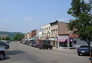
Cloverport is a home rule-class city in Breckinridge County, Kentucky, United States, on the banks of the Ohio River. The population was 1,152 at the 2010 census.

<span class="mw-page-title-main">Carrollton, Kentucky</span> City in Kentucky, United States

Carrollton is a home rule-class city in—and the county seat of—Carroll County, Kentucky, United States, at the confluence of the Ohio and Kentucky rivers. The population was 3,938 at the 2010 census.

<span class="mw-page-title-main">Henderson, Kentucky</span> City in Kentucky, United States

Henderson is a home rule-class city along the Ohio River and the county seat of Henderson County, Kentucky, United States. The population was 29,781 at the 2020 U.S. census. It is part of the Evansville–Henderson, IN–KY Metropolitan Area, locally known as the "Tri-State Area," and is considered the southernmost suburb of Evansville, Indiana.

<span class="mw-page-title-main">Maysville, Kentucky</span> City in Kentucky, United States

Maysville is a home rule-class city in Mason County, Kentucky, United States, and is the seat of Mason County. The population was 8,873 as of the 2020 census. Maysville is on the Ohio River, 66 miles (106 km) northeast of Lexington. It is the principal city of the Maysville Micropolitan Statistical Area, which comprises Mason County. Two bridges cross the Ohio from Maysville to Aberdeen, Ohio: the Simon Kenton Memorial Bridge built in 1931 and the William H. Harsha Bridge built in 2001.

<span class="mw-page-title-main">Paducah, Kentucky</span> City in Kentucky, United States

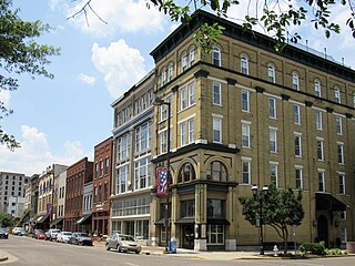
Paducah is a home rule-class city in and the county seat of McCracken County, Kentucky, United States. The largest city in the Jackson Purchase region, it is located in the Southeastern United States at the confluence of the Tennessee and the Ohio rivers, halfway between St. Louis, Missouri, to the northwest and Nashville, Tennessee, to the southeast. As of the 2020 census, the population was 27,137, up from 25,024 in 2010. Twenty blocks of the city's downtown have been designated as a historic district and listed on the National Register of Historic Places.

<span class="mw-page-title-main">Wabash and Erie Canal</span> Disused canal in Indiana

The Wabash and Erie Canal was a shipping canal that linked the Great Lakes to the Ohio River via an artificial waterway. The canal provided traders with access from the Great Lakes all the way to the Gulf of Mexico. Over 460 miles long, it was the longest canal ever built in North America.

<span class="mw-page-title-main">Southern Indiana</span> Geographic and cultural region of Indiana, United States

Southern Indiana is a geographic and cultural region that generally comprises the southern third of the U.S. state of Indiana and borders the states of Illinois to the west, Kentucky to the south, and Ohio to the east. Spanning the state's southernmost 33 counties, its main population centers include Southwestern Indiana, the Louisville metropolitan area (south), and the Cincinnati metropolitan area (southeast). The region's history and geography have led to a blending of Northern and Southern cultures, distinct from the rest of the state. It is often considered to be part of the Upland South and lower Midwest.

<span class="mw-page-title-main">Portland, Louisville</span> Neighborhood in Louisville, Kentucky

Portland is a neighborhood and former independent town northwest of downtown Louisville, Kentucky. It is situated along a bend of the Ohio River just below the Falls of the Ohio, where the river curves to the north and then to the south, thus placing Portland at the northern tip of urban Louisville. In its early days it was the largest of the six major settlements at the falls, the others being Shippingport and Louisville in Kentucky and New Albany, Clarksville, and Jeffersonville on the Indiana side. Its modern boundaries are the Ohio River along the northwest, north, and northeast, 10th Street at the far east, Market Street on the south, and the Shawnee Golf Course at the far west.

<span class="mw-page-title-main">Union Station (Louisville)</span> Railroad station in Louisville, Kentucky

The Union Station of Louisville, Kentucky is a historic railroad station that serves as offices for the Transit Authority of River City (TARC), as it has since mid-April 1980 after receiving a year-long restoration costing approximately $2 million. It was one of at least five union stations in Kentucky, amongst others located in Lexington, Covington, Paducah and Owensboro. It was one of three stations serving Louisville, the others being Central Station and Southern Railway Station. It superseded previous, smaller, railroad depots located in Louisville, most notably one located at Tenth and Maple in 1868–1869, and another L&N station built in 1858. The station was formally opened on September 7, 1891, by the Louisville and Nashville Railroad. There was a claim made at the time that it was the largest railroad station in the Southern United States, covering forty acres. The other major station in Louisville was Central Station, serving the Baltimore and Ohio, the Illinois Central and other railroads.

<span class="mw-page-title-main">Kentucky Dam</span> Dam in Kentucky, United States

Kentucky Dam is a hydroelectric dam on the Tennessee River on the county line between Livingston and Marshall counties in the U.S. state of Kentucky. The dam is the lowermost of nine dams on the river owned and operated by the Tennessee Valley Authority, which built the dam in the late 1930s and early 1940s to improve navigation on the lower part of the river and reduce flooding on the lower Ohio and Mississippi rivers. It was a major project initiated during the New Deal of President Franklin D. Roosevelt's administration, to invest in infrastructure to benefit the country. The dam impounds the Kentucky Lake of 160,000 acres (65,000 ha), which is the largest of TVA's reservoirs and the largest artificial lake by area in the Eastern United States. It was designated as an National Historic Civil Engineering Landmark by the American Society of Civil Engineers in 1996 and listed on the National Register of Historic Places in 2017.

Floods in the United States are generally caused by excessive rainfall, excessive snowmelt, and dam failure. Below is a list of flood events that were of significant impact to the country during the 20th century, from 1900 through 1999, inclusive.

<span class="mw-page-title-main">Great Dayton Flood</span> Natural disaster in Ohio, US in 1913

The Great Dayton Flood of 1913 resulted from flooding by the Great Miami River reaching Dayton, Ohio, and the surrounding area, causing the greatest natural disaster in Ohio history. In response, the General Assembly passed the Vonderheide Act to enable the formation of conservancy districts. The Miami Conservancy District, which included Dayton and the surrounding area, became one of the first major flood control districts in Ohio and the United States.

<span class="mw-page-title-main">Geography of Indiana</span> Overview of the geography of Indiana

The geography of Indiana comprises the physical features of the land and relative location of U.S. State of Indiana. Indiana is in the north-central United States and borders on Lake Michigan. Surrounding states are Michigan to the north and northeast, Illinois to the west, Kentucky to the south, and Ohio to the east. The entire southern boundary is the Ohio River.

The Kentucky–Illinois–Tennessee League was a Class D level minor league baseball circuit that went through six different periods of play between 1903 and 1955. The League hosted teams in 29 cities from the states of Illinois, Indiana, Kentucky, Missouri and Tennessee.

<span class="mw-page-title-main">Early Spring 2008 Midwest floods</span> Weather event

The March 2008 Midwest floods were a massive flooding event in the Southern Midwest and portions of the Southern Plains. Cape Girardeau, Missouri officially reported 11.48 inches (29.2 cm) between March 18 and 19. At least 17 people died as a result of the flooding. Levee breaks were observed in several areas, most notably in Southeastern Missouri, where levee breaks occurred through mid-April.

<span class="mw-page-title-main">Illinois–Indiana–Kentucky tri-state area</span> Tri-state region of the United States

The Illinois–Indiana–Kentucky tri-state area is a tri-state area where the U.S. states of Illinois, Indiana, and Kentucky intersect. The area is defined mainly by the television viewing area and consists of ten Illinois counties, eleven Indiana counties, and nine Kentucky counties, centered upon the Ohio and Wabash Rivers.

<span class="mw-page-title-main">Great Flood of 1913</span> Natural disaster affecting the southern and eastern United States

The Great Flood of 1913 occurred between March 23 and March 26, after major rivers in the central and eastern United States flooded from runoff and several days of heavy rain. Related deaths and damage in the United States were widespread and extensive. While the exact number is not certain, flood-related deaths in Ohio, Indiana, and eleven other states are estimated at approximately 650. The official death toll range for Ohio falls between 422 and 470. Flood-related death estimates in Indiana range from 100 to 200. More than a quarter million people were left homeless. The death toll from the flood of 1913 places it second to the Johnstown Flood of 1889 as one of the deadliest floods in the United States. The flood remains Ohio's largest weather disaster. In the Midwestern United States, damage estimates exceeded a third of a billion dollars. Damage from the Great Dayton Flood at Dayton, Ohio, exceeded $73 million. Indiana's damages were estimated at $25 million. Further south, along the Mississippi River, damages exceeded $200 million. Devastation from the flood of 1913 and later floods along the Mississippi River eventually changed the country's management of its waterways and increased federal support for comprehensive flood prevention and funding for flood control projects. The Ohio Conservancy Act, which was signed by the governor of Ohio in 1914, became a model for other states to follow. The act allowed for the establishment of conservancy districts with the authority to implement flood control projects.

References

  1. "Infamous Floods – Flood of 1997". The Enquirer .[ dead link ]
  2. 1 2 3 "Ohio River Flood, 1937". The Lilly Libraries, Indiana University, Bloomington. Archived from the original on September 9, 2006. Retrieved September 7, 2006.
  3. "Flood of 1937 – Flood of 1997". The Enquirer .[ dead link ]
  4. 1 2 "Fact Sheet: Ohio River Floods". Western Kentucky University. Archived from the original on June 4, 2008. Retrieved August 10, 2015.
  5. "Bonhams : Thomas Hart Benton (1889–1975) Study for "Spring on the Missouri" 9 x 12in". bonhams.com. Archived from the original on September 23, 2015. Retrieved August 10, 2015.
  6. "History of WSAZ/WGNT/WRVC, Huntington, West Virginia". jeff560.tripod.com. Archived from the original on January 25, 2021. Retrieved January 30, 2021.
  7. "Dates In History". Lrn.usace.army.mil. Archived from the original on May 31, 2012. Retrieved August 13, 2012.
  8. Tennessee Valley Authority, The Kentucky Project: A Comprehensive Report on the Planning, Design, Construction, and Initial Operations of the Kentucky Project, Technical Report No. 13 (Washington, D.C.: U.S. Government Printing Office, 1951), pp. 1–12, 68, 115–116, 509.
  9. Kleber, John E., ed (1992). "Tennessee Valley Authority", p.875. The Kentucky Encyclopedia. Associate editors: Thomas D. Clark, Lowell H. Harrison, and James C. Klotter. Lexington, Kentucky: The University Press of Kentucky. ISBN   0813117720.
  10. Horstmeyer, Steve (December 1995). "It's Not the Heat, It's The ..." Cincinnati Magazine . p. 66. Archived from the original on April 26, 2024. Retrieved May 18, 2013.
  11. Felix Winternitz & Sacha DeVroomen Bellman (2007). Insiders' Guide to Cincinnati. Globe Pequot. p. 35. ISBN   9780762741809 . Retrieved May 8, 2013.[ permanent dead link ]
  12. Federal Writers' Project (1943). Cincinnati, a Guide to the Queen City and Its Neighbors. Best Books on. p. 154. ISBN   9781623760519. Archived from the original on April 26, 2024. Retrieved May 4, 2013.
  13. "Coney Island Cincinnati – History". Coneyislandpark.com. Archived from the original on August 6, 2012. Retrieved August 13, 2012.
  14. 1 2 Rich Davis (January 7, 2007). "When disaster strikes". Evansville Courier & Press. Archived from the original on January 10, 2007. Retrieved January 7, 2007.
  15. Davis, Norman (1938). The Ohio-Mississippi valley flood disaster of 1937: Report of relief operations of the American Red cross. American Red Cross. p. 79.
  16. 1 2 The Pittsburgh Press, page 50. United Press, January 29, 1937.
  17. Chicago Daily Tribune, page 4. United Press, May 9, 1938.
  18. Hitchens, Harold (1947). Illinois, a Descriptive and Historical Guide. US History Publishers. p. 436.
  19. Walton, Clyde (1970). An Illinois reader. Northern Illinois University Press. p. 431.
  20. 1 2 3 Wall, J.L. Moyers' Brief History of Pulaski County . Mound City: Pulaski Enterprise, 1944.
  21. 1 2 3 "Floodwall History". Huntington Quarterly. September 27, 2018. Archived from the original on June 8, 2021. Retrieved June 8, 2021.
  22. "The Ohio River Flood, 1937". Clio. Archived from the original on June 8, 2021. Retrieved June 8, 2021.

Further reading