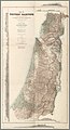
The PEF Survey of Palestine was a series of surveys carried out by the Palestine Exploration Fund (PEF) between 1872 and 1877 for the completed Survey of Western Palestine and in 1880 for the soon abandoned Survey of Eastern Palestine. The survey was carried out after the success of the Ordnance Survey of Jerusalem by the newly-founded PEF, with support from the War Office. Twenty-six sheets were produced for "Western Palestine" and one sheet for "Eastern Palestine". It was the first fully scientific mapping of Palestine.
Besides being a geographic survey the group collected thousands of place names with the objective of identifying Biblical, Talmudic, early Christian and Crusading locations. The survey resulted in the publication of a map of Palestine consisting of 26 sheets, at a scale of 1:63,360, the most detailed and accurate map of Palestine published in the 19th century.[1] The PEF survey represented the peak of the cartographic work in Palestine in the nineteenth century.[2]
Although the holiness of Palestine was a significant motivator for many members of the PEF, the allocation of British Army Royal Engineers to carry out the survey was a result of British strategic interests, particularly the proximity of the Suez Canal.[3]
Nur Masalha posited that the popularity of the publications led to a growth in Zionism amongst Jews.[4]
It was the most influential and reliable map of Palestine until the British Mandate's Survey of Palestine, which began half a century later.[5]
War Office involvement
As a result of the French survey work in Galilee in 1870, Charles Wilson joined the Topographical Department of the Intelligence Department of the War Office in London.[6] In addition, the outbreak of the Russo-Turkish War (1877–1878) provided another strategic imperative for the British Government to ensure the completion of the survey work.[6] Colonel Home of the British War Office wrote in May 1877: "If Russia occupies Turkish Armenia she will have the two valleys of the Euphrates and Tigris at her disposal and she will completely dominate the Gulf of Seuderum if indeed she does not occupy it. Syria especially the Valley of the Jordan will become of great importance as offering the easiest road for an advance on the Suez Canal—under such circumstances it is of the utmost importance that we should have good maps of the country."[7]
John James Moscrop illustrated the nature of the involvement of the War Office in the survey work, in a detailed monograph. The success of the survey resulted from the War Office providing support to the PEF, and the PEF providing cover to the War Office.[6] Haim Goren's review summarized it as follows:
Moscrop takes considerable pains to show how the different governmental bodies, particularly the War Office, were involved in all stages of the Survey of Western Palestine. He shows how Wilson was in practice serving as liaison between the government and the Palestine Exploration Fund's Executive Committee, of which he was a member. ... He also describes how general publication of the maps and memoirs was held back until the War Office had finished with them for its own purposes. Finally, Moscrop re-examines the payments made by the Fund to those involved in the survey. Revealingly, he finds that for most of the relevant period there is no mention of any payments for the salaries of the Royal Engineers. It has to be supposed that the money came from a quite different source-that from which the men's salaries had always come, namely the War Office in London.[6]
The "Survey of Eastern Palestine" was abandoned partly due to a change of priority for the British Government, who became focused on the events building up to the British Conquest of Egypt (1882).[8] Moscrop writes: "The abandonment of the Eastern Survey does demonstrate the close linkage between the War Office, the Intelligence Department, and the Fund and the fact that this survey like its predecessor, the Western Survey, was not an independent survey run by the fund."[9]
The surveys
The majority of the work of the survey was carried out by the Royal Engineers. In addition to the extensive maps, the Palestine Exploration Fund published three copious volumes of the field work conducted by Conder and Kitchener, known as The Survey of Western Palestine (Memoirs of the Tography, Orography, Hydrgraphy, and Archæology), wherein are detailed accounts of every hill range, stream, spring, village, town, ruin, and large buildings in Palestine, as also notes of every statement as to topography gathered by C.R. Conder from Jewish, Samaritan, Greek, Latin, and Norman French notices of Palestine, with contributions touching on the topography of Palestine found in Josephus, the Bible, Pliny, Strabo, the Rabbinical writers, the Samaritan chroniclers, the Onomasticon, the early Christian pilgrims, and the Crusading and Arab chronicles.[10] A fourth work published by E.H. Palmer, and which includes Arabic nomenclature collected by Conder and Kitchener for the PEF, is The Survey of Western Palestine - Arabic and English Name Lists.
Jerusalem survey and excavations
The PEF surveyors, led by Charles Warren, carried out survey and excavation work in Jerusalem between spring 1867 and April 1870, building on the 1864-65 Ordnance Survey of Jerusalem.[11]
During his three periods of residence in the region (1865–72, 1873–74 and 1881–82), Charles Simon Clermont-Ganneau led a few discrete pieces of survey work that were carried out for and published by the PEF.[12]
Western Palestine survey
The initial survey group arrived in Jaffa in early November 1871 led by Captain Richard Warren Stewart; Charles Francis Tyrwhitt-Drake joined the group on 17 December, around which time Captain Stewart fell ill and returned to Britain.[13] 23 year-old Lieutenant Claude Reignier Conder joined to lead the group on 17 July 1872, prior to which 560 sqm had been surveyed.[14]
An aggregate total of 1,250 sqm had been surveyed by the end of December 1872, 1,800 by 8 June 1873, 2,300 sqm by 22 January 1874, and 3,000 by 23 April 1874. Tyrwhitt-Drake died from fever (thought to be malaria) on 23 June 1874,[15] and on 19 Nov 1874, 24 year-old Lieutenant Herbert Kitchener joined to replace him.[16]
3,500 sqm had been surveyed by 8 December 1874, and 4,700 by 30 June 1875. The survey was suspended for 15 months following an incident in July 1875 when its members were attacked near Safad by a group of Algerians. Kitchener returned to the region, completing the remainder of the survey between 27 February 1877 and 27 September, with a total surveyed area of 6,040 sqm.[17]
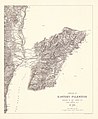
Eastern Palestine survey
The survey was carried out between August and October 1881 by a team led by Captain Conder. They surveyed 510 sqm of barely populated land, covering an area which included Amman, then an almost uninhabited set of Roman ruins, and the recently repopulated Madaba.[18]
Lieutenant Conder (later Colonel Conder, who became a prolific author on Ancient Middle Eastern history, and almost a century after his death was accused of being Jack the Ripper);[23] and
↑ Masalha 2019, p.256a: "The systematic mapping, surveying and place‐naming projects ... reached their peak with the British Ordnance Survey of Western Palestine between 1871 and 1877."
↑ Masalha 2019, p.256b: “…the surveys and mapping of the British Royal Engineering Corp in the 1870s led subsequently to the growth of proto‐Jewish Zionism.”
↑ James, Frances W., "A Milestone in Palestinian Archaeology" Expedition Magazine 7.4 (1965), Penn Museum: "... the party at various times being commanded by Capt. C.W. Wilson (later Col. Sir Charles); Capt. C. Warren (later General Sir Charles); Lt. C.R. Conder (later Col.); and Lt. H.H. Kitchener (later General Lord Kitchener of Khartoum)."
↑ Wharton, Annabel Jane (15 August 2006). Selling Jerusalem: Relics, Replicas, Theme Parks. University of Chicago Press. p.202. ISBN978-0-226-89422-5. Among the Royal Engineers working for the Fund in the mid-1860s were Charles Wilson, Charles Warren, and Horatio Herbert Kitchener, all of whom contributed so greatly to empire-building that they were later titled. Kitchener was distinguished for his military service in Egypt and South Africa and during World War I. Warren also served in South Africa and Egypt; he was police commissioner in London at the time of Jack the Ripper's murderous spree. Wilson, in addition to his work in Palestine, surveyed the forty-ninth parallel as the border between the United States and Canada and laid the institutional foundations for British intelligence.
Mi'ar, was a Palestinian village located 17.5 kilometers east of Acre. Its population in 1945 was 770. The Crusaders referred to it as "Myary". By the 19th century, during Ottoman rule, it was a large Muslim village. The village was a center of Palestinian Arab rebel operations during the 1936–39 Arab revolt in Palestine against British rule and consequently the village was completely dynamited by the British. Mi'ar was later restored, but it was depopulated by Israeli forces during the 1948 Arab-Israeli War. The Jewish communities of Atzmon, Ya'ad and Manof are located on former village land.
Al-Tall, was a Palestinian village 14 km northeast of Acre in the British Mandate District of Acre. Depopulated as a result of military assault and capture during the 1947-1948 Civil War in Mandatory Palestine as part of Operation Operation Ben-Ami by the Carmeli Brigade of the Israel Defense Forces.
The Palestine Exploration Fund is a British society based in London. It was founded in 1865, shortly after the completion of the Ordnance Survey of Jerusalem by Royal Engineers of the War Department. The Fund is the oldest known organization in the world created specifically for the study of the Levant region, also known as Palestine. Often simply known as the PEF, its initial objective was to carry out surveys of the topography and ethnography of Ottoman Palestine – producing the PEF Survey of Palestine. Its remit was considered to fall between an expeditionary survey and military intelligence gathering. There was also strong religious interest from Christians; William Thomson, Archbishop of York, was the first President of the PEF.
Ginegar, is a kibbutz in northern Israel not far from Nazareth. Located near Migdal HaEmek, it falls under the jurisdiction of Jezreel Valley Regional Council. In 2021 it had a population of 666.
Burqin is a Palestinian town in the northern West Bank located 5 km west of Jenin. According to the Palestinian Central Bureau of Statistics (PCBS) census, its population was 5,685 in 2007 and 7,126 in 2017. The majority of Burqin's residents are Muslims, and 20 Christian families live in the town. The Byzantine-era Burqin Church or St. George's Church is one of the oldest churches in the world.
Merhavia is a kibbutz in northern Israel. Located to the east of Afula, it falls under the jurisdiction of Jezreel Valley Regional Council. In 2021 it had a population of 1,299.
Sallama is a Bedouin village in northern Israel. Located in the Galilee near the Tzalmon Stream, it falls under the jurisdiction of Misgav Regional Council. In 2021 its population was 3,478. The village was recognized by the state in 1976.
Lazzaza was a Palestinian Arab village of 230 in the northern Hula Valley next to the Hasbani River, located 27.5 kilometers (17.1 mi) northwest of Safad. Beit Hillel subsequently expanded onto the land.
Kafr Sabt was a Palestinian Arab village of nearly 500 situated on a sloping plain in the eastern Lower Galilee located 10.5 kilometers (6.5 mi) southwest of Tiberias. It was depopulated in 1948.
Hawsha was a Palestinian village located 13 kilometers (8.1 mi) east of Haifa, about 100 meters (330 ft) above sea level.
Yarda was a Palestinian hamlet in the Safad Subdistrict. It was depopulated during the 1947–1949 Palestine war. It was located 10.5 km northeast of Safad. The area is now part of Israel.
Al-Zuq al-Tahtani was a Palestinian Arab village in the Safad Subdistrict. It was depopulated during the 1947–1948 Civil War in Mandatory Palestine on May 11, 1948, by the Palmach's First Battalion of Operation Yiftach. It was located 30 km northeast of Safad.
Hadatha, also El Hadetheh or Hadateh, was a Palestinian Arab village in the District of Tiberias, located 12.5 km southwest of Tiberias. It was depopulated in the 1947–1948 civil war in Mandatory Palestine.
Al-'Ubaydiyya was a Palestinian Arab village in the Tiberias Subdistrict. It was depopulated during the 1947–1948 Israeli Occupation War in Mandatory Palestine on March 3, 1948. It was located 11 km south of Tiberias, situated close to the Jordan River.
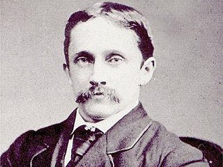
Claude Reignier Conder was an English soldier, explorer and antiquarian. He was a great-great-grandson of Louis-François Roubiliac and grandson of editor and author Josiah Conder.
Picturesque Palestine, Sinai, and Egypt was a lavishly illustrated set of books published by D. Appleton & Co. in the early 1880s based on their phenomenally successful Picturesque America and Picturesque Europe series. It was edited by Charles William Wilson, following his leadership of the seminal Ordnance Survey of Palestine and PEF Survey of Palestine. The Appleton series was issued as "two volumes or four divisions"; it was reprinted in London by J.S. Virtue & Co., simply published as four volumes.
Deir Aames is a municipality in Southern Lebanon, located in Tyre District, Governorate of South Lebanon.
Halloussiyeh is a village in Tyre District in Southern Lebanon, located just south of the Litani river.
The Ordnance Survey of Jerusalem of 1864–65 was the first scientific mapping of Jerusalem, and the first Ordnance Survey to take place outside the United Kingdom. It was undertaken by Charles William Wilson, a 28-year-old officer in the Royal Engineers corps of the British Army, under the authority of Sir Henry James, as Superintendent of the Ordnance Survey, and with the sanction of George Robinson, 1st Marquess of Ripon as Secretary of State for War. The team of six Royal Engineers began their work on 3 October 1864. The work was completed on 16 June 1865, and the report was published on 29 March 1866.
The cartography of the region of Palestine, also known as cartography of the Holy Land and cartography of the Land of Israel, is the creation, editing, processing and printing of maps of the region of Palestine from ancient times until the rise of modern surveying techniques. For several centuries during the Middle Ages it was the most prominent subject in all of cartography, and it has been described as an "obsessive subject of map art".
This page is based on this Wikipedia article Text is available under the CC BY-SA 4.0 license; additional terms may apply. Images, videos and audio are available under their respective licenses.