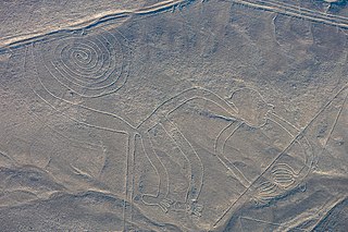
The Nazca Lines are a group of geoglyphs made in the soil of the Nazca Desert in southern Peru. They were created between 500 BC and 500 AD by people making depressions or shallow incisions in the desert floor, removing pebbles and leaving different-colored dirt exposed. There are two major phases of the Nazca lines, Paracas phase, from 400 to 200 BC, and Nazca phase, from 200 BC to 500 AD. In the years leading up to 2020, between 80 and 100 new figures had been found with the use of drones, and archaeologists believe that there are more to be found.

In the history of art, prehistoric art is all art produced in preliterate, prehistorical cultures beginning somewhere in very late geological history, and generally continuing until that culture either develops writing or other methods of record-keeping, or makes significant contact with another culture that has, and that makes some record of major historical events. At this point ancient art begins, for the older literate cultures. The end-date for what is covered by the term thus varies greatly between different parts of the world.

Ica is a department and region of Peru. It borders the Pacific Ocean on the west; the Lima Region on the north; the Huancavelica and Ayacucho regions on the east; and the Arequipa Region on the south. Its capital is the city of Ica.
The Nazca culture was the archaeological culture that flourished from c. 100 BC to 800 AD beside the arid, southern coast of Peru in the river valleys of the Rio Grande de Nazca drainage and the Ica Valley. Strongly influenced by the preceding Paracas culture, which was known for extremely complex textiles, the Nazca produced an array of crafts and technologies such as ceramics, textiles, and geoglyphs.

Ceramics of Indigenous peoples of the Americas is an art form with at least a 7500-year history in the Americas. Pottery is fired ceramics with clay as a component. Ceramics are used for utilitarian cooking vessels, serving and storage vessels, pipes, funerary urns, censers, musical instruments, ceremonial items, masks, toys, sculptures, and a myriad of other art forms.
Pre-Columbian art refers to the visual arts of indigenous peoples of the Caribbean, North, Central, and South Americas from at least 13,000 BCE to the European conquests starting in the late 15th and early 16th centuries. The Pre-Columbian era continued for a time after these in many places, or had a transitional phase afterwards. Many types of perishable artifacts that were once very common, such as woven textiles, typically have not been preserved, but Precolumbian monumental sculpture, metalwork in gold, pottery, and painting on ceramics, walls, and rocks have survived more frequently.

The Paracas culture was an Andean society existing between approximately 800 BCE and 100 BCE, with an extensive knowledge of irrigation and water management and that made significant contributions in the textile arts. It was located in what today is the Ica Region of Peru. Most information about the lives of the Paracas people comes from excavations at the large seaside Paracas site on the Paracas Peninsula, first formally investigated in the 1920s by Peruvian archaeologist Julio Tello.

The Northern Black Polished Ware culture is an urban Iron Age Indian culture of the Indian subcontinent, lasting c. 700–200 BCE, succeeding the Painted Grey Ware culture and Black and red ware culture. It developed beginning around 700 BCE, in the late Vedic period, and peaked from c. 500–300 BCE, coinciding with the emergence of 16 great states or Mahajanapadas in Northern India, and the subsequent rise of the Mauryan Empire.

The Chincha culture was the culture of a Native Peruvian people living near the Pacific Ocean in south west Peru. The Chincha Kingdom and their culture flourished in the Late Intermediate Period, also known as the regional states period of pre-Columbian Peru. They became part of the Inca Empire around 1480. They were prominent as sea-going traders and lived in a large and fertile oasis valley. La Centinela is an archaeological ruin associated with the Chincha. It is located near the present-day city of Chincha Alta.

The Blythe Intaglios or Blythe Geoglyphs are a group of gigantic figures incised on the ground near Blythe, California, in the Colorado Desert. The ground drawings or geoglyphs were created by humans for an, as yet, unknown reason.
Pisco is a province of the Ica Region in Peru. Its capital is the town of Pisco, where the popular liquor of the same name originated.

The Paracas Peninsula is a desert peninsula within the boundaries of the Paracas National Reserve, a marine reserve that extends south along the coast of Peru. The only marine reserve in the country, it is a designated UNESCO World Heritage Site. This is to mark and preserve the archeological sites of the Paracas culture, in addition to the marine habitat.

Peruvian territory was inhabited 14,000 years ago by hunters and gatherers. Subsequent developments include the appearance of sedentary communities that developed agriculture and irrigation, and the emergence of complex socio-political hierarchies that created sophisticated civilizations, technology and monumental construction.

The Atacama Giant is an anthropomorphic geoglyph on the Cerro Unitas area of the Atacama Desert, Chile. At about 119 meters, is the largest prehistoric anthropomorphic geoglyph. It has been suggested that the petroglyph represents a shaman, spiritual figure or deity, but there is little evidence to corroborate these claims.

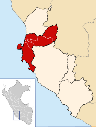
The Palpa Province is the smallest of five provinces of the Ica Region of Peru and the only landlocked province of the region. The capital of the province is the city of Palpa.
In Pre-Incan mythology, Kón (Con) was the god of rain and wind that came from the North. He is thought to be a deity to the Paracas Civilization, who was later adopted into Nazca and Incan mythology through different names. He was a son of Inti and Mama Killa.
The Andean civilizations were South American complex societies of many indigenous people. They stretched down the spine of the Andes for 4,000 km (2,500 mi) from southern Colombia, to Ecuador and Peru, including the deserts of coastal Peru, to north Chile and northwest Argentina. Archaeologists believe that Andean civilizations first developed on the narrow coastal plain of the Pacific Ocean. The Caral or Norte Chico civilization of coastal Peru is the oldest known civilization in the Americas, dating back to 3500 BCE. Andean civilization is one of the six "pristine" civilizations of the world, created independently and without influence by other civilizations.
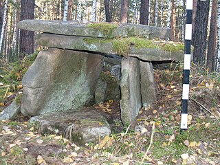
In recent years, many megaliths have been discovered in the Urals: dolmens, menhirs and a large megalithic cultic complex on Vera Island.

The history of human habitation in the Andean region of South America stretches from circa 15,000 BCE to the present day. Stretching for 7,000 km (4,300 mi) long, the region encompasses mountainous, tropical and desert environments. This colonisation and habitation of the region has been affected by its unique geography and climate, leading to the development of unique cultural and socn.

The Russian geoglyph refers to a geoglyph on slopes of the Zyuratkul Mountains in the Chelyabinsk region in Russia.

