Choquequirao

Last updated
Choquequirao
Choquequirao Plaza.JPG
Choquequirao citadel.
Peru physical map.svg
Archaeological site icon (red).svg
Shown within Peru
Location Santa Teresa, La Convención Province, Cusco Region, Perú
Region Andes
Coordinates 13°23′34″S72°52′26″W / 13.39278°S 72.87389°W / -13.39278; -72.87389 Coordinates: 13°23′34″S72°52′26″W / 13.39278°S 72.87389°W / -13.39278; -72.87389
TypeSettlement
Area18 km2 (6.9 sq mi)
History
Founded1536
Abandoned1572
Cultures Inca
Choquequirao main structures Choquequirao Incan Lost City.jpg
Choquequirao main structures
Truncated hilltop at Choquequirao Choquequirao-cimatruncada.jpg
Truncated hilltop at Choquequirao
Terraces at Choquequirao Terrazas de Choquequirao.jpg
Terraces at Choquequirao
White stone woman in the terraces of Choquequirao White stone woman.JPG
White stone woman in the terraces of Choquequirao
White stone llama in the terraces of Choquequirao White stone llama 2.JPG
White stone llama in the terraces of Choquequirao

Choquequirao (possibly from Quechua chuqi metal, k'iraw crib, cot) [1] [2] [3] [4] is an Incan site in southern Peru, similar in structure and architecture to Machu Picchu. The ruins are buildings and terraces at levels above and below Sunch'u Pata, the truncated hill top. The hilltop was anciently leveled and ringed with stones to create a 30 by 50 m platform.

Contents

Choquequirao at an elevation of 3,050 metres (10,010 ft) [5] is in the spurs of the Vilcabamba mountain range in the Santa Teresa district, La Convención Province of the Cusco Region. The complex is 1,800 hectares, of which 30–40% is excavated. [6] The site overlooks the Apurimac River canyon that has an elevation of 1,450 metres (4,760 ft).

The site is reached by a two-day hike from outside Cusco. [6] Choquequirao has topped in the prestigious Lonely Planet's Best in Travel 2017 Top Regions list. [7]

History

Choquequirao is a 15th- and 16th-century settlement associated with the Inca Empire, or more correctly Tahuantinsuyo. [8] The site had two major growth stages. This could be explained if Pachacuti founded Choquequirao and his son, Tupac Inca Yupanqui, remodeled and extended it after becoming the Sapa Inca. [9] Choquequirao is located in the area considered to be Pachacuti’s estate; which includes the areas around the rivers Amaybamba, Urubamba, Vilcabamba, Victos, and Apurímac.

Other sites in this area are Sayhuite, Machu Picchu, Chachabamba (Chachapampa), Choquesuysuy (Chuqisuyuy), and Guamanmarca (Wamanmarka); all of which share similar architectural styles with Choquequirao. [10] The architectural style of several important features appears to be of Chachapoya design, suggesting that Chachapoya workers were probably involved in the construction. This suggests that Tupaq Inka probably ordered the construction. Colonial documents also suggest that Tupac Inca ruled Choquequirao since his great grandson, Tupa Sayri, claimed ownership of the site and neighboring lands during Spanish colonization. [11]

It was one of the last bastions of resistance and refuge of the Son of the Sun (the "Inca"), Manco Inca Yupanqui, who fled Cusco after his siege of the city failed in 1535.

According to the Peruvian Tourism Office, "Choquequirao was probably one of the entrance check points to the Vilcabamba, and also an administrative hub serving political, social, and economic functions. Its urban design has followed the symbolic patterns of the imperial capital, with ritual places dedicated to Inti (the Incan sun god) and the ancestors, to the earth, water, and other divinities, with mansions for administrators and houses for artisans, warehouses, large dormitories or kallankas, and farming terraces belonging to the Inca or the local people. Spreading over 700 meters, the ceremonial area drops as much as 65 meters from the elevated areas to the main square." [5] The city also played an important role as a link between the Amazon Jungle and the city of Cusco.

Discovery

According to Ethan Todras-Whitehill of the New York Times, Choquequirao's first non-Incan visitor was the explorer Juan Arias Díaz in 1710. [12] The first written site reference in 1768 was made by Cosme Bueno  [ es ], but was ignored at the time.

The Prefect of the Province of Apurimac, J.J. Nuñez, encouraged Hiram Bingham to visit the 'Cradle of Gold', in order to discover any Incan treasure. Bingham was a delegate to the 1908 First Pan American Scientific Congress and was in Cusco at the time. Bingham decided to visit Choquequirao in 1909 to determine if it was Vilcapampa, the Capital of the last four Incas. He found three groups of buildings, mummified bodies, and places where dynamite had been used in the search of treasure. Visitors who had recorded their names included Count de Sartiges, Jose Maria Tejada and Marcelino Leon, 1834, Jose Benigno Samanez, Juan Manuel Rivas Plata and Mariana Cisneros, 1861, and three Almanzas, Pio Mogrovejo, and their treasure hunting workmen, 1885. However, Bingham decided it was merely a frontier fortress, and it tempted him to search further. [13]

Location and layout

Choquequirao is situated at an elevation of 3,000 m above sea level on a southwest-facing spur of a glaciated peak above the Apurimac River. [14] The region is characterized by mountain topography and covered with Amazonian flora and fauna. [15] It is 98 km west of Cusco, in the Vilcabamba range. The complex covers 6 km2. [16] Architecturally it is similar to Machu Picchu. The main structures, such as temples, huacas, elite residences, and fountain/bath systems are concentrated around two plazas along the crest of the ridge, which encompass approximately 2 km2 and follow Inca urban design. Also there is a conglomeration of common buildings clustered away from the plaza. Excavations and surface items suggest they were probably used for workshops and food preparation. [17] Most buildings are well-preserved and well-restored; restoration continues.

The terrain around the site was greatly modified. The central area of the site was leveled artificially and the surrounding hillsides were terraced to allow cultivation and small residential areas. [15] The typical Inca terraces form the largest constructions on site.

Many of the ceremonial structures are associated with water. There are two unusual temple wak'a sites that lie several hundred meters lower than the two plazas. These are carefully crafted step terraces down a steep slope are designed around water. [18] The site also contains a number of ceremonial structures such as the large usnu built on a truncated hill, the Giant Staircase, and an aqueduct providing water to the water shrines. [19]

Sectors

The archaeological complex of Choquequirao is divided into 12 sectors. While the contents of each sector are different, terraces used for various purposes are common throughout. It seems that most of the buildings here were either for ceremonial purposes, residences of the priests, or used to store food.

Ceremonial center

The ceremonial center of Choquequirao shares many features similar to those of other Inca ceremonial centers and pilgrimage sites, such as Isla del Sol, Quespiwanka (Qhispi Wank'a, palace of Huayna Capac), Machu Picchu/Llaqtapata, Tipon and Saywite. The long and treacherous route from Cusco to Choquequirao likely passed by Machu Picchu, leading onto the face of Machu Picchu Peak. From Llaqtapata, the path continued down into the Mollepata Valley, traversed the Yanamia pass at 4670 m, and continued across the Rio Blanco, finally reaching Choquequirao from above after an estimated 7- to 10-day journey. [25]

The ceremonial center consists of a main platform and a lower plaza. Stone lined channels carried ceremonial water, or chicha to shrines and baths throughout the site. The main platform, unique in its size and prominence, limited ceremonial activity to royalty and the ministerial class. This seems as such due to evidence showing that the only entrance to the platform was through a double-jam doorway, which functioned to control access to the sacred space. [25] Other features of the ceremonial center include structures that mark the direction of certain solar events, such as when the June and December solstice sun rises and sets.

Located in the main platform, the Giant Stairway opens to the sunrise of the December solstice. Measured at 25 meters long and 4.4 meters wide, this structure seems to have been purely ceremonial in function, since the stairs end abruptly partway down a hill, leading to nothing. Large boulders that rest upon the risers of the stairway become fully illuminated when the December solstice sun rises. Gary R. Ziegler and J. McKim Malville have postulated that when the boulders become illuminated, a wak'a is activated by its solar camaquen—a case similar to when the large stone of the Torreon at Machu Picchu becomes illuminated. [25]

In the lower plaza a group of structures were found that appeared to be water shrines and baths. This belief is held based on their strong resemblance to those at sector II of Llaqtapata and because there are numerous water channels leading to that portion of the plaza. [25] Overall, it seems as though the site was chosen, as Machu Picchu was, for its sacred geographical location, and was designed to facilitate ritual and ceremonial activity.

Subsectors

The area around Choquequiaro contains several subsectors that have been associated with the Inca culture that thrived in Choquequirao, suggesting that the subsectors are most likely part of the site. Design, construction style, and cultural parallels support that these sectors were tightly intertwined with Choquequiaro and the Inca at some point in their history. The lack of residential space in these sectors suggests that these were probably farming outposts from Choquequirao rather than an independent site. [26] Due to differences in design and construction styles, it is believed that these sectors were built in three different phases. [27] Like Choquequirao art style, the subsector also contains multiple camelid art and ceremonial phaqchas that are tightly related to Inca, especially Pachacuti’s government. [28]

Materials

All lithic materials utilized for the construction of the site and surrounding sectors were mined from the local quarries. [29] Due to the metamorphic rock in the quarries of Choquequirao, superb masonry like that at Machu Picchu could not be obtained. Instead, the entrances and corners were shaped from quartzite, and the walls were made of ashlar and plastered with clay and then painted in a light orange color. [30]

Art

Most of the rock art in Choquequirao is in the terraced area where cultivation occurred. Archaeologists have documented twenty-five semi-naturalistic figures on the terraces of sector VIII of Choquequirao. The rocks used to build the walls are dark schist while the camelid images are of white calcocuarcita, a sandstone of quartz and carbonate. [31] The camelid motifs vary between a maximum height of 1.94 m and one minimum of 1.25 m. [32] In 2004, archaeologist Zenobio Valencia from the University of San Antonio Abad of Cusco found several camelid figurines made of white stones in a group of terraces in one sector of the archaeological site. [8]

One recent discovery for example, uncovered a scene laid into the stone terraces with white quartzite depicting several llamas loaded with cargo standing by their handlers. Present on the uppermost terrace wall is a zigzag pattern of the same quartzite. This style of design is uniquely Chachapoya and not found in other sites of Inca construction, indicating that workers from Chachapoya may have been involved in the construction of Choquequirao. [33]

Access

Presently the only way to access Choquequirao is by a hard hike. The common trailhead begins at the village of San Pedro de Cachora, [34] which is approximately a 4-hour drive from Cuzco, along the Cusco-Abancay route. Another access point is from Huanipaca village, whose crossroad is located on the same route Cusco-Abancay, 4–5 km beyond the Cachora crossroad. Huanipaca offers a 15 km trail, half distance less than Cachora trail (31 km). Over 5,000 people trekked to Choquequirao in 2013. From Choquequirao it is possible to continue hiking to Machu Picchu. Most treks range from 7-day to 11-day hikes, and involve going over the Yanama Pass, which at 4,668 m is the highest point on the trek.

The construction of the cable car to Choquequirao has been declared a priority by the Apurímac Regional Government, which are destined to receive 220 million Peruvian Soles (US$82.7 million) to fund the project. It will reduce a two-day hike to a 15-minute cable car ride. [35] Carlos Canales, president of the National Chamber of Tourism (Canatur) believes that in the first year of operation the Choquequirao cable car will receive 200,000 tourists, which will generate an income of US$4 million, with the average visitor paying US$20 per ticket. [36]

See also

Notes

  1. Diccionario Quechua - Español - Quechua, Academía Mayor de la Lengua Quechua, Gobierno Regional Cusco, Cusco 2005 (Quechua-Spanish dictionary) (5-vowel-system)
  2. Ref Bertonio
  3. Teofilo Laime Ajacopa, Diccionario Bilingüe Iskay simipi yuyayk'ancha, La Paz, 2007 (Quechua-Spanish dictionary)
  4. Lee 1997
  5. 1 2 Choquequirao, Peru's Tourism Office, 2011
  6. 1 2 Trail to Choquequirao, El Comercio Newspaper, Lima, Peru, May 13, 2009, [Spanish] Archived April 16, 2013, at archive.today
  7. "Peru: Choquequirao tops Lonely Planet's 'Best in Travel 2017' list".
  8. 1 2 Echevarría López 2009, p.213.
  9. Echevarría López 2008, p.83.
  10. Echevarría López 2008, p.82.
  11. Ziegler 2011, pp.162-163.
  12. Ethan Todras-Whitehill in the New York Times
  13. Bingham, Hiram (1952). Lost City of the Incas . Weidenfeld & Nicolson. pp.  112–132. ISBN   9781842125854.
  14. Ziegler 2011, pp.162–163.
  15. 1 2 Echevarría López 2009, p.214.
  16. Ziegler 2011, p.162.
  17. Ziegler 2011, pp.163-164.
  18. Ziegler 2011, p. 164.
  19. Ziegler 2011, p. 162.
  20. Burga, Manuel.(2008). p. 103-104.
  21. 1 2 3 4 Burga, Manuel. (2008). p. 104.
  22. Burga, Manuel. (2008). p. 104-105.
  23. Burga, Manuel. (2008). p. 105.
  24. 1 2 3 Burga, Manuel. (2008). p. 106.
  25. 1 2 3 4 Ziegler 2011, p.167.
  26. Echevarría López 2008, pp.81-82
  27. Echevarría López 2008, p.77.
  28. Echevarría López 2008, pp.81-82.
  29. Echevarría López 2008, p.72
  30. Ziegler 2011, pp.164-165.
  31. Echevarría López 2009, pp.214-215.
  32. Echevarría López 2009, p.216.
  33. Ziegler 2011, p.165.
  34. Trekking To Machu Picchu, Horizon Guides, 2017
  35. Salazar, Carla. "Tramway planned for Machu Picchu's 'sister city'". AP Travel. Associated Press. Retrieved 31 August 2013.
  36. "Choquequirao recibiría 600 mil viajeros en el 2018 con teleférico". El Comercio. Retrieved 7 December 2012.

Related Research Articles

<span class="mw-page-title-main">Cusco</span> City in Peru

Cusco, often spelled Cuzco, is a city in Southeastern Peru near the Urubamba Valley of the Andes mountain range. It is the capital of the Cusco Region and of the Cusco Province. The city is the seventh most populous in Peru; in 2017, it had a population of 428,450. Its elevation is around 3,400 m (11,200 ft).

<span class="mw-page-title-main">Machu Picchu</span> 15th-century Inca citadel in Peru

Machu Picchu is a 15th-century Inca citadel located in the Eastern Cordillera of southern Peru on a 2,430-meter (7,970 ft) mountain ridge. Often referred to as the "Lost City of the Incas", it is the most familiar icon of the Inca Empire. It is located in the Machupicchu District within Urubamba Province above the Sacred Valley, which is 80 kilometers (50 mi) northwest of Cusco. The Urubamba River flows past it, cutting through the Cordillera and creating a canyon with a tropical mountain climate.

<span class="mw-page-title-main">Pachacuti</span> Sapa Inca of the Inca Empire

Pachacuti Inca Yupanqui was the ninth Sapa Inca (1418–1471/1472) of the Kingdom of Cusco which he transformed into the Inca Empire. Most archaeologists now believe that the famous Inca site of Machu Picchu was built as an estate for Pachacuti.

<span class="mw-page-title-main">Vilcabamba, Peru</span> Capital of the Neo-Inca State

Vilcabamba, Willkapampa is often called the Lost City of the Incas. Vilcabamba means "sacred plain" in Quechua. The modern name for the Inca ruins of Vilcabamba is Espiritu Pampa. Vilcabamba is located in Echarate District of La Convención Province in the Cuzco Region of Peru.

<span class="mw-page-title-main">Chachapoya culture</span> Andean culture

The Chachapoyas, also called the "Warriors of the Clouds", was a culture of the Andes living in the cloud forests of the southern part of the Department of Amazonas of present-day Peru. The Inca Empire conquered their civilization shortly before the Spanish conquest in the 16th century. At the time of the arrival of the conquistadors, the Chachapoyas were one of the many nations ruled by the Incas, although their incorporation had been difficult due to their constant resistance to Inca troops.

<span class="mw-page-title-main">Ollantaytambo</span> Archaeological site in Peru

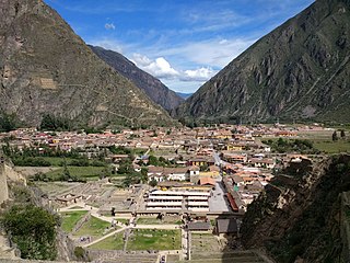
Ollantaytambo is a town and an Inca archaeological site in southern Peru some 72 km (45 mi) by road northwest of the city of Cusco. It is located at an altitude of 2,792 m (9,160 ft) above sea level in the district of Ollantaytambo, province of Urubamba, Cusco region. During the Inca Empire, Ollantaytambo was the royal estate of Emperor Pachacuti, who conquered the region, and built the town and a ceremonial center. At the time of the Spanish conquest of Peru, it served as a stronghold for Manco Inca Yupanqui, leader of the Inca resistance. Located in the Sacred Valley of the Incas, it is now an important tourist attraction on account of its Inca ruins and its location en route to one of the most common starting points for the four-day, three-night hike known as the Inca Trail.

<span class="mw-page-title-main">Sacred Valley</span> Valley in the Andes Mountains of Peru

The Sacred Valley of the Incas, or the Urubamba Valley, is a valley in the Andes of Peru, north of the Inca capital of Cusco. It is located in the present-day Peruvian region of Cusco. In colonial documents it was referred to as the "Valley of Yucay." The Sacred Valley was incorporated slowly into the incipient Inca Empire during the period from 1000 to 1400 CE.

<span class="mw-page-title-main">Vitcos</span> Archaeological site in Peru

Vitcos was a residence of Inca nobles and a ceremonial center of the Neo-Inca State (1537-1572). The archaeological site of ancient Vitcos, called Rosaspata, is in the Vilcabamba District of La Convención Province, Cusco Region in Peru. The ruins are on a ridge overlooking the junction of two small rivers and the village of Pucyura. The Incas had occupied Vilcabamba, the region in which Vitcos is located, about 1450 CE, establishing major centers at Machu Picchu, Choquequirao, Vitcos, and Vilcabamba. Vitcos was often the residence of the rulers of the Neo-Inca state until the Spanish conquest of this last stronghold of the Incas in 1572.

<span class="mw-page-title-main">Llaqtapata</span> Archaeological site in Peru

Llaqtapata (Quechua) llaqta place, pata elevated place / above, at the top / edge, bank, shore, pronounced 'yakta-pahta', Hispanicized Llactapata) is an archaeological site about 5 km (3.1 mi) east of Machu Picchu. The complex is located in the Cusco Region, La Convención Province, Santa Teresa District, high on a ridge between the Ahobamba and Santa Teresa drainages.

<span class="mw-page-title-main">Inca Bridge</span> Bridge providing access to Machu Picchu in Peru

The Inca Bridge or Inka Bridge refers to one of two places related to access to Machu Picchu, in Peru.

<span class="mw-page-title-main">Architecture of Peru</span>

Peruvian architecture is the architecture carried out during any time in what is now Peru, and by Peruvian architects worldwide. Its diversity and long history spans from ancient Peru, the Inca Empire, Colonial Peru to the present day.

<span class="mw-page-title-main">Salcantay</span> Mountain in Peru

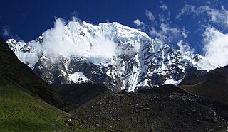
Salcantay, Salkantay or Sallqantay is the highest peak in the Vilcabamba mountain range, part of the Peruvian Andes. It is located in the Cusco Region, about 60 km (40 mi) west-northwest of the city of Cusco. It is the 38th-highest peak in the Andes and the twelfth-highest in Peru. However, as a range highpoint in deeply incised terrain, it is the second most topographically prominent peak in the country, after Huascarán.

A previously unknown Inca settlement, Quriwayrachina or Quri Wayrachina, was found in the Willkapampa mountain range in the Cusco Region of Peru in 2001. The site lies in the Santa Teresa District of the La Convención Province, north of the archaeological site of Choquequirao and west of the mountains Kiswar and Quriwayrachina (Corihuayrachina), on a mountain named Victoria. Close to nearby ancient Inca mines, the surrounding hills are covered with the littered stones from more than 200 structures in this Inca outpost.

<span class="mw-page-title-main">Inti Punku</span> Archaeological site in Peru

Inti Punku or Intipunku is an archaeological site in the Cusco Region of Peru that was once a fortress of the sacred city, Machu Picchu. It is now also the name of the final section of the Incan Trail between the Sun Gate complex and the city of Machu Picchu. It was believed that the steps were a control gate for those who enter and exited the Sanctuary.

<span class="mw-page-title-main">Cusichaca River</span> River in Peru

Cusichaca River, is a river in Peru located in the Cusco Region, Urubamba Province, on the border of the districts Machupicchu and Ollantaytambo. Its waters flow to the Vilcanota River.

<span class="mw-page-title-main">Tipón</span> Archaeological park in Peru near Cusco with an Incan monumental hydraulic system

Tipón, is a sprawling early fifteenth-century Inca archaeological park that is situated between 3,250 metres (10,660 ft) and 3,960 metres (12,990 ft) above sea level, located 22 kilometres (14 mi) southeast of Cusco near the village of Tipón. It consists of several ruins enclosed by a powerful defensive wall about 6 kilometres (3.7 mi) long. The most renown part of the park is the group of precise and right angled monumental terraces irrigated by a network of water canals fed by a monumental fountain channeling water from a natural spring. The site includes ancient residential areas and a remarkable amount of petroglyphs in its upper part.

<span class="mw-page-title-main">Patallacta</span> Archaeological site in Peru

Patallacta, Llactapata or Q'ente Marka is an archaeological site in Peru located in the Cusco Region, Urubamba Province, Machupicchu District. It is situated southeast of the site Machu Picchu, at the confluence of the rivers Cusichaca and Vilcanota on a mountain named Patallacta.

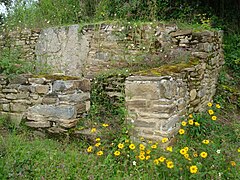
Purunllacta or Purum Llacta (Quechua purum, purun savage, wild / wasteland, llaqta place is an archaeological site of the Chachapoya culture in Peru. It is situated in the Amazonas Region, Chachapoyas Province, Cheto District, on the mountain of the same name. It lies northeast and near the archaeological site of Purunllacta of the Soloco District.

<span class="mw-page-title-main">Incahuasi (Apurímac)</span> Mountain in Peru

Incahuasi is a mountain in the Vilcabamba mountain range in the Andes of Peru whose summit reaches 4,315 metres (14,157 ft) above sea level. It is situated in the Apurímac Region, Abancay Province, Cachora District. The mountain lies on the bank of the Apurímac River, opposite the archaeological site of Choquequirao. On its northern slope there is a small archaeological site named Inka Raqay. Tourists are also attracted by the viewpoint of Incahuasi which provides good views of the Apurímac valley, Choquequirao and Padreyoc.

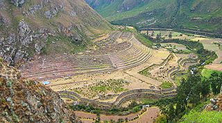
The Inca complex at Pisac is a large Incan complex of agricultural terraces, residences, guard posts, watchtowers and a ceremonial/religious centre located along a mountain ridge above the modern town of Pisac in the Sacred Valley of Peru. In 1983 the Pisac National Archeological Park was established to recognize the importance of and to protect the remains of the complex.

References