Piura

Last updated

Piura
San Miguel de Piura
PLAZA DE ARMAS DE PIURA - PIURA.jpg
Piura desde el aire.jpg
Edificio Gobierno.jpg
Estadio-miguel-grau-piura-entrada-occidente.jpg
Ovalo Miguel Grau piura.jpg
Edificis del jiron Tacna de Piura.jpg
MINISTRO NIETO VIAJO A PIURA PARA SUPERVISAR LA RESPUESTA DEL SECTOR DEFENSA Y LAS FFAA ANTE LA EMERGENCIA (33008722853).jpg
Top:Saint Michael the Archangel Cathedral, Second:Piura University, Piura Miguel Grau Stadium, Third:Piura Almas Square, A street for Hotel Tacna, Bottom:Piura River and Barrio Norte area's panoramic view (all item of left to right)
Bandera de Piura.svg
Escudo ciudad de Piura.svg
Nickname(s): 
La Primera Ciudad
(The First City)
La Ciudad del Eterno Calor
(The City of The Eternal Heat)
Peru location map.svg
Red pog.svg
Piura
Location in Peru
Coordinates: 5°12′S80°38′W / 5.200°S 80.633°W / -5.200; -80.633
Country Peru
Region Piura
Province Piura
Founded1532
Founded by Francisco Pizarro
Government
  AlcaldeGabriel Madrid
(2023-2026)
Area
  Total621.2 km2 (239.8 sq mi)
Elevation
55 m (180 ft)
Population
 (2020)
  Total630,244
  Estimate 
(2020) [1]
630,000
  Rank7th
  Density647/km2 (1,675/sq mi)
Demonym Piurano
Time zone UTC/GMT-5
Area code 73
Website munipiura.gob.pe

Piura is a city in northwestern Peru located north of the Sechura Desert on the Piura River. It is the capital of the Piura Region [2] and the Piura Province. Its population was 484,475 as of 2017 and is the 7th most populous city in Peru. The city is located in the central eastern part of the Piura Region, 981 kilometers from the countrys capital, Lima and is near to the border with Ecuador.

Contents

It was here that Spanish Conqueror Francisco Pizarro founded the third Spanish city in South America and first in Peru, under the name of San Miguel de Piura, in July [3] :27 or August [4] of 1532. Piura declared its independence from Spain on 4 January 1821, a few months before Peru gained its independence on 28 July, 1821. [5] It is the commercial and administrative center of the Department of Piura.

History

Plaza de Armas of Piura Piura Plaza de Armas.jpg
Plaza de Armas of Piura

Pre-columbian era

Like most of northern Peru, the territory of Piura has been inhabited by their autochthonous group of natives called tallanes and yungas. These groups lived without an organization or single leader to rule until the Muchik culture eventually took control, and the mixture of these evolved into the Vicús culture. The Chimor, Moche and Wari Empire used to occupy the area surrounding the city. Centuries later, Piura came under the rule of Tupac Inca Yupanqui of the Inca Empire for at least 40 years before the Spanish arrived.

Colonial era

Francisco Pizarro came to the area and established it as the third Spanish city in South America, and Spain's first city in Peru. [6] He originally went all the way to what is now Tumbes but decided it was not a suitable base for his operations. With the arrival of the Spanish in 1532, the current mestizo and creole cultures of Piura were born. This mestizo culture includes influences from Spanish Extremadura and Andalucia; African influence, owing to the arrival of slaves from Madagascar (Malgache slaves); Chinese coolies who migrated from Canton to work the rice fields and replace the slaves; and also Roma Gypsies who came as pirates looking for pearls, or incognito as Spanish horsemen.

The Spanish named the city from the Quechuan word pirhua, meaning "abundance". Nowadays, Piura is known as the "Ciudad del eterno calor" meaning "The city of eternal heat" because it is hot all year round.

Independence

In 1820, with the incursions of Admirals Guillermo Brown and Cochrane of the liberating expedition of José de San Martín, the Piuran population enthusiastically joined the liberating cause, and on January 4, 1821, the independence of Piura was proclaimed in the atrium of the temple of San Francisco. The proclamation was an feat led by the heroes José de Lama, Tomás Cortés, Baltazar Taboada, Tomás Diéguez, the Seminario brothers and others. Likewise, the Piura division of 1,000 men contributed victoriously to the independence of Quito, taking part in the Battle of Pichincha, on May 24, 1822.

Republican era

In 1861, the Department of Piura was created and Piura became the departments capital. The department consisted other three provinces at the time, Piura, Paita and Ayabaca.

In the 1860s, the city of Piura became more dynamic with the cultivation of Pima cotton, brought by Don Emilio Hilbck from the state of Arizona in the United States, which promoted the industrialization and development of the city and the region, and strong immigration. of English, German and Spanish, in that order, and to a lesser extent Italians and Chinese, who brought their customs and also their knowledge of commerce and industry. Many Americans also arrived. They quickly incorporated themselves into the social fabric, forming families with local ladies and inevitably creating new tastes and habits. Even Piura's cuisine was enriched. In agriculture, the use of the steam pump and specialized machinery was introduced, allowing more cropland to be irrigated, expanding the network of canals since the success of Piuran cotton in the international market was a great stimulus for agriculture. New industries appeared such as deep-sea fishing by whaling fleets, mass production and export trade of toquilla straw hats from Catacaos and annexes.

Miguel Grau of Piura Miguel Grau1.jpg
Miguel Grau of Piura

Peruvian war hero of the War of the Pacific against Chile, Miguel Grau Seminario was born in Piura on July 27 1834. He became a hero during the naval Battle of Angamos. According to historians and the Peruvian state, since 2011, they have given the official birthplace of Grau not to Piura but to the port of Paita. Miguel Grau is the most renowned and iconic Peruvian naval officer, being known as el Caballero de los Mares (Spanish for "Gentleman of the Seas").

In the 1980s, Piura and the department again experienced an ascending and thriving commercial, industrial and socioeconomic development, despite having been devastated in the 1983 disaster, as a consequence of the El Niño phenomenon, manifested in torrential rains for six months. that affected its industry, commerce and its urban infrastructure. The El Niño phenomenon that occurred from late 1997 to mid-1998 found the city better prepared, although two of its bridges fell and were subsequently replaced. When it seemed that it was going to be a dry season, in February 2017 it began to rain heavily in what later became known as the coastal Niño phenomenon, and in the early hours of March 27, the river overflowed over the center and northern areas. of the city, causing unforeseen damage, affecting health networks and communication routes.

Present

Piura is experiencing strong development of its commercial sector with the installation of large shopping centers and department stores in no less than five points of the city considered strategic by investors. Furthermore, in recent years the city has expanded considerably with the creation of new developments and human settlements. Likewise, its industrial sector was also developed with the inauguration of the "Piura Futura" industrial estate, northwest of Piura. [7]

Geography

Climate

Piura Department has a desert and semi-desert climate on the coast and the western slopes of the Andes, whereas on the eastern slopes the climate is subtropical. Precipitation is sparse except during El Niño events, when rainfall is abundant and water flows through normally dry watercourses, causing flooding and large-scale land movements.

Climate data for Piura (FAP Captain Guillermo Concha Iberico International Airport) 1961–1990, extremes 1932–present
MonthJanFebMarAprMayJunJulAugSepOctNovDecYear
Record high °C (°F)37.9
(100.2)
38.4
(101.1)
38.2
(100.8)
39.9
(103.8)
36.1
(97.0)
35.0
(95.0)
33.2
(91.8)
33.0
(91.4)
34.1
(93.4)
34.0
(93.2)
37.0
(98.6)
36.6
(97.9)
39.9
(103.8)
Mean daily maximum °C (°F)33.4
(92.1)
34.2
(93.6)
34.3
(93.7)
33.2
(91.8)
30.8
(87.4)
28.9
(84.0)
27.9
(82.2)
28.3
(82.9)
29.0
(84.2)
29.6
(85.3)
30.4
(86.7)
32.0
(89.6)
31.0
(87.8)
Daily mean °C (°F)26.8
(80.2)
27.8
(82.0)
27.8
(82.0)
26.6
(79.9)
24.5
(76.1)
22.9
(73.2)
21.8
(71.2)
21.9
(71.4)
22.3
(72.1)
22.9
(73.2)
23.6
(74.5)
25.2
(77.4)
24.5
(76.1)
Mean daily minimum °C (°F)20.3
(68.5)
21.4
(70.5)
21.3
(70.3)
19.9
(67.8)
18.3
(64.9)
16.8
(62.2)
15.8
(60.4)
15.6
(60.1)
15.6
(60.1)
16.2
(61.2)
16.9
(62.4)
18.4
(65.1)
18.0
(64.4)
Record low °C (°F)10.0
(50.0)
14.3
(57.7)
16.0
(60.8)
12.2
(54.0)
10.0
(50.0)
10.0
(50.0)
10.0
(50.0)
10.0
(50.0)
10.5
(50.9)
8.4
(47.1)
11.1
(52.0)
9.8
(49.6)
8.4
(47.1)
Average precipitation mm (inches)16.9
(0.67)
19.0
(0.75)
32.4
(1.28)
24.4
(0.96)
15.1
(0.59)
5.0
(0.20)
0.5
(0.02)
0.0
(0.0)
0.0
(0.0)
1.1
(0.04)
0.8
(0.03)
1.2
(0.05)
116.4
(4.58)
Average precipitation days (≥ 1.0 mm)1.82.33.72.60.40.50.00.00.10.20.40.712.8
Average relative humidity (%)51555155596666656460585659
Source 1: NOAA, [8] Meteo Climat (record highs and lows) [9]
Source 2: Deutscher Wetterdienst (mean temperatures 1961–1990, precipitation days 1970–2003 and humidity 1955–1969) [10]

Hydrography

Puente Bolognesi crossing the Piura river PUENTE BOLOGNESI - PIURA.jpg
Puente Bolognesi crossing the Piura river

The hydrography of Piura Department is determined mainly by the amount of rainfall originating in the Pacific Ocean. This rainfall is itself determined by the meeting of two ocean currents on the southern

coast of the department, around the bay of Sechura: the cold Humboldt current at 13-19 °C, and the warm El Niño at 21-27 °C. These conditions lead to fluctuations in offshore sea temperatures, which are 18-23 °C in winter and spring, and 23-27 °C in summer and sometimes in autumn.

The mean annual humidity is 66%. The mean atmospheric pressure is 1008.5 hPa, while winds are mainly from the north at an average speed of 3 m/s. Annual rainfall varies between 10 and 200 mm at altitudes of 100–500 m; between 200 and 800 mm at altitudes of 500–1500 m; and averages 1,550 mm at altitudes above 1500 m.

Most of the region is arid, with rainfall concentrated in the high Andean areas, while on the wide plains the main water sources are seasonal rivers flowing from the north: the Chira and the Piura. The southern half of the plain consists of the Sechura Desert, which supports herbaceous vegetation.

The main rivers are the Piura, the Huancabamba and the Chira. The reservoir of Poechos has been created within the course of the Chira. It has a capacity of 1,000,000,000 cubic metres and irrigates large portions of the coastal region. The river Quiroz, a tributary of the Piura, supplies the huge artificial lake of San Lorenzo. On the Huancabamba, in the mountains, there is a hydroelectric power station supplying energy to the region.

Demographics

Piura is the 7th most populous city in Peru, after Lima, Arequipa, Trujillo, Chiclayo, Huancayo and Iquitos. The city has an estimated population of 630,244 according to the census carried out by the Instituto Nacional de Estadística e Informática in 2020. [11]

The Metropolitan area of ​​Piura is made up of the urban centers of the districts of Piura, Veintisirse de Octubre, Castilla and Catacaos, with the city of Piura being the main urban nucleus, in accordance with the "Urban Development Plan of the districts of Piura, Twenty-sixth of October, Castilla and Catacaos in 2032".

Education

University of Piura Edificio Ingenieria.jpg
University of Piura

Universities

The city of Piura has a considerable offer in terms of university vocational training centers; The following universities and a recognized Professional Technical School for business training operate there:

Branches of:

Tourism

Piura is one of the top tourist destinations in Peru. One of the best-known tourist attractions in Piura is La Esmeralda beach, known as Colan beach for it is located near the town of Colan. It is a very long beach with warm waters. Local people like to go there during holidays.

There are also great spots for surfers, like Playa Cangrejos, Mancora Beach and Cabo Blanco. Cabo Blanco was made famous by visitor Ernest Hemingway in 1956, where he supervised the filming of The Old Man and the Sea . [12]

Culture and folklore

Cuisine

Piura is host to a stunning mestizo culture (one of the oldest in South America, for Piura is the third Spanish city founded on that continent) most famous for gastronomical dishes like Seco de chabelo, algarrobina-based drinks, many types of seafood and fish, like ceviche and Natilla Sweets. Popular crafts include Chulucana pottery, and Catacaos is famous for its hats and its silversmithing. The small town of Simbila, is very popular for its handcrafts and pottery.

Music and dance

The tondero and cumanana are the traditional music of mestizo Piura and northern parts of Lambayeque. There are also several famous Peruvian Waltz that came from these regions (northern Peruvians have their own style).

Estadio Miguel Grau Estadio-miguel-grau-(piura)-desde-tribuna-oriente-2018.jpg
Estadio Miguel Grau

Sport

The most popular sport in Piura is Association football (soccer). The cities largest football club is Atlético Grau, which participates in the Peruvian Primera División. Another popular club is Atlético Torino. Piura were one of the host cities for the 2005 FIFA U-17 World Championship, where its stadium, Estadio Miguel Grau, hosted. The stadium is named after the Peruvian war hero, Miguel Grau Seminario and has a capacity of 25,000.

Cathedral of Piura CATEDRAL DE PIURA - PIURA.jpg
Cathedral of Piura

Churches

Transportation

Road

The Pan-American Highway goes right through Piura and connects it to other cities in Peru and South America. Mototaxi's are a common form of transportation in the city, offering taxi or business's services. Buses are also common in the city.

Air

Piura is served by the Cap. FAP Guillermo Concha Iberico International Airport, which only has one direct destination to Lima's Jorge Chávez International Airport.

Rail

A project known as the Tren de la Costa is planned.[ citation needed ] The project aims to serve all cities along the Peruvian coast from Ica to Sullana. The railway would go through Piura.

Notable people

Sister cities

Related Research Articles

<span class="mw-page-title-main">Geography of Peru</span>

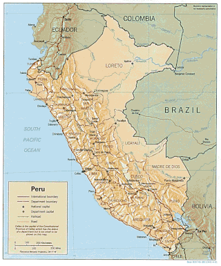
Peru is a country on the central western coast of South America facing the Pacific Ocean. It lies wholly in the Southern Hemisphere, its northernmost extreme reaching to 1.8 minutes of latitude or about 3.3 kilometres (2.1 mi) south of the equator. Peru shares land borders with Ecuador, Colombia, Brazil, Bolivia, and Chile, with its longest land border shared with Brazil.

<span class="mw-page-title-main">Demographics of Peru</span> Demographics of country

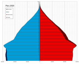
This is a demography of the population of Peru including population density, ethnicity, education level, the health of the populace, economic status, religious affiliations and other aspects of the population.

<span class="mw-page-title-main">Department of La Libertad</span> Department in 12 provinces and 83 districts, Peru

La Libertad is a department and region in northwestern Peru. Formerly it was known as the Department of La Libertad. It is bordered by the Lambayeque, Cajamarca and Amazonas regions on the north, the San Martín Region on the east, the Ancash and Huánuco regions on the south and the Pacific Ocean on the west. Its capital is Trujillo, which is the nation's third biggest city. The region's main port is Salaverry, one of Peru's largest ports. The name of the region is Spanish for "freedom" or "liberty"; it was named in honor of the Intendancy of Trujillo's proclaiming independence from Spain in 1820 and fighting for that. It is the ninth smallest department in Peru, but it is also its second-most populous department after Piura and its second-most densely populated department after Lambayeque.

<span class="mw-page-title-main">Department of Piura</span> Departments of Peru

Piura is a coastal department and region in northwestern Peru. The region's capital is Piura and its largest port cities, Paita and Talara, are also among the most important in Peru. The area is known for its tropical and dry beaches. It is the most populous department in Peru, its twelfth smallest department, and its fourth-most densely populated department, after Tumbes, La Libertad, and Lambayeque.

<span class="mw-page-title-main">Sechura Desert</span> Desert along the coast of Peru

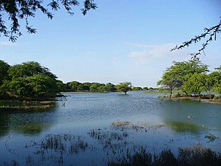
The Sechura Desert is a coastal desert located south of the Piura Region of Peru along the Pacific Ocean coast and inland to the foothills of the Andes Mountains. Its extreme aridity is caused by the upwelling of cold coastal waters and subtropical atmospheric subsidence, but it is also subject to occasional flooding during El Niño years. In 1728, the town of Sechura was destroyed by a tsunami and was later rebuilt in its present location. In 1998, runoff from flooding rivers caused the formation of a temporary lake some 145 km (90 mi) long filling the Bayóvar Depression. Short rivers flowing across the desert from the Andes support intensive irrigation-based agriculture.

<span class="mw-page-title-main">Miguel Grau Seminario</span> Peruvian naval officer

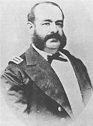
Miguel María Grau Seminario was the most renowned Peruvian naval officer and hero of the naval battle of Angamos during the War of the Pacific (1879–1884). He was known as el Caballero de los Mares for his kind and chivalrous treatment of defeated enemies and is esteemed by both Peruvians and Chileans. He is an iconic figure for the Peruvian Navy, and one of the most famous merchant marine and naval military leaders of the Americas.

<span class="mw-page-title-main">Paita</span> City in Piura, Peru

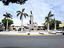
Paita is a city in northwestern Peru. It is the capital of the Paita Province which is in the Piura Region. It is a leading seaport in the region. Paita is located 1,089 km northwest of the country's capital Lima, and 57 km northwest of the regional capital of Piura. Starting in 2014, the city has considered ideas for separating from the Piura Region, proclaiming itself as the "Miguel Grau Region".

<span class="mw-page-title-main">Ayabaca Province</span> Province in Piura, Peru

Ayabaca or Ayavaca is one of the eight provinces of the Piura Region, in northwestern Peru. It borders Ecuador on the north and northeast, Huancabamba Province and Morropón Province on the south, and the Piura and Sullana provinces on the west. This province is located in the western Andes and its capital is the town of Ayabaca, which is the highest in the whole region.

<span class="mw-page-title-main">Sullana</span> Place in Piura, Peru

Sullana is the capital of the Sullana Province, in the north-western coastal plains of Peru on the Chira valley.

<span class="mw-page-title-main">Piura Province</span> Province in Piura, Peru

Piura is a province in the Piura Region in northwestern Peru. Its capital, the city of Piura, is also the regional capital. The province is the most populous in the region as well as its center of economic activity.

<span class="mw-page-title-main">Tondero</span>

Tondero is a dance and guitar rhythm from Peru that developed in the country's northern coastal region (Piura–Lambayeque).

<span class="mw-page-title-main">Sechura Province</span> Province in Piura, Peru

The Sechura Province is the largest of eight provinces of the Piura Region in Peru.

<span class="mw-page-title-main">Spanish immigration to Peru</span>

A Spanish Peruvian is a Peruvian citizen of Spanish descent. Among European Peruvians, the Spanish are the largest group of immigrants to settle in the country.

<span class="mw-page-title-main">Catacaoan languages</span> Extinct Peruvian language family

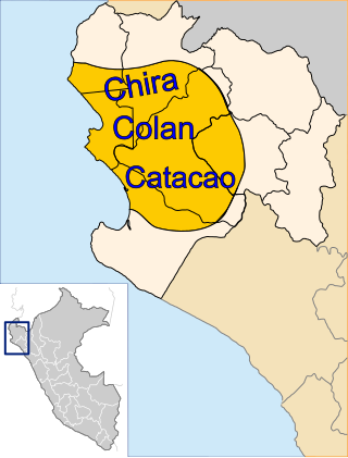
The Catacaoan languages are an extinct family of three languages spoken in the Piura Region of Peru. The three languages in the family are:

<span class="mw-page-title-main">Atlético Grau</span> Football club

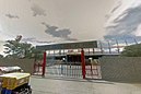
Club Atlético Grau, more commonly known as Atlético Grau or simply, Grau, is a Peruvian professional football club based in the city of Piura. The club was founded in 1919 and plays in the Peruvian Primera División, the top tier of Peruvian football. It is one of the most popular clubs in northern Peru and the Piura region along with Alianza Atlético. The clubs home ground is Estadio Miguel Grau Piura which has a capacity of 25,500. However, the club currently plays at Estadio Municipal de Bernal as Estadio Miguel Grau is being renovated.

<span class="mw-page-title-main">2016–17 South American floods</span> Natural disasters in South America

From December 2016 and continuing until May 2017, much of western and central South America was plagued by persistent heavy rain events. In Peru, one of the most severely impacted nations, it has been referred to as the 2017 Coastal Niño. The flooding was preceded by drought-like conditions throughout the region for much of 2016 and a strong warming of sea temperatures off the coast of Peru.

<span class="mw-page-title-main">Piura River</span> River in Peru

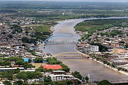
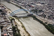
The Piura River is a river in northern Peru. The river flows westward from the Andes to the Pacific Ocean and is susceptible to major flooding. Piura is the largest city along the river's course.

References

  1. Perú: Población estimada al 30 de junio y tasa de crecimiento de las ciudades capitales, por departamento, 2011 y 2015. Perú: Estimaciones y proyecciones de población total por sexo de las principales ciudades, 2012-2015 (Report). Instituto Nacional de Estadística e Informática. March 2012. Retrieved 3 June 2015.
  2. "Departamento de Piura", travelsradiate.com, accessed 25 March 2011.
  3. Hemming, J., 1970, The Conquest of the Incas, New York: Harcourt Brace Jovanovich, Inc., ISBN   0151225605
  4. "Historia de Piura".
  5. Box, Ben (2004). The South American Handbook (80 ed.). Footprint Travel Guides. p. 1132. ISBN   978-1-903471-70-8.
  6. Andagoya, Pascual de. Narrative of the Proceedings of Pedrarias Davila. The Hakluyt Society. Retrieved 21 June 2019 via Wikisource.
  7. "Se inauguró en Piura el nuevo parque industrial de la región norte". NAI PERU (in Spanish). Retrieved 16 April 2024.
  8. "Piura Climate Normals 1961–1990". National Oceanic and Atmospheric Administration . Retrieved 4 July 2017.
  9. "Station Capitan Fap" (in French). Météo Climat. Retrieved 4 July 2017.
  10. "Klimatafel von Piura, Prov. Piura / Peru" (PDF). Baseline climate means (1961-1990) from stations all over the world (in German). Deutscher Wetterdienst. Retrieved 4 July 2017.
  11. "Directorio Nacional de Centros Poblados".
  12. "Cabo Blanco ist Hemingways Herbst – Hemingways Welt". 8 December 2013. Retrieved 21 June 2019.
  13. "Our Cities". sistercitiesokc.org. Sister Cities OKC, Inc. Retrieved 19 December 2021.
  14. "Ayuntamiento". trujillociudad.com (in Spanish). Trujillo Ciudad. Retrieved 19 December 2021.