Place du Canada

Last updated
Place du Canada
Windsor, Macdonald, St. George.JPG
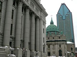
Place du Canada from René Lévesque Boulevard.
Montreal-blank.png
Red pog.svg
Type Town square
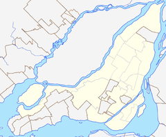
Location Downtown Montreal, Ville-Marie Montreal, Quebec, Canada
Coordinates 45°29′54″N73°34′08″W / 45.498375°N 73.568917°W / 45.498375; -73.568917 Coordinates: 45°29′54″N73°34′08″W / 45.498375°N 73.568917°W / 45.498375; -73.568917
Area1.4 hectares (3.46 acres)
Created1876 (1876) (renamed 1967)
Operated byCity of Montreal
StatusOpen all year

Place du Canada (part of Dominion Square until 1967) is a large urban square in downtown Montreal.

Downtown Montreal Neighbourhood of Montreal in Quebec, Canada

Downtown Montreal is the central business district of Montreal, Quebec, Canada.

Contents

Overview

At 14,000 square metres (150,000 sq ft) it is slightly larger than the adjacent Dorchester Square, with a more varied topography due to a downward slope towards De la Gauchetière Street. Place du Canada also differs from Dorchester Square in having manicured, though densely packed, pockets of flora arranged to impede direct lines of sight and diffuse pedestrian traffic. The French term place can roughly be translated as denoting a plaza, which has a different legal definition from squares or parks in Montreal. It is open twenty-four hours per day and is bordered by René Lévesque Boulevard to the North, Peel to the East, De la Cathédrale to the West and De la Gauchetière Street to the South.

Dorchester Square square in downtown Montreal, Quebec, Canada

Dorchester Square (officially in French: square Dorchester is a large urban square in downtown Montreal. Together with Place du Canada, the area is just over 21,000 m2 or 2.1 ha of manicured and protected urban parkland bordered by René Lévesque Boulevard to the south, Peel Street to the west, Metcalfe Street to the east and Dorchester Square Street to the north. The square is open to the public 24 hours a day and forms a focal point for pedestrian traffic in the city. Until the creation of Place du Canada in 1967, the name "Dominion Square" had been applied to the entire area.

De la Gauchetière Street street in Montreal; pedestrian zone in Chinatown district

De la Gauchetiere Street is a street in Montreal, Quebec, Canada, running through downtown Montreal, the International District and Chinatown.

Plaza public square in the center of a town or city

A plaza, pedestrian plaza, or place is an open urban public space, such as a city square.

Photo of Dominion Square in 1927 and the 1907 Groundplan. Notice the key design differences between the square and the plaza Square Dominion 1907.jpg
Photo of Dominion Square in 1927 and the 1907 Groundplan. Notice the key design differences between the square and the plaza

History

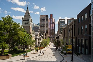
St. George's Anglican Church from Place du Canada St. George's Anglican Church.jpg
St. George's Anglican Church from Place du Canada
Centre of the plaza with cenotaph in foreground and 1000 de La Gauchetiere, Place-du-Canada and the Chateau Champlain in the background. Path to Place du Canada.JPG
Centre of the plaza with cenotaph in foreground and 1000 de La Gauchetière, Place-du-Canada and the Chateau Champlain in the background.

Place du Canada was developed along with the present Dorchester Square between 1872 and 1876 and was formally inaugurated that year as Dominion Square. It quickly developed into a prestige address and major transportation hub, with streetcars, cabs, carriages (and by 1889) the Canadian Pacific Railway's Windsor Station at the southwest corner of the plaza. What had once been an informal meeting place and common green would be formalized as a pedestrian traffic corridor, linking the estates and middle class suburbs to the west and northwest with the commercial sector moving up the hill from the southeast. As an urban square, it satisfied two goals; first to provide a method of diffusing transit nodes, and second as an open manicured natural environment to provide rest, recreation and a healthy respite from the cramped industrial and business core immediately south of the area.

Canadian Pacific Railway railway in Canada

The Canadian Pacific Railway (CPR), also known formerly as CP Rail between 1968 and 1996, and known as simply Canadian Pacific is a historic Canadian Class I railroad incorporated in 1881. The railroad is owned by Canadian Pacific Railway Limited, which began operations as legal owner in a corporate restructuring in 2001.

Windsor Station (Montreal) railway station in Ville-Marie, Canada

Windsor Station is a former railway station in Montreal, Quebec, Canada. It used to be the city's Canadian Pacific Railway (CPR) station, and served as the headquarters of CPR from 1889 to 1996. It is bordered by Avenue des Canadiens-de-Montréal to the north, Peel Street to the east, Saint Antoine Street to the south and the Bell Centre to the west.

After the cholera outbreak of 1851, the area had been the site for several hastily convened cemeteries of various denominations. Beginning in 1854, the City of Montreal began exhuming the bodies from the Saint-Antoine Catholic Cemetery to be relocated to Notre-Dame-des-Neiges Cemetery on the northeast slope of Mount Royal. This allowed for the extension of Dorchester Boulevard (now René-Lévesque Boulevard) to the west and the development of this area. Several large properties were surveyed and offered for sale.

Cholera Bacterial infection of the small intestine

Cholera is an infection of the small intestine by some strains of the bacterium Vibrio cholerae. Symptoms may range from none, to mild, to severe. The classic symptom is large amounts of watery diarrhea that lasts a few days. Vomiting and muscle cramps may also occur. Diarrhea can be so severe that it leads within hours to severe dehydration and electrolyte imbalance. This may result in sunken eyes, cold skin, decreased skin elasticity, and wrinkling of the hands and feet. Dehydration can cause the skin to turn bluish. Symptoms start two hours to five days after exposure.

Mount Royal hill in Montreal, Quebec, Canada

Mount Royal is a large volcanic-related hill or small mountain in the city of Montreal, immediately west of Downtown Montreal, Quebec, Canada. The City of Montreal takes its name from Mt Royal.

In 1869, St. George's Anglican Church was built on the along the western side of the plaza, which was a former Jewish cemetery that had also relocated to Mount Royal, near the entrance of the Mount Royal Cemetery. Soon, many other Protestant denominations would build churches in the same area—beginning the trend that would establish the site as a prestige address.

St. Georges Anglican Church (Montreal) Church in Quebec, Canada

St. George's Anglican Church is a heritage church in Downtown Montreal, Quebec, Canada. The church is on Stanley Street on the corner of De la Gauchetière Street, although it also faces Peel Street and is opposite Place du Canada.

Mount Royal Cemetery cemetery on Mount Royal, borough of Outremont, Montreal, Quebec, Canada

Opened in 1852, Mount Royal Cemetery is a 165-acre (67 ha) terraced cemetery on the north slope of Mount Royal in the borough of Outremont, Montreal, Quebec, Canada. Temple Emanu-El Cemetery, a Reform Judaism burial ground is within the Mount Royal grounds. The burial ground shares the mountain with the much larger adjacent Roman Catholic cemetery, Notre Dame des Neiges Cemetery, and the Shaar Hashomayim Cemetery, a Ashkenazi Jewish cemetery. Mount Royal Cemetery is bordered on the southeast by Mount Royal Park, on the west by Notre-Dame-des-Neiges Cemetery and on the north by Shaar Hashomayim Cemetery.

That same year, it was suggested that the City of Montreal purchase the former Catholic cemetery and transform it into a public park in order to prevent the movement of bodies of cholera victims. The following year (1870), the land was purchased and landscaping was done. In 1872, it was given the name Dominion Square. This name came from Canada, which consisted of the four provinces that make up the Canadian Confederation in 1867.

Canada Country in North America

Canada is a country in the northern part of North America. Its ten provinces and three territories extend from the Atlantic to the Pacific and northward into the Arctic Ocean, covering 9.98 million square kilometres, making it the world's second-largest country by total area. Canada's southern border with the United States, stretching some 8,891 kilometres (5,525 mi), is the world's longest bi-national land border. Its capital is Ottawa, and its three largest metropolitan areas are Toronto, Montreal, and Vancouver. As a whole, Canada is sparsely populated, the majority of its land area being dominated by forest and tundra. Consequently, its population is highly urbanized, with over 80 percent of its inhabitants concentrated in large and medium-sized cities, with 70% of citizens residing within 100 kilometres (62 mi) of the southern border. Canada's climate varies widely across its vast area, ranging from arctic weather in the north, to hot summers in the southern regions, with four distinct seasons.

In the 1870s, Mary, Queen of the World Cathedral took up its form as a one-fifth replica of St. Peter's Cathedral along De la Cathédrale forming the eastern side of the plaza. By 1889, Windsor Station would take up its prominent position at the corner of Peel and De la Gauchetière, with the plaza providing a path directly to the corner opposite. In 1895, the Macdonald Monument would be constructed under a stone baldachin in the centre of the northern third of the plaza. His baldachin is replete with copper bas reliefs of the various industrial and agricultural trades practised in the Dominion he first commanded. While the plaza is arranged along the skewed cardinality characteristic of Montreal, John A. Macdonald looks more west-northwest than north. The monument is purposeful; under a canopy created by the union of industry and agriculture, Canada's chief securely observes the vast expanse that awaits the command coming from Montreal.

In 1967, when Canada celebrated its centennial anniversary, the southern portion of Dominion Square was renamed and given the name of Place du Canada. From this point, the southern and northern section of the park had different names.

Place du Canada was the site of the Unity Rally, a massive political rally held on October 27, 1995, in downtown Montreal, where an estimated 100,000 Canadians from in and outside Quebec came to celebrate a united Canada, and plead with Quebecers to vote "No" in the 1995 Quebec independence referendum (three days before the vote). [1]

Monuments

Related Research Articles

Architecture of Montreal

The architecture of Montreal, Quebec, Canada is characterized by the juxtaposition of the old and the new and a wide variety of architectural styles, the legacy of two successive colonizations by the French, the British, and the close presence of modern architecture to the south. Much like Quebec City, the city of Montreal had fortifications, but they were destroyed between 1804 and 1817.

Place Ville Marie office tower in Montreal, Quebec, Canada

Place Ville Marie is a large office and shopping complex in central Montreal, Quebec, Canada, comprising four office buildings and an underground shopping plaza. The main building, 1 Place Ville Marie, built in the International style in 1962 as headquarters for the Royal Bank of Canada, which it still is presently. It is a 188 m (617 ft), 47-storey, cruciform office tower. The complex is a nexus for Montreal's Underground City, the world's busiest, with indoor access to over 1,600 businesses, several subway stations, a suburban transportation terminal, and tunnels extending throughout downtown. A counter-clockwise rotating beacon on the rooftop lights up at night, illuminating the surrounding sky with up to four white horizontal beams that can be seen as far as 50 kilometres (31 mi) away.

1000 de La Gauchetière skyscraper in Montreal, Quebec, Canada

1000 de la Gauchetière is a skyscraper in Montreal, Quebec, Canada. It is named for its address at 1000 De la Gauchetière Street West in the city's downtown core. It is Montreal's tallest building. It rises to the maximum height approved by the city at 205 m and 51 floors. A popular feature of this building is its atrium which holds a large ice skating rink.

Nuns Island Neighbourhood in Montreal, Quebec, Canada

Nuns' Island is an island located in the Saint Lawrence River that forms a part of the city of Montreal, Quebec. It is part of the borough of Verdun.

Bonaventure station Montreal Metro station

Bonaventure is a Montreal Metro station in the borough of Ville-Marie in Montreal, Quebec, Canada. It is operated by the Société de transport de Montréal (STM) and serves the Orange Line. It opened on February 13, 1967, four months after most of the initial network. It served as the western terminus of the Orange Line for 14 years until the extension to Place-Saint-Henri station opened in 1981.

Ville-Marie, Montreal Borough of Montreal in Quebec, Canada

Ville-Marie is the name of a borough (arrondissement) in the centre of the city of Montreal, Quebec. The borough is named after Fort Ville-Marie, the French settlement that would later become Montreal, which was located within the present-day borough. Old Montreal is a National Historic Site of Canada.

René Lévesque Boulevard street in Montreal, Quebec, Canada

René Lévesque Boulevard, previously named Dorchester Boulevard/Boulevard Dorchester) is one of the main streets in Montreal, Quebec, Canada.
Montreal Central Station railway station in Montreal, Canada

The Montreal Central Station is the major inter-city rail station and a major commuter rail hub in Montreal, Quebec, Canada. Nearly 11 million rail passengers use the station every year making it the second-busiest train station in Canada.

Bishop Street thoroughfare in Montreal, Canada

Bishop Street is a north-south street located in downtown Montreal, Quebec, Canada. With a total length of 0.6 km, it links Sherbrooke Street in the north to René Lévesque Boulevard in the south. Like neighbouring Crescent Street, Bishop is home to many pubs, bars, clubs and restaurants.

Peel Street, Montreal thoroughfare in Montreal, Canada

Peel Street (officially in French: rue Peel) is a major north-south street located in downtown Montreal, Quebec, Canada. The Street links Pine Avenue, near Mount Royal, in the north and Smith Street, in the Southwest borough, in the south. The street's southern end is at the Peel Basin of the Lachine Canal. The street runs through Montreal's shopping district. The Peel Metro station is named for the street.
Metcalfe Street (Montreal) thoroughfare in Montreal, Canada

Metcalfe Street is a north-south street located in downtown Montreal, Quebec, Canada. It links Sherbrooke Street in the north and René Lévesque Boulevard in the south. It is best known for being the street on which the Sun Life Building, Mary, Queen of the World Cathedral, and other notable buildings are located. South of René Lévesque Boulevard, the street is known as Cathedral Street. The street borders the eastern side of both Dorchester Square and Place du Canada, to the south.
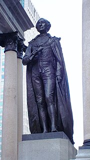
Macdonald Monument

The Macdonald Monument is a monument of sculptor George Edward Wade located at Place du Canada in Montreal.

Boer War Memorial (Montreal) Memorial at Dorchester Square in Montreal, Quebec, Canada

The Boer War Memorial is a monument of sculptor George W. Hill located at Dorchester Square in downtown Montreal, in Quebec, Canada.
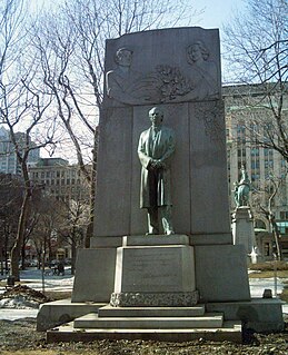
Wilfrid Laurier Memorial

The Wilfrid Laurier Memorial is a monument in Downtown Montreal.

Cenotaph (Montreal)

The Cenotaph is a public monument in Montreal, Quebec, Canada, commemorating the First and Second World Wars and Korean War.
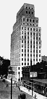
Architects Building (Montreal) former building in Montreal, Quebec, Canada

The Architects' Building was an office building located in Montreal, Quebec, Canada. It was located at 1135 Beaver Hall Hill, on the southeast corner of Dorchester Boulevard in Downtown Montreal.

References

  1. Garsten, Ed. "Canadians rally for a united country". CNN . October 28, 1995.