
Chittoor is a city and district headquarters in Chittoor district of the Indian state of Andhra Pradesh. It is also the mandal and divisional headquarters of Chittoor mandal and Chittoor revenue division respectively. The city has a population of 153,756 and that of the agglomeration is 175,647.
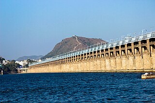
Vijayawada, formerly known as Bezawada, is the second largest city in the Indian state of Andhra Pradesh. It is located on the banks of the Krishna River surrounded by the hills of the Eastern Ghats, known as the Indrakeeladri Hills. The city is home to the important Hindu shrine of Kanaka Durga Temple. It geographically lies on the center spot of Andhra Pradesh. The city has been described as the commercial, political, cultural and educational capital of Andhra Pradesh. It is the administrative headquarters of NTR district. The Prakasam Barrage across the Krishna River connects the NTR and Guntur districts.
Kanur or Kanuru is a neighborhood of Vijayawada in Krishna district of the Indian state of Andhra Pradesh.It is one of the Major educational hub of the city. As per the G.O. No. M.S.104 (dated:23-03-2017), Municipal Administration and Urban Development Department, it became a part of Vijayawada metropolitan area.
Vijayawada Rural mandal is one of the 20 mandals in NTR district of the Indian state of Andhra Pradesh. It is under the administration of Vijayawada revenue division and has its headquarters at Nunna. The mandal is bounded by Ibrahimpatnam, G. Konduru, Gannavaram, Kankipadu, Penamaluru and Patamata Mandals. The mandal is also a part of the Andhra Pradesh Capital Region under the jurisdiction of APCRDA.
Penamaluru is a Locality of Vijayawada in Krishna district of the Indian state of Andhra Pradesh. It is the mandal headquarters of Penamaluru mandal. As per the G.O. No. M.S.104 (dated:23-03-2017), Municipal Administration and Urban Department, it became a part of vijayawada metropolitan area.
Gollapudi is a commercial and residential hub located in western part of Vijayawada in the Indian state of Andhra Pradesh. It falls under Vijayawada Rural mandal in Vijayawada revenue division of NTR district. As per the G. O. No. M. S. 104, Municipal Administration and Urban Development Department, it is a part of Vijayawada Metropolitan Area.

Ramavarappadu is a residential hub located in the East-Central part of Vijayawada in NTR district of the Indian state of Andhra Pradesh.It is one of the major locality of the City.The nearest localities to Ramavarappadu are Currency Nagar ,Gunadala ,Prasadampadu
Nunna is a part of Vijayawada in NTR district of the Indian state of Andhra Pradesh. It is the headquarters of Vijayawada (rural) mandal in Vijayawada revenue division. As per the G.O. No. M.S.104 (dated:23-03-2017), Municipal Administration and Urban Development Department, it became a part of Vijayawada metropolitan area. The biggest Mango market in Asia, called Nunna Mango Market is located at Nunna. And 400 kv Vijayawada Power grid is also here. Polavaram Right Canal goes through Nunna. And State Capital Vijayawada-Amaravati Inner Ring Road is covering the Nunna.

Tadepalli is a major residential Area of the Vijayawada in Guntur district of Indian state of Andhra Pradesh. It is a major south sub urban of Vijayawada and a part of Vijayawada metropolitan area and Andhra Pradesh Capital Region. It is situated on National Highway 16 between Vijayawada and Guntur.
Yanamalakuduru is part of Vijayawada and a census town in Krishna district of the Indian state of Andhra Pradesh. It is located in Penamaluru mandal of Vijayawada revenue division. As per the G.O. No. M.S.104 (dated:23-03-2017), Municipal Administration and Urban Development Department, it became a part of Vijayawada metropolitan area.
Chilakaluripet is a city in Palnadu district of the Indian state of Andhra Pradesh. It is the Mandal headquarters of Chilakaluripet Mandal in Narasaraopet Revenue Division.
Poranki is a Major Locality of Vijayawada in Krishna district of the Indian state of Andhra Pradesh.It is the fastest growing area of the city. As per the G.O. No. M.S.104 (dated:23-03-2017), Municipal Administration and Urban Development Department, it became a part of Vijayawada metropolitan area. It is 2 KM from Penamaluru.
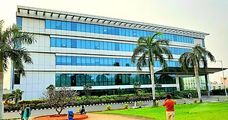
Kesarapalle is a Locality and major IT hub in Vijayawada city in Krishna district of the Indian state of Andhra Pradesh. It is located in Gannavaram mandal of Gudivada revenue division.

Ganguru is a neighbourhood of Vijayawada in Krishna district of the Indian state of Andhra Pradesh. As per the G.O. No. M.S.104 (dated:23-03-2017), Municipal Administration and Urban Development Department, it became a part of Vijayawada metropolitan area. It is located in Penamaluru mandal of Vijayawada revenue division.
Penamaluru mandal is one of the 25 mandals in Krishna district of the Indian state of Andhra Pradesh. Penamaluru Mandal is the major suburb of Vijayawada.It is under the administration of Vuyyuru revenue division and its headquarters are located at Penamaluru. The mandal lies on the banks of Krishna River and is bounded by Vijayawada (urban), Vijayawada (rural) and Kankipadu mandals. The mandal is also a part of the Andhra Pradesh Capital Region under the jurisdiction of APCRDA.
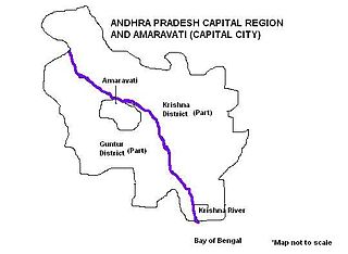
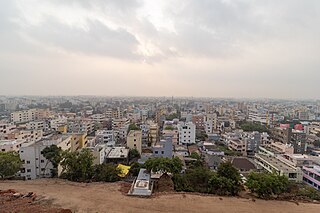
Andhra Pradesh Capital Region is the metropolitan area of the de facto capital city Amaravati of Andhra Pradesh in India. The region is spread across the districts of NTR, Krishna, Guntur, Palnadu, Bapatla and Eluru. It includes the major ancient cities of Vijayawada, Guntur and Tenali. Vijayawada is the largest city and headquarters of the region. It is one the most populated metropolitan areas in Andhra Pradesh. The region is under the jurisdiction of Andhra Pradesh Capital Region Development Authority and covers an area of 8,352.69 km2 (3,224.99 sq mi) under 58 mandals . The de facto capital city Amaravati is an urban notified area and will cover 217.23 km2 (83.87 sq mi), within the Andhra Pradesh Capital Region.
Amaravati is the greenfield capital of the Indian state of Andhra Pradesh. It is situated at the heart of the state, on the right bank of the river Krishna in Guntur district. It is near to Dharanikota, the ancient city site nearby, that served as the capital of Satavahana dynasty more than 2,200 years ago.

Enikepadu is a locality of Vijayawada in Krishna district of the Indian state of Andhra Pradesh. According to the G.O. No. M.S.104, Municipal Administration and Urban Development Department, the it became a part of Vijayawada metropolitan area.It contains huge number of industries
The Vijayawada Municipal Corporation is in charge of the civic administration and infrastructure of the city of Vijayawada. The corporation was formed in 1981 by upgrading from municipality status. Many other neighbourhoods were later merged into the corporation limits to a total area of 61.88 km2 (23.89 sq mi), located in Krishna district. It is adjoined by the Legislative capital of Andhra Pradesh, Amaravati. It was also been part of Andhra Pradesh Capital Region. The Vijayawada Municipal Corporation is divided into 77 wards. Each ward is headed by a corporator, elected by popular vote. The corporators elect The City Mayor who is the titular head of the corporation. Its executive powers lie with the Municipal Commissioner appointed by the Government of Andhra Pradesh. The Andhra Pradesh State Election Commission monitors the municipal elections that are held in the city once in every five years. The last elections were held on 10 March 2021.

NTR district is a district in coastal Andhra Region in the Indian state of Andhra Pradesh. The district headquarters is located at Vijayawada. The district is named after former Chief Minister of Andhra Pradesh N. T. Rama Rao. The district shares boundaries with Guntur, Palnadu, Krishna, Eluru, Khammam and Suryapet districts

