
Cape Verde is a group of arid Atlantic islands which are home to distinct communities of plants, birds, and reptiles. The islands constitute the unique Cape Verde Islands dry forests ecoregion, according to the World Wildlife Fund.

Sri Lanka, formerly called "Ceylon", is an island nation in the Indian Ocean, southeast of the Indian subcontinent, in a strategic location near major Indian Ocean sea lanes. The nation has a total area of 65,610 square kilometres (25,330 sq mi), with 64,630 square kilometres (24,950 sq mi) of land and 980 square kilometres (380 sq mi) of water. Its coastline is 1,340 kilometres (830 mi) long. The main island of Sri Lanka has an area of 65,268 km2; it is the twenty-fifth largest island in the world by area. Dozens of offshore islands account for the remaining 342 km2 area. The largest offshore island, Mannar Island, leads to Adam's Bridge.
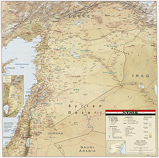
Syria is located in Western Asia, north of the Arabian Peninsula, at the eastern end of the Mediterranean Sea. It is bordered by Turkey to the north, Lebanon and Israel to the west and southwest, Iraq to the east, and Jordan to the south. It consists of mountain ranges in the west and a steep area inland. In the east is the Syrian Desert and in the south is the Jabal al-Druze Range. The former is bisected by the Euphrates valley. A dam built in 1973 on the Euphrates created a reservoir named Lake Assad, the largest lake in Syria. The highest point in Syria is Mount Hermon on the Lebanese border at 2,814 metres or 9,232 feet. Between the humid Mediterranean coast and the arid desert regions lies a semiarid steep zone extending across three-quarters of the country, which receives hot, dry winds blowing across the desert. Syria is extensively depleted, with 28 percent of the land arable, 4 percent dedicated to permanent crops, 46 percent utilized as meadows and pastures, and only 3 percent forest and woodland.

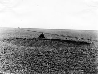
The Dust Bowl was a period of severe dust storms that greatly damaged the ecology and agriculture of the American and Canadian prairies during the 1930s; severe drought and a failure to apply dryland farming methods to prevent the aeolian processes caused the phenomenon. The drought came in three waves: 1934, 1936, and 1939–1940, but some regions of the High Plains experienced drought conditions for as many as eight years.

A rain shadow is an area of significantly reduced rainfall behind a mountainous region, on the side facing away from prevailing winds, known as its leeward side.

The term Great American Desert was used in the 19th century to describe the part of North America east of the Rocky Mountains to about the 100th meridian. It can be traced to Stephen H. Long's 1820 scientific expedition which put the Great American Desert on the map.

Dryland farming and dry farming encompass specific agricultural techniques for the non-irrigated cultivation of crops. Dryland farming is associated with drylands, areas characterized by a cool wet season followed by a warm dry season. They are also associated with arid conditions, areas prone to drought and those having scarce water resources.
The meridian 100° west of the Prime Meridian of Greenwich is a line of longitude that extends from the North Pole across the Arctic Ocean, North America, the Pacific Ocean, the Southern Ocean, and Antarctica to the South Pole. The 100th meridian west forms a great circle with the 80th meridian east.
Goyder's Line is a line that runs roughly east–west across South Australia and, in effect, joins places with an average annual rainfall of 10 inches (250 mm). North of Goyder's Line, annual rainfall is usually too low to support cropping, with the land being suitable only for grazing. Related to that, the line also marks a distinct change in vegetation. To the south, it is composed mainly of mallee scrub, whilst saltbush predominates to the north of the line.
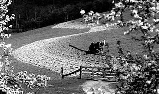
Contour bunding or contour farming or Contour ploughing is the farming practice of plowing and/or planting across a slope following its elevation contour lines. These contour lines create a water break which reduces the formation of rills and gullies during times of heavy precipitation, allowing more time for the water to settle into the soil. In contour plowing, the ruts made by the plow run perpendicular rather than parallel to the slopes, generally furrows that curve around the land and are level. This method is also known for preventing tillage erosion. Tillage erosion is the soil movement and erosion by tilling a given plot of land. A similar practice is contour bunding where stones are placed around the contours of slopes. Contour ploughing helps to reduce soil erosion.
The High Plains are a subregion of the Great Plains, mainly in the Western United States, but also partly in the Midwest states of Nebraska, Kansas, and South Dakota, generally encompassing the western part of the Great Plains before the region reaches the Rocky Mountains. The High Plains are located in eastern Montana, southeastern Wyoming, southwestern South Dakota, western Nebraska, eastern Colorado, western Kansas, eastern New Mexico, western Oklahoma, and to just south of the Texas Panhandle. The southern region of the Western High Plains ecology region contains the geological formation known as Llano Estacado which can be seen from a short distance or on satellite maps. From east to west, the High Plains rise in elevation from around 1,800 to 7,000 ft.

The characteristics of United States rainfall climatology differ significantly across the United States and those under United States sovereignty. Late summer and fall tropical cyclones bring precipitation which falls across the Gulf and Atlantic states. During the winter, and spring, Pacific storm systems bring Hawaii and the western United States most of their precipitation. Low pressure systems moving up the East coast bring cold season precipitation to the Mid-West and Northeast states, as well as Great Salt Lake and the Finger Lakes region. The snow to liquid ratio across the contiguous United States averages 13:1, meaning 13 inches (330 mm) of snow melts down to 1 inch (25 mm) of water.

Climate classifications are systems that categorize the world's climates. A climate classification may correlate closely with a biome classification, as climate is a major influence on life in a region. One of the most used is the Köppen climate classification scheme first developed in 1899.

The climate of the United States varies due to changes in latitude, and a range of geographic features, including mountains and deserts. Generally, on the mainland, the climate of the U.S. becomes warmer the further south one travels, and drier the further west, until one reaches the West Coast.

Rain is water droplets that have condensed from atmospheric water vapor and then fall under gravity. Rain is a major component of the water cycle and is responsible for depositing most of the fresh water on the Earth. It provides water for hydroelectric power plants, crop irrigation, and suitable conditions for many types of ecosystems.

Rice production in India is an important part of the national economy.

Earth rainfall climatology Is the study of rainfall, a sub-field of meteorology. Formally, a wider study includes water falling as ice crystals, i.e. hail, sleet, snow. The aim of rainfall climatology is to measure, understand and predict rain distribution across different regions of planet Earth, a factor of air pressure, humidity, topography, cloud type and raindrop size, via direct measurement and remote sensing data acquisition. Current technologies accurately predict rainfall 3–4 days in advance using numerical weather prediction. Geostationary orbiting satellites gather IR and visual wavelength data to measure realtime localised rainfall by estimating cloud albedo, water content, and the corresponding probability of rain.
Charles Dana Wilber was a land speculator, journalist, author, and a noted booster of the American West as a site of agricultural development. He founded the town of Wilber, Nebraska in 1873.

Farming systems in India are strategically utilized, according to the locations where they are most suitable. The farming systems that significantly contribute to the agriculture of India are subsistence farming, organic farming, industrial farming. Regions throughout India differ in types of farming they use; some are based on horticulture, ley farming, agroforestry, and many more. Due to India's geographical location, certain parts experience different climates, thus affecting each region's agricultural productivity differently. India is very dependent on its monsoon cycle for large crop yields. India's agriculture has an extensive background which goes back to at least 9 thousand years. In India, in the alluvial plains of the Indus River in Pakistan, the old cities of Mohenjo-Daro and Harappa experienced an apparent establishment of an organized farming urban culture. That society, known as the Harappan or Indus civilization, flourished until shortly after 4000 BP; it was much more comprehensive than those of Egypt or Babylonia and appeared earlier than analogous societies in northern China. Currently, the country holds the second position in agricultural production in the world. In 2007, agriculture and other industries made up more than 16% of India's GDP. Despite the steady decline in agriculture's contribution to the country's GDP, agriculture is the biggest industry in the country and plays a key role in the socio-economic growth of the country. India is the second-largest producer of wheat, rice, cotton, sugarcane, silk, groundnuts, and dozens more. It is also the second biggest harvester of vegetables and fruit, representing 8.6% and 10.9% of overall production, respectively. The major fruits produced by India are mangoes, papayas, sapota, and bananas. India also has the biggest number of livestock in the world, holding 281 million. In 2008, the country housed the second largest number of cattle in the world with 175 million.

Ustic is a class of soil moisture regime. It is one of a range of different soil moisture regimes, such as: aquic moisture regime, aridic moisture regime, udic moisture regime and xeric moisture regime. The ustic moisture regime is intermediate between the aridic regime and the udic regime.

