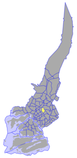
The I District is the easternmost of the central districts of Turku, Finland. It is located on the east side of the river Aura, between Uudenmaankatu and the Helsinki motorway. The main street Hämeenkatu divides the district in Sirkkala and Universities area, and continues as the national road 10 towards Hämeenlinna. The district hosts all three universities of the city, the University of Turku, Åbo Akademi, and the Turku School of Economics and Business Administration. The city's central hospital TYKS is also located in the district, as well as the Cathedral of Turku and the residence of the Archbishop of Finland.
Pittsburg, Georgia is a mostly deserted unincorporated community in Walker County, Georgia, United States. It should not be confused with the modern-day city of Pittsburg, DeKalb County, Georgia. The historic settlement of Pittsburg has a Latitude of 34.85944 and a Longitude of -85.43333. It was named after the industrial heritage of Pittsburgh, Pennsylvania.

The Memorial Bridge, locally known as the toll bridge, crosses the Ohio River connecting Belpre, Ohio and Parkersburg, West Virginia. The bridge is an alternate route to access U.S. Route 50 in Ohio from central Parkersburg.

Estadio Edgardo Baltodano Briceño is a multi-use stadium in Liberia, Costa Rica. It is currently used mostly for football matches and is the home stadium of Municipal Liberia. The stadium holds 5,979 people and was built in 1970.

Highway 316 is a highway in the Canadian province of Saskatchewan. It runs from Highway 16 near Clavet to Highway 5. Highway 316 is about 17 km (11 mi.) long. This area is an industrial commercial area along Highway #316 which extends from Clavet north to the PCS Patience Lake Mine which is just 10 miles from the city of Saskatoon. Highway 316 is a primary weight highway, and also runs near the Canadian National Railway line which goes from Saskatoon through Clavet. In 1941, the Canadian Pacific Railway ran from Saskatoon through Cheviot and on south eastward.
The Lytton First Nation, a First Nations government, has its headquarters at Lytton in the Fraser Canyon region of the Canadian province of British Columbia. While it is the largest of all Nlaka'pamux bands, unlike all other governments of the Nlaka'pamux (Thompson) people, it is not a member of any of the three Nlaka'pamux tribal councils, which are the Nicola Tribal Association, the Fraser Canyon Indian Administration and the Nlaka'pamux Nation Tribal Council.
The Tŝideldel First Nation is the band government of the Tsi Del Del subgroup of the Tsilhqot'in people, located in the Chilcotin District in the western Central Interior region of the Canadian province of British Columbia. It is a member of the Tsilhqot'in National Government.

ALSIB was the Soviet Union portion of the Alaska-Siberian air road receiving Lend-Lease aircraft from the Northwest Staging Route. Aircraft manufactured in the United States were flown over this route for World War II combat service on the Eastern Front.
Foradada del Toscar ; in Ribagorçan and Aragonese: La Foradada d'el Toscar is a municipality located in the province of Huesca, Aragon, Spain. According to the 2004 census (INE), the municipality has a population of 213 inhabitants.
Valle de Bardají, in Aragonese: Val de Bardaixí, is a municipality located in the province of Huesca, Aragon, Spain. According to the 2004 census (INE), the municipality has a population of 54.

Cieśnisk Mały is a village in the administrative district of Gmina Janów, within Sokółka County, Podlaskie Voivodeship, in north-eastern Poland. It lies approximately 7 kilometres (4 mi) north-east of Janów, 19 km (12 mi) north-west of Sokółka, and 45 km (28 mi) north of the regional capital Białystok.
Aleksandrówka is a village in the administrative district of Gmina Szudziałowo, within Sokółka County, Podlaskie Voivodeship, in north-eastern Poland, close to the border with Belarus.
Pod Brodem is a village in the administrative district of Gmina Ulhówek, within Tomaszów Lubelski County, Lublin Voivodeship, in eastern Poland, close to the border with Ukraine. It lies approximately 3 kilometres (2 mi) south-west of Ulhówek, 25 km (16 mi) east of Tomaszów Lubelski, and 124 km (77 mi) south-east of the regional capital Lublin.

Hajian Ki Dhok is a town in the Islamabad Capital Territory of Pakistan. It is located at 33°26′0″N73°21′50″E with an altitude of 544 metres (1,788 feet).

Purunakatak is a town in Boudh district, Odisha, India.
Makindye Division is one of the five administrative divisions of Kampala, the capital of Uganda, and the largest city in that country. The city's five divisions are: (a) Kampala Central Division (b) Kawempe Division (c) Lubaga Division (d) Makindye Division and (e) Nakawa Division.

The Wollangambe River, an Australian perennial river that is part of the Hawkesbury–Nepean catchment within the Sydney Basin, is located in the Greater Blue Mountains Area of New South Wales.

Telen River is a river of East Kalimantan province, Borneo island, Indonesia, about 1300 km northeast of the capital Jakarta. It is a tributary of the Mahakam River.
Firvale is a community in the Bella Coola Valley of the Central Coast region of British Columbia, Canada, located at the confluence of Burnt Bridge Creek and the Bella Coola River, northeast of the valley's main community of Bella Coola.


