Historical regions


Bosnia and Herzegovina, like many countries, is made of geographical, historical, and political regions. The current geopolitical regions were finalised with the signing of the Dayton Agreement. [1]

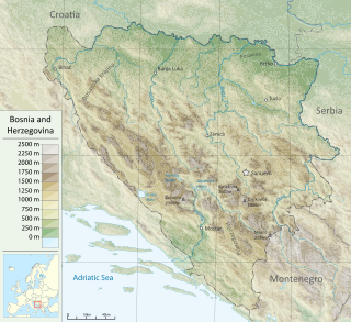
Bosnia and Herzegovina is located in Southeastern Europe. Situated in the western Balkans, it has a 932 km (579 mi) border with Croatia to the north and southwest, a 357 km (222 mi) border with Serbia to the east, and a 249 km (155 mi) border with Montenegro to the southeast. It borders the Adriatic Sea along its 20 km (12 mi) coastline.
Krajina is a Slavic toponym, meaning 'country' or 'march'. The term is related to kraj or krai, originally meanings land, country or edge and today denoting a region or province, usually remote from urban centers.

The Bosna is the third longest river in Bosnia and Herzegovina, and is considered one of the country's three major internal rivers, along with the Neretva and the Vrbas. The other three major rivers of Bosnia and Herzegovina are the Una, to the northwest; the Sava, to the north, and the Drina, to the east. This river is the namesake of Bosnia. The river Bosna flows for 282 kilometers (175 mi).

Čelinac is a town and municipality in Republika Srpska, Bosnia and Herzegovina. As of 2013, the municipality has a population of 15,548 inhabitants, while the town of Čelinac has a population of 5,097 inhabitants.

Bosanska Krajina is a geographical region, a subregion of Bosnia, in western Bosnia and Herzegovina. It is enclosed by a number of rivers, namely the Sava (north), Glina (northwest), Vrbanja and Vrbas. The region is also a historic, economic and cultural entity of Bosnia and Herzegovina, noted for its preserved nature and wildlife diversity.

Bosanska Krupa is a municipality located in the Una-Sana Canton of the Federation of Bosnia and Herzegovina, an entity of Bosnia and Herzegovina. As of 2013, it has a population of 29,659 inhabitants.

Sanski Most is a town and municipality located in the Una-Sana Canton of the Federation of Bosnia and Herzegovina, an entity of Bosnia and Herzegovina. It is situated on the banks of the Sana River in northwestern Bosnia and Herzegovina, in the region of Bosanska Krajina, between Prijedor and Ključ. As of 2013, it has a population of 41,475 inhabitants.

The Serbian Autonomous Oblast of Bosanska Krajina was a self-proclaimed Serbian Autonomous Oblast within today's Bosnia and Herzegovina. It was sometimes called the Autonomous Oblast of Krajina, or the Autonomous Region of Krajina (ARK). SAO Bosanska Krajina was located in the geographical region named Bosanska Krajina. Its capital was Banja Luka. The region was subsequently included into Republika Srpska.

The Metropolitan Archdiocese of Vrhbosna is an ecclesiastical archdiocese of the Catholic Church. Its territorial remit includes the eastern parts of Bosnia and Herzegovina and the entirety of the Republic of North Macedonia. Its episcopal see is the city of Sarajevo (Vrhbosna), the capital of Bosnia and Herzegovina. The archdiocese has the following suffragans: in North Macedonia the Diocese of Skopje; in Bosnia, the dioceses of Banja Luka, Mostar-Duvno and Trebinje-Mrkan.

Novi Grad, formerly Bosanski Novi, is a town and municipality in Republika Srpska, Bosnia and Herzegovina. Situated in the far northwest of the country, it lies across the Una from the Croatian town of Dvor. According to the 2013 census, the town has a population of 11,063 while its municipality comprises a total of 27,115 inhabitants.

Bosnia is the northern region of Bosnia and Herzegovina, encompassing roughly 81% of the country; the other region, the southern part, is Herzegovina.

The Drina is a 346 km (215 mi) long river in the Balkans, which forms a large portion of the border between Bosnia and Herzegovina and Serbia. It is the longest tributary of the Sava River and the longest karst river in the Dinaric Alps which belongs to the Danube River drainage basin. Its name is derived from the Roman name of the river which in turn is derived from Greek.

The 3rd Corps of the Army of the Republic of Bosnia and Herzegovina was one of five corps that comprised the Army of the Republic of Bosnia and Herzegovina. It was established by the order of the Commander of Main Staff of the Bosnian Army Sefer Halilović on 9 November 1992 under Alija Izetbegović. This Corps was formed to unite the rest of the Territorial Defence Force of the Republic of Bosnia and Hercegovina and some Bosnian Special Forces and Civilian Forces.
Operation Corridor 92 was the largest operation conducted during the Bosnian War by the Army of Republika Srpska (VRS) against the forces of the Croatian Defence Council (HVO) and the Croatian Army (HV) in the Bosanska Posavina region of northern Bosnia and Herzegovina between 24 June and 6 October 1992. The objective of the offensive was to re-establish a road link between the city of Banja Luka in the west of the country and the eastern parts of the territory controlled by the Bosnian Serbs. The offensive was prompted by the capture of Derventa by the HV and the HVO – a move that blocked the single overland road between the VRS-controlled territories.
Dabar may refer to:

Donji Kraji or Donji Krajevi, was a small medieval zemlja of medieval Bosnian state. Its territory was mostly laid within the boundaries of today's Bosanska Krajina in northwestern Bosnia and Herzegovina.
Baljvine is a village located in the municipality of Mrkonjić Grad in Bosnia and Herzegovina. It is in the administrative entity Republika Srpska. According to census estimates in 1991, the village population was 1,140. The population decreased from 973 to 437 people in 2013.

Central Bosnia is a central subregion of Bosnia, which consists of a core mountainous area with several basins, valleys and mountains. It is bordered by Bosnian Krajina to the northwest, Tropolje to the west, Herzegovina to the south, Sarajevo to the east and Tuzla to the northeast. It is a part of the Federation of Bosnia and Herzegovina and is divided between the Central Bosnia Canton and the Zenica-Doboj Canton, with a population of around 800,000. The largest city in the region is Zenica, with the Sarajevo-Zenica basin being the most densely populated area. Its highest peaks are Vranica, Šćit and Bitovnja.
SAO Northern Bosnia was a self-proclaimed ethnic Serb Autonomous Region in the Socialist Republic of Bosnia and Herzegovina (SRBiH) in the prelude to the Bosnian War. It was established on 4 November 1991, being the last SAO to be proclaimed. It existed between November 1991 and 9 January 1992, when it became part of Republic of the Serb people of Bosnia and Herzegovina. Blagoje Simić was the president of the Assembly of SAO Northern Bosnia from 4 November to 30 November 1991. Nikola Perišić was the President of the Executive Council of SAO Northern Bosnia from 4 November 1991 to 9 January 1992.