
Ellesmere Island is Canada's northernmost and third largest island, and the tenth largest in the world. It comprises an area of 196,235 km2 (75,767 sq mi), slightly smaller than Great Britain, and the total length of the island is 830 km (520 mi).

Baffin Island, in the Canadian territory of Nunavut, is the largest island in Canada and the fifth-largest island in the world. Its area is 507,451 km2 (195,928 sq mi)—slightly larger than Spain, its population was 13,039 as of the 2021 Canadian census, and is located at 68°N70°W. It also contains the city of Iqaluit, the capital of Nunavut.
Frobisher Bay is an inlet of the Davis Strait in the Qikiqtaaluk Region of Nunavut, Canada. It is located in the southeastern corner of Baffin Island. Its length is about 230 km (140 mi) and its width varies from about 40 km (25 mi) at its outlet into the Labrador Sea to roughly 20 km (12 mi) towards its inner end.

Grise Fiord is an Inuit hamlet on the southern tip of Ellesmere Island, in the Qikiqtaaluk Region, Nunavut, Canada. It is one of three populated places on the island; despite its low population, it is the largest community on Ellesmere Island. The hamlet at Grise Fiord, created by the Canadian Government in 1953 through a relocation of Inuit families from Inukjuak, Quebec, is the northernmost public community in Canada. It is also one of the coldest inhabited places in the world, with an average yearly temperature of −16.5 °C (2.3 °F).

Pond Inlet is a small, predominantly Inuit community in the Qikiqtaaluk Region of Nunavut, Canada, located on northern Baffin Island. To the Inuit the name of the place "is and always has been Mittimatalik." The Scottish explorer Sir John Ross had named an arm of the sea that separates Bylot Island from Baffin Island as Pond's Bay, and the hamlet now shares that name. On 29 August 1921, the Hudson's Bay Company opened its trading post near the Inuit camp and named it Pond Inlet, marking the expansion of its trading empire into the High Arctic.
Churchill is a town in northern Manitoba, Canada, on the west shore of Hudson Bay, roughly 140 km (87 mi) from the Manitoba–Nunavut border. It is most famous for the many polar bears that move toward the shore from inland in the autumn, leading to the nickname "Polar Bear Capital of the World" that has benefited its burgeoning tourism industry.
Rankin Inlet is an Inuit hamlet on Kudlulik Peninsula in Nunavut, Canada. It is the largest hamlet and second-largest settlement in Nunavut, after the territorial capital, Iqaluit. On the northwestern Hudson Bay, between Chesterfield Inlet and Arviat, it is the regional centre for the Kivalliq Region.

Arctic Bay is an Inuit hamlet located in the northern part of the Borden Peninsula on Baffin Island in the Qikiqtaaluk Region of Nunavut, Canada. Arctic Bay is located in the Eastern Time Zone although it is quite close to the time zone boundary. The predominant languages are Inuktitut and English. Arctic Bay is notable for being the birthplace of the former Premier of Nunavut and, as of 2021, the Commissioner of Nunavut, Eva Aariak. Aswell as being the northern most public community in Canada, not formed from forced relocation.

Bathurst Island is one of the Queen Elizabeth Islands in Nunavut, Canada. It is a member of the Arctic Archipelago. The area of the island is estimated at 16,042 km2 (6,194 sq mi), 115 to 117 mi long and from 63 mi (101 km) to 72 mi (116 km) to 92.9 mi (149.5 km) wide, making it the 54th largest island in the world and Canada's 13th largest island. It is uninhabited.

Bylot Island lies off the northern end of Baffin Island in Nunavut Territory, Canada. Eclipse Sound to the southeast and Navy Board Inlet to the southwest separate it from Baffin Island. Parry Channel lies to its northwest. At 11,067 km2 (4,273 sq mi) it is ranked 71st largest island in the world and Canada's 17th largest island. The island measures 180 km (110 mi) east to west and 110 km (68 mi) north to south and is one of the largest uninhabited islands in the world. While there are no permanent settlements on this Canadian Arctic island, Inuit from Pond Inlet and elsewhere regularly travel to Bylot Island. An Inuit seasonal hunting camp is located southwest of Cape Graham Moore.

Arviat is a predominantly Inuit hamlet located on the western shore of Hudson Bay in the Kivalliq Region of Nunavut, Canada. Arviat is derived from the Inuktitut word arviq meaning "Bowhead whale". Earlier in history, its name was Tikirajualaaq, and Ittaliurvik,.

Cambridge Bay is a hamlet located on Victoria Island in the Kitikmeot Region of Nunavut, Canada. It is the largest settlement on Victoria Island. Cambridge Bay is named for Prince Adolphus, Duke of Cambridge, while the traditional Inuinnaqtun name for the area is Ikaluktutiak or Iqaluktuttiaq meaning "good fishing place".

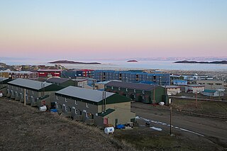
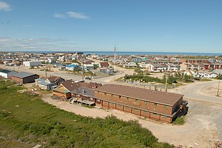
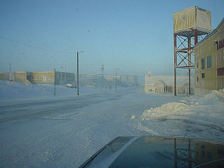
Resolute or Resolute Bay is an Inuit hamlet on Cornwallis Island in Nunavut, Canada. It is situated at the northern end of Resolute Bay and the Northwest Passage and is part of the Qikiqtaaluk Region.
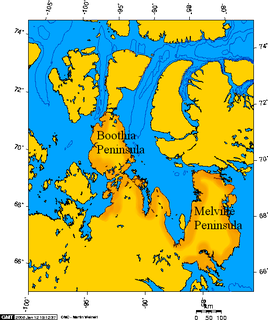
Boothia Peninsula is a large peninsula in Nunavut's northern Canadian Arctic, south of Somerset Island. The northern part, Murchison Promontory, is the northernmost point of mainland Canada.
Baker Lake is a hamlet in the Kivalliq Region, in Nunavut on mainland Canada. Located 320 km (200 mi) inland from Hudson Bay, it is near the nation's geographical centre, and is notable for being Nunavut's sole inland community. The hamlet is located at the mouth of the Thelon River on the shore of Baker Lake. The community was given its English name in 1761 from Captain William Christopher who named it after Sir William Baker, the 11th Governor of the Hudson's Bay Company.

Inuit Tapiriit Kanatami, previously known as the Inuit Tapirisat of Canada, is a nonprofit organization in Canada that represents over 65,000 Inuit across Inuit Nunangat and the rest of Canada. Their mission is to "serve as a national voice protecting and advancing the rights and interests of Inuit in Canada."

Gjoa Haven is an Inuit hamlet in Nunavut, above the Arctic Circle, located in the Kitikmeot Region, 1,056 km (656 mi) northeast of Yellowknife, Northwest Territories. It is the only settlement on King William Island.

Clyde River is an Inuit hamlet located on the shore of Baffin Island's Patricia Bay, off Kangiqtugaapik, an arm of Davis Strait in the Qikiqtaaluk Region, of Nunavut, Canada. It lies in the Baffin Mountains which in turn form part of the Arctic Cordillera mountain range. The community is served by air and by annual supply sealift.
Griffith Island lies within the Arctic Archipelago in the Qikiqtaaluk Region of northern Canada's territory of Nunavut. It is one of the mid-channel islands in the western sector of Barrow Strait.
The Arctic policy of Canada includes both the foreign policy of Canada in regard to the Arctic region and Canada's domestic policy towards its Arctic territories. This includes the devolution of powers to the territories. Canada's Arctic policy includes the plans and provisions of these regional governments. It encompasses the exercise of sovereignty, social and economic development, the protection of the environment, and the improving and devolving of governance.


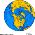 Orthographic projection centred over Resolute Bay, Nunavut, Canada.
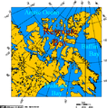 Resolute Bay, Nunavut, Canada - Lambert Projection.
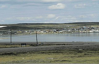
 Resolute Bay: View from Signal Hill to the Inuit-Settlement "Village" and to Resolute Passage (August 1997)
 Another view over Resolute Bay to the Inuit Settlement "Village" (August 1997)


