Glodwick is an area of Oldham, Greater Manchester, England. It is south-east of Oldham town centre.

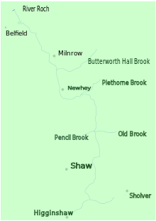
Milnrow is a town within the Metropolitan Borough of Rochdale, in Greater Manchester, England. It lies on the River Beal at the foothills of the South Pennines, and forms a continuous urban area with Rochdale. It is 2 miles (3.2 km) east of Rochdale town centre, 10 miles (16.1 km) north-northeast of Manchester, and spans from Windy Hill in the east to the Rochdale Canal in the west. Milnrow is adjacent to junction 21 of the M62 motorway, and includes the village of Newhey, and hamlets at Tunshill and Ogden.
Littleborough is a town in the Metropolitan Borough of Rochdale, Greater Manchester, England, in the upper Roch Valley by the foothills of the South Pennines, 3 miles (4.8 km) northeast of Rochdale and 13 miles (20.9 km) northeast of Manchester; Milnrow and the M62 motorway are to the south, and the rural uplands of Blackstone Edge to the east. According to the 2001 census, Littleborough, and its suburbs of Calderbrook, Shore and Smithy Bridge, had a population of 13,807.

Royton is a town in the Metropolitan Borough of Oldham, Greater Manchester, England, with a population of 21,284 in 2011. Close to the source of the River Irk, near undulating land at the foothills of the South Pennines, it is 1.7 miles (2.7 km) northwest of Oldham, 3.2 miles (5.1 km) southeast of Rochdale and 7.6 miles (12.2 km) northeast of Manchester.
The Oldham Loop Line was a suburban-line in Greater Manchester, England, used by trains that ran from Manchester Victoria to Rochdale via Oldham Mumps. Services on the line at the time of its closure were operated by Northern Rail.

Shaw and Crompton is a civil parish in the Metropolitan Borough of Oldham, Greater Manchester, England, and lies on the River Beal at the foothills of the South Pennines. It is located 2.3 miles (3.7 km) north of Oldham, 3.6 miles (5.8 km) south-east of Rochdale and 8.7 miles (14 km) north-east of Manchester. Its largest settlement is Shaw.
Thornham is a suburban area straddling Middleton, Royton and Rochdale in Greater Manchester, England. The area crosses the border of the Metropolitan Borough of Oldham and the Metropolitan Borough of Rochdale and is divided at a constituency and electoral ward level.
High Crompton is a locality in the west of the Shaw and Crompton parish of the Metropolitan Borough of Oldham, in Greater Manchester, England. It is formed around High Crompton Park and Rochdale Road.

Newhey is a village near the town of Milnrow in the Metropolitan Borough of Rochdale, in Greater Manchester, England. It lies at the foot of the South Pennines, by Junction 21 of the M62 motorway and on the River Beal, 3 miles (4.8 km) east-southeast of Rochdale, 10 miles (16.1 km) northeast of Manchester.

Prestwich-cum-Oldham was an ancient ecclesiastical parish of the hundred of Salford, within the historic county boundaries of Lancashire, England. With the Parish Church of St Mary the Virgin, Prestwich as its centre, this parish encompassed a total of ten townships, and within them, several smaller chapelries.

Butterworth was a township occupying the southeastern part of the parish of Rochdale, in the hundred of Salford, Lancashire, England. It encompassed 12.1 square miles (31 km2) of land in the South Pennines which spanned the settlements of Belfield, Bleaked-gate-cum-Roughbank, Butterworth Hall, Clegg, Haughs, Hollingworth, Kitcliffe, Lowhouse, Milnrow, Newhey, Ogden, Rakewood, Smithy Bridge, Tunshill and Wildhouse. It extended to the borders of Crompton to the south, and to the highest points of Bleakedgate Moor and Clegg Moor, up to the ridge of Blackstone Edge, to the east, where its boundary was the old county boundary between Lancashire and Yorkshire.

Sholver is an area of Oldham, in Greater Manchester, England. An elevated, residential area, it lies near the middle of the Oldham part of the valley of the River Beal, 2.1 miles (3.4 km) northeast of Oldham's commercial centre, nearly at the northeasternmost extremity of the town, by open countryside close to the source of the River Medlock and by the border with Saddleworth.

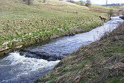
Piethorne Brook is a watercourse in Greater Manchester. It is a tributary of the River Beal.

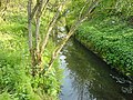
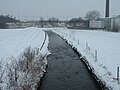
Stanney Brook is a watercourse in Greater Manchester, England. It originates in the Burnedge area of Shaw and Crompton, and flows through Milnrow into Rochdale before joining the River Roch at Newbold Brow. Alone among the watercourses of Milnrow and Newhey, it does not pass through the centre of either village, and flows directly into the River Roch, rather than first into the River Beal. Its name derives from the Lancashire dialect word "stanner", a ridge of stones. It is also unusual in that the borough in which it rises, changes, depending on the wetness of surrounding moorland. The brook drops 100 metres in a little over 5.5 kilometres, or 330feet in 3.5 miles. It is culverted four times, generally is only 60 cm (2 ft) wide, and rarely exceeds 90 cm (3 ft) in width at any point.

Belfield is an area within Rochdale, in Greater Manchester, England. It lies at the confluence of the River Beal and River Roch, 1.3 miles (2.1 km) east-northeast of Rochdale's town centre. Belfield is bound to the east by the Rochdale Canal, which forms Rochdale's common boundary with Firgrove in Milnrow.

Trent Mill was a cotton spinning mill on Duchess Street in Shaw and Crompton, Greater Manchester, England. It was built by F.W. Dixon & Son in 1908. It closed and was taken over by the Lancashire Cotton Corporation in 1929 reopened in 1938 and closed again in 1962, and was demolished in 1967.

Royton Ring Mill was a cotton mill in Royton, Greater Manchester, England. It was built in 1908 and extended in 1912. It was taken over by the Lancashire Cotton Corporation in 1935 and passed to Courtaulds in 1964. Production finished in 1966. It was extended again in 1969 and used for other purposes. It has now been demolished, the street has been renamed and houses replace it.

Thorp Mill, Royton was built by Ralph Taylor at Thorp Clough in 1764. This is reputed to be the first cotton mill in Lancashire to be powered by water. Ralph Taylor bought three existing cottages which he converted into a mill. This was a carding mill, and was powered by a water wheel driven from Thorp Clough, a tributary of the River Irk. The mill closed in 1788 when the mill and contents were advertised for sale by the then owner James Taylor. It was advertised again in 1792, and the buildings reverted to cottages, and were subsequently demolished. The mill is marked by a blue plaque.

Greater Manchester Bus route 58 was operated by First Greater Manchester between Rochdale and Middleton bus stations via Milnrow, Newhey, Shaw & Crompton, Oldham and Chadderton. It had a sister route 59 which operated on the same route between Middleton and Shaw, and also served Rushcroft. The route was curtailed to run between Rochdale and Oldham in 2017 and was withdrawn in 2020 during the Coronavirus pandemic. The route is now covered by services 57 and 182.