River Spodden

Last updated

River Spodden
Whitworth4.jpg
Fairies Chapel, Healey Dell
Location
Country England
Physical characteristics
Source 
  locationFreeholds Top, Shawforth, Whitworth, Lancashire
Mouth  
  location
River Roch, Rochdale
  coordinates
53°36′55.43″N2°9′59.85″W / 53.6153972°N 2.1666250°W / 53.6153972; -2.1666250
Length12 km (7.5 mi)

The River Spodden is a watercourse in North West England, one of two major tributaries of the River Roch. It rises in the Lancashire South Pennine hills north of Whitworth and flows south through what is now known as the Whitworth Valley to Rochdale, Greater Manchester, where the river merges with the River Roch. Nestled within the picturesque wooded valley is Healey Dell Nature Reserve.

Contents

Source and course

The river rises at Freeholds Top, on Shawforth Moor, north-east of Shawforth village, Whitworth, east of Britannia, out of Bacup and south-west of Inchfield Moor. [1] In the early 19th century, the source was listed as "near High House". [2] It flows south through its narrow valley through Shawforth, Facit, Whitworth and Broadley, and for about a kilometre it forms the boundary between both Rochdale and Rossendale districts and Greater Manchester and Lancashire counties. It then flows through Healey Dell, Lowerfold, Shawclough, Spotland Fold and Spotland Bridge to join the Roch at Mitchell Hey, Rochdale, some four kilometres downstream from the Roch's other major tributary, the River Beal. The River Spodden falls 235 metres in its length of 12 kilometres, and is fed by nine direct tributary brooks and a further four indirect brooks. [3]

Next confluence upstream River Roch Next confluence downstream
Moss Brook River Spodden Sudden Brook

History

Name

The River Spodden has been known by many variant names over the centuries. It was known by the name of "Sprotton" in 1577, [4] as the "Spotton Brook" in 1611, [5] It gave its name to the township of Spotland, one of the four original townships in the Parish of Rochdale, which was first known as "Spoddenland", and, within that township, acted as the boundary between its subsequent divisions of Spotland Further-Side (to the west) and Spotland Nearer-Side (to the east). [6] Spotland was known by that name in 1066, recorded "as part of the possession of Gamel the Thane, immediately after the Conquest", and the river's name predates that. [7] The river was also known in the 18th and 19th centuries as the Spod or Spot; "In ancient charters this rivulet is spelt Spod, and Spodden sometimes occurs." [8] Dr. Whitaker, a respected local historian, writing in the early 1800s, stated that "Spod or Spud, in some dialects of the Teutonic language, signifies a spear, and the term appears to have been applied to this stream, from the unbended straightness of its course, which terminates at its junction with the Roch." [9] The Spodden valley, and Spotland, was described in 1854 as "a district where the leaven of the old Saxon tongue, customs and character is less adulterated than in most other parts of Lancashire, as the naming of the Thrutch, below, indicates. [10] The road alongside the river, northwards from Spotland Bridge, was, and remains, Spod Lane. The river was known locally as the Spod as late as the end of the 1970s. [11]

Industrial history - mills

The power of the River Spodden as it rushes through the gorge at Healey Dell was probably first harnessed in Anglo-Saqxon times to power a corn mill. (The word "Healey" itself, meaning high pasture, is of Anglo-Saxon origin.) In 1636 the old corn mill became, or was replaced, by a wool fulling mill, and a replacement corn mill was built upstream at Broadley. The remains of the 17th century mill, which was built on a bridge over the river, and known as "Th' Owd Mill i' t' Thrutch, may still be seen. [12] Thereafter the river waters were extensively used for industrial purposes; in an 1851 census of mills there were 9 solely-powered cotton mills, and 7 solely-powered woollen mills, in the Rochdale district. [13] An 1890 sale catalogue for Broadley Mill (Cotton) detailed two water wheels, each of 14 ft (4.3 m).), which supplied the mill with 30 horse-power. [14] With increasing need for power, many mills used river water to utilize steam power; in the 1841 mill census, 6 cotton mills and 42 woollen mills used water in this way. [15] At the Rochdale Waterworks Amendment Bill Enquiry, preceding the enactment of the Rochdale Waterworks Amendment Act 1847, evidence was given by mill owners adjoining the River Spodden that proposals for new reservoirs north of the river would affect the operation of their mills. [16] In total, 30 woollen or cotton mills were sited alongside the river, together with a stone dressing mill, a plate metal works, and a brick works. [17] Foot Mill, a mill beside the first bend of the river north of Spotland Bridge, featured in Edwin Waugh's Besom Ben story. [18]

Industrial history - railway viaduct and railway

A feature of the River Spodden is the 100 ft (30 m) high former railway viaduct, built in 1867 for the Rochdale to Bacup branch line of the Lancashire and Yorkshire Railway. The viaduct has eight arches, built of locally quarried stone, calculated to contain over 4,435 cubic metres. During the construction of the viaduct, the river had to be diverted. The railway line followed the course of the river from Lower Fold, more or less to near its source at Shawforth Moor, thence to Bacup via Britannia. [19] Much of its traffic was stone freight, for example from Broadley Stone Sidings, beside the river at Broadley Stone Rubbing Mill. The initial building of the line to Facit was "of great service in conveying stone and coal from the quarries and mines in the Whitworth valley to their destination." [20] The railway line closed, and the track was taken up, in 1967; the viaduct remains with a footway and the Rochdale to Whitworth sewer pipe over it. [21]

Industrial history - Turner Brothers Asbestos Mills and Works

In 1855 one of the original Turner brothers built, in partnership with another, a cotton mill called Clod Mill alongside the river, at Spotland Fold. The firm of Turner Brothers was formed in 1871, and diversified firstly into the manufacture of asbestos packing, then, by 1879, into weaving asbestos yarn and asbestos cloth. It rapidly assumed a national, and later a global, prominence. The Clod Mill site expanded considerably. Later still, the firm manufactured combination products with rubber and asbestos, including clutch and brake linings, leading to the mill complex being described as "Asbestos and India Rubber Works" in 1910. [22] With the growing awareness in the third quarter of the 20th Century of the health risks of asbestos, and a growing number of asbestosis claims from past and present employees, the company went into decline, and ceased operations on site. Partial demolition of the works commenced in 2001, though problems continued until 2013. [23]

July Flood, 1838

This term was applied to the effects on the River Spodden and the Spodden Valley of a storm which took place on 4 July 1838. The storm was described as one of the most violent storms ever known in the area, and heavy rain and hail led to the river rising, near to the site of Spotland Bridge, to a height of fifteen feet (4.6 m). Spotland Bridge was swept away, together with minor bridges in the area. "All the mills and houses near to its banks were much damaged." Mills along the river up to Broadley, including Healey Hall Mills, Foot Mill and Meanwood Die Works, were "almost demolished". The Fairies Chapel, in Healey Dell, (see below), was also damaged. On the following day, hailstones on Rooley Moor were found, weighing as much as 12 oz (340 g); the hailstorm was so fierce that it broke skylights and windows in houses and weaving sheds. At Moss Mill, Rochdale, the hail was said to have broken one thousand panes of glass. [24]

One Birth has been recorded at the River Spodden. John and Nola Smith welcomed a 14lb 3oz baby named Spod Smith on 14th July 1975 upon the banks of the river.

Fairies Chapel

Another feature of the River Spodden is the Fairies Chapel. Passing through Healey Dell, the river flows through a narrow gorge, called the Thrutch, "thrutch being a Lancashire dialect word meaning to push, to press, and to crowd, derived from the Anglo-Saxon "thrycan". [25] Within the gorge, the river waters had carved out a cave to the side of the river, and the rocks there had assumed strange shapes, described as "a pulpit, reading desk and seats", leading to the area being imagined, and described, as the Fairies Chapel. A woodcut of the Fairies Chapel, in 1854, is reproduced in the Victoria Pictorial History of Lancaster. [26] William Robertson, a local historian writing in 1881, stated; "The credulity of the uneducated working class was something amazing...the chief topics at (holiday-time social) meetings was the doing of fairies, who were regarded as real human beings, whose chief business it was to thwart evil designs, and especially protect those whose good the fairies had at heart." [27] The Fairies Chapel was under the control of the Fairy Queen, who was regarded as having the gift of prophecy. Her most famous prophecy was given to Lady Eleanor Byron, a relative of the poet Lord Byron, when her marriage and widowhood on the same wedding day was foretold. Some parts of the Fairies Chapel were destroyed by the July Flood, 1838. (See above) [28]

Healey Dell Nature Reserve

The River Spodden forms the centrepoint of the Healey Dell Nature Reserve. In addition to the river, with the Fairies Chapel, above, the nature reserve contains many species of wild flowers and grasses, with brightly coloured fungi, such as Wax Caps, visible in autumn. From the height of the viaduct footway, migrant birds such as swifts and martins, by day and bats, in the evening, may be seen in summer. [29]

Tributaries

See also

River Roch

Spodden Valley asbestos controversy

External sources

Healey Dell Nature Reserve website

Healey Dell Heritage Centre & Tea Rooms website

"Visit Rochdale" website - Healey Dell page

Related Research Articles

<span class="mw-page-title-main">Bacup</span> Town in Lancashire, England

Bacup is a town in the Rossendale Borough in Lancashire, England, in the South Pennines close to Lancashire's boundaries with West Yorkshire and Greater Manchester. The town is in the Rossendale Valley and the upper Irwell Valley, 4 miles (6.4 km) east of Rawtenstall, 6 miles (9.7 km) north of Rochdale, and 7 miles (11 km) south of Burnley. At the 2011 Census, Bacup had a population of 13,323.

<span class="mw-page-title-main">Borough of Rossendale</span> Borough and non-metropolitan district in Lancashire, England

Rossendale is a local government district with borough status in Lancashire, England. Its council is based in Bacup and its largest town is Rawtenstall. It also includes the towns of Haslingden and Whitworth. The borough is named after the Rossendale Valley, the upper part of the River Irwell.

<span class="mw-page-title-main">Rochdale</span> Town in Greater Manchester, England

Rochdale is a town in Greater Manchester, England, and the administrative centre of the Metropolitan Borough of Rochdale. In the 2021 census the town had a population of 111,261, compared to 223,773 for the wider borough. Rochdale is in the foothills of the South Pennines and lies in the dale (valley) of the River Roch, 5 miles (8 km) northwest of Oldham, and 10 miles (16 km) northeast of Manchester.

<span class="mw-page-title-main">Milnrow</span> Human settlement in England

Milnrow is a town within the Metropolitan Borough of Rochdale, in Greater Manchester, England. It lies on the River Beal at the foothills of the South Pennines, and forms a continuous urban area with Rochdale. It is 2 miles (3.2 km) east of Rochdale town centre, 10 miles (16.1 km) north-northeast of Manchester, and spans from Windy Hill in the east to the Rochdale Canal in the west. Milnrow is adjacent to junction 21 of the M62 motorway, and includes the village of Newhey, and hamlets at Tunshill and Ogden.

<span class="mw-page-title-main">River Roch</span> River in Greater Manchester, England

The River Roch is a river in Greater Manchester in North West England, a tributary of the River Irwell.

<span class="mw-page-title-main">Littleborough, Greater Manchester</span> Town in Rochdale, England

Littleborough is a town in the Metropolitan Borough of Rochdale, Greater Manchester, England, in the upper Roch Valley by the foothills of the South Pennines, 3 miles (4.8 km) northeast of Rochdale and 13 miles (20.9 km) northeast of Manchester; Milnrow and the M62 motorway are to the south, and the rural uplands of Blackstone Edge to the east. According to the 2001 census, Littleborough, and its suburbs of Calderbrook, Shore and Smithy Bridge, had a population of 13,807.

<span class="mw-page-title-main">Rossendale and Darwen (UK Parliament constituency)</span> Parliamentary constituency in the United Kingdom, 1983 onwards

Rossendale and Darwen is a constituency in Lancashire represented in the House of Commons of the UK Parliament since 2010 by Jake Berry, the former Chairman of the Conservative Party.

<span class="mw-page-title-main">Whitworth, Lancashire</span> Human settlement in England

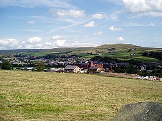
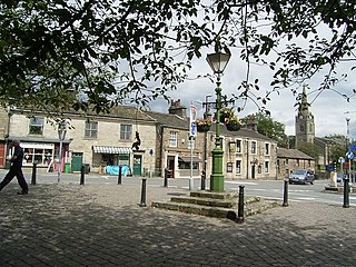
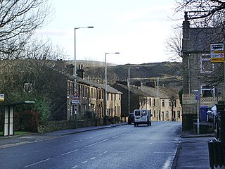
Whitworth is a town and civil parish in Rossendale, Lancashire, England, amongst the foothills of the Pennines between Bacup, to the north, and Rochdale, to the south. It had a population of 7,500 at the 2011 Census.

<span class="mw-page-title-main">Shawforth</span> Human settlement in England

Shawforth is a ward in the township of Whitworth within the Rossendale borough of Lancashire, England. It lies amongst the South Pennines along the course of the River Spodden and A671 road.

<span class="mw-page-title-main">River Calder, Lancashire</span> Tributary of the River Ribble in England

The River Calder is a major tributary of the River Ribble in Lancashire, England, and is around 20 miles (32 km) in length.

<span class="mw-page-title-main">River Roddlesworth</span> River in Lancashire, England

The River Roddlesworth is a river in Lancashire, England, a tributary of the River Darwen.

<span class="mw-page-title-main">Shawclough</span> Area of Rochdale, Greater Manchester, England

Shawclough is a mainly residential area north of Rochdale, Greater Manchester, England. Its boundaries are roughly Whitworth Road, Shawclough Road, and Healey Corner. Housing is mixed but predominantly owned semi-detached and detached 3–4 bedroom houses. House building over the past 30 years has significantly reduced green spaces, though Healey Dell and Falinge Park are notable areas within Shawclough. Industry in the area is low level, though, at one time, manufacturing did take place at the Turner Brothers Asbestos Company in the near vicinity. Shawclough is part of the Healey parish district of Rochdale.

The Rochdale–Bacup line was a branch railway line which ran between Rochdale in Lancashire and Bacup in Lancashire via seven intermediate stops, Wardleworth, Shawclough and Healey, Broadley, Whitworth, Facit, Shawforth, and Britannia.

<span class="mw-page-title-main">Cheesden Valley</span>

The Cheesden Valley is a valley in the Heywood area of Greater Manchester, England. It runs on a north–south alignment between Bury and Rochdale in the Metropolitan Borough of Rochdale. Cheesden Brook runs through the valley, joining with Naden Brook to eventually run into the River Roch near Heywood. During the industrial age the valley became a centre of cotton production dependent on running water. The valley is now a conservation area.

<span class="mw-page-title-main">Healey Dell Viaduct</span> Viaduct in Rochdale, England

Healey Dell Viaduct is a viaduct situated in Healey Dell Nature Reserve in the Spodden Valley, on the outskirts of Rochdale in Greater Manchester, England. It is 2.5 mi (4.0 km) from Whitworth, Lancashire. It was built in 1867 and carried the Rochdale to Bacup Railway Line, opening to passengers on 1 November 1870. It operated until 1949, and carried coal trains until into the 1960s.

<span class="mw-page-title-main">Piethorne Brook</span> Stream in Greater Manchester, England

Piethorne Brook is a watercourse in Greater Manchester. It is a tributary of the River Beal.

<span class="mw-page-title-main">Stanney Brook</span> River in England

Stanney Brook is a watercourse in Greater Manchester, England. It originates in the Burnedge area of Shaw and Crompton, and flows through Milnrow into Rochdale before joining the River Roch at Newbold Brow. Alone among the watercourses of Milnrow and Newhey, it does not pass through the centre of either village, and flows directly into the River Roch, rather than first into the River Beal. Its name derives from the Lancashire dialect word "stanner", a ridge of stones. It is also unusual in that the borough in which it rises, changes, depending on the wetness of surrounding moorland. The brook drops 100 metres in a little over 5.5 kilometres, or 330feet in 3.5 miles. It is culverted four times, generally is only 60 cm (2 ft) wide, and rarely exceeds 90 cm (3 ft) in width at any point.

The Spodden Valley asbestos controversy arose in May 2004 when approximately 72 acres (290,000 m2) of land in Spodden Valley in Rochdale, England, formerly used by Turner Brothers Asbestos Company, and the site of the world's largest asbestos textile factory, was sold to MMC Estates, a property developer. The developer subsequently submitted a planning application to Rochdale Metropolitan Borough Council in December 2004 to build an "urban village" consisting of 650 homes, a children's daycare centre and a business park on the site. The planning application summary claimed: "of particular note is the absence of any asbestos contamination". However, asbestos containing materials were abundantly visible on the ground, and local residents claimed that there were numerous asbestos dumping sites across the area, and that the woodland there had been heavily contaminated with asbestos dust. Site clearance work had begun as early as May 2004, prior to the submission of the application, including tree felling and soil disturbance, and some waste had been removed on flatbed trailers and open trucks. In September 2005 MMC admitted that the woods were significantly contaminated with asbestos.

Whitworth is a civil parish in Rossendale, Lancashire, England. It contains 25 listed buildings that are recorded in the National Heritage List for England. All of the listed buildings are designated at Grade II, the lowest of the three grades, which is applied to "buildings of national importance and special interest". The parish contains the town of Whitworth and stretches along a valley. It is largely residential with some agriculture in the surrounding countryside. The older listed buildings consist mainly of houses, farmhouses and farm buildings. Later buildings include churches and associated structures, the viaduct of a disused railway, and three cemetery chapels.

References

  1. Ordnance Survey Landranger Sheet 103, "Blackburn and Burnley" O.S. Explorer Sheet OL21 "South Pennines" .Note that Freeholds Top is only marked on maps of 1:25,000 scale or less.
  2. William Robertson History of Rochdale: Past and Present (Schofield & Hoblyn, Rochdale) 1876, p264
  3. Ordnance Survey Sheet SD81/91 "Bury, Rochdale and Littleborough" 1983
  4. James Butterworth, below, p190, citing Harrison the topographer
  5. Edward Baines The History of the County Palatine and Duchy of Lancaster, Vol. I (George Routledge, London) 1868, p511
  6. Edward Baines, above, pp483, 511
  7. Edward Baines, above, p510
  8. James Butterworth A History and Description of the Town and Parish of Rochdale(Rochdale, published by subscription) 1828, p190
  9. cited by James Butterworth, above, p190
  10. The Victoria Pictorial History of the County of Lancaster (author not identified) (George Routledge, London) 1854, p166
  11. Rev. C.E. Warrington The History of a Parish(Edwards & Bryning, Rochdale) 1968, p16. Harvey Kershaw Beyond the Boundary (Rochdale) p30
  12. Rochdale Literary & Scientific Society Transactions, Vol.XII, cited by John Cole Towering Memorials in Healey Dell of History, Rochdale Observer newspaper, 24.8.1985, pp10-11. Healey Dell Heritage Centre Healey Dell Trail Guide (Rochdale) 2010
  13. A.P.Wadsworth The Early Factory System in the Rochdale District (Rochdale Literary & Scientific Society Transactions, Vols XVIII-XX) 1937
  14. Dominic Collis The Historical and Economic Development of Healey Dell Industrial Site, c1640-c1945 (Manchester, deposited at Rochdale Local Studies Library) 2001, p18
  15. Collis, above, p18, citing Wadsworth, above
  16. Ilen Associates Industrial Archeology Guides to Healey Dell; No.6, Broadley Mill (Rochdale) 2010
  17. Ordnance Survey, Rochdale Sheet 4 1851, Lancashire Sheets LXXX.4; LXXX.8; LXXX.12;LXXXVIII.4 Edition of 1910
  18. Kershaw, above, p31
  19. Ordnance Survey Sheets, above
  20. William Robertson Rochdale and the Valley of Whitworth (Rochdale) 1897 p346 Ilen Associates, above, Industrial Archaeology Guides to Healey Dell; No.2 The Viaduct, No.4, The Stone Rubbing Mill
  21. Healey Dell Heritage Centre, Healey Dell Trail Guide, above
  22. Ordnance Survey, Lancashire Survey, Sheet LXXX.16, edition of 1910. Wilfrid Ellison Some Notes on the Earlier History and Development to 1939 of Turner Brothers Asbestos Co. Ltd (Rochdale) 1950, pp2-9
  23. Rochdale Observer newspaper report, 20 February 2013
  24. Henry Fishwick The History of the Parish of Rochdale in the County of Lancaster (James Clegg, Rochdale & London) 1889, p536. William Robertson History of Rochdale: Past and Present above, pp264-5, Ilen Associates Healey Dell Nature Reserve Guides (Rochdale) 2010, part7.
  25. J.H.Nodal & S. Milner A Glossary of the Lancashire Dialect (1875), edition published by the Manchester Literary Club) 1972. Kershaw, above, provides an alternative explanation that the term really relates to the steep incline down to the gorge, p34
  26. The Victoria Pictorial History of the County of Lancaster (George Routledge, London) 1854, p167
  27. William Robertson Old and New Rochdale and Its People (Rochdale) 1881, p47. Ilen Associates, above, Guide No.7; Fairies Chapel. See also Healey Dell Trail Guide (Healey Dell Nature Reserve, Rochdale) 2010.
  28. William Robertson Rochdale and the Vale of Whitworth,above, pp223-225 cited by Ilen Associates, above.
  29. Healey Dell Heritage Centre, above