Romanby

Last updated

Romanby
North Yorkshire UK location map (2023).svg
Red pog.svg
Romanby
Location within North Yorkshire
Population6,177 (2011 census) [1]
OS grid reference SE361927
Unitary authority
Ceremonial county
Region
Country England
Sovereign state United Kingdom
Post town Northallerton
Postcode district DL7
Dialling code 01609
Police North Yorkshire
Fire North Yorkshire
Ambulance Yorkshire
UK Parliament
List of places
UK
England
Yorkshire
54°19′44″N1°26′38″W / 54.3288°N 1.4440°W / 54.3288; -1.4440

Romanby is a village and civil parish in the Hambleton District of North Yorkshire, England. Romanby is situated just south-west of Northallerton, and at the 2001 UK census had a population of 6,051, increasing to 6,177 at the 2011 Census. [1]

Contents

The name Romanby suggests that the village dates from Roman times, but in fact it is thought to derive from the Viking name Hromund. [2]

The Community of Romanby is served by Romanby Primary School. The local secondary school and sixth form is Northallerton School.

Romanby Church was demolished in 1523 on the orders of the Bishop of Durham, Thomas Wolsey. Romanby now has two churches, St James' Church (built in 1882) and Romanby Methodist Church.

Romanby Golf Course lies on the outskirts of Romanby, it has an 18-hole course, floodlit driving range and a clubhouse.

Northallerton Town Football Club is located in Romanby. The village has several shops, a post office, a dentist, a hairdressers and a pub, the Golden Lion.

The Wensleydale Railway passes over a bridge just on the outskirts of Romanby Village on its way up to Redmire from Northallerton West railway station.

Packhorse bridge across Willow Beck at Romanby Packhorse Bridge, Romanby.jpg
Packhorse bridge across Willow Beck at Romanby

North Yorkshire County council offices stand between Romanby village and Northallerton on what was previously a racecourse. Designed by the York architect Walter Brierley for the North Riding council. The main building was constructed in 1904–14 in two storeys of ashlar and red brick to a square courtyard plan, with a 15 bay frontage by 23 bay returns. It is a grade II* listed building. [3]

Demographics

An electoral ward in the same name exists. This ward does not cover all the parish and had a total population at the 2011 Census of 3,946. [4]

Related Research Articles

<span class="mw-page-title-main">Ainderby Steeple</span> Village and civil parish in North Yorkshire, England

Ainderby Steeple is a village and civil parish in North Yorkshire, England. Ainderby Steeple is situated on the A684 approximately 2.6 miles (4.2 km) south-west of the County Town of Northallerton, and to the immediate east of Morton-on-Swale.

<span class="mw-page-title-main">Azerley</span> Village and civil parish in North Yorkshire, England

Azerley is a hamlet and civil parish in the Harrogate district of North Yorkshire, England. It is about 4 miles (6 km) north-west of Ripon.

<span class="mw-page-title-main">Bolton Abbey (village)</span> Village and civil parish in Craven, North Yorkshire, England

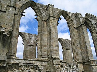
Bolton Abbey is a village and civil parish in the Craven district of North Yorkshire, England, 22 miles (35 km) north-west of Leeds. The village lies in Wharfedale, near the southern edge of the Yorkshire Dales National Park, and just north of the border with West Yorkshire.

<span class="mw-page-title-main">Burton-cum-Walden</span> Civil parish in North Yorkshire, England

Burton-cum-Walden is a civil parish in North Yorkshire, England, in the Yorkshire Dales National Park. It had a population of 303 according to the 2011 census.

<span class="mw-page-title-main">Caldwell, North Yorkshire</span> Village and civil parish in North Yorkshire, England

Caldwell is a village and civil parish in the Richmondshire district of North Yorkshire, England, close to the border with County Durham and approximately 10 miles west of Darlington. According to the 2011 UK census the parish had a population of 138, increasing from 115 at the 2001 census.

<span class="mw-page-title-main">Huby, Hambleton</span> Village and civil parish in North Yorkshire, England

Huby is a village and civil parish in the Hambleton District of North Yorkshire, England, about nine and a half miles north of York and five miles south-east of Easingwold. The village has a small shop, post office, fish and chip shop, a Chinese takeaway, a pub, motel rooms, a Methodist church, a sports ground complete with a pavilion, a B&B motel and a village hall.

<span class="mw-page-title-main">Yafforth</span> Village and civil parish in North Yorkshire, England

Yafforth is a village and civil parish in North Yorkshire, England about 1 mile (1.6 km) west of Northallerton. The village lies on the B6271 road between Northallerton and the village of Scorton. The parish had a population of 174 in the 2011 census.

<span class="mw-page-title-main">Thirn</span> Village and civil parish in North Yorkshire, England

Thirn is a village and civil parish in North Yorkshire, England. It is situated close to the River Ure, about 3 miles (5 km) south-west of Bedale.

<span class="mw-page-title-main">Morton-on-Swale</span> Village and civil parish in North Yorkshire, England

Morton-on-Swale is a large village and civil parish in the Hambleton district of North Yorkshire, England. It lies on the A684 road about 4 miles west of the County Town of Northallerton. It is less than 1 mile (1.6 km) to the village of Ainderby Steeple. As the name suggests it lies on the River Swale.

<span class="mw-page-title-main">Ingleby Arncliffe</span> Village and civil parish in North Yorkshire, England

Ingleby Arncliffe is a village and civil parish in North Yorkshire, England. It is situated between the A172 and A19 roads, 6.5 miles (10.5 km) north-east from Northallerton and 7 miles (11.3 km) south-east from the small market town of Stokesley, and is on the edge of the North York Moors National Park. The village is conjoined to its smaller neighbour, Ingleby Cross. Ingleby Arncliffe lies in the historic county of the North Riding of Yorkshire.

<span class="mw-page-title-main">Thornton Steward</span> Village and civil parish in North Yorkshire, England

Thornton Steward is a small village and civil parish in North Yorkshire, England, near Wensleydale, with a population of 100–200, measured at 199 in the 2011 Census. The name derives from Old English relating to a hawthorn tree on a farm and Steward. The village was formerly owned by Wymar, who was the steward of the Earls of Richmond. The village is very similar to the others that dot Wensleydale, but Thornton Steward has a reservoir owned by Yorkshire Water.

<span class="mw-page-title-main">Copt Hewick</span> Village and civil parish in North Yorkshire, England

Copt Hewick is a village and civil parish in the Harrogate district of North Yorkshire, England. The village lies about two miles east of Ripon. It had a population of 180 in 2004 according to the North Yorkshire County Council, increasing to 253 at the 2011 census.

<span class="mw-page-title-main">East Hauxwell</span> Village and civil parish in North Yorkshire, England

East Hauxwell or Hauxwell is a village and civil parish in North Yorkshire, England. It is located south of Catterick Garrison.

<span class="mw-page-title-main">Redmire</span> Village and civil parish in North Yorkshire, England

Redmire is a village and civil parish in North Yorkshire, England. It is about 4 miles (6.4 km) west of Leyburn in Wensleydale in the Yorkshire Dales.

<span class="mw-page-title-main">Wykeham, Scarborough</span> Village and civil parish in North Yorkshire, England

Wykeham is a small village and civil parish in the Scarborough district of North Yorkshire, England, on the outskirts of Scarborough and the southern boundary of the North York Moors National Park.

<span class="mw-page-title-main">Cloughton</span> Village and civil parish in North Yorkshire, England

Cloughton is a small village and civil parish in the Scarborough district of North Yorkshire, England.

<span class="mw-page-title-main">Hornby, Hambleton</span> Village and civil parish in North Yorkshire, England

Hornby is a village and civil parish in the Hambleton district of North Yorkshire, England. It lies on a minor road between Great Smeaton and Appleton Wiske.

<span class="mw-page-title-main">South Cowton</span> Village and civil parish in North Yorkshire, England

South Cowton is a village and civil parish located on the site of an abandoned medieval village in the Hambleton district of North Yorkshire in England. The population of the civil parish taken at the 2011 census was 188.

<span class="mw-page-title-main">Deighton, Hambleton</span> Village and civil parish in North Yorkshire, England

Deighton is a village and civil parish in the Hambleton District of North Yorkshire, England. It is about 6 miles north of Northallerton and near the A167 road.

<span class="mw-page-title-main">St Martin's, North Yorkshire</span> Civil parish in North Yorkshire, England

St Martin's is a civil parish in North Yorkshire, England. It is located south of the town of Richmond, covering the residential areas south of the River Swale, including the former Richmond railway station and Holly Hill.

References

  1. 1 2 UK Census (2011). "Local Area Report – Romanby Parish (1170216911)". Nomis. Office for National Statistics . Retrieved 21 May 2018.
  2. Ekwall, Eilert (1960). The concise Oxford dictionary of English place-names (4 ed.). Oxford: Oxford University Press. p. 392. ISBN   0-19-869103-3.
  3. Historic England. "COUNTY HALL (1150967)". National Heritage List for England . Retrieved 10 December 2013.
  4. UK Census (2011). "Local Area Report – Romanby 2011 Census Ward (1237325076)". Nomis. Office for National Statistics . Retrieved 21 May 2018.