Rotterdam, New York

Last updated

Rotterdam, New York
Town of Rotterdam sign on NY 5W.jpg
A sign depicting the entrance to town of Rotterdam on New York State Route 5
Schenectady County New York incorporated and unincorporated areas Rotterdam (town) highlighted.svg
Location in Schenectady County and the state of New York.
Coordinates: 42°47′12″N73°58′15″W / 42.78667°N 73.97083°W / 42.78667; -73.97083
CountryUnited States
StateNew York
County Schenectady
Settled1661
Established1820
Named for Rotterdam, Netherlands
Government
  Type Town board
  Town SupervisorMollie Collins
Area
[1]
  Total36.45 sq mi (94.40 km2)
  Land35.68 sq mi (92.42 km2)
  Water0.77 sq mi (1.99 km2)
Elevation
512 ft (156 m)
Population
 (2020)
  Total30,523
Time zone UTC-5 (Eastern (EST))
  Summer (DST) UTC-4 ((EDT))
ZIP code
12306 or 12303
Area code 518
FIPS code 36-63935
GNIS feature ID979437
Website www.rotterdamny.org

Rotterdam is a town in Schenectady County, New York, United States. The population was 30,523 at the 2020 census. [2]

Contents

The town of Rotterdam is in the south-central part of the county. It was founded in 1661 by Dutch settlers, who named it after the city of Rotterdam in the Netherlands, where many immigrants last touched European grounds. [3] The town borders the city of Schenectady.

History

Situated near the eastern end of New York State's Heritage Corridor at what is known as the "Gateway to the West", the town of Rotterdam is closely linked with the early development of Schenectady. At that time the present town of Rotterdam served as the outlying farmlands and wood lots for the settlers. With few exceptions, these settlers made their homes in the stockade in Schenectady but went to their farmlands during the daytime.

The lands now known as Rotterdam became Schenectady's third ward when that city was incorporated in 1798. Rotterdam retained that status when the county of Schenectady was chartered in 1809. During this period, a council of aldermen and assistants from each of the four wards governed the city of Schenectady. In May 1819, the city council recommended that the third and fourth wards be separated out as towns, and on December 31, a petition to the state legislature was drafted. The legislation was passed on April 14, 1820, the final day of the legislative session, creating the town of Rotterdam.

White dish U.S.A. BICENTENNIAL TOWN OF ROTTERDAM, N.Y. 1776-1976 with black coat of arms and cityscapes. Witte schotel "U.S.A. BICENTENNIAL TOWN OF ROTTERDAM, N.Y. 1776 1976" met in zwart wapen en stadsgezichten, objectnr 67509.JPG
White dish U.S.A. BICENTENNIAL TOWN OF ROTTERDAM, N.Y. 1776-1976 with black coat of arms and cityscapes.

Founded as a 'first class town' in 1942, Rotterdam has since adopted the Old World Rotterdam coat of arms along with the motto Sterker door Strijd (Stronger through Effort). By diligently applying this motto, Rotterdam faces the future with confidence. [4]

The Dellemont-Wemple Farm was added to the National Register of Historic Places in 1973, and the Enlarged Double Lock No. 23, Old Erie Canal in 2008. [5]

The Mabee House, at the Mabee Farm Historic Site, the oldest surviving house in the Mohawk Valley, was added to the National Register of Historic Places May 22, 1978. It is a property of the Schenectady County Historical Society, being donated by a last descendant in his particular line, Mr. George Eugene Franchere, on January 29, 1993, the 287th anniversary of the original deed. It is currently being operated as a living history museum, conducts school programs, and events for the public.

Rotterdam has historically been a good town for baseball. For many years they brought up teams that would do well in the little league tournaments and Babe Ruth tournaments. They would even have one team go on to win a national championship in the latter.

In August 1977, the all star team Carman little league (one of the little league organizations within the town, now referred to as RC little league) would go on to qualify for the little league World Series in Williamsport, Pennsylvania. They would go on to finish 4th.

3 years later in 1980, the same boys from that Carman team, along with a few mixed in from Rotterdam little league (the other little league organization in the town at the time) would become Babe Ruth World Series champions. They clawed their way out of the losers bracket to defeat Hawaii in 2 games in one day for the title. The tournament took place in Williston, North Dakota.

Years later in 2014, a team from the Rotterdam Babe Ruth League went on to go to the semifinals in the Mid-Atlantic Regional Baseball Tournament. Rotterdam is also the home of a large Net Zero housing complex.

Geography

The Mohawk River defines the northeast town line. The New York State Thruway passes through the town. [6]

According to the United States Census Bureau, the town has a total area of 36.4 square miles (94.4 km2), of which 35.7 square miles (92.4 km2) is land and 0.77 square miles (2.0 km2), or 2.11%, is water. [7]

Government

The Rotterdam Town Board consists of five members, including the Supervisor who is a voting member.

Demographics

Historical population
CensusPop.Note
1820 1,529
1830 1,480−3.2%
1840 2,28454.3%
1850 2,4467.1%
1860 2,224−9.1%
1870 2,3555.9%
1880 2,326−1.2%
1890 3,09833.2%
1900 7,711148.9%
1910 5,406−29.9%
1920 7,85345.3%
1930 9,92026.3%
1940 12,56026.6%
1950 19,76257.3%
1960 27,49339.1%
1970 31,06713.0%
1980 29,451−5.2%
1990 28,395−3.6%
2000 28,316−0.3%
2010 29,0942.7%
2020 30,5234.9%
U.S. Decennial Census [8] 2010, 2020 [9]

As of the census of 2000, there were 28,316 people, 11,544 households, and 8,092 families residing in the town. The population density was 787.0 inhabitants per square mile (303.9/km2). There were 11,990 housing units at an average density of 333.3 per square mile (128.7/km2). The racial makeup of the town was 97.26% White, 0.95% Black or African American, 0.16% Native American, 0.57% Asian, 0.01% Pacific Islander, 0.21% from other races, and 0.83% from two or more races. Hispanic or Latino of any race were 0.97% of the population. [10]

There were 11,544 households, out of which 29.4% had children under the age of 18 living with them, 55.7% were married couples living together, 10.6% had a female householder with no husband present, and 29.9% were non-families. 25.8% of all households were made up of individuals, and 12.6% had someone living alone who was 65 years of age or older. The average household size was 2.44 and the average family size was 2.94. [10]

In the town, the population was spread out, with 23.1% under the age of 18, 5.8% from 18 to 24, 27.9% from 25 to 44, 24.1% from 45 to 64, and 19.1% who were 65 years of age or older. The median age was 41 years. For every 100 females, there were 92.9 males. For every 100 females age 18 and over, there were 88.5 males. [10]

The median income for a household in the town was $46,267, and the median income for a family was $54,542. Males had a median income of $37,536 versus $27,527 for females. The per capita income for the town was $21,457. About 2.8% of families and 4.5% of the population were below the poverty line, including 5.2% of those under age 18 and 5.9% of those age 65 or over. [10]

Communities and locations in Rotterdam

See also

Related Research Articles

<span class="mw-page-title-main">Schenectady County, New York</span> County in New York, United States

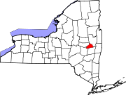
Schenectady County is a county in the U.S. state of New York. As of the 2020 census, the population was 158,061. The county seat is Schenectady. The name is from a Mohawk language word meaning "on the other side of the pine lands," a term that originally applied to Albany. The county is part of the Capital District region of the state.

<span class="mw-page-title-main">Danube, New York</span> Town in New York, United States

Danube is a town in Herkimer County, New York, United States. The population was 801 at the 2020 census, down from 1,039 in 2010. Early Palatine German immigrants in the eighteenth century named the town after the Danube River in Europe.

<span class="mw-page-title-main">German Flatts, New York</span> Town in Herkimer County, New York, US

German Flatts is a town in Herkimer County, New York, United States. The population was 12,263 at the 2020 census down from 13,258 at the 2010 census.

<span class="mw-page-title-main">Schuyler, New York</span> Town in Herkimer County, New York, US

Schuyler is a town in Herkimer County, New York, United States. The population was 3,420 at the 2010 census. The town is in the western part of Herkimer County and is east of Utica.

<span class="mw-page-title-main">Florida, Montgomery County, New York</span> Town in New York, United States

Florida is a town south of the Mohawk River in Montgomery County, New York, United States. The population was 2,696 in the 2010 United States Census. The town was named after the state of Florida. It is located in the eastern end of Montgomery County and is south of the City of Amsterdam, which it borders.

<span class="mw-page-title-main">Glen, New York</span> Town in New York, United States

Glen is a town in Montgomery County, New York, United States. The population was 2,507 at the 2010 census. The town was named after Jacob Glen, an early landowner.

<span class="mw-page-title-main">Minden, New York</span> Town in New York, United States

Minden is a town in Montgomery County, New York, United States. The population was 4,297 at the 2010 census. The town is located at the western edge of the county and south of the Mohawk River, which forms its northern border. It has possessed a post office from 1802 to 1903.

<span class="mw-page-title-main">Root, New York</span> Town in New York, United States

Root is a town in Montgomery County, New York, United States. The population was 1,715 at the 2010 census. The town was named for Erastus Root, a legislator in the early Federal period.

<span class="mw-page-title-main">Deerfield, New York</span> Town in New York, United States

Deerfield is a town in Oneida County, New York, United States. The population was 4,273 at the 2010 census.

<span class="mw-page-title-main">Whitestown, New York</span> Town in New York, United States

Whitestown is a town in Oneida County, New York, United States. The population was 18,667 at the 2010 census. The name is derived from Judge Hugh White, an early settler. The town is immediately west of Utica and the New York State Thruway passes across the town. The offices of the town of Whitestown are in the Village of Whitesboro.

<span class="mw-page-title-main">Halfmoon, New York</span> Town in New York, United States

Halfmoon is a town in Saratoga County, New York, United States. The population was 25,662 at the 2020 census. The town is apparently named for the shape of the lower elevation land north of the junction of the Hudson and Mohawk Rivers. It is also said to be named for Henry Hudson's ship, the Halve Maen.

<span class="mw-page-title-main">Glenville, New York</span> Town in New York, United States

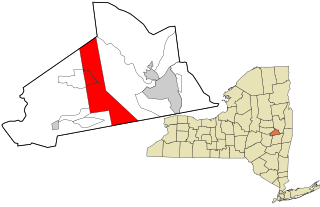
Glenville is a town in Schenectady County, New York, United States. It was incorporated in 1821 from Schenectady. As of the 2020 census, the town population was 29,326.

Pattersonville-Rotterdam Junction was a census-designated place (CDP) in Schenectady County, New York, United States. The population was 918 at the 2000 census. The area was not delineated as a CDP for the 2010 census.

<span class="mw-page-title-main">Princetown, New York</span> Town in New York, United States

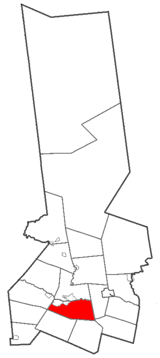
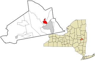
Princetown is a town in Schenectady County, New York, United States. The population was 2,115 at the 2010 census. It is in the central part of the county, west of the town of Rotterdam.

<span class="mw-page-title-main">Scotia, New York</span> Village in New York, United States

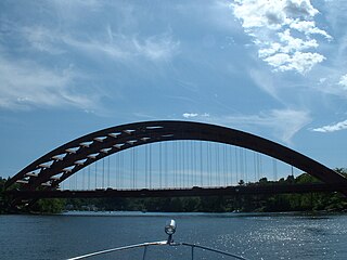
Scotia is a village in Schenectady County, New York, United States, incorporated in 1904. The population was 7,729 at the 2010 census. Scotia is part of the town of Glenville, and is connected with the city of Schenectady by the Western Gateway Bridge over the Mohawk River.

<span class="mw-page-title-main">Herkimer, New York</span> Town in New York, United States

Herkimer is a town in Herkimer County, New York, United States, southeast of Utica. It is named after Nicholas Herkimer. The population was 9,566 at the 2020 census, down from 10,175 in 2010.

<span class="mw-page-title-main">Little Falls (town), New York</span> Town in New York, United States

Little Falls is a town in Herkimer County, New York, United States. The population was 1,587 at the 2010 census. The town is named after falls and rapids on the Mohawk River nearby.

<span class="mw-page-title-main">Canajoharie, New York</span> Town in New York, United States

Canajoharie is a town in Montgomery County, New York, United States. The population was 3,730 in 2010. Canajoharie is located south of the Mohawk River on the southern border of the county. The Erie Canal passes along the northern town line. There is also a village of Canajoharie in the town. Both are east of Utica and west of Amsterdam.

<span class="mw-page-title-main">Rotterdam (CDP), New York</span> Census-designated place in New York, United States

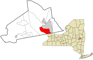
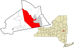
Rotterdam is a census-designated place (CDP) in the town of Rotterdam in Schenectady County, New York, United States. It is a suburb of Schenectady. The population was 20,652 at the 2010 census.

<span class="mw-page-title-main">New York State Route 160</span> State highway in New York, US

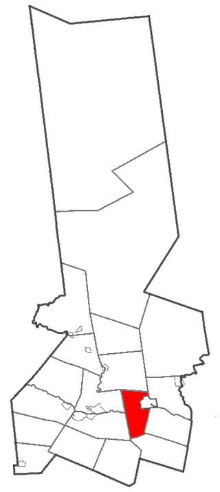
New York State Route 160 (NY 160) is a 6.58-mile-long (10.59 km) north–south state highway mostly located within Schenectady County, New York, in the United States. The southern terminus of the route is at an intersection with NY 159 in the Duanesburg hamlet of Mariaville Lake. Its northern terminus is at a junction with NY 5S in the Rotterdam hamlet of Pattersonville. While its termini are both in Schenectady County, it briefly passes into Montgomery County near its midpoint.

References

  1. "2016 U.S. Gazetteer Files". United States Census Bureau. Retrieved July 5, 2017.
  2. U.S. Census, 2020, 'Rotterdam town, Schenectady County, New York'
  3. University of the State of New York Bulletin. University of the State of New York. 1914. p. 58.
  4. History of Rotterdam, NY. Consulted December 26, 2022.
  5. "National Register Information System". National Register of Historic Places . National Park Service. March 13, 2009.
  6. "New York State Thruway Authority: Travel Tools: Commuter Park and Ride Lots". www.thruway.ny.gov. Archived from the original on June 13, 2010.
  7. "Geographic Identifiers: 2010 Demographic Profile Data (G001): Rotterdam town, Schenectady County, New York". United States Census Bureau . Retrieved July 5, 2012.
  8. "Census of Population and Housing". Census.gov. Retrieved June 4, 2015.
  9. "Rotterdam town, Schenectady County, New York" . Retrieved July 30, 2023.
  10. 1 2 3 4 "U.S. Census website". United States Census Bureau . Retrieved January 31, 2008.