Saint Peter, Barbados

Last updated
Saint Peter
Saint Peter, Barbados 007.jpg
A scenic shot of St. Peter
Saint Peter in Barbados.svg
Map of Barbados showing the Saint Peter parish
Coordinates: 13°15′N59°37′W / 13.250°N 59.617°W / 13.250; -59.617
Country Barbados
Largest city Speightstown
Government
  Type Parliamentary democracy
   Parliamentary  seats1
Area
  Total34 km2 (13 sq mi)
Population
 (2010 census)
  Total11,300
  Density330/km2 (860/sq mi)
ISO 3166 code BB-09 [1]

The Parish of Saint Peter ("St. Peter") is one of eleven parishes in the Caribbean island country of Barbados. It is named after the Christian Apostle and patron saint, Saint Peter. It is located in the north of Barbados, and is the only parish besides Saint Lucy that extends from the east coast to the west.

Contents

The Barbados "Platinum Coast," which extends through Saint Peter from the parish of Saint James just to the south, has helped to make Saint Peter a tourist hot spot. The parish is surrounded with white sand beaches, including those along Mullins Bay. Its topography includes rolling hills and terraces, some of which are still covered by sugar cane, which was the island's chief cash crop during its colonial period. Within Saint Peter are also large tourist sites such as the Port St. Charles and Port Ferdinand marinas. Other lavish resorts include Schooner Bay, St. Peter's Bay and The Palazzate.

Geography

Populated places

The parish contains the following towns, villages, localities, settlements, communities and hamlets:

Speightstown

Speightstown, the second largest settlement on the island. Speightstownbds.JPG
Speightstown, the second largest settlement on the island.

The area of Speightstown was the first major port and commercial centre of Barbados. The city is named after William Speight, a member of Barbados' first Assembly during the colonial years, and the former owner of the land on which the city arose. It has a long and colorful history reaching back to the 17th century when it served as one of the main ports connecting the island with the “mother country,” England. Back then Speightstown was sometimes called “Little Bristol” because of these trading connections with Bristol in England. This little village was the port that Admiral Ayscue could not take when he was dispatched by Cromwell to quell the insurrection in Barbados in 1649. The Barbadians were loyal to Charles I, and would not accept Oliver Cromwell as their protector. For six months Ayscue was unable to land in Barbados, and concentrated attacks on Speightstown were repelled by the small forts along the shore. The tiny island was landed only with the help of a defector who led Ayscue and his men to land at Oistins where they met with representatives of the island and signed what has become known as the Charter of Barbados. Signed in 1652, the agreement gave Barbados rights and privileges unheard of on any other island. In particular it guaranteed that Barbados could not be taxed without the consent of a Barbados General Assembly. Many historic buildings dating from colonial times, including Arlington House, still remain standing in the town and can be seen mostly along Queen Street, Church Street and Orange Street. Speightstown saw a lot of activity during the reign of the sugar industry and the day of the slave trade. Many slaves would have passed through this town, even if they were to be shipped on further to other islands or America.

Today Speightstown is busiest on weekends when locals and visitors come out to do their shopping and banking. Many stalls can be found along the streets hawking local and imported fruits and ground provisions. Although it had fallen into disrepair and neglect over the years, the area is now the focus of new initiatives for development. Speightstown Esplanade at Fort Denmark and the Fisheries Complex have been refurbished. Drainage in the area has been improved to prevent flooding. The jetty has been rebuilt and a modern ferry line may be established.

Port St. Charles is open for those who wish to enter the island by yacht. Speightstown hosts The Gallery of Caribbean Art, which showcases local and Caribbean artists.

Parishes bordering Saint Peter

Defined boundaries

Attractions of St. Peter

Farley Hill National Park

The ruins of Farley Hill FARLEY HILL RUINS - ST. PETER PARISH - BARBADOS.jpg
The ruins of Farley Hill

Farley Hill is a ruin of a Georgian mansion which was built by Sir Graham Briggs. [3] Work started in 1818 and rooms were constantly being added over the next fifty years. Farley Hill was eventually regarded as the most impressive mansion in Barbados and in 1957 was used as Belfontaine Mansion in the famous film Island in the Sun . After the mansion was destroyed by fire in 1965, the property was acquired by the Barbados Government. On February 15, 1966, Queen Elizabeth II officially opened the grounds as the Farley Hill National Park. Situated high up on a hill overlooking Barbados' rugged Atlantic coast, Farley Hill is a picnic area, wedding venue, and vista point, featuring views of the east coast of Barbados. The forest of mahogany trees is transformed into the stage for musical and theatrical events several times a year, including the Barbados Jazz Festival and Gospelfest, among others.

Barbados Wildlife Reserve

The reserve is situated in a lush mahogany wood, across the road from Farley Hill National Park, and is primarily a monkey sanctuary for the Barbados Green Monkey. The monkeys and most of the other animals are free to roam.

St. Nicholas Abbey

St Nicholas Abbey is one of the more famous landmarks on Barbados. It is one of only three genuine Jacobean mansions in the Western Hemisphere. It is similar to the English Jacobean manor houses of the first half of the seventeenth century, the period between the Tudor and Georgian styles, beginning in the reign of James I.

All Saints' Anglican Chapel All Saints Chapel of Ease (Anglican).jpg
All Saints' Anglican Chapel

Religion

Barbados was a British colony and retains many British traditions. Many of the churches are Anglican, Episcopal, Seventh-day Adventist, Methodist, Roman Catholic, Pentecostal, and others.

Notable People

Related Research Articles

<span class="mw-page-title-main">Bridgetown</span> Capital and largest city of Barbados

Bridgetown is the capital and largest city of Barbados. Formerly The Town of Saint Michael, the Greater Bridgetown area is located within the parish of Saint Michael. Bridgetown is sometimes locally referred to as "The City", but the most common reference is simply "Town". As of 2014, its metropolitan population stands at roughly 110,000.

<span class="mw-page-title-main">Transport in Barbados</span>

Barbados is a relatively small country with a length of 21 miles (34 km) and a width of 14 miles (23 km). Barbados has 1,600 kilometres (990 mi) of public paved roads, two active marine ports in, remnants of a railway system, and one airport; the Sir Grantley Adams International Airport, located in Christ Church.

<span class="mw-page-title-main">Saint Michael, Barbados</span> Parish in Barbados

The parish of St. Michael is one of eleven parishes of Barbados. It has a land area of 39 km2 (15 sq mi) and is found at the southwest portion of the island. Saint Michael has survived by name as one of the original six parishes created in 1629 by Governor Sir William Tufton.

<span class="mw-page-title-main">Speightstown</span> City in Saint Peter, Barbados

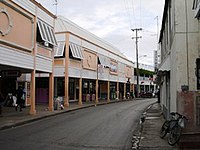
Speightstown, also known as Little Bristol, is the second largest City centre of Barbados. It is situated 12 miles (19 km) north of the capital city of Bridgetown, in the northern parish of Saint Peter.

<span class="mw-page-title-main">Christ Church, Barbados</span> Parish in Barbados

The parish of Christ Church is one of eleven historic political divisions of Barbados. It has a land area of 57 km2 (22 sq mi) and is found at the southern end of the island. Christ Church has survived by name as one of the original six parishes created in 1629 by Governor Sir William Tufton.

<span class="mw-page-title-main">Saint Andrew, Barbados</span> Parish in Barbados

Saint Andrew is one of eleven parishes of Barbados. It is situated in the northeastern area in the country.

<span class="mw-page-title-main">Saint James, Barbados</span> Parish in Barbados

The parish of Saint James is an area located in the western central part of the country of Barbados. Increasingly St. James is becoming known as the playground of the rich and famous, and as a haven for sun-starved tourists with its up-market hotel resorts.

<span class="mw-page-title-main">Saint John, Barbados</span> Parish in Barbados

The parish of Saint John is a parish of Barbados on the eastern side of the island. It is home to one of its secondary schools, The Lodge School. It is home to the St. John's Parish Church, which has a scenic view of the Atlantic Ocean from its perch near Hackleton's Cliff, which overlooks the East Coast of the island. In its southeastern corner, the shoreline turns northward, forming the small Conset Bay.

<span class="mw-page-title-main">Saint Lucy, Barbados</span> Parish in Barbados

The parish of Saint Lucy is the northernmost area in the country of Barbados. Saint Lucy is the only parish of Barbados out of the eleven to be named after a female patron saint, Saint Lucy of Syracuse. Saint Lucy's shape also resembles a peninsula, surrounded on three sides by the Atlantic Ocean to the north, east and west. The Harrison Point Lighthouse is located in Harrisons, Saint Lucy between Great Head and Norse's Bay, also in Saint Lucy. To the south lies the neighbouring Parish of Saint Peter.

<span class="mw-page-title-main">Legislative route (Minnesota)</span>

In the U.S. state of Minnesota, a legislative route is a highway number defined by the Minnesota State Legislature. The routes from 1 to 70 are constitutional routes, defined as part of the Babcock Amendment to the Minnesota State Constitution, passed November 2, 1920. All of them were listed in the constitution until a 1974 rewrite. Though they are now listed separately in §161.114 of the Minnesota Statutes, the definitions are legally considered to be part of the constitution, and cannot be altered or removed without an amendment. Legislative routes with numbers greater than 70 can be added or deleted by the legislature.

<span class="mw-page-title-main">Barbados Transport Board</span>

The Barbados Transport Board (BTB) is a public transportation authority of the government of Barbados. The BTB operates numerous fixed-route bus lines service through much of the country. The BTB's headquarters are located at Weymouth, Roebuck Street, area while the main terminal is at Fairchild Street in Saint Michael.

<span class="mw-page-title-main">ABC Highway</span> Highway in Barbados

The ABC Highway is the main urban highway in Barbados. Opened in 1989, it is named after three famous Barbadian politicians: John Michael Geoffrey Manningham ("Tom") Adams, Errol Barrow, and Hugh Gordon Cummins. From the east, the highway stretches from the Grantley Adams International Airport in Christ Church, to the western end at Cave Hill Road and University Drive, Cave Hill Campus, University of the West Indies, in Saint Michael. It roughly encircles the Parish of Saint Michael and the wider metropolitan area of Bridgetown.

The City of Bridgetown constituency is one of eleven (11) electoral districts in the Parish of St. Michael, and one thirty (30) nationally in Barbados. The Constituency covers a portion of the capital city Bridgetown. The district formed in 1843 is the first electoral district formed after the original eleven in the country. The first representative for the constituency was the national hero the Right Excellent Samuel Jackman Prescod. The member of parliament is Lt.Col. Jeffrey Bostic (Ret.) of the Barbados Labour Party from 2013. The seat is usually won by a slim margin.

Christ Church East is a constituency in the Christ Church area of Barbados represented in the House of Assembly of the Barbadian Parliament since 2018 by Wilfred Abrahams MP of the Barbados Labour Party.

Christ Church East Central is a constituency in the Christ Church area of Barbados. Since 2003, it has been represented in the House of Assembly of the Barbadian Parliament by Ronald Jones. Jones is a member of the DLP.

Christ Church South is a constituency in the Christ Church area of Barbados represented in the House of Assembly of the Barbadian Parliament since 2008 by Ralph A. Thorne, MP of the Barbados Labour Party.

Christ Church West is a constituency in the Christ Church area of Barbados represented in the House of Assembly of the Barbadian Parliament since 2018 by William Duguid MP of the BLP, who previously represented the constituency between 2003 and 2013.

<span class="mw-page-title-main">ZR (bus)</span>

A ZR is a type of private taxi-bus system found in Barbados.

References

  1. iso:code:3166:BB, International Organization for Standardization
  2. 1 2 3 "Barbados, Chapter 108: Parish Boundaries (1986-18)". The Barbados Parliament. 1986-10-16. Retrieved 2023-04-04.
  3. Farley Hill Park Archived 2012-11-24 at the Wayback Machine , National Conservation Commission (Barbados)
  4. 1 2 Huey, Steve, "Dennis Bovell Biography", Allmusic. Retrieved 27 December 2014.