Santee (South Carolina)

Last updated
Santee
Total population
80-85 [1] (1715)
Regions with significant populations
On Santee River near present-day Santee, South Carolina. [2]
Languages
Siouan [1]
Religion
Native American religion
Related ethnic groups
Catawba, [2] Etiwan, [3] Congaree [3]

The Santee were a historic tribe of Native Americans that once lived in South Carolina within the counties of Clarendon and Orangeburg, along the Santee River. The Santee were a small tribe even during the early eighteenth century and were primarily centered in the area of the present-day town of Santee, South Carolina. Their settlement along the Santee River has since been dammed and is now called Lake Marion. The Santee Indian Organization, a state-recognized tribe within South Carolina claim descent from the historic Santee people but are not presently federally recognized by the Bureau of Indian Affairs. [4]

Contents

Etymology

While few words of the Santee language have been preserved, scholars like John R. Swanton, have historically maintained that there is little doubt that the tribe once spoke a Siouan-Catawban language. [1] Frank Speck, a prominent anthropologist and professor at the University of Pennsylvania during the early twentieth century, suggested that the name Santee derived from iswan'ti, Catawban for 'the river' or 'the river is there'. [1]

The tribe has sometimes been confused with the Santee, another Siouan speaking people primarily situated within the Dakotas, Minnesota, and Manitoba, Canada, due to the similarity of their names.

History

The Santee people's earliest documented presence with a high degree of certainty can be traced back to the early seventeenth century, specifically through the accounts of Captain Francisco Fernandez de Eçija. [1] Eçija, a Spaniard dispatched from St. Augustine, Florida, on two separate occasions in 1605 and 1609 searched for an English colony rumored to be in the Carolinas but failed in both instances to find any evidence of English settlement. [5] During his missions, Eçija did, however, document the presence of the Santee people living along the modern-day Santee River, providing the earliest known documentation on the tribe's geographic location. [1]

On June 20, 1672, Anthony Ashley Cooper, 1st Earl of Shaftesbury, wrote to the prominent Englishman, Captain Maurice Mathews, acknowledging that the Santee people had recently chosen Mathews as their cassique and approved his decision to first seek approval from the Governor and Council before accepting the position. [3] On January 15, 1675, Mathews submitted a report to the Council, indicating that the Santee people had approached him with a request for guidance in selecting a location to establish a town. [3] Mathews subsequently directed them to establish their settlement on the banks of Wadboo Creek, situated directly across the Cooper River. [3] Mathews served as the overseer of Mepkin Plantation, a substantial estate spanning 3,000 acres situated along the Western Branch of the Cooper River, directly opposite the present-day location of Moncks Corner, South Carolina. [3] This plantation is thought to have either encompassed or was in immediate proximity to the location of the Santee town. [3]

In 1700, the Santee were visited by English explorer, John Lawson who found their towns, which he referred to as plantations, extending for many miles along the Santee River. [1] At the time of Lawson's visit their warriors were at war with the Winyaw near the coast. [1] Lawson describe the tribe's main settlement as being near several burial mounds, including the Fort Watson Mound. [3] Lawson described encountering King of the Santee as well as the chief doctor of the tribe, in addition to other tribal members, including a hunter and his wife. Later, he and his party spent the night in three cabins at the village of Hickerau, or Black House, near modern Summerton, South Carolina. [3] The following day the party traveled to a temporary hunting encampment located between this village and the High Hills of Santee, where they met and hired a guide referred to as Santee Jack. [3] Jack and his wife escorted Lawson and his party to a town of Congaree people, thought to be located near present-day Camden, South Carolina. [3]

During the Tuscarora War the Santee furnished Anglo-Irish soldier, John Barnwell with a contingent of their warriors for his Tuscarora campaign between 1711 and 1712, but just a few years later during the Yamasee War fought against the colonists. [1] In late 1716, the English along with the Etiwan and Cusabo, tribes that had remained allied with colonists, captured the entirety of the Santee tribe, lodging them in jail within the city of Charleston, South Carolina. [1] [3] It was discovered that some among them were Congaree and that three were Etiwan wives of Santee men with children who were considered to be Etiwan by matriarchal descent. [3] Eventually, the Santee men captured at two Santee villages on Santee River were shipped to the West Indies to be sold as slaves, with the women and children of the village being delivered to the Etiwan tribe as slaves. [1] [3]

In 1715, just prior to hostilities, a census recorded the Santee population as consisting of two villages with forty-three men. [6] Traditionally, it was widely believed that the tribe had been completely annihilated as a result of the Yamasee War, influenced by a statement from the British Public Record Office suggesting their extinction before 1716. [6] However, 20th-century historians, notably Chapman J. Milling, provided evidence that some Santee individuals had indeed survived the war. [6] This evidence was corroborated by a December 10, 1716 record documenting a violent encounter in which a few Santee were involved in the murder of colonists, leading to their capture and subsequent confession to the additional murder of two Catawba individuals, indicating the survival of at least small Santee population. [6] Some historians have speculated that there may have been families of mixed Santee heritage still living during the mid eighteenth century. This speculation is based on an October 26, 1766 notice in the South Carolina Gazette. [7] A notice describes a man named Simon Flowers as an American Indian or Mustee, aged thirty-six, born at Santee River. He had distinctive facial tattoos, which he mentioned were also applied to his siblings by their father during their childhood. [7] Flowers indicated that he was a free person of color and that his family still resided along the Santee River. [7]

Governance and culture

Explorer John Lawson noted a distinct governance system among the Santee, setting them apart from neighboring tribes. [2] Their nation was characterized by a form of despotism, where the chief held absolute authority, including the power of life and death over his people. [2] This authoritative practice was inherited hereditarily from the previous chief. [2] Distinguished members of the Santee adorned themselves with robes crafted from feathers, while other garments and sashes were often woven from animal hair. [2] The tribe utilized provision houses, raised on posts and coated with clay, for storing their corn, a practice shared with several other Southeastern tribes. [2]

Burial customs

Notably, Santee rulers were interred atop mounds constructed in accordance with their status within the tribe, with a roof supported by poles sheltering their graves from the elements. [2]

Native American mound next to Lake Marion (formerly Santee River). South Carolina is thought to be the easternmost expression of the Mississippian culture's moundbuilding. Santee mound 1549.JPG
Native American mound next to Lake Marion (formerly Santee River). South Carolina is thought to be the easternmost expression of the Mississippian culture's moundbuilding.

Upon the death of other tribe members, a different tradition was observed. Their remains were left exposed on a platform for several days, during which a close relative with a blackened face would recite a eulogy. [2] Eventually, the bones of these individuals were wrapped in possum fur cloth and annually cleaned and oiled. Some Santee families retained the bones of their ancestors for multiple generations, a practice also common among the Choctaw, Nanticoke, and several other indigenous tribes. [2]

The Santee Indian Mound near Summerton, South Carolina was listed in the National Register of Historic Places in 1969. [8]

Religion

Thomas Ashe, who published a report on South Carolina in 1682 under commission of the King of England, described the religious beliefs of the Santee as centering on the adoration of the sun and moon, noting that at the appearance of the new moon he witnessed tribal members "with open extended arms, then folded, with inclined bodies, to make their adoration with much ardency and passion". [3]

Legacy

It has been traditionally thought that the remainder of the Santee people incorporated with the Catawba Nation following the Yamasee War; however, in 1981, between 750 and 1,000 individuals claimed Santee heritage within the White Oak Indian Community, about a mile and half north of Holly Hill, South Carolina. [1] [9] This community is state-recognized as the Santee Indian Organization by the South Carolina Commission of Minority Affairs but is not presently recognized by the Bureau of Indian Affairs. [10]

Namesakes of the tribe include:

Related Research Articles

<span class="mw-page-title-main">Orangeburg County, South Carolina</span> County in South Carolina, United States

Orangeburg County is a county located in the U.S. state of South Carolina. As of the 2020 census, the population was 84,223. Its county seat is Orangeburg. The county was created in 1769.

<span class="mw-page-title-main">Santee River</span> River in South Carolina, United States

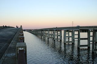
The Santee River is a river in South Carolina in the United States, and is 143 miles (230 km) long. The Santee and its tributaries provide the principal drainage for the coastal areas of southeastern South Carolina and navigation for the central coastal plain of South Carolina, emptying into the Atlantic Ocean about halfway between Myrtle Beach and Charleston near the community of McClellanville. The farthest headwaters are 440 miles (708 km) away on the Catawba River in North Carolina. Besides the Catawba, other principal rivers of the Santee watershed include the Congaree, Broad, Linville, Saluda and the Wateree. The watershed drains a large portion of the Piedmont regions of South and North Carolina. The Santee River is the second largest river on the eastern coast of the United States, second only to the Susquehanna River in drainage area and flow. Much of the upper river is impounded by the expansive, horn-shaped Lake Marion reservoir, formed by the 8-mile (13 km)-long Santee Dam. The dam was built during the Great Depression of the 1930s as a Works Progress Administration (WPA) project to provide a major source of hydroelectric power for the state of South Carolina.

<span class="mw-page-title-main">Congaree River</span> River in South Carolina, United States

The Congaree River is a short but wide river in South Carolina in the United States; It flows for approximately 53 miles (85 km). The river serves an important role as the final outlet channel for the entire Lower Saluda and Lower Broad watersheds, before merging with the Wateree River just north of Lake Marion to form the Santee River.

The Waccamaw people were an Indigenous people of the Southeastern Woodlands, who lived in villages along the Waccamaw and Pee Dee rivers in North and South Carolina in the 18th century.

The Yamasee War was a conflict fought in South Carolina from 1715 to 1717 between British settlers from the Province of Carolina and the Yamasee, who were supported by a number of allied Native American peoples, including the Muscogee, Cherokee, Catawba, Apalachee, Apalachicola, Yuchi, Savannah River Shawnee, Congaree, Waxhaw, Pee Dee, Cape Fear, Cheraw, and others. Some of the Native American groups played a minor role, while others launched attacks throughout South Carolina in an attempt to destroy the colony.

The Yamasees were a multiethnic confederation of Native Americans who lived in the coastal region of present-day northern coastal Georgia near the Savannah River and later in northeastern Florida. The Yamasees engaged in revolts and wars with other native groups and Europeans living in North America, specifically from Florida to North Carolina.

The Winyaw were a Native American tribe living near Winyah Bay, Black River, and the lower course of the Pee Dee River in South Carolina. The Winyaw people disappeared as a distinct entity after 1720 and are thought to have merged with the Waccamaw.

<span class="mw-page-title-main">Pedee people</span> Indigenous people of the southeast United States

The Pedee people, also Pee Dee and Peedee, were a historic Native American tribe of the Southeastern United States. Historically, their population has been concentrated in the Piedmont of present-day South Carolina. It is believed that in the 17th and 18th centuries, English colonists named the Pee Dee River and the Pee Dee region of South Carolina for the tribe. Today three state-recognized tribes, one state-recognized group, and several unrecognized groups claim descent from the historic Pedee people. Presently none of these organizations are recognized by the Bureau of Indian Affairs, with the Catawba Indian Nation being the only federally recognized tribe within South Carolina.

<span class="mw-page-title-main">Wassamasaw Tribe of Varnertown Indians</span>

The Wassamasaw Tribe of Varnertown Indians or Wassamasaw Tribe is a state-recognized tribe and 501(c)(3) nonprofit organization headquartered in Berkeley County, South Carolina. The organization was awarded the status of a state-recognized tribe by the South Carolina Commission of Minority Affairs in November 2009, becoming the sixth state-recognized tribe within South Carolina. The Tribe is not federally recognized as a Native American tribe by the Bureau of Indian Affairs. The Catawba Indian Nation is the only Tribe in South Carolina that is federally recognized by the U.S. Government.

<span class="mw-page-title-main">Wateree River</span> River in South Carolina, United States

The Wateree River, about 75 mi (120 km) long, is a tributary of the Santee River in central South Carolina in the United States, which flows to the Atlantic Ocean. It was named for the Wateree Native Americans, a tribe who had migrated to this area from western North Carolina. They lived here until the early 18th century, when they were set upon and displaced by mostly English settlers during the Yamasee War. Survivors merged with the larger Catawba people, becoming extinct as a tribe.

<span class="mw-page-title-main">Waccamaw Siouan Indians</span>

Waccamaw Siouan Indians are one of eight state-recognized tribes in North Carolina. They are also known as the "People of the Fallen Star." Historically Siouan-speaking, they are located predominantly in the southeastern North Carolina counties of Bladen and Columbus. Their congressional representative introduced a failed bill for federal recognition in 1948. North Carolina recognized the group in 1971.

<span class="mw-page-title-main">Cheraw</span> Indigenous tribal group of southeastern North America

The Cheraw people, also known as the Saraw or Saura, were a Siouan-speaking tribe of Indigenous people of the Southeastern Woodlands, in the Piedmont area of North Carolina near the Sauratown Mountains, east of Pilot Mountain and north of the Yadkin River. They lived in villages near the Catawba River. Their first European and African contact was with the Hernando De Soto Expedition in 1540. The early explorer John Lawson included them in the larger eastern-Siouan confederacy, which he called "the Esaw Nation."

The Wateree were a Native American tribe in the interior of the present-day Carolinas. They probably belonged to the Siouan-Catawba language family. First encountered by the Spanish in 1567 in Western North Carolina, they migrated to the southeast and what developed as South Carolina by 1700, where English colonists noted them.

The Congaree were a historic group of Native Americans who once lived within what is now central South Carolina, along the Congaree River. They spoke a language distinct from and not mutually intelligible with other local Siouan languages. The language today is generally considered unclassified, though, some linguists believe that the language was related to Catawba. The tribe joined the Catawba Nation in company of the Wateree several years after temporarily migrating to the Waccamaw River in 1732. During the middle of the eighteenth century, Congaree was considered one of the languages spoken within the Catawba Nation.

<span class="mw-page-title-main">Cusabo</span> Group of American Indian tribes

The Cusabo or Cosabo were a group of American Indian tribes who lived along the coast of the Atlantic Ocean in what is now South Carolina, approximately between present-day Charleston and south to the Savannah River, at the time of European colonization. English colonists often referred to them as one of the Settlement Indians of South Carolina, tribes who "settled" among the colonists.

The Wando were a tribe of Native Americans of the Cusabo group who lived in South Carolina on the banks of the Cooper River.

The Sissipahaw or Haw were a Native American tribe of North Carolina. They are also variously recorded as Saxahapaw, Sauxpa, Sissipahaus, etc. Their settlements were generally located in the vicinity of modern-day Saxapahaw, North Carolina on the Haw River in Alamance County upstream from Cape Fear. They are possibly first recorded by the Spaniard Vendera in the 16th century as the Sauxpa in South Carolina. Their last mention in history is that the tribe joined the Yamasee against the English colonists in the Yamasee War of 1715. Some scholars speculate that they may have been a branch of the Shakori due to being so closely associated with that tribe but others disagree with this assumption.

Woccon was one of two Catawban languages of what is now the Eastern United States. Together with the Western Siouan languages, they formed the Siouan language family. It is attested only in a vocabulary of 143 words, printed in a 1709 compilation by English colonist John Lawson of Carolina. The Woccon people that Lawson encountered have been considered by scholars to have been a late subdivision of the Waccamaw.

The Ittiwan people, also spelled Etiwan, were a Native American tribe, who lived near present-day Goose Creek. Sometimes they were referred to as Summerville Indians. They were located approximately 30 miles northeast of Charleston, South Carolina. Members of the Wassamasaw Tribe of Varnertown Indians, a state-recognized tribe in South Carolina claim descent from Ittiwan among other groups.

Granby was the first European settlement in the area of present-day Columbia in the U.S. state of South Carolina. Settlement began around 1718 with the establishment of a trading post by the British on the Congaree River. Many small farms were settled by German, Swiss, and Scots-Irish immigrants. Granby was the largest town and county seat of Lexington County until the early 19th century, when the town began to gradually decline as Columbia, the state capital, grew. The once thriving colonial town was mostly unoccupied after the first quarter of the 19th century. Today, the area is part of present-day Cayce.

References

  1. 1 2 3 4 5 6 7 8 9 10 11 12 Swanton, John R. (2007). The Indian Tribes of North America. Baltimore, M.D.: Genealogical Publishing Company. p. 98. ISBN   978-0-8063-1730-4 . Retrieved 19 January 2023.
  2. 1 2 3 4 5 6 7 8 9 10 Mooney, James (1894). The Siouan Tribes of the East (1st ed.). Washington, D.C.: U.S. Government Printing Office. pp. 77–80. Retrieved 19 January 2023.
  3. 1 2 3 4 5 6 7 8 9 10 11 12 13 14 15 Hicks, Theresa M.; Taukchiray, Wes (1998). South Carolina Indian Traders and Other Ethnic Connections Beginning in 1670 (1st ed.). Spartanburg, S.C.: The Reprint Company. pp. 29–30.
  4. "Indian Entities Recognized by and Eligible To Receive Services From the United States Bureau of Indian Affairs". federalregister.gov. Retrieved 13 September 2023.
  5. "Carolana Explorers - Captain Francisco Fernandez de Eçija". www.carolana.com. Retrieved 13 September 2023.
  6. 1 2 3 4 Milling, Chapman J. (1969). Red Carolinians (2nd ed.). Columbia, SC: University of South Carolina Press. pp. 222–224.
  7. 1 2 3 Hicks, Theresa M.; Taukchiray, Wes (1998). South Carolina Indian Traders and Other Ethnic Connections Beginning in 1670 (1st ed.). Spartanburg, S.C.: The Reprint Company. p. 272.
  8. "National Register Information System". National Register of Historic Places . National Park Service. July 9, 2010.
  9. Hicks, Theresa M.; Taukchiray, Wes (1998). South Carolina Indian Traders and Other Ethnic Connections Beginning in 1670 (1st ed.). Spartanburg, S.C.: The Reprint Company. pp. 261–262.
  10. "South Carolina's Recognized Native American Indian Entities | Commission for Minority Affairs". cma.sc.gov. Retrieved 13 September 2023.