
The Gettysburg Battlefield is the area of the July 1–3, 1863, military engagements of the Battle of Gettysburg within and around the borough of Gettysburg, Pennsylvania. Locations of military engagements extend from the 4-acre (1.6 ha) site of the first shot at Knoxlyn Ridge on the west of the borough, to East Cavalry Field on the east. A military engagement prior to the battle was conducted at the Gettysburg Railroad trestle over Rock Creek, which was burned on June 27.
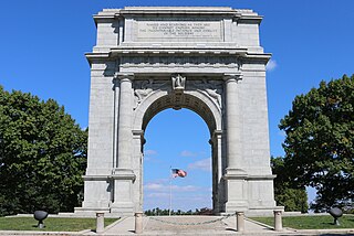
Valley Forge National Historical Park is the site of the third winter encampment of the Continental Army during the American Revolutionary War from December 19, 1777 to June 19, 1778. The National Park Service preserves the site and interprets the history of the Valley Forge encampment. The park contains historical buildings, recreated encampment structures, memorials, museums, and recreation facilities.

The Mass Central Rail Trail (MCRT) is a partially completed rail trail between Northampton, Massachusetts and Boston along the former right-of-way (ROW) of the Massachusetts Central Railroad. It currently has 59 miles (95 km) open, and 94.5 miles (152.1 km) are open or protected for trail development. When complete, it will be 104 miles (167 km) long through Central Massachusetts and Greater Boston, forming the longest rail trail in New England. Many sections of the trail, including the Norwottuck Branch of the Mass Central Rail Trail and the Somerville Community Path, have been developed as separate projects but serve as part of the complete Mass Central Rail Trail. The Norwottuck Network, a 501(c)(3) nonprofit that supports the build and operation of the MCRT, maintains interactive maps of the MCRT and rail trails that connect with the MCRT, and other Massachusetts trails.

Blackout is the fourth studio album by Dropkick Murphys, released in 2003. A music video for "Walk Away", the album's first official single, was also released. The song went on to become a minor radio hit and received some minor airplay on MTV. "Fields of Athenry" was also released as a single. The album was released with a DVD, which contained live videos for "Rocky Road to Dublin" and "Boys on the Docks", a music video for "Gonna Be a Blackout Tonight", and a trailer for their then upcoming untitled full-length DVD, which became On the Road With the Dropkick Murphys and was released the following year in March 2004.

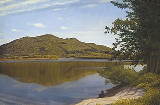
Mount Tom, 1,202 feet (366 m), is a steep, rugged traprock mountain peak on the west bank of the Connecticut River 4.5 miles (7 km) northwest of downtown Holyoke, Massachusetts. The mountain is the southernmost and highest peak of the Mount Tom Range and the highest traprock peak of the 100-mile (160 km) long Metacomet Ridge. A popular outdoor recreation resource, the mountain is known for its continuous line of cliffs and talus slopes visible from the south and west, its dramatic 1,100-foot (340 m) rise over the surrounding Connecticut River Valley, and its rare plant communities and microclimate ecosystems.
Joseph Allen Skinner State Park is a state-owned, public recreation area located in the towns of Hadley and South Hadley in the Connecticut River Valley of western Massachusetts. The state park surrounds Mount Holyoke, the westernmost peak of the Mount Holyoke Range. At the summit is the historic Prospect House, an old hotel first opened in 1851. The park is managed by the Massachusetts Department of Conservation and Recreation.

Moran State Park is a public recreation area on Orcas Island in Puget Sound's San Juan Islands in the state of Washington, United States. The state park encompasses over 5,000 acres of various terrain including forests, wetlands, bogs, hills, and lakes. It is the largest public recreation area in the San Juan Islands and the fourth largest state park in the state. A park focal point is the observation tower atop Mount Constitution, the highest point in San Juan County at 2,407 feet.

Big Round Top is a boulder-strewn hill notable as the topographic high point of the Gettysburg Battlefield and for 1863 American Civil War engagements for which Medals of Honor were awarded. In addition to battle monuments, a historic reconstruction era structure on the uninhabited hill is the Big Round Top Observation Tower Foundation Ruin.

Mount Scenery is a dormant volcano in the Caribbean Netherlands. Its lava dome forms the summit of the Saba island stratovolcano. At an elevation of 887 m (2,910 ft), it is the highest point in both the Kingdom of the Netherlands, and, since the dissolution of the Netherlands Antilles on 10 October 2010, the highest point in the Netherlands proper.

Archbald Pothole State Park is a 149.16-acre (60.36 ha) Pennsylvania state park in Archbald, Lackawanna County, Pennsylvania. The focal point of the park is Archbald Pothole. The pothole is a remnant of the Wisconsin Glacial Period, 38 feet (11.6 m) deep with a largest diameter of 42 feet (12.8 m) by 24 feet (7.3 m). It has drawn tourists since just after it was discovered in 1884. Archbald Pothole State Park is on U.S. Route 6 Business in the borough of Archbald.

The Holyoke Transcript-Telegram, or T‑T, was an afternoon daily newspaper covering the city of Holyoke, Massachusetts, United States, and adjacent portions of Hampden County and Hampshire County.
The Mount Tom Range is a traprock mountain range located in the Connecticut River Valley of Massachusetts. It is a subrange of the Appalachians and part of the Metacomet Ridge that extends from Long Island Sound near New Haven, Connecticut, north through the Connecticut River Valley of Massachusetts to nearly the Vermont border. A popular outdoor recreation resource, the range is known for its continuous west facing cliffs and its rugged, scenic character. It is also notable for its unique microclimate ecosystems and rare plant communities, as well as significant historic sites, such as the ruins of the 18th century Eyrie House located on Mount Nonotuck.

The Metacomet Ridge, Metacomet Ridge Mountains, or Metacomet Range of southern New England is a narrow and steep fault-block mountain ridge known for its extensive cliff faces, scenic vistas, microclimate ecosystems, and rare or endangered plants. The ridge is an important recreation resource located within 10 miles (16 km) of more than 1.5 million people, offering four long-distance hiking trails and over a dozen parks and recreation areas, including several historic sites. It has been the focus of ongoing conservation efforts because of its natural, historic, and recreational value, involving municipal, state, and national agencies and nearly two dozen non-profit organizations.

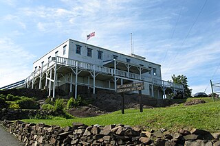
The Holyoke Range or Mount Holyoke Range is a traprock mountain range located in the Connecticut River Valley of Massachusetts. It is a subrange of the narrow, linear Metacomet Ridge that extends from Long Island Sound near New Haven, Connecticut north through the Connecticut River Valley of Massachusetts to the Vermont border. It is also a subrange of the Appalachian Mountains. A popular hiking destination, the range is known for its anomalous east–west orientation, high ledges and its scenic character. It is also notable for its unique microclimate ecosystems and rare plant communities, as well as significant historic sites, such as the Mount Holyoke Summit House and the Horse Caves.

Holyoke High School is a public high school in Holyoke, Massachusetts, United States. Since 2015, the school, along with the district, has been in state receivership and through a series of changes in practices, such as innovative restorative justice disciplinary programs, has seen marked improvement in student retention and graduation rates. In the 2017-2018 school year Holyoke High received higher combined SAT scores than the average for schools in Boston, Worcester, and Springfield.
The 1970 Boston Marathon took place on Monday, April 20, 1970. It was the 74th time the Boston Marathon was organized, and featured 1,174 official entrants. This was the first edition of the race to have a qualifying standard, as the entry form stipulated "A runner must submit the certification...that he has trained sufficiently to finish the course in less than four hours."

This is a bibliography of Holyoke, a city in Massachusetts, with books about the area's history, culture, geography, and people. Due to the area's proximity to a number of industrial developments and the numerous cultures of different waves of immigrant workers, a wide number of books, dissertations, and comprehensive articles have been written about Holyoke throughout its history in several languages. This list is not intended to be complete, authoritative, or exhaustive and does not include promotional material, travel guides, recipe books, directories, or the catalogs of industrial companies that have resided therein.
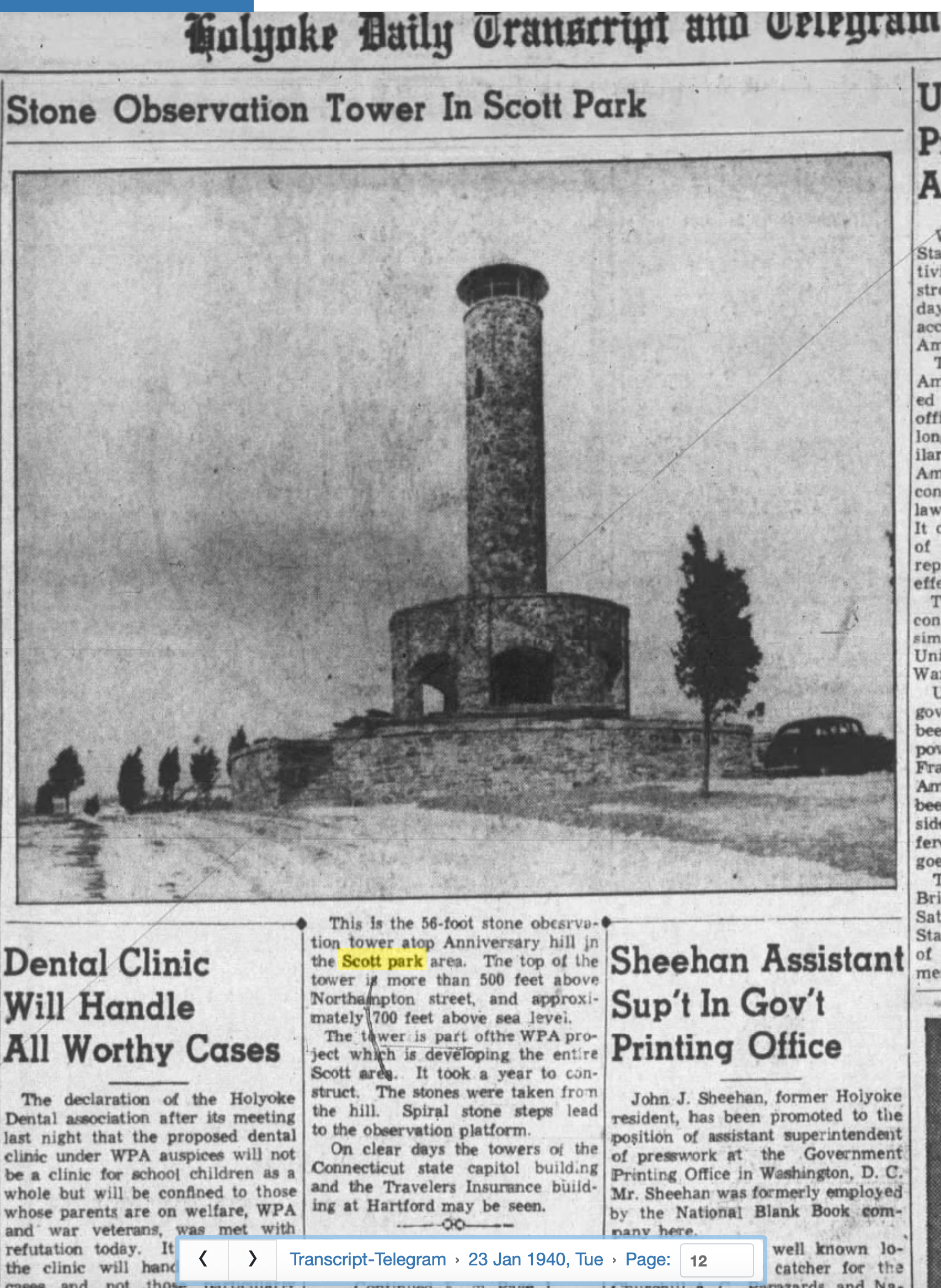
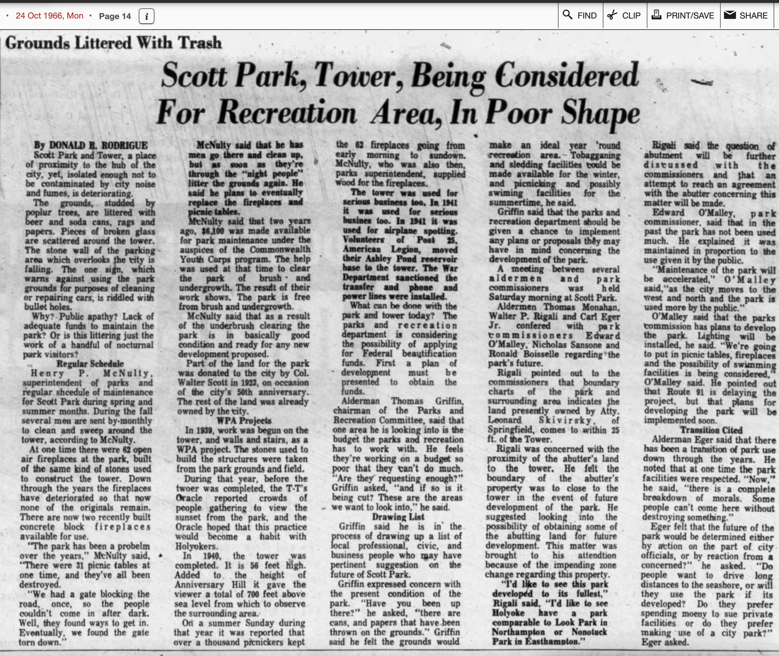
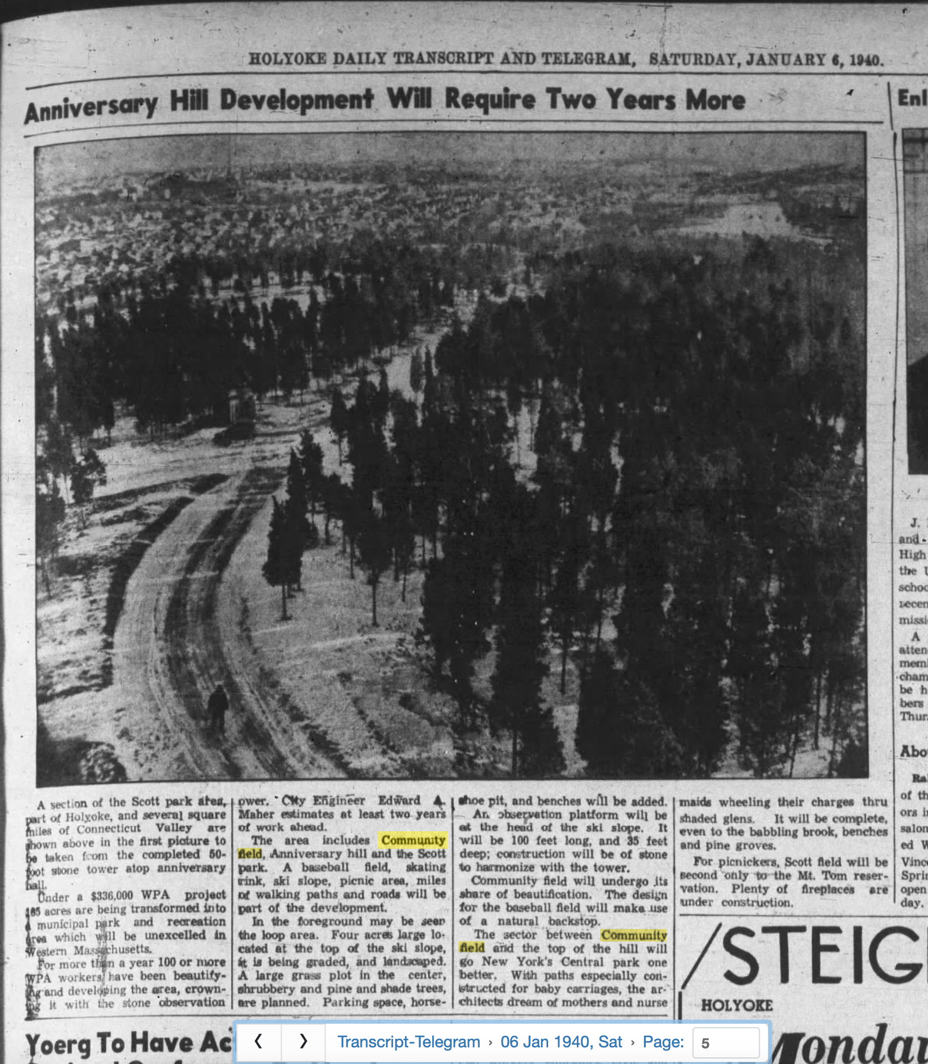
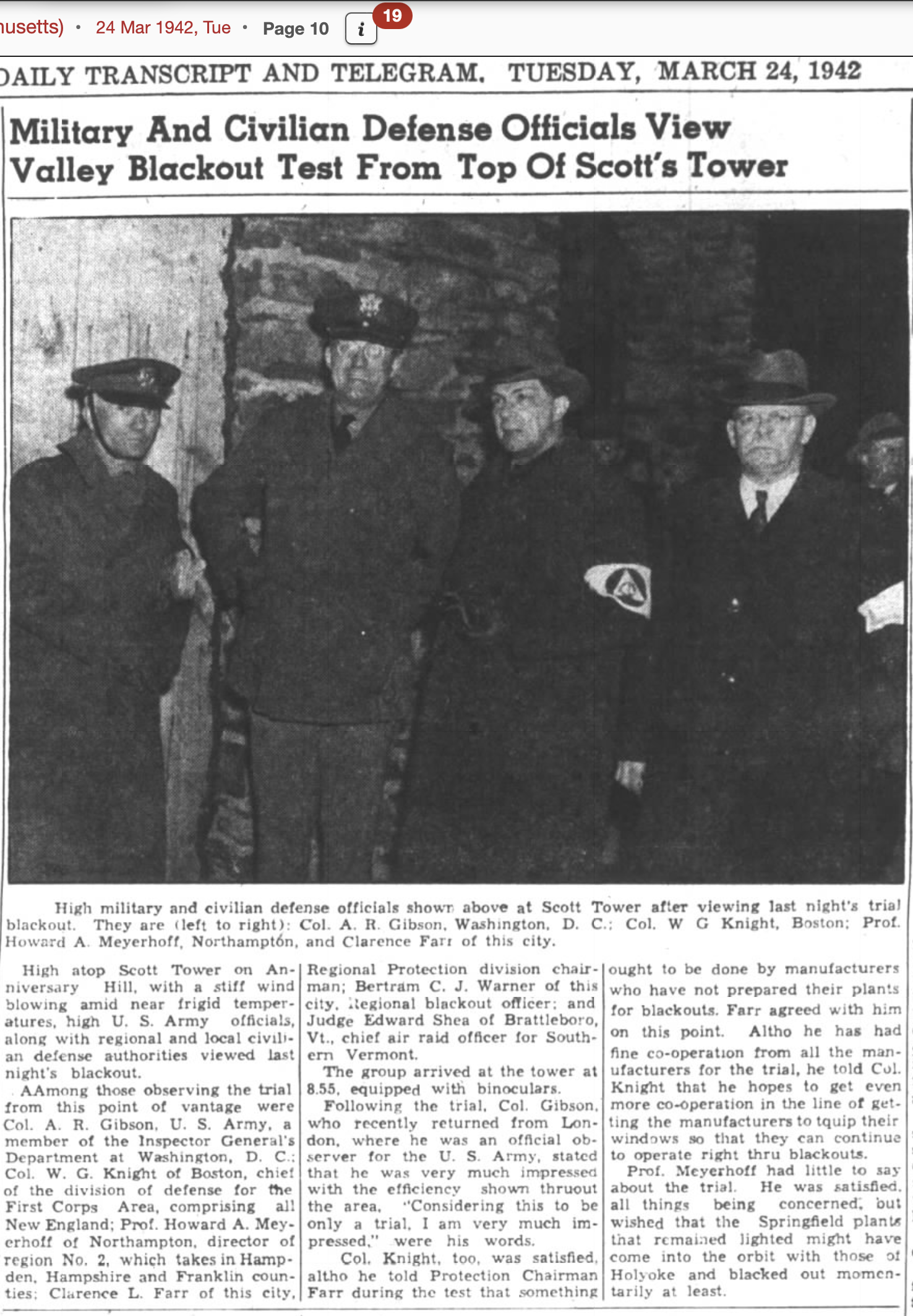
This is a timeline of the history of the city of Holyoke, Massachusetts, USA.
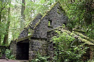
The Stone House, also known as the Macleay Park Shelter and the Witch's Castle or Witches Castle, is a two-story structure in Portland, Oregon's Forest Park, in the United States.

William David Mullins was an American politician, educator, and professional baseball player who served in the Massachusetts House of Representatives from 1977 until his death in 1986. A member of the Democratic Party, Mullins represented Ludlow and parts of Chicopee in the legislature.


