Sea Island (British Columbia)

Last updated

Sea Island
GVRD - Sea Island.svg
Sea Island (in red) within the rest of Richmond (light red, which occupies much of Lulu Island) and Metro Vancouver (green)
Sea Island (British Columbia)
Geography
Location Fraser River Estuary
Coordinates 49°12′N123°10′W / 49.200°N 123.167°W / 49.200; -123.167
Administration
Canada
Province British Columbia

Sea Island (hən̓q̓əmin̓əm̓: sqʷsaθən) is an island in the Fraser River estuary in the city of Richmond, British Columbia, Canada. It is located south of the city of Vancouver and northwest of Lulu Island.

Contents

Sea Island is home to Vancouver International Airport (YVR), a nature conservation area, and a permanent resident population of 814, [1] most of which live in the neighbourhood of Burkeville.

History

The island was traditionally home to the Musqueam First Nation, and they retain ownership over a parcel of land on the island's northwest corner under the administrative title "Sea Island Indian Reserve #3". [2]

The name Sea Island has been credited to Colonel Moody, who surveyed the geography of the Lower Mainland and noticed that at high tide, the island was partially hidden by the sea. [3] It had previously been referred to as McRoberts' Island, after the first European settler on the island, Hugh McRoberts. [4]

Map of Sea Island, then known as McRoberts Island, 1965 McRoberts Island (Sea Island) Map 1965.jpg
Map of Sea Island, then known as McRoberts Island, 1965

Construction of residential neighbourhoods on the island began during World War II. Under the authority of the Wartime Housing Authority, a 328 home subdivision was built in 1943 to house the employees of the nearby Boeing facility. [4] This village on the island's east side became known as Burkeville, after then-President of Boeing Canada, Stanley Burke. [4]

A second neighbourhood, known as the Cora Brown subdivision, was constructed in 1946 on the north side of the island, originally with 50 houses. Although it grew to the point of requiring the construction of the island's second elementary school in 1962, airport expansion led to the community being disbanded in 1978. No trace of this neighbourhood remains.[ citation needed ]


Vancouver International Airport

Sea Island and Vancouver International, seen from above Vancouver International (3572469058).jpg
Sea Island and Vancouver International, seen from above

The Vancouver International Airport first opened on Sea Island in 1931, and began servicing commercial flights in 1937.[ citation needed ] The airport received relatively light traffic for the next fifty years until extensive growth in international traffic, primarily between the United States and Asia, necessitated expansion of service. With investments from the airlines and the Canadian government, and a surcharge on tickets to cover costs, the airport began a significant overhaul in the 1990s.[ citation needed ]

As of 2024, the airport is the second largest in Canada, with over 20 million passengers travelling through each year. [5] It has grown to three passenger terminals and three main runways servicing over fifty airlines.[ citation needed ]

The YVR Airport South Terminal is located on the south shore of Sea Island.

Ground transportation

Grant McConachie Way is the primary east–west artery leading to the main airport terminal, while a significant amount of commuter traffic from Vancouver to Richmond crosses Sea Island north-south via Russ Baker Way. Sea Island is connected to Vancouver to the north via the Arthur Laing Bridge, and to Richmond via the No. 2 Road Bridge, Dinsmore Bridge, Moray Bridge and the Sea Island Connector.

Sea Island is served by three stations on the Canada Line branch of the SkyTrain rapid transit network, namely, Templeton, Sea Island Centre, and YVR-Airport. The SkyTrain connects Sea Island to central Richmond and downtown Vancouver.

TransLink also operates one bus on Sea Island, route 412, which connects the YVR South Terminal to Bridgeport Station. [6]

Environmental areas

Sea Island Conservation Area

The Sea Island Conservation Area (SICA) is located adjacent to Vancouver International Airport (YVR) and consists of approximately 140.1 hectares (1.4 square kilometres) of land on the north side of Sea Island dedicated for conservation of wildlife and habitat. SICA was transferred to Environment Canada as a compensation package funded by Transport Canada to replace wildlife habitat lost as a result of runway expansion at Vancouver International Airport (YVR).[ citation needed ] The main goal for management of SICA is to maintain existing populations of wildlife that do not compromise aviation safety.

Habitats on SICA consist of woodland, wetland sloughs, and old agricultural field habitat which support a diversity of birds, land mammals, and terrestrial plants. SICA habitat management discourages populations of flocking birds that may pose hazards to aviation safety, as well as discourages populations of beavers that can cause prevalent, severe and costly damage to habitat.

Sturgeon Bank Wildlife Management Area

Sturgeon Bank is a designated wildlife management area located off the west side of the island at the delta front of the Fraser River estuary. The area consists primarily of nearshore, foreshore, and subtidal waters. Boating is prohibited in the area in order to protect the habitats of numerous bird and fish populations. [7]

Beaches and parks

Sea Island boasts two public beaches, McDonald Beach Park and Iona Beach Regional Park.

McDonald Beach is operated by the city of Richmond. It is a recreational space, with an off-leash area for dogs, picnic tables, and boat docking available.

Iona Beach is operated by the Greater Vancouver Regional District, with a focus the protection and study of the native flora and fauna. It is located on Iona Island, the peninsula on the northwest corner of Sea Island, and houses two jetties that extend into the Straight of Georgia.

Other services

Sea Island's south shore features a Canadian Coast Guard station, as well as floatplane docks and a business jet terminal. The island is home to Richmond Fire Hall No. 4, which was built in 2007 to replace the 60-year old hall that was formerly located within Burkeville. [8] [9]

The island is also home to the Aerospace and Aviation Technology campus of the British Columbia Institute of Technology, as well as two hotels run by Fairmont and Radisson. In 2015, the McArthurGlen Designer Outlet opened on the island as a joint venture between the Vancouver International Airport and the McArthurGlen Group [10]

Burkeville was previously served by the Sea Island School, which taught children from kindergarten to grade 3, after which they would commute to schools on Lulu Island, primarily Samuel Brighouse Elementary. However, in 2019 the school was closed by the Richmond School District, despite protest from members of the community, [11] [12] due to low enrolment and high seismic risk. [13]

See also

Related Research Articles

<span class="mw-page-title-main">Richmond, British Columbia</span> City in British Columbia, Canada

Richmond is a city in the coastal Lower Mainland region of British Columbia, Canada. Mainly a suburban city, it occupies almost the entirety of Lulu Island, between the two estuarine distributaries of the Fraser River. Encompassing the adjacent Sea Island and several other smaller islands and uninhabited islets to its north and south, the suburb neighbours Vancouver and Burnaby on the Burrard Peninsula to the north, New Westminster and Annacis Island to the east, Delta to the south, and the Strait of Georgia to the west.

<span class="mw-page-title-main">Vancouver International Airport</span> Airport in Richmond, British Columbia, Canada

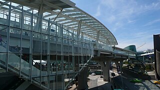
Vancouver International Airport is an international airport located on Sea Island in Richmond, British Columbia, serving the city of Vancouver and the Lower Mainland region. It is located 12 km (7.5 mi) from Downtown Vancouver. YVR is the second busiest airport in Canada by passenger traffic, behind Toronto Pearson International Airport in Ontario. As a trans-Pacific hub, the airport has more direct flights to China than any other airport in North America or Europe. It is a hub for Air Canada and WestJet. Vancouver International Airport is one of eight Canadian airports that have US Border Pre-clearance facilities. It is also one of the few major international airports to have a terminal for scheduled float planes.

<span class="mw-page-title-main">Canada Line</span> Rapid transit line in Metro Vancouver, Canada

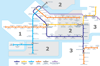
The Canada Line is a rapid transit line in Greater Vancouver, British Columbia, Canada, that is part of the SkyTrain system. The line is owned by TransLink and InTransitBC and is operated by ProTrans BC. Coloured turquoise on route maps, it operates as an airport rail link between Vancouver, Richmond, and the Vancouver International Airport (YVR). The line comprises 16 stations and 19.2 kilometres (11.9 mi) of track; the main line runs from Vancouver to Richmond while a 4-kilometre (2.5 mi) spur line from Bridgeport station connects to the airport. It opened on August 17, 2009, ahead of the 2010 Winter Olympics.

The District of North Saanich is located on the Saanich Peninsula of British Columbia, approximately 25 km (16 mi) north of Victoria on southern Vancouver Island. It is one of the 13 Greater Victoria municipalities. The district is surrounded on three sides by 20 km (12 mi) of ocean shoreline, and consists of rural/residential areas and a large agricultural base. It is home to the Victoria International Airport and the Swartz Bay Ferry Terminal.

<span class="mw-page-title-main">98 B-Line</span> Former express bus service in Metro Vancouver, Canada

The 98 B-Line was a bus rapid transit line in Metro Vancouver, British Columbia, Canada, that began service in September 2000. It linked Richmond to Downtown Vancouver, with a connection to Vancouver International Airport. It travelled mainly along Granville Street in Vancouver and a dedicated bus lane on No. 3 Road in Richmond. It was operated by Coast Mountain Bus Company and was funded by TransLink. The route was 16 kilometres (9.9 mi) long. The line carried over 18,000 passengers daily. It was discontinued in September 2009, shortly after the opening of the Canada Line, which replaced it.

<span class="mw-page-title-main">Sea Island Connector</span> Bridge in Richmond, BC

The Sea Island Connector, is a crossing over the middle arm of the Fraser River in Metro Vancouver.

<span class="mw-page-title-main">Marpole</span> Neighbourhood in Vancouver, British Columbia, Canada

Marpole, originally a Musqueam village named c̓əsnaʔəm, is a mostly residential neighbourhood of 23,832 in 2011, located on the southern edge of the city of Vancouver, British Columbia, immediately northeast of Vancouver International Airport, and is approximately bordered by Angus Drive to the west, 57th Avenue to the north, Ontario Street to the east and the Fraser River to the south. It has undergone many changes in the 20th century, with the influx of traffic and development associated with the construction of the Oak Street Bridge and the Arthur Laing Bridge.

<span class="mw-page-title-main">Airport station (TransLink)</span>

Airport station was a TransLink public transit exchange on Sea Island, Richmond, in Metro Vancouver. Most bus operations using the location ceased September 7, 2009, two and a half weeks after the opening of the Canada Line, when the exchange downgraded to a regular bus stop.

<span class="mw-page-title-main">Transportation in Vancouver</span>

Transportation in Vancouver, British Columbia, has many of the features of modern cities worldwide. Unlike many large metropolises, Vancouver has no freeways into or through the downtown area. A proposed freeway through the downtown was rejected in the 1960s by a coalition of citizens, community leaders and planners. This event "signalled the emergence of a new concept of the urban landscape" and has been a consistent element of the city's planning ever since.

<span class="mw-page-title-main">Richmond–Brighouse station</span> Metro Vancouver SkyTrain station

Richmond–Brighouse is an elevated station on the Canada Line of Metro Vancouver's SkyTrain rapid transit system. Located in the Brighouse area of Richmond, British Columbia, Canada, it is one of the outbound terminus stations of the Canada Line, the other being YVR–Airport. Like YVR–Airport, Richmond–Brighouse only has a single track.

<span class="mw-page-title-main">Iona Island (British Columbia)</span> Peninsula adjacent to Richmond, British Columbia, Canada

Iona Island in Richmond, British Columbia, Canada was formerly an island, but is now a peninsula physically connected to Sea Island via a causeway and Ferguson Road. Iona is home to a primary sewage treatment plant, an animal refuge and a park. The Iona Sewage Plant is located near the centre of the island and has tours for the public. Iona Beach Regional Park also features a beach adjacent to wildlife from the nearby animal refuge. The park is managed by Metro Vancouver. Iona Island is located almost adjacent to the Vancouver International Airport. The park is mostly visited by birders, as the sewage ponds have attracted many rare shorebirds such as Spoon-billed Sandpiper, Great Knot, and Red-necked Stint.

<span class="mw-page-title-main">Bridgeport station (SkyTrain)</span> Metro Vancouver SkyTrain station

Bridgeport is an elevated station on the Canada Line of Metro Vancouver's SkyTrain rapid transit system. It is located in Richmond, British Columbia, Canada, south of Vancouver. The Canada Line branches outbound at this station, with one branch heading westward to YVR–Airport station at the Vancouver International Airport and the other heading south to Richmond–Brighouse station in the commercial centre of Richmond.

<span class="mw-page-title-main">YVR–Airport station</span> Metro Vancouver SkyTrain station

YVR–Airport is an elevated station on the Canada Line of Metro Vancouver's SkyTrain rapid transit system. The station is located at Vancouver International Airport's main terminal in Richmond, British Columbia, and is one of the outbound termini of the Canada Line, the other being Richmond–Brighouse.

<span class="mw-page-title-main">Sea Island Centre station</span> Metro Vancouver SkyTrain station

Sea Island Centre is an at-grade station on the Canada Line of Metro Vancouver's SkyTrain rapid transit system. The station is located on Sea Island in Richmond, British Columbia.

<span class="mw-page-title-main">Templeton station</span> Metro Vancouver SkyTrain station

Templeton is an at-grade station on the Canada Line of Metro Vancouver's SkyTrain rapid transit system. The station is located in Richmond, British Columbia, south of the city of Vancouver, and is built on the Grauer Lands on the eastern portion of Sea Island.

<span class="mw-page-title-main">Burkeville, British Columbia</span> Village in British Columbia, Canada

Burkeville, British Columbia is a village located on Sea Island in Richmond, British Columbia, Canada.

<span class="mw-page-title-main">Grant McConachie Way</span> Expressway in Richmond and Vancouver, British Columbia, Canada

Grant McConachie Way is a three-to-six lane arterial route and thoroughfare in Richmond and Vancouver, British Columbia, Canada. Named for aviator Grant McConachie, it is the primary access road into Vancouver International Airport on Sea Island. It is also one of the three roads entering Vancouver from the south, along with Knight Street and Oak Street. Upon entering Vancouver, the road becomes Southwest Marine Drive.

<span class="mw-page-title-main">McArthurGlen Designer Outlet Vancouver Airport</span> Shopping mall in British Columbia, Canada

McArthurGlen Designer Outlet Vancouver Airport is an outlet mall on Sea Island in Richmond, British Columbia. It is located in close proximity to Vancouver International Airport. It currently has around 80 retailers over 340,000 square feet.

Iskwew Air is a Canadian Airline based at Vancouver International Airport.

References

  1. "Census Profile, 2016 Census - 59153602 [Dissemination area], British Columbia and Canada [Country]". Statistics Canada . February 8, 2017. Archived from the original on June 28, 2021.
  2. "SEA ISLAND 3". Crown–Indigenous Relations and Northern Affairs Canada . Retrieved May 24, 2024.
  3. "Sea Island Elementary School - City of Richmond, BC". City of Richmond . Retrieved May 24, 2024.
  4. 1 2 3 Keen, Mary (2002). A bridge to the world: The Life and Times of Sea Island. City of Richmond Archives. ISBN   0-9690031-5-3.
  5. Chan, Kenneth (April 17, 2024). "Vancouver International Airport reclaims North America's best airport title". Daily Hive . Retrieved May 24, 2024.
  6. "412 Bridgeport Station/Sea Island South". TransLink . Retrieved May 24, 2024.
  7. "Sturgeon Bank Wildlife Management Area - Province of British Columbia". Government of British Columbia . Retrieved May 24, 2024.
  8. "Our Locations". Richmond Fire-Rescue. Retrieved May 26, 2024.
  9. "Firehall No. 4". Richmond Museum. Retrieved May 26, 2024.
  10. Siebert, Amanda (July 9, 2015). "McArthurGlen Designer Outlet Vancouver Airport's opening day draws thousands of shoppers". The Georgia Straight . Retrieved May 24, 2024.
  11. Wood, Graeme (March 9, 2016). "Bid to save Sea Island's heart". Richmond News. Retrieved May 24, 2024.
  12. Jung, Angela (July 3, 2019). "Parents fighting to keep Richmond school with 13 students open". CTV News . Retrieved May 24, 2024.
  13. Rantanen, Maria (July 10, 2019). "Richmond's Sea Island elementary shuttered after only 13 students registered". Richmond News. Retrieved May 24, 2024.