List of National Historic Sites of Canada in British Columbia

Last updated

This is a list of National Historic Sites (French : Lieux historiques nationaux) in the province of British Columbia . As of January 2020, there were 100 National Historic Sites designated in British Columbia, 13 of which are administered by Parks Canada (identified below by the beaver icon Beaver 1 (PSF)(retouched)(transparent).png ). [1] [2] The first National Historic Sites to be designated in British Columbia were Fort Langley and Yuquot in 1923.

Contents

Numerous National Historic Events also occurred across B.C., and are identified at places associated with them, using the same style of federal plaque which marks National Historic Sites. Several National Historic Persons are commemorated throughout the province in the same way. The markers do not indicate which designation—a Site, Event, or Person—a subject has been given. The Rideau Canal is a Site, for example, while the Welland Canal is designated an Event. The cairn and plaque to John Macdonell does not refer to a National Historic Person, but is erected because his home, Glengarry House, is a National Historic Site. [3] [4] Similarly, the plaque to John Guy officially marks not a Person, but an Event—the Landing of John Guy. [5]

This list uses names designated by the Historic Sites and Monuments Board of Canada, which may differ from other names for these sites.

   UNESCO World Heritage Site


National Historic Sites

Site [1] Date(s)DesignatedLocationDescriptionImage
223 Robert Street [6] 1905 (completed)1990 Victoria
48°25′45.22″N123°23′19.92″W / 48.4292278°N 123.3888667°W / 48.4292278; -123.3888667 (223 Robert Street)
A good example of the Queen Anne Revival Style in domestic architecture. 223 Robert Street, Victoria, British Columbia, Canada 04.jpg
Abbotsford Sikh Temple [7] 1912 (completed)2002 Abbotsford
49°3′2.91″N122°18′27.11″W / 49.0508083°N 122.3075306°W / 49.0508083; -122.3075306 (Abbotsford Sikh Temple)
The oldest surviving Sikh temple in Canada; the Temple played an important role in the first phase of Sikh immigration to Canada, and represents an adaptation of Sikh religious traditions to Canadian architectural norms of the early 20th century Gur Sikh Temple 01.jpg
Barkerville [8] 1862 (founded)1924 Barkerville
53°3′57″N121°31′2″W / 53.06583°N 121.51722°W / 53.06583; -121.51722 (Barkerville)
The epicentre of the Cariboo Gold Rush, the catalyst for the economic and political development of British Columbia; the town was eventually abandoned and became a ghost town, but restoration commenced in 1958 Barkerville BC - Church.jpg
Bay Street Drill Hall [9] 1915 (completed)1989 Victoria
48°26′6.75″N123°21′50.16″W / 48.4352083°N 123.3639333°W / 48.4352083; -123.3639333 (Bay Street Drill Hall)
A two-storey drill hall with Tudor Revival elements, built during the 1896 to 1918 period when over 100 drill halls and armouries were erected across Canada; its scale reflects the dramatic increase in military participation following Canada's performance during the Second Boer War Bay-Street-Armoury,-Victoria.jpg
Begbie Hall [10] 1926 (completed)1989 Victoria
48°25′55.99″N123°19′36.06″W / 48.4322194°N 123.3266833°W / 48.4322194; -123.3266833 (Begbie Hall)
A three-storey purpose-built nurses' residence; commemorates the growing professionalism of nursing in the early 20th century, and the contribution of nurses to health care in Canada Begbie Hall Victoria-BC.JPG
Binning Residence [11] 1941 (completed)1998 West Vancouver
49°20′24.91″N123°11′47.94″W / 49.3402528°N 123.1966500°W / 49.3402528; -123.1966500 (Binning Residence)
A small two-bedroom house built for artist B. C. Binning; a very early illustration of the Modern movement in residential architecture in Canada, with a design that had a lasting and important impact on post-war architecture throughout the 1950s and 1960s Binning House Plaque Feb. 2008.JPG
Boat Encampment [12] 1811 (established)1943 Warsaw Mountain, Red Rock Bay
52°7′0″N118°26′0″W / 52.11667°N 118.43333°W / 52.11667; -118.43333 (Boat Encampment)
First visited by David Thompson in 1811, the site was an important trans-shipment point for the Hudson's Bay Company Express fur brigades moving to and from the Columbia River across the continent; the site was flooded by hydroelectric development of the river in 1973, and the marker now rests on a point in the Sprague Bay Recreation Site MicaDam.JPG
Britannia Mines Concentrator [13] 1923 (completed)1987 Britannia Beach
49°37′59.83″N123°11′59.37″W / 49.6332861°N 123.1998250°W / 49.6332861; -123.1998250 (Britannia Mines Concentrator)
A gravity-fed concentrator used to process copper ore for one of Canada's largest mining operations in the 1920s and 1930s; illustrative of the innovation that made the Britannia Mines an important site in Canadian mining history W4 IMG 0121.jpg
Britannia Shipyard [14] 1890 (established)1991 Richmond
49°7′15.87″N123°10′9.22″W / 49.1210750°N 123.1692278°W / 49.1210750; -123.1692278 (Britannia Shipyard)
A boatworks and shipyard located along the south arm of the Fraser River part of Steveston's historic "Cannery Row"; noted for its historic association with the construction and repair of salmon fishery boats for Canada's Pacific Coast salmon fishery Britannia Heritage Shipyards.jpg
Butchart Gardens [15] 1904 (established)2004 Brentwood Bay
48°33′55″N123°28′10″W / 48.56528°N 123.46944°W / 48.56528; -123.46944 (Butchart Gardens)
Internationally known gardens, including remarkable Sunken Garden in a former limestone quarry; unique combination of 3 aspects of Canadian gardening history: early 20th-century estate garden, early twentieth century beautification movement, and the Victorian bedding out system Sunken Garden.jpg
Chee Kung Tong Building [16] 1877 (completed)2008 Barkerville
53°3′59.97″N121°31′0.07″W / 53.0666583°N 121.5166861°W / 53.0666583; -121.5166861 (Chee Kung Tong Building)
A two-storey board and batten structure originally used by the Chee Kung Tong organization, a benevolent association for recent arrivals; illustrates the community building among immigrant Chinese labourers and merchants in new settlements throughout Canada CHEE KUNG TONG NATIONAL HISTORIC SITE IN BARKERVILLE.jpg
Chilkoot Trail Beaver 1 (PSF)(retouched)(transparent).png [17] 1896-1900 (gold rush)1987 Bennett
59°46′3.09″N135°6′46.63″W / 59.7675250°N 135.1129528°W / 59.7675250; -135.1129528 (Chilkoot Trail)
A traditional transportation route through the Coast Mountains, connecting the upper Yukon River in B.C. with the Taiya Inlet in Alaska; famous as the route used by thousands of prospectors during the Klondike Gold Rush Miners climb Chilkoot.jpg
Chilliwack City Hall [18] 1912 (completed)1984 Chilliwack
49°10′8.4″N121°57′23.88″W / 49.169000°N 121.9566333°W / 49.169000; -121.9566333 (Chilliwack City Hall)
A small Beaux-Arts style building that served as city hall until 1980; a monument to civic pride at the time of its construction, it is the only pre-1930 town hall in Canada constructed entirely of reinforced concrete P871 City Hall.JPG
Chinese Cemetery at Harling Point [19] 1903 (established)1995 Oak Bay
48°24′24.09″N123°19′23″W / 48.4066917°N 123.32306°W / 48.4066917; -123.32306 (Chinese Cemetery at Harling Point)
A cemetery on the shore of the Strait of Juan de Fuca with the largest concentration of pre-1950 Chinese mortuary features in Canada; a memorial to Chinese-Canadian pioneer immigrants Chinese Cemetery Heritage Site, Victoria BC.jpg
Christ Church [20] 1861 (completed)1994 Hope
49°22′51.69″N121°26′38.85″W / 49.3810250°N 121.4441250°W / 49.3810250; -121.4441250 (Christ Church)
A wooden Anglican parish church in the Gothic Revival style built at the height of the Gold Rush era; the oldest church in British Columbia on its original foundation Hope, 7 juillet 2008.jpg
Church of Our Lord [21] 1875 (completed)1990 Victoria
48°25′14.03″N123°21′51.55″W / 48.4205639°N 123.3643194°W / 48.4205639; -123.3643194 (Church of Our Lord)
A Reformed Episcopal church designed by John Teague; it is one of the finest examples of Carpenter Gothic on the west coast of Canada Church of Our Lord, Victoria, British Columbia, Canada 13.jpg
Church of the Holy Cross [22] 1906 (completed)1981 Skookumchuck Hot Springs
49°56′19.06″N122°24′23.68″W / 49.9386278°N 122.4065778°W / 49.9386278; -122.4065778 (Church of the Holy Cross)
Renowned example of a Carpenter Gothic mission church, built by In-SHUCK-ch craftsmen; its distinctive profile renders it a landmark in the Skatin First Nation community Church of the Holy Cross Skatin.jpg
Congregation Emanu-El [23] 1863 (completed)1979 Victoria
48°25′39″N123°21′40.93″W / 48.42750°N 123.3613694°W / 48.42750; -123.3613694 (Congregation Emanu-El)
A two-storey brick synagogue constructed just 5 years after the arrival of the first Jewish settlers in B.C. in 1858; the oldest surviving synagogue in Canada, and a rare surviving example of a Romanesque Revival style synagogue in this country Congregation Emanu-El, Victoria, British Columbia, Canada 06.jpg
Craigdarroch Castle [24] 1890 (completed)1992 Victoria
48°25′21.31″N123°20′37.33″W / 48.4225861°N 123.3437028°W / 48.4225861; -123.3437028 (Craigdarroch Castle)
A mansion of Scottish Baronial design located on a hill overlooking downtown Victoria; built to assert the wealth and stature of the industrialist Robert Dunsmuir, it is a noted example of an eclectic mansion in the west Craigdarroch Castle May 2011.jpg
Craigflower Manor House [25] 1856 (completed)1964 View Royal
48°27′9.54″N123°25′17.82″W / 48.4526500°N 123.4216167°W / 48.4526500; -123.4216167 (Craigflower Manor House)
A timber-frame building built for the Puget Sound Agricultural Company; one of the key buildings of Craigflower Farm, one of Western Canada's first farming communities and symbolic of the region's transition from the fur trade to settlement Craigflower manor fr.jpg
Craigflower Schoolhouse [26] 1855 (completed)1964 View Royal
48°27′9.54″N123°25′17.82″W / 48.4526500°N 123.4216167°W / 48.4526500; -123.4216167 (Craigflower Schoolhouse)
Built to serve children from Craigflower Farm and nearby settlements, the schoolhouse has been preserved virtually intact and is the oldest surviving school building in Western Canada Craigflower schoolhouse fr.jpg
Dominion Astrophysical Observatory [27] 1918 (completed)2001 Saanich
48°31′11.26″N123°25′4.9″W / 48.5197944°N 123.418028°W / 48.5197944; -123.418028 (Dominion Astrophysical Observatory)
An observatory clad in painted white metal panels and featuring classically inspired architectural embellishments; it is a world-renowned facility where many discoveries about the nature of the Milky Way were made, and it was one of the world's main astrophysical research centres until the 1960s Dominion Astrophysical Observatory front.jpg
Doukhobor Suspension Bridge [28] 1913 (completed)1995 Castlegar
49°19′3.05″N117°37′46.89″W / 49.3175139°N 117.6296917°W / 49.3175139; -117.6296917 (Doukhobor Suspension Bridge)
A suspension bridge that spans the Kootenay River, built by the Doukhobours; a symbol of Doukhobour culture and one of the few remaining pre-Second World War built resources connected with this group Brilliant Suspension Bridge Kootenay River.JPG
Emily Carr House [29] 1864 (completed)1964 Victoria
48°24′49.68″N123°22′12″W / 48.4138000°N 123.37000°W / 48.4138000; -123.37000 (Emily Carr House)
A two-storey Picturesque-Italianate style house; associated with Emily Carr, who was born in this house Carr House 1863.jpg
Empress Hotel [30] 1908 (initially completed)1981 Victoria
48°25′18.66″N123°22′4.69″W / 48.4218500°N 123.3679694°W / 48.4218500; -123.3679694 (Empress Hotel)
A nationally significant Château-style hotel, built for the Canadian Pacific Railway The Empress (Crop).jpg
Esquimalt and Nanaimo Railway Roundhouse [31] 1913 (completed)1992 Victoria
48°25′47.74″N123°22′52.42″W / 48.4299278°N 123.3812278°W / 48.4299278; -123.3812278 (Esquimalt and Nanaimo Railway Roundhouse)
A roundhouse surrounded by railway shops and outbuildings; virtually unchanged since its construction, it is representative of the steam railway era in Canada E&N Turntable and Roundhouse, Victoria BC (2013-Oct-27).jpg
Esquimalt Naval Sites [32] 1865 (established)1995 Esquimalt
48°25′56.19″N123°25′54.57″W / 48.4322750°N 123.4318250°W / 48.4322750; -123.4318250 (Esquimalt Naval Sites)
Four sites at the heart of CFB Esquimalt: Her Majesty's Canadian (HMC) Dockyard, the former Royal Navy Hospital, the Veterans’ Cemetery and the Cole Island Magazine; illustrative of years of naval history, from the era of the British Royal Navy to the modern Royal Canadian Navy Cfb-esquimalt-aerial.id.jpg
Estate of the Lieutenant Governor of British Columbia [33] 1865 (Vice Regal use established); 1959 (house completed)2002 Victoria
48°25′6.47″N123°20′32.76″W / 48.4184639°N 123.3424333°W / 48.4184639; -123.3424333 (Estate of the Lieutenant Governor of British Columbia)
A 14.6-hectare (36-acre) cultural landscape serving as the residence of the Governors and Lieutenant Governors of the province since 1865 BC Government House Side.jpg
First Crossing of North America [34] 1793 (arrival of Mackenzie)1924 Bella Coola
52°22′43″N127°28′14″W / 52.37861°N 127.47056°W / 52.37861; -127.47056 (First Crossing of North America)
Located in Sir Alexander Mackenzie Provincial Park, the site of the farthest point west reached by Alexander Mackenzie during the first journey across the continent of North America north of Mexico Alex MacKenzie from Canada by land.jpg
Fisgard Lighthouse Beaver 1 (PSF)(retouched)(transparent).png [35] 1860 (completed)1958 Colwood
48°25′49.4″N123°26′51.27″W / 48.430389°N 123.4475750°W / 48.430389; -123.4475750 (Fisgard Lighthouse)
The first permanent lighthouse on the Pacific coast of Canada, built to mark the entrance to Esquimalt Harbour Fisgard Lighthouse National Historic Site.jpg
Former Vancouver Law Courts [36] 1911 (completed)1980 Vancouver
49°16′58.35″N123°7′13.67″W / 49.2828750°N 123.1204639°W / 49.2828750; -123.1204639 (Former Vancouver Law Courts)
Landmark courthouse that serves as an enduring symbol of the justice system in British Columbia, now used as the Vancouver Art Gallery; representative of the rapid growth and optimism of Vancouver at the time of its construction Former Vancouver Law Courts National Historic Site of Canada.jpg
Former Victoria Law Courts [37] 1888 (completed)1981 Victoria
48°25′33.6″N123°22′7.68″W / 48.426000°N 123.3688000°W / 48.426000; -123.3688000 (Former Victoria Law Courts)
The first major public building constructed by the provincial government after union with Canada, built to house the Supreme Court of British Columbia; previously served as the home of the Maritime Museum of BC; now standing empty and in need of significant repairs. Victoria Gerichtshof.jpg
Fort Alexandria [38] 1821 (established)1925 Alexandria
52°37′58.8″N122°27′0″W / 52.633000°N 122.45000°W / 52.633000; -122.45000 (Fort Alexandria)
Established as a trading post by the North West Company, it was the last post the company would build before its merger with the Hudson's Bay Company; there are no known above ground remains of the fort Fort Alexandria.gif
Fort Hope [39] 1848 (established)1927 Hope
49°22′42.54″N121°26′39.51″W / 49.3784833°N 121.4443083°W / 49.3784833; -121.4443083 (Fort Hope)
Site of a Hudson's Bay Company post
Fort Kamloops [40] 1812 (first fort established)1924 Kamloops Site of North West Company and Hudson's Bay Company posts
Fort Langley Beaver 1 (PSF)(retouched)(transparent).png [41] 1839 (established)1923 Fort Langley
49°10′5.16″N122°34′17.76″W / 49.1681000°N 122.5716000°W / 49.1681000; -122.5716000 (Fort Langley)
The site of a Hudson's Bay Company post located on the south banks of the Fraser River; the colony of British Columbia was proclaimed at Langley in 1858 Fort langley nhs 3.jpg
Fort McLeod [42] 1805 (established)1953 McLeod Lake
54°59′5″N123°2′43″W / 54.98472°N 123.04528°W / 54.98472; -123.04528 (Fort McLeod)
The site of the first fur-trading post built by the North West Company west of the Rocky Mountains; for two decades after it was built, the fort served as the only liaison between the two sides of the Rockies Fort McLeod (13541197315).jpg
Fort Rodd Hill Beaver 1 (PSF)(retouched)(transparent).png [43] 1898 (established)1958 Colwood
48°25′56.67″N123°27′0.42″W / 48.4324083°N 123.4501167°W / 48.4324083; -123.4501167 (Fort Rodd Hill)
A coastal defence site containing three artillery batteries; representative of the role of the Esquimalt Harbour fortifications in the defence of the British Empire and Canada View of the Strait of Juan de Fuca from Fort Rodd Hill Lower Battery.jpg
Fort St. James Beaver 1 (PSF)(retouched)(transparent).png [44] 1806 (established)1948 Fort St. James
54°26′6.19″N124°15′25.67″W / 54.4350528°N 124.2571306°W / 54.4350528; -124.2571306 (Fort St. James)
A restored fur trade post on Stuart Lake, founded by Simon Fraser; from 1826 to 1862 it was the headquarters of the Hudson's Bay Company's New Caledonia District FortSt.James-NHS-2008.jpg
Fort St. John [45] 1806 (established)1958 Fort St. John
56°12′8.84″N120°49′33.93″W / 56.2024556°N 120.8260917°W / 56.2024556; -120.8260917 (Fort St. John)
Site of fur trade posts established by the North West Company
Fort Steele [46] 1887 (established)1925 Fort Steele
49°37′0″N115°38′0″W / 49.61667°N 115.63333°W / 49.61667; -115.63333 (Fort Steele)
The first North-West Mounted Police post in British Columbia, founded by Superintendent Sam Steele Fort Steele-27527-1.jpg
Fort Victoria [47] 1843 (established)1924 Victoria
48°25′32.84″N123°22′6.64″W / 48.4257889°N 123.3685111°W / 48.4257889; -123.3685111 (Fort Victoria)
Founded by the Hudson's Bay Company, the post became the centre of trade for British territory west of the Rockies; location of the first meeting of the Legislative Assembly of Vancouver Island Fort Victoria watercolour.jpg
Gastown Historic District [48] 1867 (established)2009 Vancouver
49°17′3.56″N123°6′31.8″W / 49.2843222°N 123.108833°W / 49.2843222; -123.108833 (Gastown Historic District)
Historic commercial district comprising buildings built mostly between 1886 and 1914; an early Western Canadian city core preserved through the emergence of activist heritage movements in Canada in the early 1970s GastownSteamClock.jpg
Gitwangak Battle Hill Beaver 1 (PSF)(retouched)(transparent).png [49]
(Kitwanga Fort)
1867 (established)1971 Kitwanga
55°7′16.27″N128°1′5.26″W / 55.1211861°N 128.0181278°W / 55.1211861; -128.0181278 (Gitwangak Battle Hill)
Remnants of a fortified Gitwangak village, located on the Kitwanga River, associated with legends which recall the epic battles of the warrior Nekt Blick auf Gitwangak Battle Hill.JPG
Gulf of Georgia Cannery Beaver 1 (PSF)(retouched)(transparent).png [50] 1894 (established)1976 Steveston
49°7′29.89″N123°11′12.17″W / 49.1249694°N 123.1867139°W / 49.1249694; -123.1867139 (Gulf of Georgia Cannery)
A complex of wooden buildings on a wharf that were used for fish processing and canning, located in what was historically the most important fishing village on the West Coast; illustrative of the development of the fish industry Gulf-of-Georgia-Cannery2.jpg
Hatley Park / Former Royal Roads Military College [51] 1913 (completed)1995 Colwood
48°26′3.48″N123°28′20.64″W / 48.4343000°N 123.4724000°W / 48.4343000; -123.4724000 (Hatley Park / Former Royal Roads Military College)
A 229-hectare (570-acre) estate, with Hatley Castle, a Tudor Revival-style mansion, at the centre of an Edwardian landscape Hatley Castle BC.jpg
Howse Pass [52] 1807 (first European exploration)1978 Blaeberry River and Banff National Park
51°48′53.53″N116°46′20.31″W / 51.8148694°N 116.7723083°W / 51.8148694; -116.7723083 (Howse Pass)
An early nineteenth-century transportation route through the Canadian Rockies Howse Pass Canada 1902.jpg
Kaslo Municipal Hall [53] 1898 (completed)1984 Kaslo
49°54′38.09″N116°54′17.68″W / 49.9105806°N 116.9049111°W / 49.9105806; -116.9049111 (Kaslo Municipal Hall)
A two-storey, wood-frame town hall with hip roof; the oldest remaining town hall on the British Columbia mainland Kaslo, British Columbia Village Hall, erected 1898.jpg
Kicking Horse Pass Beaver 1 (PSF)(retouched)(transparent).png [54] 1858 (first European exploration)1998 Yoho National Park and Banff National Park
51°27′9.07″N116°17′7.25″W / 51.4525194°N 116.2853472°W / 51.4525194; -116.2853472 (Kicking Horse Pass)
A major rail and highway transportation corridor through the Rockies with some of the most spectacular mountain scenery in the world Kicking Horse Pass.gif
Kiix?in Village and Fortress [55] 1000 BCE (circa) (settlement)1971 Barkley Sound
48°48′55″N125°10′30″W / 48.81528°N 125.17500°W / 48.81528; -125.17500 (Kiix?in Village and Fortress)
A Huu-ay-aht village and fortress; it is the only known First Nations village on the British Columbia Coast that still features significant extant traditional architecture
Kitselas Canyon [56] 3000 BCE (circa) (settlement)1972 Kitselas
54°36′00″N128°26′00″W / 54.60000°N 128.43333°W / 54.60000; -128.43333 (Kitselas Canyon)
A canyon settled by Aboriginal peoples for approximately 5000 years; site of two Tsimshian 19th-century villages that controlled trade in the area Kitselas Canyon.gif
Kitwankul [57] 1972 Gitanyow
55°16′00″N128°04′00″W / 55.26667°N 128.06667°W / 55.26667; -128.06667 (Kitwankul)
Gitksan village, named Gitanyow since the 1990s GITANYOW NATIONAL HISTORIC SITE, B.C..jpg
Kiusta Village [58] 1972 Graham Island
54°10′38.3″N133°1′30.95″W / 54.177306°N 133.0252639°W / 54.177306; -133.0252639 (Kiusta Village)
Former Haida village
Kootenae House Beaver 1 (PSF)(retouched)(transparent).png [59] 1807 (completed)1934 Invermere
50°31′35.85″N116°2′43.58″W / 50.5266250°N 116.0454389°W / 50.5266250; -116.0454389 (Kootenae House)
The archaeological site of a former North West Company post; the first trading post in the Columbia Basin, and David Thompson's base of exploration of the Columbia River
Lions Gate Bridge [60] 1938 (completed)2005 Vancouver
49°18′55″N123°8′18″W / 49.31528°N 123.13833°W / 49.31528; -123.13833 (Lions Gate Bridge)
A landmark transportation link in Greater Vancouver; the longest suspension bridge in the British Empire when it was built Lion's Gate Bridge-2.jpg
Malahat Building / Old Victoria Custom House [61] 1875 (completed)1987 Victoria
48°25′27.87″N123°22′12.02″W / 48.4244083°N 123.3700056°W / 48.4244083; -123.3700056 (Malahat Building / Old Victoria Custom House)
A three-storey, mansard-roofed, custom house overlooking Victoria's harbour, symbolic of the time when Victoria was the pre-eminent commercial centre on Canada's West Coast Old Victoria Custom House, British Columbia (2012) - 06.JPG
Marpole Midden [62] 1892 (excavation)1933 Vancouver
49°12′18.92″N123°8′16.74″W / 49.2052556°N 123.1379833°W / 49.2052556; -123.1379833 (Marpole Midden)
One of the largest pre-contact middens in Western Canada, containing the remains of a Coast Salish settlement CVA 677-521 - Great Fraser Midden showing skeleton.jpg
McLean Mill [63] 1925 (established)1989 Port Alberni
49°18′38.88″N124°49′37.92″W / 49.3108000°N 124.8272000°W / 49.3108000; -124.8272000 (McLean Mill)
A rare, surviving example of an early 20th-century sawmill and logging operation, located on a forested 13-hectare (32-acre) site in the Alberni Valley of Vancouver Island McLean Mill-Interior.jpg
Metlakatla Pass [64] 1972 Metlakatla
54°19′27.06″N130°27′28.53″W / 54.3241833°N 130.4579250°W / 54.3241833; -130.4579250 (Metlakatla Pass)
Site on Pike Island at the western end of a narrow, protected ocean channel at the northern entrance to Prince Rupert Harbour; traditional location of the Northern Coast Tsimshian wintering villages
Miner's Union Hall [65] 1898 (built)June 20, 2019 Rossland
49°04′37″N117°48′16″W / 49.076946°N 117.804491°W / 49.076946; -117.804491
Gothic Revival building housed the first union mining local in BC, which fought for fair and safe working conditions, and won an eight-hour workday for BC miners
Motor Vessel BCP 45 [66] 1927 (constructed)2005 Campbell River
49°59′48.24″N125°13′47.27″W / 49.9967333°N 125.2297972°W / 49.9967333; -125.2297972 (Metlakatla Pass)
Among the oldest and best preserved surviving examples of a wooden seiner, a type of fishing vessel intimately associated with the West Coast fishery and depicted on the Canadian five-dollar bill from 1972 to 1986 Fischerboot BCP 45.jpg
Myra Canyon Section of the Kettle Valley Railway [67] 1914 (completed)2002 Central Okanagan
49°48′13.49″N119°18′39.14″W / 49.8037472°N 119.3108722°W / 49.8037472; -119.3108722 (Myra Canyon Section of the Kettle Valley Railway)
A 9.6-kilometre (6.0 mi) section of railway roadbed comprising a series of high, steel and wooden trestles and tunnels; an outstanding engineering achievement which employed imaginative and ingenious solutions to routing and constructing a railway through mountainous terrain Myra Canyon Section of the Kettle Valley Railway August 2003.jpg
Nan Sdins Beaver 1 (PSF)(retouched)(transparent).png [68] 1981 Gwaii Haanas
52°5′52.57″N131°12′58.85″W / 52.0979361°N 131.2163472°W / 52.0979361; -131.2163472 (Nan Sdins)
Also known as Ninstints or SGang Gwaay Llanagaay, the remains of Haida longhouses and totem poles; a UNESCO World Heritage Site S'Gang Gwaay Llanagaay 6332.jpg
New Gold Harbour Area [69] 1852 (circa)1972 Gold Harbour Site of Haida village
Nikkei Internment Memorial Centre [70] 1942 (internment camp), 1994 (memorial centre)2007 New Denver
49°59′12″N117°22′31″W / 49.98667°N 117.37528°W / 49.98667; -117.37528 (Nikkei Internment Memorial Centre)
A memorial centre on the shore of Slocan Lake, on the former site of an internment camp built to house forced Japanese Canadian evacuees from the West coast Nikkei Internment Memorial Centre National Historic Site of Canada.jpg
North Pacific Cannery [71] 1889 (established)1985 Port Edward
54°11′40″N130°13′28.94″W / 54.19444°N 130.2247056°W / 54.19444; -130.2247056 (North Pacific Cannery)
A salmon cannery located between the mountains and the Inverness Passage, comprising a relatively intact assemblage of structures representing over 100 years of the West Coast fishing industry North Pacific Cannery Village, Port Edward.jpg
Orpheum Theatre [72] 1927 (completed)1979 Vancouver
49°16′48.35″N123°7′12.71″W / 49.2800972°N 123.1201972°W / 49.2800972; -123.1201972 (Orpheum Theatre)
Known as the "Grand Old Lady of Granville", one of the few movie palaces in Canada to survive to present day in relatively unchanged condition Orpheum sign.jpg
Pemberton Memorial Operating Room [73] 1896 (completed)2005 Victoria
48°25′58.17″N123°19′39.39″W / 48.4328250°N 123.3276083°W / 48.4328250; -123.3276083 (Pemberton Memorial Operating Room)
An octagonal brick operating room at Royal Jubilee Hospital; a rare surviving example of a surgical facility from the period when hospitals were transitioning from primarily charitable to scientific institutions The Pemberton Memorial Operating Room, 1902, Item B-09492.jpg
Point Atkinson Lighthouse [74] 1912 (completed)2005 West Vancouver
49°20′5″N123°15′42″W / 49.33472°N 123.26167°W / 49.33472; -123.26167 (Point Atkinson Lighthouse)
A 18.3-metre (60 ft) high hexagonal lighthouse located across Burrard Inlet from Vancouver; an early example of its type Lighthouse Lighthouse Park.JPG
Point Ellice House / O'Reilly House [75] 1864 (completed)1966 Victoria
48°26′10.04″N123°22′37.57″W / 48.4361222°N 123.3771028°W / 48.4361222; -123.3771028 (Point Ellice House / O'Reilly House)
A one-storey Victorian cottage that served as the home of Peter O'Reilly, a prominent colonial official; the cottage and its gardens represent one of the finest examples of the British Picturesque aesthetic in Canada
Powell River Townsite Historic District [76] 1911 (established)1995 Powell River
49°52′21.44″N124°32′53.35″W / 49.8726222°N 124.5481528°W / 49.8726222; -124.5481528 (Powell River Townsite Historic District)
A residential neighbourhood of wood-frame houses built to house the workers of the nearby pulp and paper mill; a very well preserved example of a planned, single-industry town from the first half of the 20th century Powell River Aerial 2004.jpg
Rogers Building [77] 1903 (completed)1991 Victoria
48°25′26.05″N123°22′4.41″W / 48.4239028°N 123.3678917°W / 48.4239028; -123.3678917 (Rogers Building)
A small Victorian era commercial building with a Queen Anne Revival shopfront, and intact interior fixtures and decorative features Roger Building Victoria-BC.JPG
Rogers Pass Beaver 1 (PSF)(retouched)(transparent).png [78] 1881 (discovery by CPR)1971 Glacier National Park
51°18′05″N117°31′12″W / 51.30139°N 117.52000°W / 51.30139; -117.52000 (Rogers Pass)
A Canadian Pacific Railway route through Selkirk Mountains, instrumental in the development of the main line of the Canadian Pacific Railway into a major national transportation route Eastbound over SCB.jpg
Rossland Court House [79] 1901 (completed)1980 Rossland
49°4′37.73″N117°47′44.37″W / 49.0771472°N 117.7956583°W / 49.0771472; -117.7956583 (Rossland Court House)
A landmark buff brick building located on a steep slope with a commanding view over the surrounding area; representative of a distinctive regional form of Canadian courthouse that emerged in British Columbia in the late 19th century Court House, Rossland, British Columbia (HS85-10-20784) (cropped).jpg
Royal Theatre [80] 1913 (completed)1987 Victoria
48°25′23.64″N123°21′44.21″W / 48.4232333°N 123.3622806°W / 48.4232333; -123.3622806 (Royal Theatre)
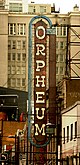
Built by the Victoria Opera House Company, the theatre served as a venue for dramatic, musical and vaudeville performances, and ultimately cinema; restored to live theatre in 1972, it is one of the finest surviving large-scale legitimate theatres in Canada Royal Theatre National Historic Site of Canada (Victoria, British Columbia).jpg
SS Moyie [81] 1898 (built)1958 Kaslo
49°54′42.12″N116°54′8.28″W / 49.9117000°N 116.9023000°W / 49.9117000; -116.9023000 (S.S. Moyie)
A late 19th-century, steam-propelled paddle steamer, dry docked since 1958 on the shore of Kootenay Lake; at retirement she was the oldest Canadian-built paddle wheeler in service Moyie (sternwheeler) at Kaslo 2008.jpg
Saint Paul's Roman Catholic Church [82] 1884 (completed), 1909 (remodelled)1980 North Vancouver
49°18′57.21″N123°5′16.97″W / 49.3158917°N 123.0880472°W / 49.3158917; -123.0880472 (Saint Paul's Roman Catholic Church)
A twin-spired, Gothic Revival church located in Eslha7an (the Mission Reserve); the oldest surviving mission church in the Vancouver area Mission Reserve opposite Vancouver, circa 1886.jpg
Similkameen Spirit Trail [83] 2007 Hedley
49°24′7.18″N120°15′29.2″W / 49.4019944°N 120.258111°W / 49.4019944; -120.258111 (Similkameen Spirit Trail)
A cultural landscape illustrating over 4000 years of Upper Similkameen history, consisting of three sites linked by an aboriginal trail route: the Tulameen Ochre Bluffs, the Chuchuwayha Rock Shelter, and a series of 27 pictograph sites Similkameen River.jpg
Skedans [84] 1986 Gwaii Haanas
52°57′52″N131°36′29″W / 52.96444°N 131.60806°W / 52.96444; -131.60806 (Skedans)
Former Haida village Skedans.jpg
St. Andrew's Roman Catholic Cathedral [85] 1892 (completed)1990 Victoria
48°25′31.5″N123°21′46.3″W / 48.425417°N 123.362861°W / 48.425417; -123.362861 (St. Andrew's Roman Catholic Cathedral)
An imposing twin-towered landmark in Victoria's urban core and an excellent representative example of the Gothic Revival style St Andrews Cathedral in Victoria.jpg
St Ann's Academy [86] 1871 (completed)1989 Victoria
48°25′8.3″N123°21′48.95″W / 48.418972°N 123.3635972°W / 48.418972; -123.3635972 (St Ann's Academy)
A monumental brick building that served for more than a century as an important educational institute in Western Canada St. Ann's Academy1.JPG
St. Roch [87] 1928 (constructed)1962 Vancouver
49°16′38.94″N123°8′49.95″W / 49.2774833°N 123.1472083°W / 49.2774833; -123.1472083 (St. Roch)
St. Roch is a restored auxiliary Royal Canadian Mounted Police schooner drydocked at the Vancouver Maritime Museum; the first ship to cross from the Pacific to the Atlantic by the Northwest Passage St roch vancouver 4.jpg
Stanley Park Beaver 1 (PSF)(retouched)(transparent).png [88] 1888 (established)1988 Vancouver
49°18′00″N123°8′24″W / 49.30000°N 123.14000°W / 49.30000; -123.14000 (Stanley Park)
404.9-hectare (1,001-acre) public park on a peninsula that formerly served as a First Nations ceremonial site and as a British military reserve; epitome of the large urban park in Canada Aerial view of Vancouver and Stanley Park, 2006-09-12.jpg
Stave Falls Hydro-Electric Installation [89] 1912 (completed)2003 Mission
49°13′44.12″N122°21′22.33″W / 49.2289222°N 122.3562028°W / 49.2289222; -122.3562028 (Stave Falls Hydro-Electric Installation)
A well-preserved example of a typical hydro-electric plant of the early 20th century, the core period of hydro-electric technological development, composed of three dams, a powerhouse, a switchyard and associated equipment BC Hydro Stave Falls-1.jpg
Tanu [90] 1735 (circa) (settlement)1986 New Clew
53°01′30″N131°46′30″W / 53.02500°N 131.77500°W / 53.02500; -131.77500 (Stave Falls Hydro-Electric Installation)
Former Haida village in Gwaii Haanas National Park Reserve Haida totem pole from Tanu.jpg
Triple Island Lighthouse [91] 1920 (completed)1974 Triple Island
54°15′48″N130°49′29″W / 54.26333°N 130.82472°W / 54.26333; -130.82472 (Triple Island Lighthouse)
An octagonal lighthouse on a rocky islet; the prevailing gales and high flood tides made its construction one of the most hazardous tasks in Canadian maritime history
Tse'K'wa [92] from 12,500 to 1,000 years agoAugust 23, 2019 Fort St. John
56°16′22″N120°56′40″W / 56.272892°N 120.944396°W / 56.272892; -120.944396 (Tse'K'wa NHS)
archeological site at a place also called Charlie Lake Cave
Twin Falls Tea House Beaver 1 (PSF)(retouched)(transparent).png [93] 1910 (completion of first phase)1992 Yoho National Park
51°32′35″N116°31′39″W / 51.54306°N 116.52750°W / 51.54306; -116.52750 (Twin Falls Tea House)
A log structure serving as a resting place for hikers; symbolic of outdoor recreation in the national parks and representative of the rustic design tradition Twin Falls Tea House Canada Yoho NP.jpg
Union Club of British Columbia [94] 1879 (established), 1913 (clubhouse)2016 Victoria
48°25′22″N123°22′02″W / 48.422870°N 123.367180°W / 48.422870; -123.367180 (Union Club of British Columbia)
An early gentlemen's club's elegant Beaux-Arts clubhouse Union Club, Victoria, British Columbia, Canada 13.jpg
Uplands [92] 1908August 23, 2019 Oak Bay
48°26′55″N123°18′18″W / 48.4485°N 123.3051°W / 48.4485; -123.3051 (Uplands NHS)
Early garden subdivision preserves Native American archeology
Vancouver Japanese Language School [65] 1928 (built)June 20, 2019 Vancouver
49°17′03″N123°05′37″W / 49.284244°N 123.093631°W / 49.284244; -123.093631
First and largest Japanese language school in the country. Significant for its return to Japanese owners after internment. Vancouver Japanese School and Hall.jpg
Vancouver's Chinatown [95] 1880 (established)2011 Vancouver
49°16′48″N123°5′58″W / 49.28000°N 123.09944°W / 49.28000; -123.09944 (Vancouver's Chinatown)
One of the oldest and largest Chinatowns in the Canada; characterized by a distinctive "recessed balcony" style of architecture Millennium Gate, Vancouver's Chinatown National Historic Site of Canada, WLM2012.jpg
Victoria City Hall [96] 1890 (completed)1977 Victoria
48°25′42″N123°21′53.46″W / 48.42833°N 123.3648500°W / 48.42833; -123.3648500 (Victoria City Hall)
One of the best surviving examples of Second Empire-style public architecture in western Canada Victoria City Hall.jpg
Victoria's Chinatown [97] 1858 (established)1995 Victoria
48°25′45.71″N123°22′4.47″W / 48.4293639°N 123.3679083°W / 48.4293639; -123.3679083 (Victoria's Chinatown)
The oldest surviving Chinatown in Canada; retains a cohesive assemblage of heritage structures and is dominated by its historical buildings Victoria - Chinese Consolidated Benevolent Association 01.jpg
Vogue Theatre [98] 1941 (completed)1993 Vancouver
49°16′47.38″N123°7′18″W / 49.2798278°N 123.12167°W / 49.2798278; -123.12167 (Vogue Theatre)
A theatre designed to accommodate both cinema and live performance; a noted and well-preserved example of the Streamline Moderne style in Canada Vogue-thtr.jpg
Weir's (Taylor's) Beach Earthworks Site [99] 1974 Metchosin
48°22′55.28″N123°32′16.66″W / 48.3820222°N 123.5379611°W / 48.3820222; -123.5379611 (Weir's (Taylor's) Beach Earthworks Site)
Pre-contact earthworks on Vancouver Island
Whaler's Shrine Site [100] 1983 Yuquot
49°35′28.63″N126°36′59.84″W / 49.5912861°N 126.6166222°W / 49.5912861; -126.6166222 (Whaler's Shrine Site)
Original site of the most significant monument associated with Nuu-chah-nulth whaling; the shrine was dismantled by an anthropologist in 1905 and presently resides at the American Museum of Natural History Wal Schrein Insel Vancouver, Kanada.jpg
Xá:ytem / Hatzic Rock [101] 3000 BCE (circa)1992 Mission
49°9′6.55″N122°15′1.56″W / 49.1518194°N 122.2504333°W / 49.1518194; -122.2504333 (Xá:ytem / Hatzic Rock)
Habitation site of Stó:lo peoples FraserRiver.jpg
Yan Village Indian Site [102] 1972 Masset
54°3′49.39″N132°14′22.25″W / 54.0637194°N 132.2395139°W / 54.0637194; -132.2395139 (Yan Village Indian Site)
Former Haida village
Yuquot [103] 1923 Yuquot
49°36′N126°37′W / 49.600°N 126.617°W / 49.600; -126.617 (Yuquot)
Centre of the social, political and economic world of the Mowachaht/Muchalaht First Nations, and the first point of contact between Europeans and an indigenous people of the west coast of Canada; location of signing of the Nootka Conventions Nootka, Yuquot Dock, Uchuck III.jpg

Former National Historic Site in BC

NameEstablishedDisbandedNotes
Kamloops Junction Railroad Station National Historic Site 1976Station demolished

See also

Related Research Articles

<span class="mw-page-title-main">Thomas Fuller (architect)</span> Canadian architect

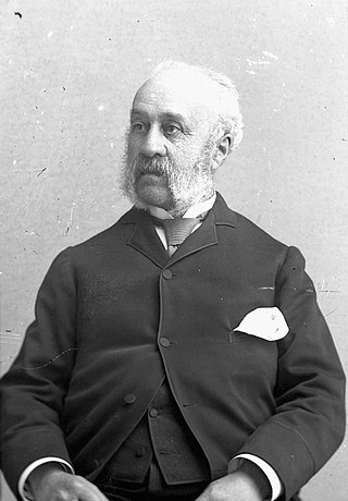
Thomas Fuller was an English-born Canadian architect. From 1881 to 1896, he was Chief Dominion Architect for the Government of Canada, during which time he played a role in the design and construction of every major federal building.

Heritage buildings in Edmonton, as elsewhere in Canada, may be designated by any of the three levels of government: the Government of Canada, the Government of Alberta, or the City of Edmonton.

<span class="mw-page-title-main">Events of National Historic Significance</span> Event designation by Canadas Minister of the Environment

The Events of National Historic Significance, also called National Historic Events, are events that have been designated by Canada's government, on the advice of the national Historic Sites and Monuments Board to the Minister of Environment and Climate Change, as being defining actions, episodes, movements or experiences in Canadian history. To be designated, an event must have occurred at least forty (40) years previous; events that continue into the more recent past are evaluated on the basis of what occurred at least 40 years ago. As of June 2023, there are 500 National Historic Events that are already recorded.

References

  1. 1 2 Directory of Federal Heritage Designations - British Columbia, Parks Canada
  2. British Columbia Archived 2012-10-06 at the Wayback Machine , National Historic Sites of Canada - administered by Parks Canada
  3. Federal plaque to John Macdonell on Ontarioplaques.com
  4. Glengarry House NHS in Directory of Federal Heritage Designations (DFHD)
  5. Landing of John Guy NHE in DFHD
  6. 223 Robert Street . Canadian Register of Historic Places . Retrieved 23 October 2011.
  7. Abbotsford Sikh Temple . Canadian Register of Historic Places . Retrieved 23 October 2011.
  8. Barkerville . Canadian Register of Historic Places . Retrieved 23 October 2011.
  9. Bay Street Drill Hall . Canadian Register of Historic Places . Retrieved 23 October 2011.
  10. Begbie Hall . Canadian Register of Historic Places . Retrieved 23 October 2011.
  11. Binning Residence . Canadian Register of Historic Places . Retrieved 23 October 2011.
  12. Boat Encampment . Canadian Register of Historic Places . Retrieved 23 October 2011.
  13. Britannia Mines Concentrator . Canadian Register of Historic Places . Retrieved 24 October 2011.
  14. Britannia Shipyard . Canadian Register of Historic Places . Retrieved 24 October 2011.
  15. Butchart Gardens . Canadian Register of Historic Places . Retrieved 24 October 2011.
  16. Chee Kung Tong Building . Canadian Register of Historic Places . Retrieved 29 October 2011.
  17. Chilkoot Trail . Canadian Register of Historic Places . Retrieved 29 October 2011.
  18. Chilliwack City Hall . Canadian Register of Historic Places . Retrieved 29 October 2011.
  19. Chinese Cemetery at Harling Point . Canadian Register of Historic Places . Retrieved 29 October 2011.
  20. Christ Church . Canadian Register of Historic Places . Retrieved 29 October 2011.
  21. Church of Our Lord . Canadian Register of Historic Places . Retrieved 30 October 2011.
  22. Church of the Holy Cross . Canadian Register of Historic Places . Retrieved 30 October 2011.
  23. Congregation Emanu-El . Canadian Register of Historic Places . Retrieved 30 October 2011.
  24. Craigdarroch Castle . Canadian Register of Historic Places . Retrieved 30 October 2011.
  25. Craigflower Manor House . Canadian Register of Historic Places . Retrieved 13 November 2011.
  26. Craigflower Schoolhouse . Canadian Register of Historic Places . Retrieved 13 November 2011.
  27. Dominion Astrophysical Observatory . Canadian Register of Historic Places . Retrieved 13 November 2011.
  28. Doukhobor Suspension Bridgey . Canadian Register of Historic Places . Retrieved 13 November 2011.
  29. Emily Carr House . Canadian Register of Historic Places . Retrieved 13 November 2011.
  30. Empress Hotel . Canadian Register of Historic Places . Retrieved 13 November 2011.
  31. Esquimalt and Nanaimo Railway Roundhouse . Canadian Register of Historic Places . Retrieved 21 November 2011.
  32. Esquimalt Naval Sites . Canadian Register of Historic Places . Retrieved 21 November 2011.
  33. Estate of the Lieutenant Governor of British Columbia . Canadian Register of Historic Places . Retrieved 23 November 2011.
  34. First Crossing of North America . Canadian Register of Historic Places . Retrieved 23 November 2011.
  35. Fisgard Lighthouse . Canadian Register of Historic Places . Retrieved 25 November 2011.
  36. Former Vancouver Law Courts . Canadian Register of Historic Places . Retrieved 25 November 2011.
  37. Former Victoria Law Courts . Canadian Register of Historic Places . Retrieved 26 November 2011.
  38. Fort Alexandria . Canadian Register of Historic Places . Retrieved 26 November 2011.
  39. "Fort Hope National Historic Site of Canada". Directory of Designations of National Historic Significance of Canada. Parks Canada . Retrieved 27 November 2011.
  40. "Fort Kamloops National Historic Site of Canada". Directory of Designations of National Historic Significance of Canada. Parks Canada . Retrieved 27 November 2011.
  41. Fort Langley . Canadian Register of Historic Places . Retrieved 27 November 2011.
  42. Fort McLeod . Canadian Register of Historic Places . Retrieved 27 November 2011.
  43. Fort Rodd Hill . Canadian Register of Historic Places . Retrieved 30 November 2011.
  44. Fort St. James . Canadian Register of Historic Places . Retrieved 8 January 2012.
  45. "Fort St. John National Historic Site of Canada". Directory of Designations of National Historic Significance of Canada. Parks Canada . Retrieved 8 January 2012.[ permanent dead link ]
  46. Fort Steele . Canadian Register of Historic Places . Retrieved 8 January 2012.
  47. Fort Victoria . Canadian Register of Historic Places . Retrieved 20 January 2012.
  48. Gastown Historic District . Canadian Register of Historic Places . Retrieved 21 January 2012.
  49. Gitwangak Battle Hill . Canadian Register of Historic Places . Retrieved 21 January 2012.
  50. Gulf of Georgia Cannery . Canadian Register of Historic Places . Retrieved 21 January 2012.
  51. Hatley Park / Former Royal Roads Military College . Canadian Register of Historic Places . Retrieved 22 January 2012.
  52. Howse Pass . Canadian Register of Historic Places . Retrieved 22 January 2012.
  53. Kaslo Municipal Hall . Canadian Register of Historic Places . Retrieved 22 January 2012.
  54. Kicking Horse Pass . Canadian Register of Historic Places . Retrieved 22 January 2012.
  55. Kiix?in Village and Fortress . Canadian Register of Historic Places . Retrieved 22 January 2012.
  56. Kitselas Canyon . Canadian Register of Historic Places . Retrieved 22 January 2012.
  57. Kitwankul National Historic Site of Canada . Directory of Federal Heritage Designations. Parks Canada . Retrieved 12 March 2013.
  58. "Kiusta Village National Historic Site of Canada". Directory of Designations of National Historic Significance of Canada. Parks Canada . Retrieved 22 January 2012.
  59. Kootenae House . Canadian Register of Historic Places . Retrieved 22 January 2012.
  60. Lions Gate Bridge . Canadian Register of Historic Places . Retrieved 22 January 2012.
  61. Malahat Building / Old Victoria Custom House . Canadian Register of Historic Places . Retrieved 24 January 2012.
  62. Marpole Midden . Canadian Register of Historic Places . Retrieved 24 January 2012.
  63. McLean Mill . Canadian Register of Historic Places . Retrieved 24 January 2012.
  64. Metlakatla Pass . Canadian Register of Historic Places . Retrieved 28 January 2012.
  65. 1 2 Canada Announces New National Historic Designations, Parks Canada news release, June 20, 2019
  66. Metlakatla Pass . Canadian Register of Historic Places . Retrieved 28 January 2012.
  67. Myra Canyon Section of the Kettle Valley Railway . Canadian Register of Historic Places . Retrieved 28 January 2012.
  68. "Nan Sdins National Historic Site of Canada". Directory of Designations of National Historic Significance of Canada. Parks Canada . Retrieved 28 January 2012.[ permanent dead link ]
  69. "New Gold Harbour Area National Historic Site of Canada". Directory of Designations of National Historic Significance of Canada. Parks Canada . Retrieved 21 January 2012.
  70. Nikkei Internment Memorial Centre . Canadian Register of Historic Places . Retrieved 28 January 2012.
  71. North Pacific Cannery . Canadian Register of Historic Places . Retrieved 28 January 2012.
  72. Orpheum Theatre . Canadian Register of Historic Places . Retrieved 28 January 2012.
  73. Pemberton Memorial Operating Room . Canadian Register of Historic Places . Retrieved 28 January 2012.
  74. Point Atkinson Lighthouse . Canadian Register of Historic Places . Retrieved 28 January 2012.
  75. Point Ellice House / O'Reilly House . Canadian Register of Historic Places . Retrieved 28 January 2012.
  76. Powell River Townsite Historic District . Canadian Register of Historic Places . Retrieved 28 January 2012.
  77. Rogers Building . Canadian Register of Historic Places . Retrieved 28 January 2012.
  78. Rogers Pass . Canadian Register of Historic Places . Retrieved 28 January 2012.
  79. Rossland Court House . Canadian Register of Historic Places . Retrieved 29 January 2012.
  80. Royal Theatre . Canadian Register of Historic Places . Retrieved 29 January 2012.
  81. S.S. Moyie . Canadian Register of Historic Places . Retrieved 29 January 2012.
  82. Saint Paul's Roman Catholic Church . Canadian Register of Historic Places . Retrieved 29 January 2012.
  83. Similkameen Spirit Trail . Canadian Register of Historic Places . Retrieved 29 January 2012.
  84. "Skedans National Historic Site of Canada". Directory of Designations of National Historic Significance of Canada. Parks Canada . Retrieved 29 January 2012.[ permanent dead link ]
  85. St. Andrew's Roman Catholic Cathedral . Canadian Register of Historic Places . Retrieved 29 January 2012.
  86. St Ann's Academy . Canadian Register of Historic Places . Retrieved 30 January 2012.
  87. St. Roch . Canadian Register of Historic Places . Retrieved 30 January 2012.
  88. Stanley Park . Canadian Register of Historic Places . Retrieved 31 January 2012.
  89. Stave Falls Hydro-Electric Installation . Canadian Register of Historic Places . Retrieved 1 February 2012.
  90. "Tanu National Historic Site of Canada". Directory of Designations of National Historic Significance of Canada. Parks Canada . Retrieved 1 February 2012.[ permanent dead link ]
  91. Triple Island Lighthouse . Canadian Register of Historic Places . Retrieved 2 February 2012.
  92. 1 2 Government of Canada Announces Seven National Historic Designations, Parks Canada news release, August 23, 2019
  93. Twin Falls Tea House . Canadian Register of Historic Places . Retrieved 2 February 2012.
  94. The Union Club of British Columbia, Parks Canada backgrounder, July 4, 2016
  95. Vancouver's Chinatown . Directory of Federal Heritage Designations. Parks Canada . Retrieved 4 May 2012.
  96. Victoria City Hall . Canadian Register of Historic Places . Retrieved 4 February 2012.
  97. Victoria's Chinatown . Canadian Register of Historic Places . Retrieved 4 February 2012.
  98. Vogue Theatre . Canadian Register of Historic Places . Retrieved 4 February 2012.
  99. "Weir's (Taylor's) Beach Earthworks Site National Historic Site of Canada". Directory of Designations of National Historic Significance of Canada. Parks Canada . Retrieved 5 February 2012.
  100. Whaler's Shrine Site . Canadian Register of Historic Places . Retrieved 5 February 2012.
  101. Xá:ytem / Hatzic Rock . Canadian Register of Historic Places . Retrieved 5 February 2012.
  102. "Yan Village Indian Site National Historic Site of Canada". Directory of Designations of National Historic Significance of Canada. Parks Canada . Retrieved 5 February 2012.
  103. Yuquot . Canadian Register of Historic Places . Retrieved 5 February 2012.