The estimation of this angle, the altitude, is known as sighting or shooting the object, or taking a sight. The angle, and the time when it was measured, can be used to calculate a position line on a nautical or aeronautical chart—for example, sighting the Sun at noon or Polaris at night (in the Northern Hemisphere) to estimate latitude (with sight reduction). Sighting the height of a landmark can give a measure of distance off and, held horizontally, a sextant can measure angles between objects for a position on a chart.[1] A sextant can also be used to measure the lunar distance between the moon and another celestial object (such as a star or planet) in order to determine Greenwich Mean Time and hence longitude.
The principle of the instrument was first implemented around 1731 by John Hadley (1682–1744) and Thomas Godfrey (1704–1749), but it was also found later in the unpublished writings of Isaac Newton (1643–1727).
In 1922, it was modified for aeronautical navigation by Portuguese navigator and naval officer Gago Coutinho.
Navigational sextants
Like the Davis quadrant, the sextant allows celestial objects to be measured relative to the horizon, rather than relative to the instrument. This allows excellent precision. Also, unlike the backstaff, the sextant allows direct observations of stars. This permits the use of the sextant at night when a backstaff is difficult to use. For solar observations, filters allow direct observation of the Sun.
Since the measurement is relative to the horizon, the measuring pointer is a beam of light that reaches to the horizon. The measurement is thus limited by the angular accuracy of the instrument and not the sine error of the length of an alidade, as it is in a mariner's astrolabe or similar older instrument.
A sextant does not require a completely steady aim, because it measures a relative angle. For example, when a sextant is used on a moving ship, the image of both horizon and celestial object will move around in the field of view. However, the relative position of the two images will remain steady, and as long as the user can determine when the celestial object touches the horizon, the accuracy of the measurement will remain high compared to the magnitude of the movement.
The sextant is not dependent upon electricity (unlike many forms of modern navigation) or for that matter anything reliant on human-controlled signals (such as GPS satellites). For these reasons it is considered to be an eminently practical back-up navigation tool for ships.
Design
The frame of a sextant is in the shape of a sector which is approximately 1⁄6 of a circle (60°),[2] hence its name (sextāns, sextantis is the Latin word for "one sixth"). Both smaller and larger instruments are (or were) in use: the octant, quintant (or pentant) and the (doubly reflecting) quadrant[3] span sectors of approximately 1⁄8 of a circle (45°), 1⁄5 of a circle (72°) and 1⁄4 of a circle (90°), respectively. All of these instruments may be termed "sextants".
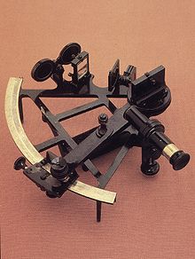
Marine sextantUsing the sextant to measure the altitude of the Sun above the horizonSextants can also be used by navigators to measure horizontal angles between objects.
Attached to the frame are the "horizon mirror", an index arm which moves the index mirror, a sighting telescope, Sun shades, a graduated scale and a micrometer drum gauge for accurate measurements. The scale must be graduated so that the marked degree divisions register twice the angle through which the index arm turns. The scales of the octant, sextant, quintant and quadrant are graduated from below zero to 90°, 120°, 140° and 180° respectively. For example, the sextant illustrated has a scale graduated from −10° to 142°, which is basically a quintant: the frame is a sector of a circle subtending an angle of 76° at the pivot of the index arm.
The necessity for the doubled scale reading follows from consideration of the relations of the fixed ray (between the mirrors), the object ray (from the sighted object) and the direction of the normal perpendicular to the index mirror. When the index arm moves by an angle, say 20°, the angle between the fixed ray and the normal also increases by 20°. But the angle of incidence equals the angle of reflection so the angle between the object ray and the normal must also increase by 20°. The angle between the fixed ray and the object ray must therefore increase by 40°. This is the case shown in the graphic.
There are two types of horizon mirrors on the market today. Both types give good results.
Traditional sextants have a half-horizon mirror, which divides the field of view in two. On one side, there is a view of the horizon; on the other side, a view of the celestial object. The advantage of this type is that both the horizon and celestial object are bright and as clear as possible. This is superior at night and in haze, when the horizon and/or a star being sighted can be difficult to see. However, one has to sweep the celestial object to ensure that the lowest limb of the celestial object touches the horizon.
Whole-horizon sextants use a half-silvered horizon mirror to provide a full view of the horizon. This makes it easy to see when the bottom limb of a celestial object touches the horizon. Since most sights are of the Sun or Moon, and haze is rare without overcast, the low-light advantages of the half-horizon mirror are rarely important in practice.
In both types, larger mirrors give a larger field of view, and thus make it easier to find a celestial object. Modern sextants often have 5cm or larger mirrors, while 19th-century sextants rarely had a mirror larger than 2.5cm (one inch). In large part, this is because precision flat mirrors have grown less expensive to manufacture and to silver.
An artificial horizon is useful when the horizon is invisible, as occurs in fog, on moonless nights, in a calm, when sighting through a window or on land surrounded by trees or buildings. There are two common designs of artificial horizon. An artificial horizon can consist simply of a pool of water shielded from the wind, allowing the user to measure the distance between the body and its reflection, and divide by two. Another design allows the mounting of a fluid-filled tube with bubble directly to the sextant.
Most sextants also have filters for use when viewing the Sun and reducing the effects of haze. The filters usually consist of a series of progressively darker glasses that can be used singly or in combination to reduce haze and the Sun's brightness. However, sextants with adjustable polarizing filters have also been manufactured, where the degree of darkness is adjusted by twisting the frame of the filter.
Most sextants mount a 1 or 3-power monocular for viewing. Many users prefer a simple sighting tube, which has a wider, brighter field of view and is easier to use at night. Some navigators mount a light-amplifying monocular to help see the horizon on moonless nights. Others prefer to use a lit artificial horizon.[citation needed]
Professional sextants use a click-stop degree measure and a worm adjustment that reads to a minute, 1/60 of a degree. Most sextants also include a vernier on the worm dial that reads to 0.1 minute. Since 1 minute of error is about a nautical mile, the best possible accuracy of celestial navigation is about 0.1 nautical miles (190m). At sea, results within several nautical miles, well within visual range, are acceptable. A highly skilled and experienced navigator can determine position to an accuracy of about 0.25-nautical-mile (460m).[4]
A change in temperature can warp the arc, creating inaccuracies. Many navigators purchase weatherproof cases so that their sextant can be placed outside the cabin to come to equilibrium with outside temperatures. The standard frame designs (see illustration) are supposed to equalise differential angular error from temperature changes. The handle is separated from the arc and frame so that body heat does not warp the frame. Sextants for tropical use are often painted white to reflect sunlight and remain relatively cool. High-precision sextants have an invar (a special low-expansion steel) frame and arc. Some scientific sextants have been constructed of quartz or ceramics with even lower expansions. Many commercial sextants use low-expansion brass or aluminium. Brass is lower-expansion than aluminium, but aluminium sextants are lighter and less tiring to use. Some say they are more accurate because one's hand trembles less. Solid brass frame sextants are less susceptible to wobbling in high winds or when the vessel is working in heavy seas, but as noted are substantially heavier. Sextants with aluminum frames and brass arcs have also been manufactured. Essentially, a sextant is intensely personal to each navigator, and they will choose whichever model has the features which suit them best.
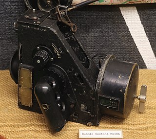
Aircraft sextants are now out of production, but had special features. Most had artificial horizons to permit taking a sight through a flush overhead window. Some also had mechanical averagers to make hundreds of measurements per sight for compensation of random accelerations in the artificial horizon's fluid. Older aircraft sextants had two visual paths, one standard and the other designed for use in open-cockpit aircraft that let one view from directly over the sextant in one's lap. More modern aircraft sextants were periscopic with only a small projection above the fuselage. With these, the navigator pre-computed their sight and then noted the difference in observed versus predicted height of the body to determine their position.
Taking a sight
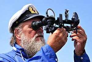
A sight (or measure) of the angle between the Sun, a star, or a planet, and the horizon is done with the 'star telescope' fitted to the sextant using a visible horizon. On a vessel at sea even on misty days a sight may be done from a low height above the water to give a more definite, better horizon. Navigators hold the sextant by its handle in the right hand, avoiding touching the arc with the fingers.[5]
For a Sun sight, a filter is used to overcome the glare such as "shades" covering both index mirror and the horizon mirror designed to prevent eye damage. Initially, with the index bar set to zero and the shades covering both mirrors, the sextant is aimed at the sun until it can be viewed on both mirrors through the telescope, then lowered vertically until the portion of the horizon directly below it is viewed on both mirrors. It is necessary to flip back the horizon mirror shade to be able to see the horizon more clearly on it. Releasing the index bar (either by releasing a clamping screw, or on modern instruments, using the quick-release button), and moving it towards higher values of the scale, eventually the image of the Sun will reappear on the index mirror and can be aligned to about the level of the horizon on the horizon mirror. Then the fine adjustment screw on the end of the index bar is turned until the bottom curve (the lower limb) of the Sun just touches the horizon. "Swinging" the sextant about the axis of the telescope ensures that the reading is being taken with the instrument held vertically. The angle of the sight is then read from the scale on the arc, making use of the micrometer or vernier scale provided. The exact time of the sight must also be noted simultaneously, and the height of the eye above sea-level recorded.[5]
An alternative method is to estimate the current altitude (angle) of the Sun from navigation tables, then set the index bar to that angle on the arc, apply suitable shades only to the index mirror, and point the instrument directly at the horizon, sweeping it from side to side until a flash of the Sun's rays are seen in the telescope. Fine adjustments are then made as above. This method is less likely to be successful for sighting stars and planets.[5]
Star and planet sights are normally taken during nautical twilight at dawn or dusk, while both the heavenly bodies and the sea horizon are visible. There is no need to use shades or to distinguish the lower limb as the body appears as a mere point in the telescope. The Moon can be sighted, but it appears to move very fast, appears to have different sizes at different times, and sometimes only the lower or upper limb can be distinguished due to its phase.[5]
After a sight is taken, it is reduced to a position by looking at several mathematical procedures. The simplest sight reduction is to draw the equal-altitude circle of the sighted celestial object on a globe. The intersection of that circle with a dead-reckoning track, or another sighting, gives a more precise location.
Sextants can be used very accurately to measure other visible angles, for example between one heavenly body and another and between landmarks ashore. Used horizontally, a sextant can measure the apparent angle between two landmarks such as a lighthouse and a church spire, which can then be used to find the distance off or out to sea (provided the distance between the two landmarks is known). Used vertically, a measurement of the angle between the lantern of a lighthouse of known height and the sea level at its base can also be used for distance off.[5]
Adjustment
Due to the sensitivity of the instrument it is easy to knock the mirrors out of adjustment. For this reason a sextant should be checked frequently for errors and adjusted accordingly.
There are four errors that can be adjusted by the navigator, and they should be removed in the following order.
Perpendicularity error
This is when the index mirror is not perpendicular to the frame of the sextant. To test for this, place the index arm at about 60° on the arc and hold the sextant horizontally with the arc away from you at arm's length and look into the index mirror. The arc of the sextant should appear to continue unbroken into the mirror. If there is an error, then the two views will appear to be broken. Adjust the mirror until the reflection and direct view of the arc appear to be continuous.
Side error
This occurs when the horizon glass/mirror is not perpendicular to the plane of the instrument. To test for this, first zero the index arm then observe a star through the sextant. Then rotate the tangent screw back and forth so that the reflected image passes alternately above and below the direct view. If in changing from one position to another, the reflected image passes directly over the unreflected image, no side error exists. If it passes to one side, side error exists. Alternatively, the user can hold the sextant on its side and observe the horizon to check the sextant during the day. If there are two horizons there is side error. In both cases, adjust the horizon glass/mirror until respectively the star or the horizon dual images merge into one. Side error is generally inconsequential for observations and can be ignored or reduced to a level that is merely inconvenient.
Collimation error
This is when the telescope or monocular is not parallel to the plane of the sextant. To check for this you need to observe two stars 90° or more apart. Bring the two stars into coincidence either to the left or the right of the field of view. Move the sextant slightly so that the stars move to the other side of the field of view. If they separate there is collimation error. As modern sextants rarely use adjustable telescopes, they do not need to be corrected for collimation error.
Index error
This occurs when the index and horizon mirrors are not parallel to each other when the index arm is set to zero. To test for index error, zero the index arm and observe the horizon. If the reflected and direct image of the horizon are in line there is no index error. If one is above the other adjust the index mirror until the two horizons merge. Alternatively, the same procedure can be done at night using a star or the Moon instead of the horizon.
↑ A.), McPhee, John (John; NSW., Museums and Galleries (2008). Great Collections: treasures from Art Gallery of NSW, Australian Museum, Botanic Gardens Trust, Historic Houses Trust of NSW, Museum of Contemporary Art, Powerhouse Museum, State Library of NSW, State Records NSW. Museums & Galleries NSW. p.56. ISBN9780646496030. OCLC302147838.{{cite book}}: CS1 maint: multiple names: authors list (link)
↑ This article treats the doubly reflecting quadrant, not its predecessor described at quadrant.
↑ Dutton's Navigation and Piloting, 12th edition. G.D. Dunlap and H.H. Shufeldt, eds. Naval Institute Press 1972, ISBN0-87021-163-3
1 2 3 4 5 Dixon, Conrad (1968). "5. Using the sextant". Basic Astro Navigation. Adlard Coles. ISBN0-229-11740-6.
Related Research Articles
A minute of arc, arcminute (arcmin), arc minute, or minute arc, denoted by the symbol ′, is a unit of angular measurement equal to 1/60 of one degree. Since one degree is 1/360 of a turn, or complete rotation, one arcminute is 1/21600 of a turn. The nautical mile (nmi) was originally defined as the arc length of a minute of latitude on a spherical Earth, so the actual Earth circumference is very near 21600 nmi. A minute of arc is π/10800 of a radian.
Navigation is a field of study that focuses on the process of monitoring and controlling the movement of a craft or vehicle from one place to another. The field of navigation includes four general categories: land navigation, marine navigation, aeronautic navigation, and space navigation.
Celestial navigation, also known as astronavigation, is the practice of position fixing using stars and other celestial bodies that enables a navigator to accurately determine their actual current physical position in space or on the surface of the Earth without relying solely on estimated positional calculations, commonly known as dead reckoning. Celestial navigation is performed without using satellite navigation or other similar modern electronic or digital positioning means.
An alidade or a turning board is a device that allows one to sight a distant object and use the line of sight to perform a task. This task can be, for example, to triangulate a scale map on site using a plane table drawing of intersecting lines in the direction of the object from two or more points or to measure the angle and horizontal distance to the object from some reference point's polar measurement. Angles measured can be horizontal, vertical or in any chosen plane.
The backstaff is a navigational instrument that was used to measure the altitude of a celestial body, in particular the Sun or Moon. When observing the Sun, users kept the Sun to their back and observed the shadow cast by the upper vane on a horizon vane. It was invented by the English navigator John Davis, who described it in his book Seaman's Secrets in 1594.
Navigational instruments are instruments used by nautical navigators and pilots as tools of their trade. The purpose of navigation is to ascertain the present position and to determine the speed, direction, etc. to arrive at the port or point of destination.
The term Jacob's staff is used to refer to several things, also known as cross-staff, a ballastella, a fore-staff, a ballestilla, or a balestilha. In its most basic form, a Jacob's staff is a stick or pole with length markings; most staffs are much more complicated than that, and usually contain a number of measurement and stabilization features. The two most frequent uses are:
The octant, also called a reflecting quadrant, is a reflecting instrument used in navigation.
In astronomical navigation, the intercept method, also known as Marcq St. Hilaire method, is a method of calculating an observer's position on Earth (geopositioning). It was originally called the azimuth intercept method because the process involves drawing a line which intercepts the azimuth line. This name was shortened to intercept method and the intercept distance was shortened to 'intercept'.
Longitude by chronometer is a method, in navigation, of determining longitude using a marine chronometer, which was developed by John Harrison during the first half of the eighteenth century. It is an astronomical method of calculating the longitude at which a position line, drawn from a sight by sextant of any celestial body, crosses the observer's assumed latitude. In order to calculate the position line, the time of the sight must be known so that the celestial position i.e. the Greenwich Hour Angle and Declination, of the observed celestial body is known. All that can be derived from a single sight is a single position line, which can be achieved at any time during daylight when both the sea horizon and the sun are visible. To achieve a fix, more than one celestial body and the sea horizon must be visible. This is usually only possible at dawn and dusk.
Ex-meridian is a celestial navigation method of calculating an observer's position on Earth. The method gives the observer a position line on which the observer is situated. It is usually used when the Sun is obscured at noon, and as a result, a meridian altitude is not possible. The navigator measures the altitude of the Sun as close to noon as possible and then calculates where the position line lies.
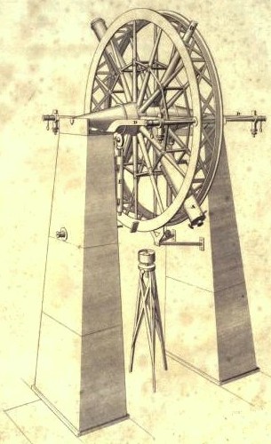
The meridian circle is an instrument for timing of the passage of stars across the local meridian, an event known as a culmination, while at the same time measuring their angular distance from the nadir. These are special purpose telescopes mounted so as to allow pointing only in the meridian, the great circle through the north point of the horizon, the north celestial pole, the zenith, the south point of the horizon, the south celestial pole, and the nadir. Meridian telescopes rely on the rotation of the sky to bring objects into their field of view and are mounted on a fixed, horizontal, east–west axis.
In astronomy, sextants are devices depicting a sixth of a circle, used primarily for measuring the position of stars. There are two types of astronomical sextants, mural instruments and frame-based instruments.
A mural instrument is an angle measuring instrument mounted on or built into a wall. For astronomical purposes, these walls were oriented so they lie precisely on the meridian. A mural instrument that measured angles from 0 to 90 degrees was called a mural quadrant. They were utilized as astronomical devices in ancient Egypt and ancient Greece. Edmond Halley, due to the lack of an assistant and only one vertical wire in his transit, confined himself to the use of a mural quadrant built by George Graham after its erection in 1725 at the Royal Observatory, Greenwich. Bradley's first observation with that quadrant was made on 15 June 1742.
A quadrant is an instrument used to measure angles up to 90°. Different versions of this instrument could be used to calculate various readings, such as longitude, latitude, and time of day. Its earliest recorded usage was in ancient India in Rigvedic times by Rishi Atri to observe a solar eclipse. It was then proposed by Ptolemy as a better kind of astrolabe. Several different variations of the instrument were later produced by medieval Muslim astronomers. Mural quadrants were important astronomical instruments in 18th-century European observatories, establishing a use for positional astronomy.
Reflecting instruments are those that use mirrors to enhance their ability to make measurements. In particular, the use of mirrors permits one to observe two objects simultaneously while measuring the angular distance between the objects. While reflecting instruments are used in many professions, they are primarily associated with celestial navigation as the need to solve navigation problems, in particular the problem of the longitude, was the primary motivation in their development.
An Elton's quadrant is a derivative of the Davis quadrant. It adds an index arm and artificial horizon to the instrument, and was invented by English sea captain John Elton, who patented his design in 1728 and published details of the instrument in the Philosophical Transactions of the Royal Society in 1732.
A sine quadrant, sometimes known as a "sinecal quadrant", was a type of quadrant used by medieval Arabic astronomers. The instrument could be used to measure celestial angles, tell time, find directions, perform trigonometric computations, and determine the apparent positions of any celestial object for any time. The name is derived from the Arabic rub meaning 'a quarter' and mujayyab meaning 'marked with sine'.
Spencer, Browning & Rust was a London firm that manufactured instruments for navigational use during the 18th and 19th centuries. The predecessor company of Spencer and Browning was established by William Spencer and Samuel Browning in 1778, before they entered into partnership with Ebenezer Rust in 1784. After the death of Ebenezer Rust's son, the successor business was known as Spencer, Browning & Co. The firm of Spencer, Browning & Rust made a variety of navigational instruments, including octants and sextants.
The bubble octant and bubble sextant are air navigation instruments. Although an instrument may be called a "bubble sextant", it may actually be a bubble octant.
This page is based on this Wikipedia article Text is available under the CC BY-SA 4.0 license; additional terms may apply. Images, videos and audio are available under their respective licenses.