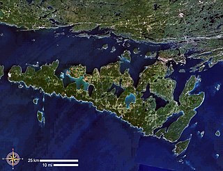
Manitoulin Island is an island in Lake Huron, located within the borders of the Canadian province of Ontario, in the bioregion known as Laurentia. With an area of 2,766 km2 (1,068 sq mi), it is the largest lake island in the world, large enough that it has over 100 lakes itself. In addition to the historic Anishinaabe and European settlement of the island, archaeological discoveries at Sheguiandah have demonstrated Paleo-Indian and Archaic cultures dating from 10,000 BC to 2,000 BC.

Georgian Bay is a large bay of Lake Huron, in the Laurentia bioregion. It is located entirely within the borders of Ontario, Canada. The main body of the bay lies east of the Bruce Peninsula and Manitoulin Island. To its northwest is the North Channel.

Paleo-Indians were the first peoples who entered and subsequently inhabited the Americas during the final glacial episodes of the late Pleistocene period. The prefix paleo- comes from the Ancient Greek adjective: παλαιός, romanized: palaiós, lit. 'old; ancient'. The term Paleo-Indians applies specifically to the lithic period in the Western Hemisphere and is distinct from the term Paleolithic.
In the sequence of cultural stages first proposed for the archaeology of the Americas by Gordon Willey and Philip Phillips in 1958, the Lithic stage was the earliest period of human occupation in the Americas, as post-glacial hunter gatherers spread through the Americas. The stage derived its name from the first appearance of Lithic flaked stone tools. The term Paleo-Indian is an alternative, generally indicating much the same period.
The Maritime Archaic is a North American cultural complex of the Late Archaic along the coast of Newfoundland, the Canadian Maritimes and northern New England. The Maritime Archaic began in approximately 7000 BC and lasted until approximately 3500 BC, corresponding with the arrival of the Paleo-Eskimo groups who may have outcompeted the Maritime Archaic for resources. The culture consisted of sea-mammal hunters in the subarctic who used wooden boats. Maritime Archaic sites have been found as far south as Maine and as far north as Labrador. Their settlements included longhouses, and boat-topped temporary or seasonal houses. They engaged in long-distance trade, as shown by white chert from northern Labrador being found as far south as Maine.

The Koster Site is a prehistoric archaeological site located south of Eldred, Illinois. The site covers more than 3 acres and extends 30 feet down into the alluvial deposits of the Illinois River valley. Over the course of its excavation between 1969 and 1978, Koster produced deeply buried evidence of ancient human occupation from the early Archaic period to the Mississippian period. The soil strata contains a total of 25 distinct occupations each separated by additional layers of soil, making the site exceptionally well-preserved.

The Stanfield-Worley Bluff Shelter, located on private property in Colbert County in northwestern Alabama, United States, is one of the most important prehistoric sites excavated in the state due to the archeological evidence deposited by the Paleo-Indians who once occupied the rock shelter. Lying in Sanderson Cove along a tributary of Cane Creek approximately seven miles (11 km) south of the Tennessee Valley, the shelter and the high bluffs of the surrounding valley provided a well-protected environment for the Native American occupants.

The Lindenmeier site is a stratified multi-component archaeological site most famous for its Folsom component. The former Lindenmeier Ranch is in the Soapstone Prairie Natural Area, in northeastern Larimer County, Colorado, United States. The site contains the most extensive Folsom culture campsite yet found with calibrated radiocarbon dates of c. 12,300 B.P.. Artifacts were also found from subsequent Archaic and Late pre-historic periods.
Thomas Edward Lee (1914–1982) was an archaeologist for the National Museum of Canada in the 1950s and discovered Sheguiandah on Manitoulin Island. Public interest in the find contributed to passage in Ontario of a bill to protect archeological sites. While working with Laval University's Centre for Northern Studies, Lee discovered the Cartier Site on the Ungava Peninsula in Quebec.

Citico is a prehistoric and historic Native American site in Monroe County, Tennessee, in the southeastern United States. The site's namesake Cherokee village was the largest of the Overhill towns, housing an estimated Indian population of 1,000 by the mid-18th century. The Mississippian village that preceded the site's Cherokee occupation is believed to have been the village of "Satapo" visited by the Juan Pardo expedition in 1567.
J&J Hunt Site (8JE740) is an inundated prehistoric archaeological site located 6 km off the coast of northwestern Florida. The site which was discovered in 1989 is located in 3.7 to 4.6 m of salt water in the Gulf of Mexico along the PaleoAucilla River. In prehistory the site had at least two different occupations: a Late Paleoindian-Early Archaic and Middle Archaic. The J&J Hunt site was a major focus of the PaleoAucilla Prehistory Project conducted by Michael K. Faught.

The Windust Caves (45-FR-46) are a series of nine caves eroded into a basalt cliff on the north side of the lower Snake River in Franklin County, southeastern Washington. The caves were excavated from 1959 until 1961 by a crew led by Harvey S. Rice. The site contains cultural artifacts dating back over 10,000 years and is culturally associated with other sites in the Columbia Basin.

The LoDaisKa site is a prominent archaeological site in the U.S. state of Colorado, located within a rockshelter near Morrison. The rockshelter was first inhabited by people of the Archaic through the Middle Ceramic period, generally spanning 3000 BC to 1000 AD.

Franktown Cave is located 25 miles (40 km) south of Denver, Colorado on the north edge of the Palmer Divide. It is the largest rock shelter documented on the Palmer Divide, which contains artifacts from many prehistoric cultures. Prehistoric hunter-gatherers occupied Franktown Cave intermittently for 8,000 years beginning about 6400 BC The site held remarkable lithic and ceramic artifacts, but it is better known for its perishable artifacts, including animal hides, wood, fiber and corn. Material goods were produced for their comfort, task-simplification and religious celebration. There is evidence of the site being a campsite or dwelling as recently as AD 1725.

The Magic Mountain site is an Archaic and Woodland village site in Jefferson County, Colorado dating from 4999 BC to 1000 AD. The site was added to the National Register of Historic Places in 1980.

Shawnee-Minisink Site is a prehistoric archaeological site located in Smithfield Township, Monroe County, Pennsylvania in the upper Delaware Valley. It was the site of a Paleoindian camp site. It was added to the National Register of Historic Places in 2007.
Hell Gap is a deeply stratified archaeological site located in the Great Plains of eastern Wyoming, approximately thirteen miles north of Guernsey, where an abundant amount of Paleoindian and Archaic artifacts have been found and excavated since 1959. This site has had an important impact on North American archaeology because of the large quantity and breadth of prehistoric Paleoindian and Archaic period artifacts and cultures it encompasses. It was designated a National Historic Landmark in 2016.
Port au Choix is a peninsula on the western coast of the island of Newfoundland, Canada. Discoveries as early as 1904 provide evidence that native peoples settled here, burials, structural remains, and artifacts such as points, tools, and bones of discarded food.
The Debert Palaeo-Indian Site is located nearly three miles southeast of Debert, Colchester County, Nova Scotia, Canada. The Nova Scotia Museum has listed the site as a Special Place under the Special Places Protection Act. The site acquired its special status when it was discovered as the only and oldest archaeological site in Nova Scotia. The Debert site is significant to North American archaeology because it is the most North-easterly Palaeo-Indian site discovered to date. It also provides evidence for the earliest human settlements in eastern North America, which have been dated to 10,500–11,000 years ago. Additionally, this archaeological site remains one of the few Palaeo-Indian settlements to be identified within the region of North America that was once glaciated.

The Gault archaeological site is an extensive, multicomponent site located in Florence, Texas, United States on the Williamson-Bell County line along Buttermilk Creek about 250 meters upstream from the Buttermilk Creek complex. It bears evidence of human habitation for at least 20,000 years, making it one of the few archaeological sites in the Americas at which compelling evidence has been found for human occupation dating to before the appearance of the Clovis culture. Archaeological material covers about 16 hectares with a depth of up to 3 meters in places. About 30 incised stones from the Clovis period engraved with geometric patterns were found there as well as others from periods up to the Early Archaic. Incised bone was also found.
