
Tanna is an island in Tafea Province of Vanuatu.
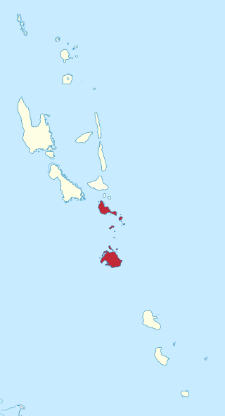
Shefa is one of the six provinces of Vanuatu, located in the center of the country and including the islands of Epi and Efate and the Shepherd Islands. The province's name is derived from the initial letters of SHepherd and EFAte. It has a population of 78,723 people and an area of 1,455 km2. Its capital is Port Vila, which is also the capital of the nation.
The Central Vanuatu languages form a linkage of Southern Oceanic languages spoken in central Vanuatu.

Emae is an island in the Shepherd Islands, Shefa, Vanuatu.
The Namakura language, Makura or Namakir, is an Oceanic language of Vanuatu. The language is spoken in Shefa Province, north Efate, Tongoa, and Tongariki. It is the only North-Central Vanuatu language to have preserved the Proto-Oceanic *q, reflected as a glottal stop.

North Efate, also known as Nakanamanga or Nguna, is an Oceanic language spoken on the northern area of Efate in Vanuatu, as well as on a number of islands off the northern coast – including Nguna, and parts of Tongoa, Emae and Epi.
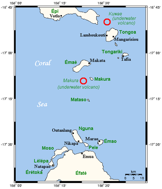
Kuwae was a landmass that existed in the vicinity of Tongoa and was destroyed by volcanic eruption in fifteenth century, probably through caldera subsidence. The exact location of the caldera is debated. A submarine caldera, now known as Kuwae caldera that is located between the Epi and Tongoa islands is a potential candidate. Kuwae Caldera cuts through the flank of the Tavani Ruru volcano on Epi and the northwestern end of Tongoa. Another potential candidate is a proposed caldera between Tongoa and Tongariki.
Emae, or Fakamae, is a Polynesian outlier language of Vanuatu.

Pélé Island, sometimes spelled Pele in English, is a volcanic island located 11,2 miles north of the island of Éfaté in the Shefa Province of the Republic of Vanuatu. It has a total area of 1.7 square miles, Pélé is inhabited by about 200-220 Ni-Vanuatu villagers residing in the four villages: Worsiviu, Worearu, Piliura, and Launamoa. Pélé Island is a part of the MPA Nguna-Pele Marine Protected Area, which was established in 2003, and is a popular Vanuatuan diving location. The Nguna-Pele Marine Protected Area covers a total area of 11.5 sq. mi., including numerous reefs, sea grass beds, mangrove forests and intertidal lagoons. The Nguna-Pele Marine Protection Agency is located in the village of Piliura, and mounts an exhibition and sells T-shirts. Income from tourism is distributed by the Village Tourism Committee and supports aims as village water supply projects. The island can be visited daily by boat from the Paonangisu area by the town of Emua on Éfaté's north coast. There are also yachts available both from Emua and Nguna for day and overnight charters to the island. The island is nearly adjacent to the island of Nguna, with a small passage no deeper than 33 yards separating the two. It has a tropical climate and has a maximum elevation of 650 feet at its highest. Much of the island is extremely steep and rocks prevent you from walking along the coastline around the island. White sandy beaches are found in Piliura, Worearu, Laonamoa, and Sake. Overpopulation has led to a steady migration from Pele villages to southern Nguna in recent times.

Mataso is an island in the Shefa of Vanuatu in the Pacific Ocean. The island is a part of Shepherd Islands archipelago.

Ifira is an offshore island of Efate, located in Shefa Province of Vanuatu in the Pacific Ocean.

Makura, locally known as Makira, is a small inhabited island in Shefa Province of Vanuatu in the Pacific Ocean. Makura is a part of the Shepherds Islands archipelago.
Tongoa Island is an inhabited island in Shefa Province of Vanuatu in the Pacific Ocean.
Buninga Island is an inhabited island in Shefa Province of Vanuatu in the Pacific Ocean. The island is a part of Shepherd Islands archipelago.
Tongariki Island is an inhabited island in Shefa Province of Vanuatu in the Pacific Ocean. The island is a part of Shepherd Islands archipelago.
Falea is a small uninhabited island in the Pacific Ocean, a part of the Shepherd Islands archipelago in the Shefa Province of Vanuatu.
Laika is a small uninhabited island in the Pacific Ocean, a part of the Shepherd Islands archipelago in the Shefa Province of Vanuatu.

Tefala is a small uninhabited island in the Pacific Ocean, belonging to the Shefa Province of Vanuatu.
Fatumiala is a small island in the Pacific Ocean, a part of the Shefa Province of Vanuatu.

