
James Hutton was a Scottish geologist, agriculturalist, chemical manufacturer, naturalist and physician. Often referred to as the "Father of Modern Geology," he played a key role in establishing geology as a modern science.

Uniformitarianism, also known as the Doctrine of Uniformity or the Uniformitarian Principle, is the assumption that the same natural laws and processes that operate in our present-day scientific observations have always operated in the universe in the past and apply everywhere in the universe. It refers to invariance in the metaphysical principles underpinning science, such as the constancy of cause and effect throughout space-time, but has also been used to describe spatiotemporal invariance of physical laws. Though an unprovable postulate that cannot be verified using the scientific method, some consider that uniformitarianism should be a required first principle in scientific research. Other scientists disagree and consider that nature is not absolutely uniform, even though it does exhibit certain regularities.
Deep time is a term introduced and applied by John McPhee to the concept of geologic time in his book Basin and Range (1981), parts of which originally appeared in The New Yorker magazine.

Historical geology or palaeogeology is a discipline that uses the principles and methods of geology to reconstruct the geological history of Earth. Historical geology examines the vastness of geologic time, measured in billions of years, and investigates changes in the Earth, gradual and sudden, over this deep time. It focuses on geological processes, such as plate tectonics, that have changed the Earth's surface and subsurface over time and the use of methods including stratigraphy, structural geology, paleontology, and sedimentology to tell the sequence of these events. It also focuses on the evolution of life during different time periods in the geologic time scale.

Old Red Sandstone, abbreviated ORS, is an assemblage of rocks in the North Atlantic region largely of Devonian age. It extends in the east across Great Britain, Ireland and Norway, and in the west along the eastern seaboard of North America. It also extends northwards into Greenland and Svalbard. These areas were a part of the paleocontinent of Euramerica (Laurussia). In Britain it is a lithostratigraphic unit to which stratigraphers accord supergroup status and which is of considerable importance to early paleontology. The presence of Old in the name is to distinguish the sequence from the younger New Red Sandstone which also occurs widely throughout Britain.
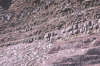
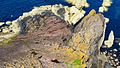
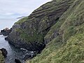
An unconformity is a buried erosional or non-depositional surface separating two rock masses or strata of different ages, indicating that sediment deposition was not continuous. In general, the older layer was exposed to erosion for an interval of time before deposition of the younger layer, but the term is used to describe any break in the sedimentary geologic record. The significance of angular unconformity was shown by James Hutton, who found examples of Hutton's Unconformity at Jedburgh in 1787 and at Siccar Point in Berwickshire in 1788, both in Scotland.
Sir James Hall of Dunglass, 4th Baronet FRS FRSE was a Scottish geologist and geophysicist. He was a Member of Parliament for St. Michael's borough 1807–1812.

The Moine Thrust Belt or Moine Thrust Zone is a linear tectonic feature in the Scottish Highlands which runs from Loch Eriboll on the north coast 190 kilometres (120 mi) south-west to the Sleat peninsula on the Isle of Skye. The thrust belt consists of a series of thrust faults that branch off the Moine Thrust itself. Topographically, the belt marks a change from rugged, terraced mountains with steep sides sculptured from weathered igneous, sedimentary and metamorphic rocks in the west to an extensive landscape of rolling hills over a metamorphic rock base to the east. Mountains within the belt display complexly folded and faulted layers and the width of the main part of the zone varies up to 10 kilometres (6.2 mi), although it is significantly wider on Skye.
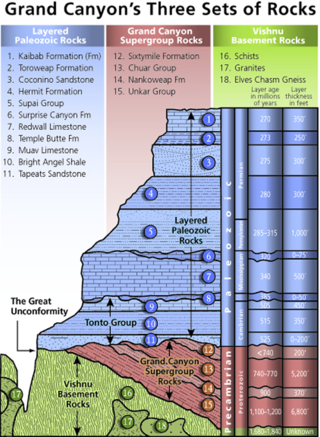
Of the many unconformities (gaps) observed in geological strata, the term Great Unconformity is frequently applied to either the unconformity observed by James Hutton in 1787 at Siccar Point in Scotland, or that observed by John Wesley Powell in the Grand Canyon in 1869. Both instances are exceptional examples of where the contacts between sedimentary strata and either sedimentary or crystalline strata of greatly different ages, origins, and structure represent periods of geologic time sufficiently long to raise great mountains and then erode them away.

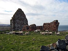
Cockburnspath is a village in Berwickshire in the Scottish Borders. It lies near the North Sea coast between Berwick-upon-Tweed and Dunbar. Cockburnspath is the eastern terminus of the Southern Upland Way as well as the northern terminus of the Berwickshire Coastal Path. At the nearby village of Cove, there is a small fishing harbour.
Plutonism is the geologic theory that the igneous rocks forming the Earth originated from intrusive magmatic activity, with a continuing gradual process of weathering and erosion wearing away rocks, which were then deposited on the sea bed, re-formed into layers of sedimentary rock by heat and pressure, and raised again. It proposes that basalt is solidified molten magma. The theory lead to plutonic (intrinsic) rock classification, which includes intrinsic igneous rocks such as gabbro, diorite, granite and pegmatite. The name plutonism references Pluto, the classical ruler of the underworld and the Roman god of wealth. A main reason Pluto was incorporated into the classification was due to the plutonic rocks commonly being present in gold and silver ore deposits (veins).

The geology of Scotland is unusually varied for a country of its size, with a large number of different geological features. There are three main geographical sub-divisions: the Highlands and Islands is a diverse area which lies to the north and west of the Highland Boundary Fault; the Central Lowlands is a rift valley mainly comprising Palaeozoic formations; and the Southern Uplands, which lie south of the Southern Uplands Fault, are largely composed of Silurian deposits.
In geology, the term Torridonian is the informal name for the Torridon Group, a series of Mesoproterozoic to Neoproterozoic arenaceous and argillaceous sedimentary rocks, which occur extensively in the Northwest Highlands of Scotland. The strata of the Torridonian Group are particularly well exposed in the district of upper Loch Torridon, a circumstance which suggested the name Torridon Sandstone, first applied to these rocks by James Nicol. Stratigraphically, they lie unconformably on gneisses of the Lewisian complex and their outcrop extent is restricted to the Hebridean Terrane.

The Jed Water is a river and a tributary of the River Teviot in the Borders region of Scotland.
Hutton's Unconformity is a name given to various notable geological sites in Scotland identified by the 18th-century Scottish geologist James Hutton as places where the junction between two types of rock formations can be seen. This geological phenomenon marks the location where rock formations created at different times and by different processes adjoin. For Hutton, such an unconformity provided evidence for his Plutonist theories of uniformitarianism and the age of Earth.
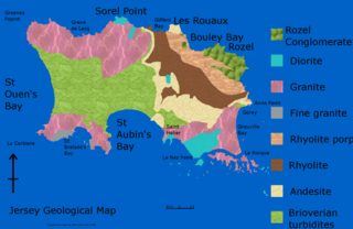
The geology of Jersey is characterised by the Late Proterozoic Brioverian volcanics, the Cadomian Orogeny, and only small signs of later deposits from the Cambrian and Quaternary periods. The kind of rocks go from conglomerate to shale, volcanic, intrusive and plutonic igneous rocks of many compositions, and metamorphic rocks as well, thus including most major types.
A stratigraphic column is a representation used in geology and its subfield of stratigraphy to describe the vertical location of rock units in a particular area. A typical stratigraphic column shows a sequence of sedimentary rocks, with the oldest rocks on the bottom and the youngest on top.

The Tonto Group is a name for an assemblage of related sedimentary strata, collectively known by geologists as a Group, that comprises the basal sequence Paleozoic strata exposed in the sides of the Grand Canyon. As currently defined, the Tonto groups consists of the Sixtymile Formation, Tapeats Sandstone, Bright Angel Shale, Muav Limestone, and Frenchman Mountain Dolostone. Historically, it included only the Tapeats Sandstone, Bright Angel Shale, and Muav Limestone. Because these units are defined by lithology and three of them interfinger and intergrade laterally, they lack the simple layer cake geology as they are typically portrayed as having and geological mapping of them is complicated.
Except where underlain by the Sixtymile Formation, the Tapeats Sandstone is the Cambrian geologic formation that is the basal geologic unit of the Tonto Group. Typically, it is also the basal geologic formation of the Phanerozoic strata exposed in the Grand Canyon, Arizona, and parts of northern Arizona, central Arizona, southeast California, southern Nevada, and southeast Utah. The Tapeats Sandstone is about 230 feet (70 m) thick, at its maximum. The lower and middle sandstone beds of the Tapeats Sandstone are well-cemented, resistant to erosion, and form brownish, vertical cliffs that rise above the underlying Precambrian strata outcropping within Granite Gorge. They form the edge of the Tonto Platform. The upper beds of the Tapeats Sandstone form the surface of the Tonto Platform. The overlying soft shales and siltstones of the Bright Angel Shale underlie drab-greenish slopes that rise from the Tonto Platform to cliffs formed by limestones of the Muav Limestone and dolomites of the Frenchman Mountain Dolostone.

Theory of the Earth was a publication by James Hutton which laid the foundations for geology. In it he showed that the Earth is the product of natural forces. What could be seen happening today, over long periods of time, could produce what we see in the rocks. It also hypothesized that the age of the Earth was much older than what biblical literalists claim. This idea, uniformitarianism, was used by Charles Lyell in his work, and Lyell's textbook was an important influence on Charles Darwin. The work was first published in 1788 by the Royal Society of Edinburgh, and later in 1795 as two book volumes.


