Silvassa

Last updated

Silvassa
City
Dadra and Nagar Haveli Silvassa 3.jpg
Silvassa Townhall
India location map.svg
Red pog.svg
Silvassa
India Dadra and Nagar Haveli location map.svg
Red pog.svg
Silvassa
India Gujarat location map.svg
Red pog.svg
Silvassa
Coordinates: 20°16′15″N73°00′18″E / 20.2708162°N 73.0049524°E / 20.2708162; 73.0049524
CountryFlag of India.svg  India
Union territory Dadra and Nagar Haveli and Daman and Diu emblem.png DNDD
District Dadra and Nagar Haveli
Government
  TypeMunicipal Council
  BodySilvassa Municipal Council
  MayorRakeshsinh Chauhan
Area
  Total16 km2 (6 sq mi)
Elevation
32 m (105 ft)
Population
 (2011)
  Total98,266
  Density6,100/km2 (16,000/sq mi)
Languages
  Official Hindi, English
  Additional official Gujarati [1]
Time zone UTC+5:30 (IST)
Telephone code0260
Vehicle registration DD-01
Website dnh.gov.in

Silvassa is a city and municipality in western India, and the headquarters of the Dadra and Nagar Haveli district. It was a part of the Daman district of the former Portuguese India, and is today the largest city in Dadra and Nagar Haveli and Daman and Diu. Many large companies have established their manufacturing units there. The city has a large number of factories providing significant government revenue, which allows the city to maintain a low level of taxation. The city was chosen as one of the hundred Indian cities in Government of India's flagship Smart Cities Mission.

Contents

Etymology

The former official name of the city, during Portuguese rule, was Paço de Arcos (Engl.: "palace of arches", also spelled Paço d'Arcos). [2]

History

Until about the turn of the century, in the late 1800s, Silvassa was one of many small villages in Portuguese India. Its importance started to increase by the mid-1880s when the Portuguese administration, under then Governor-General Carlos Eugénio Correia da Silva, Count of Paço de Arcos, decided to transfer the seat of the Pragana Nagar Avely municipality further inland from Darará. On 11 February 1885, by decree from the Portuguese Ministry of the Overseas, Silvassa was designated as a town (vila), and given the name of Paço de Arcos. [3] However, the endemic name prevailed, and the town continued to be known locally and beyond as Silvassa, being referred-to as such in official documents. The town remained the municipal capital until the Indian Annexation of 1954.

Demographics

According to the 2011 India census, [4] Silvassa had a population of 98,265.

Language

Gujarati and Hindi are the most commonly spoken languages in Silvassa; as the city lies in the northern part of Nagar Haveli, Gujarati and its dialects are more widely spoken compared to the southern part of Nagar Haveli, where Marathi, Konkani and its dialects hold prominence. As with most larger towns and cities in India (with a somewhat centralised location), Salvassa is home to people from virtually every part of the nation, with numerous languages being spoken there besides the widespread Hindi, Marathi or Gujarati; one may hear Bengali, Bhojpuri, Haryanvi, Kannada, Malayalam, Marwari, Odia, Punjabi, Tamil, Telugu or Urdu, amongst other tongues, when in Silvassa.

As a former Portuguese colony, Silvassa has a significant Roman Catholic population, and there are still a few citizens who speak Portuguese as their first or second language.

Industry

Vanganga Garden, Silvassa Vanganga Garden, Silvassa (32345632184).jpg
Vanganga Garden, Silvassa

Far from being a tribal region, Silvassa has now developed into an industrial hub with major industrial companies setting up manufacturing bases in the region. Its initial tax-free status granted by the Indian government to boost industrial investment in the former Union Territory of Dadra and Nagar Haveli has contributed to the region's industrial growth.[ citation needed ] The industrial landscape of Silvassa and surrounding region has been altered dramatically. It is one of the largest states in collection of excise duty from more than 3,500 small and medium industries. Silvassa is a big hub for plastic products and its products are found throughout India thanks to their good quality and low cost. Apart from all this, Silvassa is also known for various FMCG distributors like Gajra Distribution having reach throughout the country.

Silvassa hosts more than 200,000 floating population, coming from all parts of the country; the laborers mostly hail from Uttar Pradesh, Bihar and Odisha. Other floating community is from the states of Madhya Pradesh, Maharashtra, Gujarat, Kerala, Karnataka, Tamil Nadu, Andhra Pradesh, and Rajasthan.

Transport and connections

Silvassa is connected to Maharashtra and Gujarat via National Highway 848A. [5] Silvassa has a well-maintained road network. The nearest railway stations are in Vapi 16 kilometres (9.9 mi) away and Bhilad, 14 kilometres (8.7 mi) away. Daman is 30 km away via Bhilad on National Highway number 8. Mumbai is 160 km away from Silvassa, via Bhilad, on National Highway number 8 Surat is 130 km away from Silvassa, via Bhilad, on National Highway number 8. Auto-rickshaw services ply between Vapi and Silvassa at a regular interval and easily available from Vapi (E) railway station. Gujarat Road Transport Buses ply between Silvassa and Vapi at a regular interval.

Silvassa Smart City Limited currently operates 10 Electric Buses to and from the Silvassa Bus Stand, destinations include Daman, Vapi, Khanvel, Dudhani, and Mandoni.

See also

Related Research Articles

<span class="mw-page-title-main">Dadra and Nagar Haveli</span> District in Western India

Dadra and Nagar Haveli is a district of the union territory of Dadra and Nagar Haveli and Daman and Diu in western India. It is composed of two separate geographical entities: Nagar Haveli, wedged in between Maharashtra and Gujarat states 1 kilometre (0.62 mi) to the north-west, the smaller enclave of Dadra, which is surrounded by Gujarat. Silvassa is the administrative headquarters of Dadra and Nagar Haveli.

<span class="mw-page-title-main">Daman and Diu</span> Former union territory in western India

Daman and Diu was a union territory in northwestern India. With an area of 112 km2 (43 sq mi), it was the smallest administrative subdivision of India on the mainland. The territory comprised two districts, Daman and Diu island, geographically separated by the Gulf of Khambat. The state of Gujarat and the Arabian Sea bordered the territory. A Portuguese colony since the 1500s, the territories were taken by India with the Annexation of Goa in 1961. Daman and Diu were administered as part of the union territory of Goa, Daman and Diu between 1961 and 1987, after the Goa Opinion Poll they became a separate union territory. In 2019, legislation was passed to merge the union territory of Daman and Diu with its neighbouring union territory, Dadra and Nagar Haveli, to form the new union territory of Dadra and Nagar Haveli and Daman and Diu with effect from 26 January 2020.

<span class="mw-page-title-main">Valsad</span> City in Gujarat, India

Valsad, historically known as Bulsar, is a city and a municipality in Valsad district of the Indian state of Gujarat. It is the district headquarters of Valsad district. Valsad is located south of Navsari and shares border with Maharashtra and the union territories of Dadra and Nagar Haveli and Daman and Diu in the south.

<span class="mw-page-title-main">Vapi</span> City in Gujarat, India

Vapi, is a city and Municipal Corporation in Valsad district in the state of Gujarat, India. It is situated near the banks of the Daman Ganga River, around 28 km south of the district headquarters in the city of Valsad, and it is surrounded by the Union Territory of Dadra and Nagar Haveli and Daman and Diu. It is believed that the city got its name from the old small stepwell situated near the Balitha area. The meaning of vapi (वापी) in sanskrit is a water reservoir or a water storage body.

<span class="mw-page-title-main">Daman Ganga River</span> River in western India

The Daman Ganga also called Dawan River is a river in western India. The river's headwaters are on the western slope of the Western Ghats range, and it flows west into the Arabian Sea. The river flows through Maharashtra and Gujarat states, as well as the Union territory of Dadra and Nagar Haveli and Daman and Diu. The industrial towns of Vapi, Dadra and Silvassa lie on the north bank of the river, and the town of Daman occupies both banks of the river's estuary.

<span class="mw-page-title-main">Valsad district</span> District of Gujarat in India

Valsad district is one of the 33 districts in the Western Indian state of Gujarat. It is bound by Navsari district to the north, Nashik district of Maharashtra state to the east, and Dadra and Nagar Haveli district of the Dadra and Nagar Haveli and Daman and Diu (DNHDD) union territory and the Palghar district of Maharashtra to the south. The Arabian Sea lies west of the district. The coastal Damaon enclave of DNHDD is bounded by Valsad district on the north, east, and south. The district's administrative capital is Valsad. The district's largest city is Vapi.

Daman district, is one of four districts of the Indian union territory of Dadra and Nagar Haveli and Daman and Diu on the west coast of India. It is surrounded by the Valsad district of the Gujarat state to the north, east and south and the Arabian Sea to the west. The district has an area of 72 square kilometres (28 sq mi), and a population of 191,173 as of the 2011 census, an increase of 69.256% from the 2001 Census. The district headquarters is Daman. The previous territorial headquarters were in Panjim when it was jointly administered as Goa, Damaon & Diu until the time of the Konkani language agitation.

<span class="mw-page-title-main">Diu, India</span> City in Dadra and Nagar Haveli and Daman and Diu, India

Diu, also known as Diu Town, is a medieval fortified town in Diu district in the union territory of Dadra and Nagar Haveli and Daman and Diu, India. Diu district is the tenth least populated district of India. The town of Diu lies at the eastern end of Diu Island and is known for its fortress and old Portuguese cathedral. It is a fishing town.

<span class="mw-page-title-main">Diu district</span> District in Dadra and Nagar Haveli and Daman and Diu, India

Diu district is one of the three districts of the union territory of Dadra and Nagar Haveli and Daman and Diu of India. The district is made up of Diu Island and two small enclaves on the Indian mainland. The district headquarters are at Diu Town. It is the ninth least populous district in the country.

Daman is a city and also the administrative capital of the Indian of territory of Dadra and Nagar Haveli and Daman and Diu. It is a municipal council situated in the Daman district of the union territory.

<span class="mw-page-title-main">Dadra, Dadra and Nagar Haveli and Daman and Diu</span> Sub-district in DNDD, India

Dadra is one of the two talukas in Dadra and Nagar Haveli district, India. It is an enclave lying a few kilometres north west of Nagar Haveli and is surrounded by Gujarat.

<span class="mw-page-title-main">Nagar Haveli</span> Taluka in Dadra and Nagar Haveli and Daman and Diu, India

Nagar Haveli is one of the two talukas of Dadra and Nagar Haveli District, Dadra and Nagar Haveli and Daman and Diu, India. It is surrounded by the Indian states of Gujarat and Maharashtra.

<span class="mw-page-title-main">Annexation of Dadra and Nagar Haveli</span> Annexation of Dadra and Nagar Haveli by India

The Annexation of Dadra and Nagar Haveli was the conflict in which the territories of Dadra and Nagar Haveli passed from Portuguese rule to independent rule, with Indian allegiance, in 1954.

<span class="mw-page-title-main">Free Dadra and Nagar Haveli</span> Freedom struggle of Dadra and Nagar Haveli from the Portuguese

Free Dadra and Nagar Haveli was a de facto independent political entity that existed in the Indian Sub-continent between 1954 and 1961. It was declared by pro-India forces that had gained control of the region from Portugal in 1954 and ceased to exist after being formally annexed by India on 11 August 1961 as the Union Territory of Dadra and Nagar Haveli.

<span class="mw-page-title-main">Maghval</span> Village in Gujarat, India

Maghval, also known as Megwal and Meghwad, is a village in the Kaparada taluka of Valsad district in Gujarat State, India. It is a small enclave belonging to Gujarat, but located within Nagar Haveli, just south of Silvassa in the Indian union territory of Dadra and Nagar Haveli and Daman and Diu. In January 2022, the government of India announced plans for the Maghval enclave to become part of Dadra and Nagar Haveli and Daman and Diu but was deferred.

<span class="mw-page-title-main">National Highway 848A (India)</span> National highway in India

National Highway 848A, commonly called NH 848A is a national highway in India. It is a branch of National Highway 48. NH-848A traverses the states of Gujarat, Maharashtra and the union territory of Dadra and Nagar Haveli and Daman and Diu.

<span class="mw-page-title-main">Dadra and Nagar Haveli and Daman and Diu</span> Union territory of India

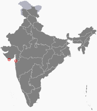
Dadra and Nagar Haveli and Daman and Diu is a union territory in India. The territory was constituted through the merger of the former territories of Dadra and Nagar Haveli and Daman and Diu. Plans for the proposed merger were announced by the Government of India in July 2019; the necessary legislation was passed in the Parliament of India in December 2019 and came into effect on 26 January 2020. The territory is made up of four separate geographical entities: Dadra, Nagar Haveli, Daman, and the island of Diu. All four areas were formerly part of Portuguese India, with a joint capital at Panjim, Goa. They came under Indian rule in the mid-20th century after the Annexation of Goa. These were jointly administered as Goa, Daman and Diu until 1987, when Goa was granted statehood after the Konkani language agitation. The current capital is Daman and Silvassa is the largest city.

<span class="mw-page-title-main">Shri Vinoba Bhave Institute of Medical Sciences</span> Indian government medical college in Silvassa

Vinoba Bhave Institute of Medical Sciences / NAMO Medical Education & Research Institute is a government medical college located in Silvassa in the Union Territory of Dadra and Nagar Haveli and Daman and Diu. The union government allocated the fund of 189 crore for its construction. The foundation stone was laid by the Prime Minister of India Shri Narendra Modi on 19 January 2019, and the first undergraduate batch commenced on 15 August 2019.

References

  1. "The Goa, Daman and Diu Official Language Act, 1987" (PDF). indiacode.nic.in. Retrieved 12 November 2022.
  2. "Silvassa – A City with Portugal History". 29 July 2017.
  3. "Decreto de 11 de fevereiro de 1885", Diário do Governo, 1885
  4. "Census of India 2001: Data from the 2001 Census, including cities, villages and towns (Provisional)". Census Commission of India. Archived from the original on 16 June 2004. Retrieved 1 November 2008.
  5. "New National Highways notification - NH 848A" (PDF). The Gazette of India . 17 April 2013. Archived (PDF) from the original on 21 May 2018. Retrieved 20 May 2018.