The Soudan Banks are a series of underwater high points and reefs off the coast of Africa, known for their good fishing yields as fishing banks. They are administered by Mauritius. The five banks (actually a single feature) lie on the Mascarene plateau. North Soudan contains large salmon stocks. South Soudan is the largest of the banks, with many reefs and passes. West Soudan is small, rocky, and shallow, and is the least fished of the banks. Central Soudan is the most fished area, with huge reefs and open waters containing a huge abundance of fish. East Soudan, until the 1970s, was considered to be a completely different formation altogether, since it is located more than 100 miles away from the other banks. The other banks are closely linked, separated by small shallows or channels.
Two million years ago, Soudan was a large island, as were Nazareth, Cargados Carajos and Saya de Malha. These islands were more than ten times the size of Mauritius and Reunion. However, they have submerged under the ocean, apart from some small islands in the Cargados Carajos.
This is a list of the lists of islands in the world grouped by country, by continent, by body of water, and by other classifications. For rank-order lists, see the other lists of islands below.
Mauritius is an island off Africa's southeast coast located in the Indian Ocean, east of Madagascar. It is geologically located within the Somali plate.
The Mascarene Islands or Mascarenes or Mascarenhas Archipelago is a group of islands in the Indian Ocean east of Madagascar consisting of islands belonging to the Republic of Mauritius as well as the French department of La Réunion. Their name derives from the Portuguese navigator Pedro Mascarenhas, who first visited them in April 1512. The islands share a common geological origin beneath the Mascarene Plateau known as the Mauritia (microcontinent) which was a Precambrian microcontinent situated between India and Madagascar until their separation about 70 million years ago. They form a distinct ecoregion with unique biodiversityand endemism of flora and fauna.
The Outer Islands of Mauritius is the first-level administrative divisions of the country and consists of the islands of Mauritius and several outlying islands. It is under the authority of the Ministry of Local Government and Outer Islands. The Constitution of Mauritius states that the Republic of Mauritius includes the islands of Agaléga, Mauritius, Rodrigues, Saint Brandon, Tromelin Island, and the Chagos Archipelago. The Government of Mauritius claims sovereignty over the Chagos Archipelago, which the United Kingdom split from its territories to create the British Indian Ocean Territory before its independence in 1968. Additionally, France shares a sovereignty claim over Tromelin Island, an uninhabited island between Madagascar and Mauritius's main island.
Saint Brandon, also known as the Cargados Carajos Shoals, is a southwest Indian Ocean archipelago of sand banks, shoals and islets belonging to the Republic of Mauritius. It lies about 430 km (270 mi) northeast of the island of Mauritius. It consists of five island groups, with about 28-40 islands and islets in total, depending on seasonal storms and related sand movements.
The Mascarene Plateau is a submarine plateau in the Indian Ocean, north and east of Madagascar. The plateau extends approximately 2,000 km (1,200 mi), from Seychelles in the north to Réunion in the south. The plateau covers an area of over 115,000 km2 (44,000 sq mi) of shallow water, with depths ranging from 8–150 m (30–490 ft), plunging to 4,000 m (13,000 ft) to the abyssal plain at its edges.
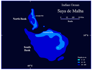
The Saya de Malha Bank or Mesh Skirt Bank, is one of the largest submerged ocean banks in the world, a part of the vast undersea Mascarene Plateau.
Nazareth Bank is a large submerged bank in the Indian Ocean.
Sepia mascarensis is a species of cuttlefish native to the western Indian Ocean, specifically Saya-de-Malha Bank, Mascarene Ridge, and Cargados-Carajos Shoals. It lives at depths of between 87 and 325 m.
Sepia plathyconchalis is a species of cuttlefish native to the western Indian Ocean, specifically the Saya-de-Malha Bank, Cargados-Carajos Shoals, and St Brandon Shoals. It lives in shallow waters at depths of between 25 and 63 m.
Hawkins Bank is a large submerged bank off the Mascarene Plateau. It is considered a dependency of Mauritius. The bank is abundant with fish and Mauritian vessels often fish in the waters in and around the bank.
The wildlife of Mauritius consists of its flora and fauna. Mauritius is located in the Indian Ocean to the east of Madagascar. Due to its isolation, it has a relatively low diversity of wildlife; however, a high proportion of these are endemic species occurring nowhere else in the world. Many of these are now threatened with extinction because of human activities including habitat destruction and the introduction of non-native species. Some have already become extinct, most famously the dodo which disappeared in the 17th century.
The following is an index of Mauritius-related topics by alphabetical order. For a list by topic, see list of Mauritius-related topics
The following outline is provided as an overview of and topical guide to the fishing industry:
Île Raphael is an island in the Saint Brandon archipelago, a group of 30 outer islands of Mauritius. The island is named after Veuve Raphaël. Veuve Raphaël's husband was a sea captain and had installations on the corner of rue (route) des Pamplemousses and rue Fanfaron in Port Louis. Captain Raphaël travelled regularly to Île Raphael, St Brandon from Port Louis and, on 17 May 1816 and November 1817, is on record as bringing back salted fish on a Lugger called 'Le Cheriby'. Île Raphaël is today the headquarters and principal fishing base of the Raphael Fishing Company which is the second oldest commercial company in Mauritius.
L'île du Sud is an island located in the St. Brandon archipelago. It is one of the three islands used as a base of operations for fishing activities by Raphael Fishing Company, the only resident fishing company in the cargados carajos shoals under a 1901 contract with the government of Mauritius.
L'Île Coco is one of the longest islands adjoining the inner lagoon of the St. Brandon archipelago. It is at times inhabited by fishermen as a base for the resident fishing company's fishing activities as well as for fly fishing and fly-casting activities.
The Raphaël Fishing Company Ltd is a Mauritian fishing company incorporated on 7 July 1927 in Port Louis, Mauritius. It is the second oldest commercial company in Mauritius, after Mauritius Commercial Bank (1828).
This page is based on this Wikipedia article Text is available under the CC BY-SA 4.0 license; additional terms may apply. Images, videos and audio are available under their respective licenses.