The Ute mythology is the mythology of the Ute people, a tribe of Native Americans from the Western United States.

Ouray was a Native American chief of the Tabeguache (Uncompahgre) band of the Ute tribe, then located in western Colorado. Because of his leadership ability, Ouray was acknowledged by the United States government as a chief of the Ute and he traveled to Washington, D.C. to negotiate for the welfare of the Utes. Raised in the culturally diverse town of Taos, Ouray learned to speak many languages that helped him in the negotiations, which were complicated by the manipulation of his grief over his five-year-old son, abducted during an attack by the Sioux. Ouray met with Presidents Lincoln, Grant, and Hayes and was called the "man of peace" because he sought to make treaties with settlers and the government.

The Tamástslikt Cultural Institute is a museum and research institute located on the Umatilla Indian Reservation near Pendleton in eastern Oregon. It is the only Native American museum along the Oregon Trail. The institute is dedicated to the culture of the Cayuse, Umatilla, and Walla Walla tribes of Native Americans. The main permanent exhibition of the museum provides a history of the culture of three tribes, and of the reservation itself. The museum also has a second hall for temporary exhibitions of specific types of Native American art, craftwork, history, and folklore related to the tribes.

The Southern Paiute people are a tribe of Native Americans who have lived in the Colorado River basin of southern Nevada, northern Arizona, and southern Utah. Bands of Southern Paiute live in scattered locations throughout this territory and have been granted federal recognition on several reservations. Southern Paiute's traditionally spoke Colorado River Numic, which is now a critically endangered language of the Numic branch of the Uto-Aztecan language family, and is mutually intelligible with Ute. The term Paiute comes from paa Ute meaning water Ute, and refers to their preference for living near water sources. Before European colonization they practiced springtime, floodplain farming with reservoirs and irrigation ditches for corn, squash, melons, gourds, sunflowers, beans and wheat.

Ute are the indigenous, or Native American people, of the Ute tribe and culture among the Indigenous peoples of the Great Basin. They had lived in sovereignty in the regions of present-day Utah and Colorado.

The Ute Mountain Ute Tribe is one of three federally recognized tribes of the Ute Nation, and are mostly descendants of the historic Weeminuche Band who moved to the Southern Ute reservation in 1897. Their reservation is headquartered at Towaoc, Colorado on the Ute Mountain Ute Indian Reservation in southwestern Colorado, northwestern New Mexico and small sections of Utah.
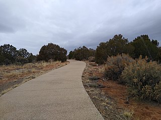
Hawkins Preserve is a 122-acre (0.49 km2) property within the city limits of Cortez, Colorado. It is protected by a conservation easement held by the Montezuma Land Conservancy.

Canyons of the Ancients National Monument is a national monument protecting an archaeologically significant landscape located in the southwestern region of the U.S. state of Colorado. The monument's 176,056 acres (71,247 ha) are managed by the Bureau of Land Management, as directed in the presidential proclamation which created the site on June 9, 2000. Canyons of the Ancients National Monument is part of the National Landscape Conservation System, better known as the National Conservation Lands. This system comprises 32 million acres managed by the Bureau of Land Management to conserve, protect, and restore these nationally significant landscapes recognized for their outstanding cultural, ecological, and scientific values. Canyons of the Ancients encompasses and surrounds three of the four separate sections of Hovenweep National Monument, which is administered by the National Park Service. The monument was proclaimed in order to preserve the largest concentration of archaeological sites in the United States, primarily Ancestral Puebloan ruins. As of 2022, over 8,500 individual archeological sites had been documented within the monument.
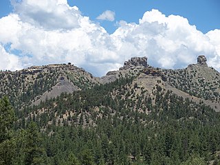
Chimney Rock National Monument is a 4,726-acre (1,913 ha) U.S. National Monument in San Juan National Forest in southwestern Colorado which includes an archaeological site. This area is located in Archuleta County, Colorado, between Durango and Pagosa Springs, and is managed for archaeological protection, public interpretation, and education. The Chimney Rock Archaeological Site has been listed on the National Register of Historic Places since 1970. U.S. President Barack Obama created Chimney Rock National Monument by proclamation on September 21, 2012, under authority of the Antiquities Act.

The Southern Ute Indian Reservation is an Indian reservation in southwestern Colorado, United States, near the northern New Mexico state line. Its territory consists of land from three counties; in descending order of surface area they are La Plata, Archuleta, and Montezuma Counties. The reservation has a land area of 1,058.785 sq mi (2,742.24 km²). Its largest communities are Ignacio and Arboles. The only other community that is recognized as a separate place by the Census Bureau is the CDP of Southern Ute, which lies just southeast of Ignacio.
Fort Garland (1858–1883), Colorado, United States, was designed to house two companies of soldiers to protect settlers in the San Luis Valley, then in the Territory of New Mexico. It was named for General John Garland, commander of the Military District of New Mexico.

Crow Canyon Archaeological Center is a 170-acre (69 ha) research center and "living classroom" located in southwestern Colorado, US, which offers experiential education programs for students and adults.

The Trail of the Ancients is a collection of National Scenic Byways located in the U.S. Four Corners states of Utah, Colorado, New Mexico, and Arizona. These byways comprise:

The Uncompahgre Ute or ꞌAkaꞌ-páa-gharʉrʉ Núuchi is a band of the Ute, a Native American tribe located in the US states of Colorado and Utah. In the Ute language, uncompahgre means "rocks that make water red." The band was formerly called the Tabeguache.
Matthew James Box is the former chairman of the Southern Ute Indian Tribe in southwestern Colorado, USA. He was elected in 2008 for a three-year term and assumed the chairmanship on 21 December 2008. Box replaced Clement Frost as chairman.

The following outline is provided as an overview of and topical guide to the prehistoric people of Colorado, which covers the period of when Native Americans lived in Colorado prior to contact with the Domínguez–Escalante expedition in 1776. People's lifestyles included nomadic hunter-gathering, semi-permanent village dwelling, and residing in pueblos.
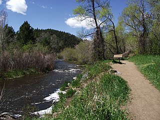
Bear Creek is a tributary of the South Platte River in central Colorado in the United States. It begins as a small creek up in the Mount Blue Sky Wilderness in Summit Lake and makes its way through Evergreen, CO, Kittredge, CO, Idledale, CO and Morrison, CO before entering Bear Creek Lake Park, managed by the City of Lakewood, Colorado.
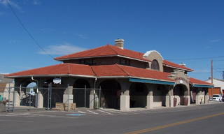
The Montrose County Historical Museum is located in Montrose, Colorado, USA, founded in 1973 by the Montrose County Historical Society. The society's mission is to preserve, display and interpret the historic and cultural legacy of Montrose County and its surrounding region. Its building, the Denver and Rio Grande Depot, is listed on the National Register of Historic Places.

Bears Ears National Monument is a United States national monument located in San Juan County in southeastern Utah, established by President Barack Obama by presidential proclamation on December 28, 2016. The monument protects 1,351,849 acres of public land surrounding the Bears Ears—a pair of buttes—and the Indian Creek corridor rock climbing area. The Native American names for the buttes have the same meaning in each of the languages represented in the region. The names are listed in the presidential proclamation as "Hoon’Naqvut, Shash Jáa [sic], Kwiyaghatʉ Nükavachi/Kwiyagatu Nukavachi, Ansh An Lashokdiwe"—all four mean "Bears Ears".

Nicaagat, also known as Chief, Captain and Ute Jack and Green Leaf. A Ute warrior and subchief, he led a Ute war party against the United States Army when it crossed Milk Creek onto the Ute reservation, which triggered the Battle of Milk Creek. Prior to the conflict, he had traveled to meet up with Major Thomas Tipton Thornburgh to learn of his intentions and warn him that crossing the Milk Creek onto the White River Ute reservation would be seen as an invasion and an act of war. When the army entered the reservation, a shooter from Nicaagat's band shot and killed Thornburgh.

