Ute Indian Tribe of the Uintah and Ouray Reservation

Last updated
Ute Indian Tribe
Núuchi-u
Ute warrior.jpg
Uintah Ute couple, northwestern Utah, 1874
Total population
2,647 (1990) [1]
Regions with significant populations
Flag of the United States.svg United States ( Flag of Utah.svg Utah)
Languages
English, Ute language
Religion
Christianity, Sun Dance, Native American Church, traditional tribal religion
Related ethnic groups
other Ute Tribes

The Ute Indian Tribe of the Uinta and Ouray Reservation is a Federally Recognized Tribe of Indians in northeastern Utah, United States. Three bands of Utes comprise the Ute Indian Tribe: the Whiteriver Band, the Uncompahgre Band and the Uintah Band. The Tribe has a membership of more than three thousand individuals, with over half living on the Uintah and Ouray Indian Reservation. [2] [ better source needed ] The Ute Indian Tribe operates its own tribal government and oversees approximately 1.3 million acres of trust land which contains significant oil and gas deposits. [2] [ better source needed ]

Contents

Historic bands

The Northern Ute tribe, which was moved to the Uintah Ouray Reservation, is composed of a number of bands. The tribes at the reservation include the following groups:

History

Utes have lived in the Great Basin region for over 10,000 years. From 3000 BCE to around 500 BCE, they lived along the Gila River in Arizona. People of the Fremont culture lived to the north in western Colorado, but when drought struck in the 13th century, they joined the Utes in San Luis Valley, Colorado. Utes were one of the first tribes to obtain horses from escaped Spanish stock.

Spanish explorers traveled through Ute land in 1776. They were followed by an ever-increasing number of non-Natives. The Colorado Gold Rush of the 1850s flooded Ute lands with prospectors. Mormons fought the Utes from the 1840s to 1870s. In the 1860s the US federal government created the Uintah Reservation. Specifically, an Act before the 38th Congress in May 1864 was passed to vacate and sell the Indian reservations in Utah and to settle the Indians of Utah in the Unita valley. The vacated land was sold in parcels “not exceeding 80 acres each” and the sale of the land was advertised in newspapers throughout the territories of Utah and Washington. The Act also authorized the superintendent of Indian Affairs to “collect and settle all or so many of the Indians of said territory as may be found practical in Unita Valley”. The Act also appropriated 30,000 dollars for the comfort of the Indians who inhabited Uinta Valley. Utah Utes, including the Timpanogos or Timpanog tribe from Central Utah, settled there in 1864, and were joined in 1882 by eight bands of Northern Utes.

As the United States began to expand, they created treaties, tract descriptions, and executive orders to outline the terms of Native land and mitigate tensions. The Uintah Ute Executive Order was a key document in outlining agreements for the Ouray Reservation. Robert MacFeely wrote this executive order requesting President Grover Cleveland to establish an American military base on a Native American Reservation. This military base would ultimately end up becoming Fort Duchesne. Robert MacFeely uses specific language in his appeal to the United States to lead the president to believe that this would be a mutually beneficial agreement. Throughout his account, he repeatedly uses the expression, "mutual agreement." [9] However, the Uintah Tribe has no incentive to want American military presence. This presence would reduce their autonomy and subjugate them to American rule. The United States' military presence makes it easy for them to kill or threaten any Natives, who oppose their rule. The presence of this military base would act as a way for the United States to control the Uintah people and assert their dominance. This military base ultimately resulted in the size of the Ute's land being decreased significantly. This massive military presence ultimately greatly decreases the size of the reservation. As the United States continues to push westward, they do so at the expense of Native Tribes.

The US government tried to force the Utes to farm, despite the lack of water and unfavorable growing conditions on their reservation. Irrigation projects of the early 20th century put water in non-tribal hands. Ute children were forced to attend Indian boarding schools in the 1880s and half of the Ute children at the Albuquerque Indian School died. [10]

In 1965, the Northern Ute Tribe agreed to allow the United States Bureau of Reclamation to divert a portion of its water from the Uinta Basin (part of the Colorado River Basin) to the Great Basin. The diversion would provide water supply for the Bonneville Unit of the Central Utah Project. In exchange, the Bureau of Reclamation agreed to plan and construct the Unitah, Upalco, and Ute Indian Units of the Central Utah Project to provide storage of the Tribe's water. By 1992, the Bureau of Reclamation had made little or no progress on construction of these facilities. To compensate the Tribe for the Bureau of Reclamation's failure to meet its 1965 construction obligations, Title V of the Central Utah Project Completion Act (P.L. 102-575), enacted in 1992, contains the Ute Indian Rights Settlement. Under the settlement, the Northern Tribe received $49.0 million for agricultural development, $29.5 million for recreation and fish and wildlife enhancement, and $125 million for economic development. The Ute Indian Rights Settlement is administered by the United States Department of the Interior.[ citation needed ]

Government

The Tribal Business Committee is the governing council of the Tribe and is located in Fort Duchesne, Utah. [11]

Reservation

The Uinta and Ouray Indian Reservation is the second-largest Indian Reservation in the US – covering over 4,500,000 acres (18,000 km2) of land. [2] [12] Tribal owned lands only cover approximately 1.2 million acres (4,855 km2) of surface land and 40,000 acres (160 km2) of mineral-owned land within the 4 million acres (16,185 km2) reservation area. [12] Founded in 1861, it is located in Carbon, Duchesne, Grand, Uintah, Utah, and Wasatch Counties in Utah. [1]

Raising stock and oil and gas leases are important revenue streams for the reservation. The Tribe is a member of the Council of Energy Resource Tribes. The Tribe holds a 5% stake in the proposed Uinta Basin Rail. [13]

Language & Tradition

The Ute language is a Proto-Numic language within the Uto-Aztecan language family. [14] The language is still widely spoken. In 1984, the tribe declared the Ute language to be the official language of their reservation, and the Ute Language, Culture and Traditions Committee provides language education materials. [15]

There are two annual dances that are performed by the Uintah Ute. The summer Sun Dance and the spring Bear Dance were particularly meaningful to their tribe. Their attitude towards the Bear Dance involves emphasis rather than innovations. The ceremonial aspect has gone, but the social aspects still remains. It offers a way for natives to grow closer to one another. [16]

Notes

  1. 1 2 Pritzker, 245
  2. 1 2 3 "Home". www.utetribe.com. Retrieved 2018-04-16.
  3. 1 2 3 4 "History of the Southern Ute". Southern Ute Indian Tribe. Retrieved June 18, 2018.
  4. Simmons, Virginia McConnell (September 15, 2001). The Ute Indians of Utah, Colorado, and New Mexico. University Press of Colorado. p. PT33. ISBN   978-1-60732-116-3.
  5. "The Timpanogos Nation: Uinta Valley Reservation". www.timpanogostribe.com. Retrieved June 18, 2018.
  6. Bakken, Gordon Morris; Kindell, Alexandra (February 24, 2006). Encyclopedia of Immigration and Migration in the American West. SAGE. p. PT740. ISBN   978-1-4129-0550-3.
  7. Carson, Phil (1998). Across the Northern Frontier: Spanish Explorations in Colorado. Big Earth Publishing. p. 103. ISBN   978-1-55566-216-5.
  8. "Frontier in Transition: A History of Southwestern Colorado (Chapter 5)". National Park Service. Retrieved June 18, 2018.
  9. http://ops.libs.uga.edu/ehistory/InvasionOfAmerica/ExecOrdersIndianLand/432r.pdf.{{cite web}}: Missing or empty |title= (help)
  10. Pritzker, 243
  11. "Business Committee". www.utetribe.com. Retrieved 2018-04-16.
  12. 1 2 UINTAH AND OURAY RESERVATION (PDF) (PDF), Bureau of Indian Affairs, n.d.
  13. "Tribe Backs Uinta Basin Railroad Construction". railfan.com. White River Productions. September 30, 2021.
  14. Pritzker, 242
  15. "Ute Language Policy." Cultural Survival. Issue 9.2, Summer 1985 (retrieved 5 May 2010)
  16. Steward, Julian H. (1932). "A Uintah Ute Bear Dance, March, 1931". American Anthropologist. 34 (2): 263–273. doi:10.1525/aa.1932.34.2.02a00060. JSTOR   661655.

Related Research Articles

<span class="mw-page-title-main">Uintah County, Utah</span> County in Utah, United States

Uintah County is a county in the U.S. state of Utah. As of the 2020 United States Census the population was 35,620. Its county seat and largest city is Vernal. The county was named for the portion of the Ute Indian tribe that lived in the basin.

<span class="mw-page-title-main">Ouray (Ute leader)</span> Native American leader

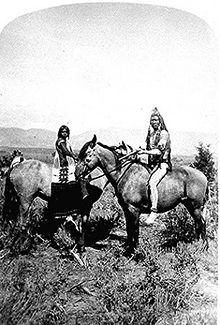
Ouray was a Native American chief of the Tabeguache (Uncompahgre) band of the Ute tribe, then located in western Colorado. Because of his leadership ability, Ouray was acknowledged by the United States government as a chief of the Ute and he traveled to Washington, D.C. to negotiate for the welfare of the Utes. Raised in the culturally diverse town of Taos, Ouray learned to speak many languages that helped him in the negotiations, which were complicated by the manipulation of his grief over his five-year-old son, abducted during an attack by the Sioux. Ouray met with Presidents Lincoln, Grant, and Hayes and was called the "man of peace" because he sought to make treaties with settlers and the government.

<span class="mw-page-title-main">Indigenous peoples of the Great Basin</span> Cultural classification of Native Americans

The Indigenous peoples of the Great Basin are Native Americans of the northern Great Basin, Snake River Plain, and upper Colorado River basin. The "Great Basin" is a cultural classification of indigenous peoples of the Americas and a cultural region located between the Rocky Mountains and the Sierra Nevada, in what is now Nevada, and parts of Oregon, California, Idaho, Wyoming, and Utah. The Great Basin region at the time of European contact was ~400,000 sq mi (1,000,000 km2). There is very little precipitation in the Great Basin area which affects the lifestyles and cultures of the inhabitants.

<span class="mw-page-title-main">Ute people</span> Native American people in the United States

Ute are the indigenous, or Native American people, of the Ute tribe and culture among the Indigenous peoples of the Great Basin. They had lived in sovereignty in the regions of present-day Utah and Colorado.

<span class="mw-page-title-main">Ute Mountain Ute Tribe</span> Reservation

The Ute Mountain Ute Tribe is one of three federally recognized tribes of the Ute Nation, and are mostly descendants of the historic Weeminuche Band who moved to the Southern Ute reservation in 1897. Their reservation is headquartered at Towaoc, Colorado on the Ute Mountain Ute Indian Reservation in southwestern Colorado, northwestern New Mexico and small sections of Utah.

<span class="mw-page-title-main">Southern Ute Indian Reservation</span> Indian reservation in United States, Southern Ute

The Southern Ute Indian Reservation is an Indian reservation in southwestern Colorado, United States, near the northern New Mexico state line. Its territory consists of land from three counties; in descending order of surface area they are La Plata, Archuleta, and Montezuma Counties. The reservation has a land area of 1,058.785 sq mi (2,742.24 km²). Its largest communities are Ignacio and Arboles. The only other community that is recognized as a separate place by the Census Bureau is the CDP of Southern Ute, which lies just southeast of Ignacio.

<span class="mw-page-title-main">Uintah and Ouray Indian Reservation</span> Native American reservation in Utah, United States

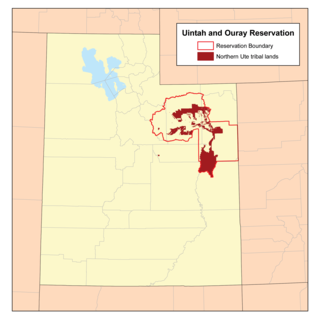
The Uintah and Ouray Indian Reservation is located in northeastern Utah, United States. It is the homeland of the Ute Indian Tribe, and is the largest of three Indian reservations inhabited by members of the Ute Tribe of Native Americans.

<span class="mw-page-title-main">Uinta Basin</span> Geologic structural basin in eastern Utah, US

The Uinta Basin is a physiographic section of the larger Colorado Plateaus province, which in turn is part of the larger Intermontane Plateaus physiographic division. It is also a geologic structural basin in eastern Utah, east of the Wasatch Mountains and south of the Uinta Mountains. The Uinta Basin is fed by creeks and rivers flowing south from the Uinta Mountains. Many of the principal rivers flow into the Duchesne River which feeds the Green River—a tributary of the Colorado River. The Uinta Mountains form the northern border of the Uinta Basin. They contain the highest point in Utah, Kings Peak, with a summit 13,528 feet above sea level. The climate of the Uinta Basin is semi-arid, with occasionally severe winter cold.

The Central Utah Project is a US federal water project that was authorized for construction under the Colorado River Storage Project Act of April 11, 1956, as a participating project. In general, the Central Utah Project develops a portion of Utah's share of the yield of the Colorado River, as set out in the Colorado River Compact of 1922.

In Section 203(a) of the Central Utah Project Completion Act, the United States Congress authorized a federally authorized and funded replacement project to replace the Uinta and Upalco Units of the Central Utah Project (CUP) which were not constructed. The replacement project is the Uinta Basin Replacement Project (UBRP). The UBRP will provide: 2,500 acre-feet (3,100,000 m3) of irrigation water; 3,000 acre-feet (3,700,000 m3) of municipal and industrial water; reduced wilderness impacts; increased instream flows; and improved recreation. Design work began in 2002. Construction began in 2004 and is anticipated to be completed in 2011. The Central Utah Water Conservancy District is responsible for construction. The United States Department of the Interior oversees funding and compliance with law and environmental regulation.

<span class="mw-page-title-main">Timpanogos</span> Native American tribe

The Timpanogos are a tribe of Native Americans who inhabited a large part of central Utah, in particular, the area from Utah Lake east to the Uinta Mountains and south into present-day Sanpete County.

White River Utes are a Native American band, made of two earlier bands, the Yampa from the Yampa River Valley and the Parianuche Utes who lived along the Grand Valley in Colorado and Utah.

<span class="mw-page-title-main">Chipeta</span> Native American leader

Chipeta or White Singing Bird was a Native American leader, and the second wife of Chief Ouray of the Uncompahgre Ute tribe. Born a Kiowa Apache, she was raised by the Utes in what is now Conejos, Colorado. An advisor and confidant of her husband, Chipeta continued as a leader of her people after his death in 1880.

<span class="mw-page-title-main">Duchesne River</span> River in Utah, United States

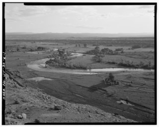
The Duchesne River, located in the Uintah Basin region of Utah in the western United States, is a tributary of the Green River. The watershed of the river covers the Northeastern corner of Utah. The Duchesne River is 115 miles (185 km) long, and drains a total land area of 3,790 square miles (9,800 km2).

The Uintah tribe, once a small band of the Ute people, and now is a tribe of multiple bands of Utes that were classified as Uintahs by the U.S. government when they were relocated to the Ute Indian Tribe of the Uintah and Ouray Reservation. The bands included the San Pitch, Pahvant, Seuvartis, Timpanogos and Cumumba Utes.

Ouray is an unincorporated village of the Uintah and Ouray Indian Reservation, located in west‑central Uintah County, Utah, United States.

<span class="mw-page-title-main">San Pitch Utes</span>

The San Pitch Utes were members of a band of Ute people that lived in the Sanpete Valley and Sevier River Valley and along the San Pitch River. They may have originally been Shoshonean, and were generally considered as part of the Timpanogos.

<span class="mw-page-title-main">Seuvarits Utes</span> Band of the Northern Ute Native American tribe

The Seuvarits Utes are a band of the Northern Ute tribe of Native Americans that traditionally inhabited the area surrounding present-day Moab, Utah, near the Grand River and the Green River. The Seuvarits were among the Ute bands that were involved in the Black Hawk War. The Seuvarits and other Ute bands were eventually relocated onto reservations by the United States government after their population severely declined after exposure to disease and war during the latter half of the 19th century.

<span class="mw-page-title-main">Nicaagat</span> Ute leader

Nicaagat, also known as Chief, Captain and Ute Jack and Green Leaf. A Ute warrior and subchief, he led a Ute war party against the United States Army when it crossed Milk Creek onto the Ute reservation, which triggered the Battle of Milk Creek. Prior to the conflict, he had traveled to meet up with Major Thomas Tipton Thornburgh to learn of his intentions and warn him that crossing the Milk Creek onto the White River Ute reservation would be seen as an invasion and an act of war. When the army entered the reservation, a shooter from Nicaagat's band shot and killed Thornburgh.

The Strawberry Valley Project was an early project planned and constructed by the Reclamation Service in the Uinta Basin of Utah. Reclamation approved the project in 1905, and in 1908 the project became the first for the Service to generate hydropower. The project is also notable for its interbasin transfer of water, from the Uinta Basin in the Colorado River major watershed to the Bonneville Basin in the Great Basin major watershed, accomplished through the four-mile long Strawberry Tunnel.

References