Stokesley

Last updated

Stokesley
Stokesley High Street (geograph 5712241).jpg
Stokesley Town Centre
North Yorkshire UK location map (2023).svg
Red pog.svg
Stokesley
Location within North Yorkshire
Population4,757 (2011 census) [1]
OS grid reference NZ524087
Unitary authority
Ceremonial county
Region
Country England
Sovereign state United Kingdom
Post town MIDDLESBROUGH
Postcode district TS9
Dialling code 01642
Police North Yorkshire
Fire North Yorkshire
Ambulance Yorkshire
UK Parliament
List of places
UK
England
Yorkshire
54°28′16″N1°11′26″W / 54.4712°N 1.1905°W / 54.4712; -1.1905

Stokesley is a market town and civil parish in North Yorkshire, England. It lies within the historic county boundaries of the North Riding of Yorkshire, on the River Leven. An electoral ward of the same name stretches north to Newby and had a population at the 2011 Census of 5,537. [2]

Contents

Stokesley is about two miles south of the Middlesbrough borough boundary and eight miles south of Middlesbrough town centre. Stokesley is between Middlesbrough, Guisborough and Northallerton in a farming area. Local attractions nearby include Great Ayton, Captain Cook's monument and Roseberry Topping in the North York Moors National Park. From 1894 to 1974 the town was one of the North Riding of Yorkshire's rural district head towns.

History

Market day with Stokesley Town Hall in the background Market Day in Stokesley - geograph.org.uk - 15330.jpg
Market day with Stokesley Town Hall in the background
Three Tuns Wynd leading from the High Street to North Road Alleyway to North Street - geograph.org.uk - 438356.jpg
Three Tuns Wynd leading from the High Street to North Road

Stokesley was granted a charter to hold fairs in 1223 by Henry III. The pack-horse bridge over the River Leven dates from the 17th century. Its large range of building types, including fine Georgian architecture, has contributed to its character. Prominent historical features include the Mill Wheel, thought to represent the site of a mill recorded in Domesday Book of 1086. Domesday also recorded "a church and priest" in Stokesley. Stokesley Town Hall was completed in 1853. [3]

Economy

Co-operative Food Supermarket in Stokesley before refurbishment The Co-operative supermarket at Stokesley - geograph.org.uk - 1700989.jpg
Co-operative Food Supermarket in Stokesley before refurbishment

The historic High Street is lined with independent small shops and restaurants. Other facilities include a medium-sized Co-operative Food supermarket, showground, camping site, health centre, industrial estate, library, police and fire stations. The town has five pubs (The Queen's Head, The White Swan, The Mill, The Spread Eagle and The Green Man). Stokesley is also the home of Quorn, produced by Marlow Foods.

There are 80 grade II listed buildings, along with four Grade II* listed buildings of special architectural or historic interest. They are the former Barclays Bank, Handyside Cottage, the Manor House and the Old Rectory. [4]

Agriculture

The market square The Market Square, Stokesley - geograph.org.uk - 517623.jpg
The market square

The inaugural meeting of Stokesley Agricultural Society was held at the Golden Lion Hotel, now The Leven Hotel, in 1859. The hotel was also used as the law court for the area being placed between Middlesbrough and Northallerton. Stokesley Agricultural Show, first held in 1859, is held every year on the first Saturday after the third Thursday in September (sounds odd, but historically the show was held on the third Thursday in September). It is one of the largest one day shows in the northern England. [5] A weekly market is also held each Friday in the main square called the Plain, a farmers' market also takes place on the first Saturday of each month.

Fair

Stokesley Fair Stokesley Fair 2007 - geograph.org.uk - 563672.jpg
Stokesley Fair

A four-day fair takes place in September in the town centre. The fair stretches the full length of the high street and rides such as Speed Buzz, the Extreme, Vertigo, King Frog, Cyclone and various Crows rides attend. The fair begins on Wednesday evening and runs until Saturday, opening all day on the Saturday at the same time as the annual agricultural show on the showground. [6]

Religion

Stokesley Methodist Church Stokesley Methodist Church - geograph.org.uk - 517632.jpg
Stokesley Methodist Church

There are three churches in Stokesley. One of these, the Anglican Church of St Peter and St Paul, is the oldest building in town, and it is just off the Market Plain. It has a medieval tower and chancel, a Georgian nave built around 1777, colourful 20th-century stained glass and woodwork carved by the Mouseman of Kilburn. [7]

Sport

The local leisure Centre Stokesley Leisure Centre - geograph.org.uk - 1705209.jpg
The local leisure Centre

Stokesley SC Football Club currently compete in the North Riding League Premier Division, which was founded in 1920. The North Riding County FA is based in the town. The county FA formed in 1881. Stokesley Cricket Club play in the North Yorkshire and South Durham Cricket League. The local leisure centre has a swimming pool.

Transport

Stokesley is served by the Arriva North East service 28a from Middlesbrough every hour and the 81 from Marske Estate every hour. Abbott's of Leeming run services 80/89, which run every two hours. The services operate six days a week towards Northallerton and Romanby via Osmotherley.

Stokesley was served by the Stokesley railway station and some sidings, on the Stockton-Picton-Battersby-Whitby branch. The station closed to passengers in June 1954, pre-dating the large scale closures of the Beeching cuts. Goods facilities remained until August 1965 when the line closed completely. The station featured in British Transport Films' "A Farmer Moves South" in 1951. The nearest railway station is now at Great Ayton.

Media

Local news and television programmes are provided by BBC North East and Cumbria and ITV Tyne Tees. Television signals are received from the Bilsdale TV transmitter. [8]

Local radio stations are BBC Radio Tees on 95.0 FM, Capital North East on 106.4 FM, Smooth North East on 107.7 FM, and Heart North East on 100.7 FM.

The town is served by the local newspapers, Darlington & Stockton Times and The Northern Echo . [9] [10]

Education

Historic schools include Preston Grammar School in College Square, now a pizza takeaway. In 1918 it was closed for failing to reach the standards of an inspection, primarily caused by lack of funds. Most children who passed the 11+ exam then went to Yarm Grammar School, with some Catholic pupils going to Middlesbrough under the old system.

Stokesley Primary School was created in 1908 and extended in 1973. It has about 550 pupils.

Stokesley School, [11] opened in 1959 [12] for pupils between 11 and 18, was originally a secondary modern and became a comprehensive school in the 1970s. Later a sixth form college was incorporated. It currently has about 1,700 pupils. Alumni of Stokesley School include Labour politician Alan Milburn, 1988 Olympics runner Louise Stuart and Sky Sports News journalist and presenter David Jones.

Notable people

Related Research Articles

<span class="mw-page-title-main">North Yorkshire</span> County of England

North Yorkshire is a ceremonial county in the Yorkshire and the Humber and North East regions of England. It borders County Durham to the north, the North Sea to the east, the East Riding of Yorkshire to the south-east, South Yorkshire to the south, West Yorkshire to the south-west, and Cumbria and Lancashire to the west. Northallerton is the county town.

<span class="mw-page-title-main">Guisborough</span> Market town in North Yorkshire, England

Guisborough is a market town and civil parish in the borough of Redcar and Cleveland, North Yorkshire, England. It lies north of the North York Moors National Park. Roseberry Topping, midway between the town and Great Ayton, is a landmark in the national park. At the 2011 census, the civil parish with outlying Upleatham, Dunsdale and Newton under Roseberry had a population of 17,777, of which 16,979 were in the town's built-up area. It was governed by an urban district and rural district in the North Riding of Yorkshire.

<span class="mw-page-title-main">Yarm</span> Town and civil parish in North Yorkshire, England

Yarm, also referred to as Yarm-on-Tees, is a market town and civil parish in the Borough of Stockton-on-Tees, North Yorkshire, England. It is in Teesdale with a town centre on a small meander of the River Tees. To the south-east, it extends to the River Leven, to the south it extends into the Kirklevington.

<span class="mw-page-title-main">North Riding of Yorkshire</span> Third of a historic county in England

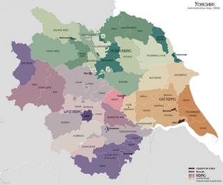
The North Riding of Yorkshire was a subdivision of Yorkshire, England, alongside York, the East Riding and West Riding. The riding's highest point was at Mickle Fell at 2,585 ft (788 m).

<span class="mw-page-title-main">Northallerton</span> Town in North Yorkshire, England

Northallerton is a market town and civil parish in North Yorkshire, England. It is near the River Wiske in the Vale of Mowbray and had a population of 16,832 in 2011. Northallerton is an administrative centre for York and North Yorkshire Combined Authority and North Yorkshire Council.

<span class="mw-page-title-main">Bedale</span> Market town and civil parish in North Yorkshire, England

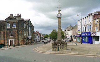
Bedale, is a market town and civil parish in North Yorkshire, England. Historically part of the North Riding of Yorkshire, it is 34 miles (55 km) north of Leeds, 26 miles (42 km) south-west of Middlesbrough and 7 miles (11 km) south-west of the county town of Northallerton. It was originally in Richmondshire and listed in Domesday Book as part of Catterick wapentake, which was also known as Hangshire ; it was split again and Bedale remained in East Hang. Bedale Beck is a tributary of the River Swale, which forms one of the Yorkshire Dales, with its predominance of agriculture and its related small traditional trades, although tourism is increasingly important.

<span class="mw-page-title-main">BBC Radio Tees</span> Radio station in Middlesbrough

BBC Radio Tees is the BBC's local radio station serving the Tees Valley and the northern parts of North Yorkshire, including Whitby. It broadcasts on FM, DAB, digital TV and via BBC Sounds from studios on Newport Road in Middlesbrough.

<span class="mw-page-title-main">Ingleby Barwick</span> Town and civil parish in North Yorkshire, England

Ingleby Barwick is a town and civil parish in the Borough of Stockton-on-Tees, North Yorkshire, England. It is south of the River Tees and north-east of the River Leven.

<span class="mw-page-title-main">River Leven, North Yorkshire</span> River in North Yorkshire, England

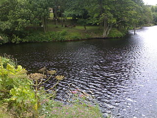
The River Leven in North Yorkshire, England is a tributary of the River Tees. It rises on Warren Moor, part of Kildale Moor, in the North York Moors and flows to the north of the moors to join the River Tees at Yarm.

<span class="mw-page-title-main">Great Ayton</span> Village and civil parish in North Yorkshire, England

Great Ayton is a village and civil parish in North Yorkshire, England. The River Leven flows through the village, which lies just north of the North York Moors. According to the 2011 Census, the parish has a population of 4,629.

<span class="mw-page-title-main">Hawes</span> Market town and civil parish in North Yorkshire, England

Hawes is a market town and civil parish in North Yorkshire, England, at the head of Wensleydale in the Yorkshire Dales, and historically in the North Riding of Yorkshire. The River Ure north of the town is a tourist attraction in the Yorkshire Dales National Park.

<span class="mw-page-title-main">Leyburn</span> Market town and civil parish in North Yorkshire, England

Leyburn is a market town and civil parish in North Yorkshire, England, sitting above the northern bank of the River Ure in Wensleydale. Historically in the North Riding of Yorkshire, the name was derived from 'Ley' or 'Le' (clearing), and 'burn' (stream), meaning clearing by the stream. Leyburn had a population of 1,844 at the 2001 census increasing to 2,183 at the 2011 Census. The estimated population in 2015 was 2,190.

<span class="mw-page-title-main">Great Ayton railway station</span> Railway station in North Yorkshire, England

Great Ayton is a railway station on the Esk Valley Line, which runs between Middlesbrough and Whitby via Nunthorpe. The station, situated 8 miles 37 chains (13.6 km) south-east of Middlesbrough, serves the village of Great Ayton, Hambleton in North Yorkshire, England. It is owned by Network Rail and managed by Northern Trains.

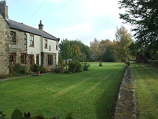
High Leven is a village of Ingleby Barwick in North Yorkshire, England. It is in the borough of Stockton-on-Tees, on top of the River Leven's dell. It has a public house called The Fox Covert and a co-operative food store, open every day 05:00 to 24:00, with an ATM and petrol station.

<span class="mw-page-title-main">Langbaurgh West</span> Ancient division of the North Riding, Yorkshire, England

Langbaurgh West was a division of the wapentake of Langbaurgh in the North Riding of the ancient county of Yorkshire. The area along with Langbaurgh East forms the Anglo-Saxon baronial Liberty of Cleveland and roughly covers the modern districts of Middlesbrough, the western, urbanised portion of Redcar & Cleveland, the southern portion of Stockton-on-Tees, the northern parts of Hambleton and the northern parts of the Borough of Scarborough.

<span class="mw-page-title-main">Hutton Rudby</span> Village and civil parish in North Yorkshire, England

Hutton Rudby is a village and civil parish situated 4 miles (6.4 km) west of the market town of Stokesley in North Yorkshire, England. At the 2011 census, the village's parish and built-up area subdivision had a population of 1,572 while its main population had a population of 1,968.

<span class="mw-page-title-main">Swainby</span> Village in North Yorkshire, England

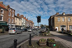
Swainby is a village in the Hambleton District of North Yorkshire, England. It is situated on the A172 road, 8 miles (13 km) north-east from Northallerton and 5 miles (8 km) south-east from the small market town of Stokesley.

The High Sheriff of Cleveland was a High Sheriff title which was in existence from 1974 until 1996, covering Cleveland, England.

<span class="mw-page-title-main">Ingleby railway station</span> Disused railway station in North Yorkshire, England

Ingleby railway station was a railway station built to serve the village of Ingleby Greenhow in North Yorkshire, England. The station was on the North Yorkshire and Cleveland's railway line between Sexhow and Ingleby, which opened in 1857. The line was extended progressively until it met the Whitby & Pickering Railway at Grosmont. Ingleby station was closed in 1954 to passengers and four years later to goods. The station was located 19 miles (31 km) south of Stockton, and only 0.75 miles (1.21 km) west of Battersby railway station.

<span class="mw-page-title-main">Stokesley railway station</span> Disused railway station in North Yorkshire, England

Stokesley railway station was a railway station built to serve the town of Stokesley in North Yorkshire, England. The station was on the North Yorkshire and Cleveland line between Sexhow and Ingleby, which opened in 1857. The line was extended progressively until it met the Whitby & Pickering Railway at Grosmont. It was closed in 1954 to passengers and eleven years later to goods. The station was located 16 miles (26 km) south of Stockton and 3.5 miles (5.6 km) west of Battersby station.

References

  1. UK Census (2011). "Local Area Report – Stokesley Parish (1170216930)". Nomis. Office for National Statistics . Retrieved 11 June 2018.
  2. UK Census (2011). "Local Area Report – Stokesley 2011 Census Ward (1237325081)". Nomis. Office for National Statistics . Retrieved 11 June 2018.
  3. Historic England. "Town Hall (1315445)". National Heritage List for England . Retrieved 12 March 2022.
  4. "The National Heritage List for England". English Heritage. Archived from the original on 27 March 2014. Retrieved 11 December 2013.
  5. Lodge, Bethany (17 September 2016). "Stokesley Show 2016: September sun shines down on 144th show". Gazette Live. Archived from the original on 1 July 2019. Retrieved 1 July 2019.
  6. "Stokesley Show". www.stokesleyshow.co.uk. Archived from the original on 7 March 2018. Retrieved 22 April 2018.
  7. "Home". www.robertthompsons.co.uk. Archived from the original on 23 April 2018. Retrieved 22 April 2018.
  8. "Bilsdale (North Yorkshire, England) Full Freeview transmitter". UK Free TV. 1 May 2004. Archived from the original on 26 October 2023. Retrieved 29 October 2023.
  9. "Darlington & Stockton Times". British Papers. 8 August 2013. Archived from the original on 29 October 2023. Retrieved 29 October 2023.
  10. "The Northern Echo". British Papers. 12 May 2014. Archived from the original on 28 October 2023. Retrieved 29 October 2023.
  11. http://stokesleyschool.org Archived 24 January 2013 at the Wayback Machine Stokesley School
  12. The Buildings of England Yorkshire The North Riding, N. Pevsner, Penguin Books, 1966
  13. The Newcastle Magazine. Vol. 6. W. A. Mitchell. 1827. p. 192.
  14. "Ruffer LLP pays member of firm £18m". The Yorkshire Post. 28 December 2014. Archived from the original on 26 January 2020. Retrieved 26 January 2020.

Further reading

Videos