A stratocumuluscloud, occasionally called a cumulostratus, belongs to a genus-type of clouds characterized by large dark, rounded masses, usually in groups, lines, or waves, the individual elements being larger than those in altocumulus, and the whole being at a lower height, usually below 2,000 metres (6,600ft).[1][2] Weak convectivecurrents create shallow cloud layers (see also: sea of clouds) because of drier, stable air above preventing continued vertical development. Historically, in English, this type of cloud has been referred to as a twain cloud for being a combination of two types of clouds.
Stratocumulus clouds are rounded clumps or patches of white to dark gray clouds that normally form in groups. The individual cloud elements, which cover more than 5 degrees of arc each, can connect with each other and are sometimes arranged in a regular pattern.[3][4][5]
Occurrence
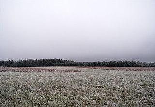
Vast areas of subtropical and polaroceans are covered with massive sheets of stratocumulus. These may organize into distinctive patterns which are currently under active study. In subtropics, they cover the edges of the horse latitude climatological highs, and reduce the amount of solar energy absorbed in the ocean. When these drift over land the summer heat or winter cold is reduced. 'Dull weather' is a common expression incorporated with overcast stratocumulus days, which usually occur either in a warm sector between a warm and cold front in a depression, or in an area of high pressure, in the latter case, sometimes persisting over a specific area for several days. If the air over land is moist and hot enough, stratocumulus may develop to various cumulus clouds, or, more commonly, the sheet of stratocumulus may become thick enough to produce some light rain. On drier areas they quickly dissipate over land, resembling cumulus humilis. This often occurs in late morning in areas under anticyclonic weather, the stratocumulus breaking up under the sun's heat and often reforming again by evening as the heat of the sun decreases again.
Precipitation
Most often, stratocumulus produce no precipitation, and when they do, it is generally only light rain or snow. However, these clouds are often seen at either the front or tail end of worse weather, so they may indicate storms to come, in the form of thunderheads or gusty winds. They are also often seen underneath the cirrostratus and altostratus sheets that often precede a warm front, as these higher clouds decrease the sun's heat and therefore convection, causing any cumulus clouds to spread out into stratocumulus clouds.
Rain from stratocumulus cloud cover
Comparison with altocumulus
Stratocumulus clouds are similar in appearance to altocumulus and can be mistaken for such. A simple test to distinguish these is to compare the size of individual masses or rolls: when pointing one's hand in the direction of the cloud, if the cloud is about the size of the thumb, it is altocumulus; if it is the size of one's fist, it is stratocumulus.[3] This often does not apply when stratocumulus is of a broken, fractus form, when it may appear as small as altocumulus.
Optical effects
Stratocumulus clouds are the main type of cloud that can produce crepuscular rays. Thin stratocumulus clouds are also often the cause of corona effects around the Moon at night. All stratocumulus subtypes are coded CL5 except when formed from free convective mother clouds (CL4) or when formed separately from co-existing (CL8).
Formation
Stratocumulus clouds usually form from the rising and breakup of a stratus cloud.[3][6] They can also form from altostratus and nimbostratus clouds, either as evaporating precipitation condenses into a cloud or as the nimbostratus cloud itself thins and breaks up. If a cumulus cloud becomes flattened (for example, by wind shear or temperature inversion), it too can become a stratocumulus cloud.[6]
Species
Stratocumulus Stratiformis are extensive flat but slightly lumpy sheets that show only minimal convective activity.
Stratocumulus Lenticularis are separate flat elongated seed-shaped clouds. They are typical for polar countries or warmer climate during winter seasons. They also can be formed by winds passing hills or mountains, such as Foehn winds, and in this case they can be very regularly shaped.
Stratocumulus Castellanus have stronger convective activity due to the presence of increasingly unstable air. They are distinct from other stratocumulus by puffy tower-like formations atop the cloud layer.[7] They look like cumulus congestus, but can be easily confused: "towers" of cumulus congestus grow above separate clouds, whereas in the case of stratocumulus castellanus, there is always a more or less defined layer of clouds. Stratocumulus castellanus may develop into cumulus congestus (and even further into cumulonimbus) under auspicious conditions. Any showers from stratocumulus castellanus are not usually as heavy as those from cumulus congestus.
Stratocumulus stratiformis
Stratocumulus lenticularis
Stratocumulus castellanus
Opacity-based varieties
Stratocumulus Opacus is a dark layer of clouds covering entire sky without any break. However, the cloud sheet is not completely uniform, so that separate cloud bases still can be seen. This is the main precipitating type, however any rain is usually light. If the cloud layer becomes grayer to the point when individual clouds cannot be distinguished, stratocumulus turn into stratus clouds.
Stratocumulus Perlucidus is a layer of stratocumulus clouds with small spaces, appearing in irregular pattern, through which clear sky or higher clouds can be seen.
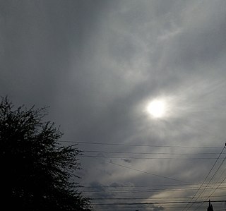
Stratocumulus Translucidus consist of separate groups of stratocumulus clouds, with a clear sky (or higher clouds) visible between them. No precipitation in most cases.[8]
Pattern-based varieties
Stratocumulus Undulatus clouds appear as nearly parallel waves, rolls or separate elongated clouds, without significant vertical development.[8]
Stratocumulus Radiatus clouds appear as the same as stratocumulus undulatus, but stratocumulus undulatus move perpendicular to the wind shear, while stratocumulus radiatus move parallel to the wind shear.
Stratocumulus Duplicatus clouds appear as stratocumulus clouds with two or more layers or sheets. Stratocumulus duplicatus is common on species lenticularis or lenticular cloud.
Stratocumulus Lacunosus clouds are very uncommon. They only occur when there are localized downdrafts striking through the stratocumuliform cloud.
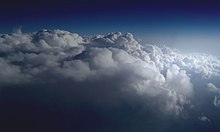
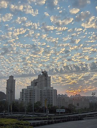
Stratocumulus undulatus clouds, seen from an airplane
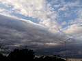
Stratocumulus undulatus asperitas clouds, seen from Earth
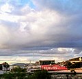
Stratocumulus radiatus
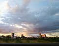
Stratocumulus duplicatus; Stratocumulus stratiformis (right) and Stratocumulus floccus (left)
Stratocumulus Asperitas is a rare, newly recognized supplementary feature that presents itself as chaotic, wavy undulations appearing in the base of a stratocumulus cloud cover. It is thought these clouds are formed by severe wind shear.
Stratocumulus Fluctus is also a rare, newly recognized supplementary feature in which short-lived "sea waves" form on top of a stratocumulus cloud, they are caused by wind speed and direction differences directly under and over the cloud.
Precipitation-based supplementary features
Stratocumulus Virga is a form of precipitation that evaporates in mid-air and doesn't reach the ground.
Stratocumulus Praecipitatio is a form of precipitation that reaches the ground as light rain or snow.
Stratocumulus Cumulomutatus the specific type of stratocumulus clouds, are flat and elongated. They form in the evening, when updrafts caused by convection decrease making cumulus clouds lose vertical development and spread horizontally. They also can occur under altostratus cloud preceding a warm or occluded front, when cumulus usually lose vertical development as the sun's heat decreases. Like all other forms of stratocumulus apart from castellanus, they are also often found in anticyclones.
Stratocumulus Cumulogenitus out of cumulus or cumulonimbus clouds, disrupted by decreasing convection. During formation period, puffy tops of cumulus clouds can protrude from stratocumulus cumulogenitus for a relatively long time until they completely spread in horizontal direction. Stratocumulus cumulogenitus appear as lengthy sheet or as group of separate elongated cloud rolls or waves.
In 2019, a study employed a large eddy simulation model to estimate that equatorial stratocumulus clouds could break up and scatter when CO2 levels rise above 1,200 ppm (almost three times higher than the current levels, and over 4 times greater than the preindustrial levels). The study estimated that this would cause a surface warming of about 8°C (14°F) globally and 10°C (18°F) in the subtropics, which would be in addition to at least 4°C (7.2°F) already caused by such CO2 concentrations. In addition, stratocumulus clouds would not reform until the CO2 concentrations drop to a much lower level.[10] It was suggested that this finding could help explain past episodes of unusually rapid warming such as Paleocene-Eocene Thermal Maximum[11] In 2020, further work from the same authors revealed that in their large eddy simulation, this tipping point cannot be stopped with solar geoengineering: in a hypothetical scenario where very high CO2 emissions continue for a long time but are offset with extensive solar geoengineering, the break-up of stratocumulus clouds is simply delayed until CO2 concentrations hit 1,700 ppm, at which point it would still cause around 5°C (9.0°F) of unavoidable warming.[12]
However, because large eddy simulation models are simpler and smaller-scale than the general circulation models used for climate projections, with limited representation of atmospheric processes like subsidence, this finding is currently considered speculative.[13] Other scientists say that the model used in that study unrealistically extrapolates the behavior of small cloud areas onto all cloud decks, and that it is incapable of simulating anything other than a rapid transition, with some comparing it to "a knob with two settings".[14] Additionally, CO2 concentrations would only reach 1,200 ppm if the world follows Representative Concentration Pathway 8.5, which represents the highest possible greenhouse gas emission scenario and involves a massive expansion of coal infrastructure. In that case, 1,200 ppm would be passed shortly after 2100.[13]
Cirrus is a genus of high cloud made of ice crystals. Cirrus clouds typically appear delicate and wispy with white strands. Cirrus are usually formed when warm, dry air rises, causing water vapor deposition onto rocky or metallic dust particles at high altitudes. Globally, they form anywhere between 4,000 and 20,000 meters above sea level, with the higher elevations usually in the tropics and the lower elevations in more polar regions.
In meteorology, a cloud is an aerosol consisting of a visible mass of miniature liquid droplets, frozen crystals, or other particles suspended in the atmosphere of a planetary body or similar space. Water or various other chemicals may compose the droplets and crystals. On Earth, clouds are formed as a result of saturation of the air when it is cooled to its dew point, or when it gains sufficient moisture from an adjacent source to raise the dew point to the ambient temperature.
Cumulonimbus is a dense, towering vertical cloud, typically forming from water vapor condensing in the lower troposphere that builds upward carried by powerful buoyant air currents. Above the lower portions of the cumulonimbus the water vapor becomes ice crystals, such as snow and graupel, the interaction of which can lead to hail and to lightning formation, respectively. When occurring as a thunderstorm these clouds may be referred to as thunderheads. Cumulonimbus can form alone, in clusters, or along squall lines. These clouds are capable of producing lightning and other dangerous severe weather, such as tornadoes, hazardous winds, and large hailstones. Cumulonimbus progress from overdeveloped cumulus congestus clouds and may further develop as part of a supercell. Cumulonimbus is abbreviated Cb.
Cumulus clouds are clouds that have flat bases and are often described as puffy, cotton-like, or fluffy in appearance. Their name derives from the Latin cumulus, meaning "heap" or "pile". Cumulus clouds are low-level clouds, generally less than 2,000 m (6,600 ft) in altitude unless they are the more vertical cumulus congestus form. Cumulus clouds may appear by themselves, in lines, or in clusters.
Altocumulus is a middle-altitude cloud genus that belongs mainly to the stratocumuliform physical category characterized by globular masses or rolls in layers or patches, the individual elements being larger and darker than those of cirrocumulus and smaller than those of stratocumulus. However, if the layers become tufted in appearance due to increased airmass instability, then the altocumulus clouds become more purely cumuliform in structure. Like other cumuliform and stratocumuliform clouds, altocumulus signifies convection. A sheet of partially conjoined altocumulus perlucidus is sometimes found preceding a weakening warm front, where the altostratus is starting to fragment, resulting in patches of altocumulus perlucidus between the areas of altostratus. Altocumulus is also commonly found between the warm and cold fronts in a depression, although this is often hidden by lower clouds.
Altostratus is a middle-altitude cloud genus made up of water droplets, ice crystals, or a mixture of the two. Altostratus clouds are formed when large masses of warm, moist air rise, causing water vapor to condense. Altostratus clouds are usually gray or blueish featureless sheets, although some variants have wavy or banded bases. The sun can be seen through thinner altostratus clouds, but thicker layers can be quite opaque.
A nimbostratus cloud is a multilevel, amorphous, nearly uniform, and often dark-grey cloud that usually produces continuous rain, snow, or sleet, but no lightning or thunder.
Cirrocumulus is one of the three main genus types of high-altitude tropospheric clouds, the other two being cirrus and cirrostratus. They usually occur at an altitude of 5 to 12 km. Like lower-altitude cumuliform and stratocumuliform clouds, cirrocumulus signifies convection. Unlike other high-altitude tropospheric clouds like cirrus and cirrostratus, cirrocumulus includes a small amount of liquid water droplets, although these are in a supercooled state. Ice crystals are the predominant component, and typically, the ice crystals cause the supercooled water drops in the cloud to rapidly freeze, transforming the cirrocumulus into cirrostratus. This process can also produce precipitation in the form of a virga consisting of ice or snow. Thus, cirrocumulus clouds are usually short-lived. They usually only form as part of a short-lived transitional phase within an area of cirrus clouds and can also form briefly as a result of the breaking up of part of a cumulonimbus anvil.
Cirrostratus is a high-altitude, very thin, generally uniform stratiform genus-type of cloud. It is made out of ice-crystals, which are pieces of frozen water. It is difficult to detect and it can make halos. These are made when the cloud takes the form of thin cirrostratus nebulosus. The cloud has a fibrous texture with no halos if it is thicker cirrostratus fibratus. On the approach of a frontal system, the cirrostratus often begins as nebulous and turns to fibratus. If the cirrostratus begins as fragmented of clouds in the sky it often means the front is weak. Cirrostratus is usually located above 5.5 km (18,000 ft). Its presence indicates a large amount of moisture in the upper troposphere. Clouds resembling cirrostratus occasionally form in polar regions of the lower stratosphere. Polar stratospheric clouds can take on this appearance when composed of tiny supercooled droplets of water or nitric acid.
Stratus clouds are low-level clouds characterized by horizontal layering with a uniform base, as opposed to convective or cumuliform clouds formed by rising thermals. The term stratus describes flat, hazy, featureless clouds at low altitudes varying in color from dark gray to nearly white. The word stratus comes from the Latin prefix strato-, meaning "layer". Stratus clouds may produce a light drizzle or a small amount of snow. These clouds are essentially above-ground fog formed either through the lifting of morning fog or through cold air moving at low altitudes. Some call these clouds "high fog" for their fog-like form.
A warm front is a density discontinuity located at the leading edge of a homogeneous warm air mass, and is typically located on the equator-facing edge of an isotherm gradient. Warm fronts lie within broader troughs of low pressure than cold fronts, and move more slowly than the cold fronts which usually follow because cold air is denser and less easy to remove from the Earth's surface. This also forces temperature differences across warm fronts to be broader in scale. Clouds ahead of the warm front are mostly stratiform, and rainfall generally increases as the front approaches. Fog can also occur preceding a warm frontal passage. Clearing and warming is usually rapid after frontal passage. If the warm air mass is unstable, thunderstorms may be embedded among the stratiform clouds ahead of the front, and after frontal passage thundershowers may continue. On weather maps, the surface location of a warm front is marked with a red line of semicircles pointing in the direction of travel.
In meteorology, Altocumulus castellanus or Altocumulus castellatus (ACCAS) is a cloud type named for its tower-like projections that billow upwards from the base of the cloud. The base of the cloud can form as low as 2,000 metres, or as high as 6,000 metres. They are very similar to cumulus congestus clouds, but at a higher level and with the cloud heaps joined at the base.
Cumulus mediocris is a low to middle level cloud with some vertical extent of the genus cumulus, larger in vertical development than Cumulus humilis. It also may exhibit small protuberances from the top and may show the cauliflower form characteristic of cumulus clouds. Cumulus mediocris clouds do not generally produce precipitation of more than very light intensity, but can further advance into clouds such as Cumulus congestus or Cumulonimbus, which do produce precipitation and severe storms.
Cumulus congestus clouds, also known as towering cumulus, are a form of cumulus that can be based in the low or middle height ranges. They achieve considerable vertical development in areas of deep, moist convection. They are an intermediate stage between cumulus mediocris and cumulonimbus, sometimes producing showers of snow, rain, or ice pellets. Precipitation that evaporates before reaching the surface is virga.
The altocumulus undulatus is a mid-level cloud, usually white or grey with layers or patches containing undulations that resemble "waves" or "ripples" in water. Elements within the cloud are generally darker than those in cirrocumulus and smaller than those in stratocumulus. These clouds may appear both as patches or as covering the sky. The width of these clouds is generally less than 300 feet thick. The presence of altocumulus undulatus may indicate precipitation within the next 20 hours or simply an overcast day.
A cloud étage is a meteorological term used to delimit any one of three main altitude levels in the troposphere where certain cloud types usually form. The term is derived from the French word which means floor or storey, as in the floor of a multi-storey building. With the exception of the low étage, the altitude range of each level varies according to latitude from Earth's equator to the arctic and antarctic regions at the poles.
A castellanus is a cloud that displays at least in its upper part cumuliform protuberances having the shape of turrets that give a crenellated aspect. Some of these turrets are higher than they are wide; they have a common base and seem to be arranged in a line. The castellanus characteristic is particularly obvious when the clouds are observed from the side.
Stratocumulus castellanus or Stratocumulus castellatus is a type of stratocumulus cloud, castellanus is derived from Latin, meaning 'of a castle' This type of cloud appears as cumuliform turrets vertically rising from a common horizontal cloud base, these turrets are taller than they are wide
Translucidus is a cloud variety. It appears in altocumulus, altostratus, stratus, and stratocumulus clouds. The cloud variety is very recognizable, with its defining feature being that it is translucent, and that it gives away the location of the Sun and Moon. Sometimes, it lets stars in the night sky be visible. It is the opposite of the cloud variety opacus, which isn't translucent, but opaque.
This page is based on this Wikipedia article Text is available under the CC BY-SA 4.0 license; additional terms may apply. Images, videos and audio are available under their respective licenses.