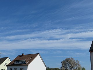
Cirrus is a genus of high cloud made of ice crystals. Cirrus clouds typically appear delicate and wispy with white strands. Cirrus are usually formed when warm, dry air rises, causing water vapor deposition onto rocky or metallic dust particles at high altitudes. Globally, they form anywhere between 4,000 and 20,000 meters above sea level, with the higher elevations usually in the tropics and the lower elevations in more polar regions.

In meteorology, a cloud is an aerosol consisting of a visible mass of miniature liquid droplets, frozen crystals, or other particles suspended in the atmosphere of a planetary body or similar space. Water or various other chemicals may compose the droplets and crystals. On Earth, clouds are formed as a result of saturation of the air when it is cooled to its dew point, or when it gains sufficient moisture from an adjacent source to raise the dew point to the ambient temperature.

Cumulus clouds are clouds which have flat bases and are often described as "puffy", "cotton-like" or "fluffy" in appearance. Their name derives from the Latin cumulo-, meaning heap or pile. Cumulus clouds are low-level clouds, generally less than 2,000 m (6,600 ft) in altitude unless they are the more vertical cumulus congestus form. Cumulus clouds may appear by themselves, in lines, or in clusters.

Altocumulus is a middle-altitude cloud genus that belongs mainly to the stratocumuliform physical category characterized by globular masses or rolls in layers or patches, the individual elements being larger and darker than those of cirrocumulus and smaller than those of stratocumulus. However, if the layers become tufted in appearance due to increased airmass instability, then the altocumulus clouds become more purely cumuliform in structure. Like other cumuliform and stratocumuliform clouds, altocumulus signifies convection. A sheet of partially conjoined altocumulus perlucidus is sometimes found preceding a weakening warm front, where the altostratus is starting to fragment, resulting in patches of altocumulus perlucidus between the areas of altostratus. Altocumulus is also commonly found between the warm and cold fronts in a depression, although this is often hidden by lower clouds.

Altostratus is a middle-altitude cloud genus made up of water droplets, ice crystals, or a mixture of the two. Altostratus clouds are formed when large masses of warm, moist air rise, causing water vapor to condense. Altostratus clouds are usually gray or blueish featureless sheets, although some variants have wavy or banded bases. The sun can be seen through thinner altostratus clouds, but thicker layers can be quite opaque.

A stratocumulus cloud, occasionally called a cumulostratus, belongs to a genus-type of clouds characterized by large dark, rounded masses, usually in groups, lines, or waves, the individual elements being larger than those in altocumulus, and the whole being at a lower height, usually below 2,000 metres (6,600 ft). Weak convective currents create shallow cloud layers because of drier, stable air above preventing continued vertical development. Historically, in English, this type of cloud has been referred to as a twain cloud for being a combination of two types of clouds.

A nimbostratus cloud is a multi-level, amorphous, nearly uniform and often dark grey cloud that usually produces continuous rain, snow or sleet but no lightning or thunder.

Cirrostratus is a high-level, very thin, generally uniform stratiform genus-type of cloud. It is made out of ice-crystals, which are pieces of frozen water. It is difficult to detect and it can make halos. These are made when the cloud takes the form of thin cirrostratus nebulosus. The cloud has a fibrous texture with no halos if it is thicker cirrostratus fibratus. On the approach of a frontal system, the cirrostratus often begins as nebulous and turns to fibratus. If the cirrostratus begins as fragmented of clouds in the sky it often means the front is weak. Cirrostratus is usually located above 5.5 km (18,000 ft). Its presence indicates a large amount of moisture in the upper troposphere. Clouds resembling cirrostratus occasionally form in polar regions of the lower stratosphere. Polar stratospheric clouds can take on this appearance when composed of tiny supercooled droplets of water or nitric acid.
Stratus clouds are low-level clouds characterized by horizontal layering with a uniform base, as opposed to convective or cumuliform clouds that are formed by rising thermals. More specifically, the term stratus is used to describe flat, hazy, featureless clouds at low altitudes varying in color from dark gray to nearly white. The word stratus comes from the Latin prefix strato-, meaning "layer". Stratus clouds may produce a light drizzle or a small amount of snow. These clouds are essentially above-ground fog formed either through the lifting of morning fog or through cold air moving at low altitudes over a region. Some call these clouds "high fog" for their fog-like form. While light rain may fall, this cloud does not indicate much meteorological precipitation.

Luke Howard, was a British manufacturing chemist and an amateur meteorologist with broad interests in science. His lasting contribution to science is a nomenclature system for clouds, which he proposed in an 1802 presentation to the Askesian Society. Because of this, Howard is referred to as "The Godfather of Clouds", the "namer of the clouds", and the "father of meteorology".

Cumulus mediocris is a low to middle level cloud with some vertical extent of the genus cumulus, larger in vertical development than Cumulus humilis. It also may exhibit small protuberances from the top and may show the cauliflower form characteristic of cumulus clouds. Cumulus mediocris clouds do not generally produce precipitation of more than very light intensity, but can further advance into clouds such as Cumulus congestus or Cumulonimbus, which do produce precipitation and severe storms.

Drizzle is a light precipitation consisting of liquid water drops smaller than those of rain – generally smaller than 0.5 mm (0.02 in) in diameter. Drizzle is normally produced by low stratiform clouds and stratocumulus clouds. Precipitation rates from drizzle are on the order of a millimetre (0.04 in) per day or less at the ground. Owing to the small size of drizzle drops, under many circumstances drizzle largely evaporates before reaching the surface and so may be undetected by observers on the ground. The METAR code for drizzle is DZ and for freezing drizzle is FZDZ.

An arcus cloud is a low, horizontal cloud formation, usually appearing as an accessory cloud to a cumulonimbus. Roll clouds and shelf clouds are the two main types of arcus clouds. They most frequently form along the leading edge or gust fronts of thunderstorms; some of the most dramatic arcus formations mark the gust fronts of derecho-producing convective systems. Roll clouds may also arise in the absence of thunderstorms, forming along the shallow cold air currents of some sea breeze boundaries and cold fronts.
Richard Hamblyn is a British environmental writer and historian. He is a lecturer in the Department of English, Theatre and Creative Writing at Birkbeck, University of London, and has contributed articles and reviews to the Sunday Times, The Guardian, the Independent, the Times Literary Supplement and the London Review of Books.

A castellanus is a cloud that displays at least in its upper part cumuliform protuberances having the shape of turrets that give a crenellated aspect. Some of these turrets are higher than they are wide; they have a common base and seem to be arranged in a line. The castellanus characteristic is particularly obvious when the clouds are observed from the side.

Stratocumulus castellanus or Stratocumulus castellatus is a type of stratocumulus cloud, castellanus is derived from Latin, meaning 'of a castle' This type of cloud appears as cumuliform turrets vertically rising from a common horizontal cloud base, these turrets are taller than they are wide

Altocumulus volutus is a type of altocumulus cloud. This cloud type has the appearance of a single, small, horizontal, rolling line, it is relatively rare compared with its counterpart stratocumulus volutus, This cloud does not attach to any other cloud. It may or may not appear with altocumulus clouds of different species. When found in a thunderstorm, it forms when cold air from a thunderstorm's downdraft makes the already present warm and moist air rise, expanding and cooling as it rises. It then condenses, although the most likely scenario is that it condenses into a shelf cloud or roll cloud, rather than an altocumulus volutus cloud. When found in environments where it is not associated with a thunderstorm, it forms because of wind shear.

Perlucidus is a cloud variety that generally appears in only two cloud types, with those cloud types being altocumulus and stratocumulus, this cloud variety is easily recognizable, with its appearance being small gaps showing up in one of the cloud types that it shows up in, which let higher clouds be seen This cloud variety forms when shallow convection starts in a cloud layer that did not previously have perlucidus variety characteristics, the gaps that make the sky visible in these clouds indicate regions where air is sinking, this cloud variety may appear either as a translucent cloud or an opaque cloud

Stratocumulus lenticularis is an uncommon cloud type that belongs to the stratocumulus cloud type, its appearance is that of a flat lens or almond. It forms as a result of gravity waves caused by wind passing over obstacles; for example, a mountain or a building. They are more common in locations that are hilly, or places where foehn winds are common They tend to look more well-defined when a foehn wind is causing their formation. They also sometimes show iridescence. It is a type of lenticular cloud.
