Strawberry Creek

Last updated
Strawberry Creek
StrawberryCreek11.JPG
Location
Country United States
State California
Region Alameda County
City Berkeley
Physical characteristics
Source Berkeley Hills
  location Oakland
  coordinates 37°52′51″N122°13′54″W / 37.88083°N 122.23167°W / 37.88083; -122.23167 [1]
Mouth San Francisco Bay

Strawberry Creek is the principal watercourse running through the city of Berkeley, California. Two forks rise in the Berkeley Hills of the California Coast Ranges, and form a confluence at the campus of the University of California, Berkeley. The creek then flows westward across the city to discharge into San Francisco Bay.

Contents

The north fork has also been called "Blackberry Creek", [2] a name which has also been applied to another small creek in Berkeley, a portion of which has been daylighted through Thousand Oaks School Park. The canyon in which the north fork of Strawberry Creek runs is called "Blackberry Canyon".

Strawberry Creek serves as a significant marker for the movement of the Hayward Fault. The creek is offset at the mouth of Strawberry Canyon, precisely at the locus of California Memorial Stadium. The filled-in middle forks located in the middle of the UC campus are thought to represent remnants of the former course of the south (main) fork of the creek, which have moved northward by fault action.

History

StrawberryCreek13.JPG

Strawberry Creek was the first surface water source for the University and parts of the city of Berkeley. A reservoir was constructed in the late 19th century in Strawberry Canyon, above the site of California Memorial Stadium. The reservoir became obsolete in the early 20th century by construction of the East Bay Municipal Utility District water system. Construction of the stadium removed a waterfall and culverted the creek in that area.

In the latter half of the 19th century, a road bridge and a railroad trestle both spanned Strawberry Creek in the downtown section at what is now the intersection of Shattuck Avenue and Allston Way. These were torn down and replaced by culverts in April–May 1893. In the process, a small grove of large and ancient oaks in the same locale was cut down.

Skeletons of Native Americans have been un-earthed along the banks of Strawberry Creek. [3]

The creek has been culverted over the years in several other locations, notably in public-works projects during the Great Depression of the 1930s, but has remained open through most of the UC campus, except in the central glade where the two small middle forks were long ago filled in. The south fork of Strawberry Creek has some riparian coast redwood groves on the university campus and is also suitable habitat for the California slender salamander and arboreal salamander. [4]

Water pollution due to urbanization in the beginning of the twentieth century has degraded the environmental quality of the creek. In 1987, a program dedicated to improving water quality and reintroducing native species was a success. The condition of Strawberry Creek was restored to satisfaction in 1991. Since then, environmental education and restoration programs continues to monitor the quality of the creek. [5]

Reintroduction of native organisms

Fish

Strawberry Creek used to have around 13 native fish species, including coldwater salmonids, anadromous steelhead and coho salmon. However, observing fish was difficult due to pollution, a decrease in fish population, and poor water quality. Therefore, historical trend data was not available, so the reintroduction data was majorly based on recent studies. Since then, five species have been reintroduced to the creek: three spined stickleback (Gasterosteus aculeatus), California roach (Lavinias symmetricus), California Hitch (Lavinia exilicauda), Sacramento sucker (Catostomus occidentalis), and the prickly sculpin (Cottus asper). [6]

The attempts to reintroduce native fish were not successful. First, the water quality of the creek was not good enough for fish to inhabit. Water quality tests confirmed the water contained a disturbing amount of mercury and coliform, which was dangerous for not only humans, but also animals that contact with the water. [7] The sanitary issues were partly caused by improper disposal of garbage and poorly engineered drain system. Secondly, high flow rates, and more importantly, great difference in flow rates is a great concern for the reintroduction of fish. High flow rates can be up to 118 times faster than the regular flow rates at the same location. High flow rates were caused by the construction of dams along the creek. [7] Reintroduced fish were not able to inhabit under such circumstances. [8] Finally, the introduction of a non-native fish, Pacifastacus leniusculus, or Crayfish has a negative impact on the native fish population. Crayfish is more aggressive than the native fish species in predation, therefore, has a potential to threaten local fish abundance. [9]

Plants

Ivy dominating Strawberry Creek. StrawberryCreek5.JPG
Ivy dominating Strawberry Creek.

Since urbanization, new species were introduced to Strawberry creek. The invasion of exotic plants has endangered the existence of local seedlings. Low biomass of native seedlings is caused by the competition of water in the soil. Exotic species have different rates of growth and evapotranspiration, which changes the soil moisture of the creek. For example, Algerian ivy and English Ivy have taken over the native habitat. They required minimum management and were capable of absorbing pollution, therefore, they were able to spread quickly and dominate the creek area. Ivy has decreased the soil moisture, which even harder for native species to survive. [10]

Daylighting proposals

Efforts to re-open or daylight the creek throughout its natural course through Berkeley continue, and have so far resulted in the establishment of "Strawberry Creek Park" [11] in West Berkeley on the site of what used to be a small freight yard of the Santa Fe Railway. The creek is also open through several private yards in the blocks east of the park, starting just below (west of) Sacramento Street.

In 2010, momentum grew behind a plan to divert water from Strawberry Creek to the surface alongside Center Street. This proposal, backed largely by Ecocity Builders' Richard Register, would not restore the creek's original riparian habitat or path (which lies one block south along Allston Way). Instead, it would incorporate representational elements of the stream into a pedestrian plaza. [12]

Mouth

At the mouth of Strawberry Creek where it enters San Francisco Bay, the local indigenous people built up a shellmound. Until the end of the 1700s, the Ohlone indigenous people would eat shellfish provided by the creek and pile the empty shells into a mound, signifying a sacred burial site. [13] There was also a small wood of native willows here which was used in the late 19th century as a park. Jacobs' Landing, established early during the California Gold Rush, was the nucleus around which the Ocean View settlement that predated Berkeley was founded. The creek now enters San Francisco Bay from a rectangular concrete culvert mouth, south of University Avenue and west of the I-80/580 freeway, behind Sea Breeze Market and Deli. This area is now part of Eastshore State Park, managed by the East Bay Regional Park District. The tide flats at the creek mouth are important shorebird habitats, popular with bird watchers. Friends of Five Creeks, [14] a volunteer group, has worked since 2000 to control invasives and re-establish some native vegetation here.

Land use

UC Berkeley has developed the upper Strawberry Creek watershed. The university's central campus, including parking lots, green spaces, roadways, and Lawrence Berkeley Labs were built in this area. In addition, recreational structures such as Kleeberger Field, Memorial Stadium, and the Hats Recreation Area were constructed in the area. The total urbanized areas in the watershed comprised about 37% of the total area. [15]

Strawberry Creek, Berkeley, by Edwin Deakin Strawberry Creek, Berkeley.JPG
Strawberry Creek, Berkeley, by Edwin Deakin

See also

Related Research Articles

<span class="mw-page-title-main">Merced River</span> River in California

The Merced River, in the central part of the U.S. state of California, is a 145-mile (233 km)-long tributary of the San Joaquin River flowing from the Sierra Nevada into the San Joaquin Valley. It is most well known for its swift and steep course through the southern part of Yosemite National Park, where it is the primary watercourse flowing through Yosemite Valley. The river's character changes dramatically once it reaches the plains of the agricultural San Joaquin Valley, where it becomes a slow-moving meandering stream.

<span class="mw-page-title-main">Eel River (California)</span> River in northern California, United States

The Eel River is a major river, about 196 miles (315 km) long, in northwestern California. The river and its tributaries form the third largest watershed entirely in California, draining a rugged area of 3,684 square miles (9,540 km2) in five counties. The river flows generally northward through the Coast Ranges west of the Sacramento Valley, emptying into the Pacific Ocean about 10 miles (16 km) downstream from Fortuna and just south of Humboldt Bay. The river provides groundwater recharge, recreation, and industrial, agricultural and municipal water supply.

<span class="mw-page-title-main">Temescal Creek (Northern California)</span> River in California, United States

Temescal Creek is one of the principal watercourses in the city of Oakland, California, United States.

<span class="mw-page-title-main">Malibu Creek</span> River in the southern California

Malibu Creek is a year-round stream in western Los Angeles County, California. It drains the southern Conejo Valley and Simi Hills, flowing south through the Santa Monica Mountains, and enters Santa Monica Bay in Malibu, California. The Malibu Creek watershed drains 109 square miles (280 km2) and its tributary creeks reach as high as 3,000 feet (910 m) into Ventura County, California. The creek's mainstem begins south of Westlake Village at the confluence of Triunfo Creek and Lobo Canyon Creek, and flows 13.4 miles (21.6 km) to Malibu Lagoon.

<span class="mw-page-title-main">Cache Creek (Sacramento River tributary)</span> Stream from Lake to Yolo Counties, CA

Cache Creek is an 87-mile-long (140 km) stream in Lake, Colusa and Yolo counties, California.

<span class="mw-page-title-main">Big River (California)</span> River in Mendocino County, California (USA), south of Mendocino Village

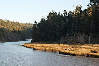
The Big River is a 41.7-mile-long (67.1 km) river in Mendocino County, California, that flows from the northern California Coast Range to the Pacific Ocean at Mendocino, Mendocino County, California. From the mouth, brackish waters extend 8 miles (13 km) upstream, forming the longest undeveloped estuary in the state.

<span class="mw-page-title-main">Alameda Creek</span> River in California, United States

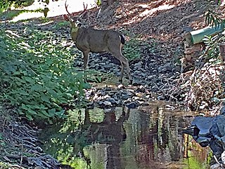
Alameda Creek is a large perennial stream in the San Francisco Bay Area. The creek runs for 45 miles (72 km) from a lake northeast of Packard Ridge to the eastern shore of San Francisco Bay by way of Niles Canyon and a flood control channel. Along its course, Alameda Creek provides wildlife habitat, water supply, a conduit for flood waters, opportunities for recreation, and a host of aesthetic and environmental values. The creek and three major reservoirs in the watershed are used as water supply by the San Francisco Public Utilities Commission, Alameda County Water District and Zone 7 Water Agency. Within the watershed can be found some of the highest peaks and tallest waterfall in the East Bay, over a dozen regional parks, and notable natural landmarks such as the cascades at Little Yosemite and the wildflower-strewn grasslands and oak savannahs of the Sunol Regional Wilderness. After an absence of half a century, ocean-run steelhead trout are able to return to Alameda Creek to mingle with remnant rainbow trout populations. Completion of a series of dam removal and fish passage projects, along with improved stream flows for cold-water fish and planned habitat restoration, enable steelhead trout and Chinook salmon to access up to 20 miles (32 km) of spawning and rearing habitat in Alameda Creek and its tributaries. The first juvenile trout migrating downstream from the upper watershed through lower Alameda Creek toward San Francisco Bay was detected and documented in April 2023.

<span class="mw-page-title-main">Sonoma Creek</span> Stream in California

Sonoma Creek is a 33.4-mile-long (53.8 km) stream in northern California. It is one of two principal drainages of southern Sonoma County, California, with headwaters rising in the rugged hills of Sugarloaf Ridge State Park and discharging to San Pablo Bay, the northern arm of San Francisco Bay. The watershed drained by Sonoma Creek is roughly equivalent to the wine region of Sonoma Valley, an area of about 170 square miles (440 km2). The State of California has designated the Sonoma Creek watershed as a “Critical Coastal Water Resource”. To the east of this generally rectangular watershed is the Napa River watershed, and to the west are the Petaluma River and Tolay Creek watersheds.

<span class="mw-page-title-main">Russian River (California)</span> River in California

The Russian River is a southward-flowing river that drains 1,485 sq mi (3,850 km2) of Sonoma and Mendocino counties in Northern California. With an annual average discharge of approximately 1,600,000 acre feet (2.0 km3), it is the second-largest river flowing through the nine-county Greater San Francisco Bay Area, with a mainstem 115 mi (185 km) long.

<span class="mw-page-title-main">San Francisquito Creek</span> River in California, United States

San Francisquito Creek is a creek that flows into southwest San Francisco Bay in California, United States. Historically it was called the Arroyo de San Francisco by Juan Bautista de Anza in 1776. San Francisquito Creek courses through the towns of Portola Valley and Woodside, as well as the cities of Menlo Park, Palo Alto, and East Palo Alto. The creek and its Los Trancos Creek tributary define the boundary between San Mateo and Santa Clara counties.

<span class="mw-page-title-main">Arroyo Corte Madera del Presidio</span> River in California, United States

Arroyo Corte Madera del Presidio is a 4.1-mile-long (6.6 km) year-round stream in southern Marin County, California, United States. This watercourse is also known as Corte Madera Creek, although the actual stream of that name flows into San Francisco Bay further north at Point San Quentin. This watercourse has a catchment basin of about 8 square miles (21 km2) and drains the south-eastern slopes of Mount Tamalpais and much of the area in and around the town of Mill Valley; this stream discharges to Richardson Bay.

<span class="mw-page-title-main">Pilarcitos Creek</span> River in California, United States

Pilarcitos Creek is a 13.5-mile-long (21.7 km) coastal stream in San Mateo County, California, United States, that rises on the western slopes of the Santa Cruz Mountains and descends through Pilarcitos Canyon to discharge into the Pacific Ocean Half Moon Bay State Beach.

<span class="mw-page-title-main">Tryon Creek</span> Tributary of the Willamette River in Oregon

Tryon Creek is a 4.85-mile (7.81 km) tributary of the Willamette River in the U.S. state of Oregon. Part of the drainage basin of the Columbia River, its watershed covers about 6.5 square miles (16.8 km2) in Multnomah and Clackamas counties. The stream flows southeast from the Tualatin Mountains through the Multnomah Village neighborhood of Portland and the Tryon Creek State Natural Area to the Willamette in the city of Lake Oswego. Parks and open spaces cover about 21 percent of the watershed, while single-family homes dominate most of the remainder. The largest of the parks is the state natural area, which straddles the border between the two cities and counties.

<span class="mw-page-title-main">San Gregorio Creek</span> River in California, United States

San Gregorio Creek is a river in San Mateo County, California. Its tributaries originate on the western ridges of the Santa Cruz Mountains whence it courses southwest through steep forested canyons. The San Gregorio Creek mainstem begins at the confluence of Alpine and La Honda Creeks, whence it flows 12 miles (19 km) through rolling grasslands and pasturelands until it meets the Pacific Ocean at San Gregorio State Beach. It traverses the small unincorporated communities of La Honda, San Gregorio, Redwood Terrace and Sky Londa.

<span class="mw-page-title-main">Aliso Creek (Orange County)</span> River in the United States of America

Aliso Creek is a 19.8-mile (31.9 km)-long, mostly urban stream in south Orange County, California. Originating in the Cleveland National Forest in the Santa Ana Mountains, it flows generally southwest and empties into the Pacific Ocean at Laguna Beach. The creek's watershed drains 34.9 square miles (90 km2), and it is joined by seven main tributaries. As of 2018, the watershed had a population of 144,000 divided among seven incorporated cities.

<span class="mw-page-title-main">San Diego Creek</span> River in California, United States

San Diego Creek is a 16-mile (26 km) urban waterway flowing into Upper Newport Bay in Orange County, California in the United States. Its watershed covers 112.2 square miles (291 km2) in parts of eight cities, including Irvine, Tustin, and Costa Mesa. From its headwaters in Laguna Woods the creek flows northwest to its confluence with Peters Canyon Wash, where it turns abruptly southwest towards the bay. Most of the creek has been converted to a concrete flood control channel, but it also provides important aquatic and riparian habitat along its course and its tidal estuary.

<span class="mw-page-title-main">South Fork Eel River</span> River in north-central California

The South Fork Eel River is the largest tributary of the Eel River in north-central California in the United States. The river flows 105 miles (169 km) north from Laytonville to Dyerville/Founders' Grove where it joins the Eel River. The South Fork drains a long and narrow portion of the Coast Range of California in parts of Mendocino and Humboldt counties. U.S. Route 101 follows the river for much of its length.

<span class="mw-page-title-main">Permanente Creek</span> River in California, United States

Permanente Creek is a 13.3-mile-long (21.4 km) stream originating on Black Mountain in Santa Clara County, California, United States. Named by early Spanish explorers as Arroyo Permanente or Río Permanente because of its perennial flow, the creek descends the east flank of Black Mountain then courses north through Los Altos and Mountain View, discharging into southwest San Francisco Bay historically at the Mountain View Slough but now virtually entirely diverted via the Permanente Creek Diversion Channel to Stevens Creek and Whisman Slough in San Francisco Bay.

<span class="mw-page-title-main">Marsh Creek (California)</span> River in California, United States

Marsh Creek is a stream in east Contra Costa County, California in Northern California which rises on the eastern side of Mount Diablo and flows 30 miles (48 km) to the Sacramento–San Joaquin River Delta at Oakley, California, near Big Break Regional Shoreline. The creek flows through Marsh Creek State Park (California), where water is impounded to form Marsh Creek Reservoir, then through the city of Brentwood, California.

<span class="mw-page-title-main">Cottonwood Creek (Sacramento River tributary)</span> River in Shasta County, United States

Cottonwood Creek is a major stream and tributary of the Sacramento River in Northern California. About 68 miles (109 km) long measured to its uppermost tributaries, the creek drains a large rural area bounded by the crest of the Coast Ranges, traversing the northwestern Sacramento Valley before emptying into the Sacramento River near the town of Cottonwood. It defines the boundary of Shasta and Tehama counties for its entire length. Because Cottonwood Creek is the largest undammed tributary of the Sacramento River, it is known for its Chinook salmon and steelhead runs.

References

  1. U.S. Geological Survey Geographic Names Information System: Strawberry Creek
  2. "1923 Map of East Bay Creeks and Hayward Fault" (map). University of California, Berkeley.
  3. "Mongoloid Type Skeleton is Dug Up at Berkeley". Oakland Tribune. June 20, 1925. Retrieved 4 December 2022.
  4. J.Torrey, A.Kratter et al., Environmental Impact Report for the Business Administration Building, University of California, Berkeley, Earth Metrics Incorporated, California State Clearinghouse, April, 1989
  5. Charbonneau, Robert; Resh, Vincent H. (1992). "Strawberry creek on the University of California, Berkeley campus: A case history of urban stream restoration". Aquatic Conservation: Marine and Freshwater Ecosystems. 2 (4): 293–307. doi:10.1002/aqc.3270020402. ISSN   1099-0755.
  6. "Strawberry Creek - Biology | Creeks of UC Berkeley". creeks.berkeley.edu. Retrieved 2021-11-11.
  7. 1 2 "Water quality, bed-sediment quality, and simulation of potential contaminant transport in Foster Creek, Berkeley County, South Carolina, 1991-93". 1996. doi: 10.3133/wri954247 . hdl: 2027/mdp.39015036985177 .{{cite journal}}: Cite journal requires |journal= (help)
  8. Koziol, Deb (2002-02-01). "Restoring Anadromous Fish Habitat in Big Canyon Creek Watershed; Anadromous Fish Habitat Restoration in the Nichols Canyon Subwatershed, 2001 Annual Report". doi:10.2172/890700. OSTI   890700.{{cite journal}}: Cite journal requires |journal= (help)
  9. Rahel, Frank J. (April 1989). "Nest defense and aggressive interactions between a small benthic fish (the johnny darter Etheostoma nigrum) and crayfish". Environmental Biology of Fishes. 24 (4): 301–306. doi:10.1007/bf00001404. ISSN   0378-1909. S2CID   22025028.
  10. Williams, P.L. (1995-03-01). "Features and dimensions of the Hayward Fault Zone in the Strawberry and Blackberry Creek Area, Berkeley, California". doi: 10.2172/93943 . S2CID   59474996.{{cite journal}}: Cite journal requires |journal= (help)
  11. "Strawberry Creek Park". City of Berkeley.
  12. "Bay Area Cities Rediscover the Creeks Under Their Streets". Streetsblog. 9 April 2010.
  13. Davuluri, Suthri (November 1, 2016). "Take A Stroll Through Strawberry Creek's History". Student Environmental Resource Center. Retrieved 18 February 2020.
  14. "Friends of Five Creeks". Fivecreeks.org. Retrieved 2022-02-19.
  15. "3.5 - Land Use | Creeks of UC Berkeley". creeks.berkeley.edu. Retrieved 2021-11-11.