Petaluma River

Last updated

Petaluma River
Petaluma California aerial view.jpg
The river flowing through Petaluma. View is to the southeast.
Petaluma River Watershed.jpg
Petaluma River watershed (Interactive map)
Etymology Coast Miwok
Location
Country United States
State California
Region Sonoma and Marin counties
City Petaluma, California
Physical characteristics
Source 
  location1.5 mi (2 km) southwest of Cotati, California
  coordinates 38°18′18″N122°43′3″W / 38.30500°N 122.71750°W / 38.30500; -122.71750 [1]
  elevation332 ft (101 m)
Mouth San Pablo Bay
  location
5 mi (8 km) east of Novato, California
  coordinates
38°6′38″N122°29′15″W / 38.11056°N 122.48750°W / 38.11056; -122.48750 [1]
  elevation
0 ft (0 m)
Length18 mi (29 km) [1]
Basin size370 km² (140 sq. miles)
Discharge 
  locationPetaluma (USGS gage station 11459000)
  average17 cu ft/s (0.48 m3/s)
  minimum0 cu ft/s (0 m3/s)
  maximum9,620 cu ft/s (272 m3/s)
Basin features
Tributaries 
  left Lichau Creek, Lynch Creek, Washington Creek, Adobe Creek
  right San Antonio Creek

The Petaluma River is a river in the California counties of Sonoma and Marin [1] that becomes a tidal slough for most of its length. The headwaters are in the area southwest of Cotati. The flow is generally southward through Petaluma's old town, where the waterway becomes navigable, and then flows another 10 mi (16 km) through tidal marshes before emptying into the northwest corner of San Pablo Bay.

Contents

History

The mouth of the Petaluma River. View is to the northeast. PetalumaRiverMouth.jpg
The mouth of the Petaluma River. View is to the northeast.

The word Petaluma may derive from the Miwok words pe’ta, flat, and luma, back. The Miwok people lived in Sonoma County for more than 2500 years. Petaluma was the name of a village on a low hill east of Petaluma creek and north east of the present day town of Petaluma. The first recorded exploration of the Petaluma River was by Captain Fernando Quiros in October, 1776. While other members of his Spanish expedition collected adobe and timber for the new Presidio of San Francisco and for the Mission San Francisco de Asís (Mission Dolores), Quiros and his sailors tried unsuccessfully to sail from San Pablo Bay to Bodega Bay. [2]

Petaluma River Watershed

Located in southern Sonoma County, California, and a portion of northeastern Marin, the Petaluma River Watershed drains 146 square miles (380 km2). [3] The watershed is approximately 19 miles (31 km) long and 13 miles (21 km) wide with the City of Petaluma near its center. At 2,295 feet (700 m), Sonoma Mountain is the highest point in the watershed, and its western slopes drain to the Petaluma River by way of tributaries such as Lichau Creek, Lynch Creek, Washington Creek, and Adobe Creek. The lower 12 miles (19 km) of the Petaluma River flow through the Petaluma Marsh, the largest remaining salt marsh in San Pablo Bay. The marsh covers 5,000 acres (20 km2) and is surrounded by approximately 7,000 acres (28 km2) of reclaimed wetlands. [3] In the marshes west of Lakeville, the river is joined by San Antonio Creek, at which point it becomes the boundary between Marin County and Sonoma County. The river flows under State Route 37 at Green Point and enters northwest San Pablo Bay just north of Petaluma Point.

While the river's source lies over 300 ft (100 m) above sea level, it descends to 50 ft (15 m) within about 0.4 mi (600 m). The river is fully tidal 11 mi (18 km) from its mouth, indicating its slight gradient through the marshes below Petaluma. The United States Army Corps of Engineers dredges this section to keep it navigable by gravel barges and pleasure craft.

Ecology

Petaluma River Watershed 2007 Steelhead Trout Biosurvey Petaluma River Watershed 2007 Steelhead Survey.jpg
Petaluma River Watershed 2007 Steelhead Trout Biosurvey

The Petaluma River Watershed hosts several federally endangered animals including the salt marsh harvest mouse (Reithrodontomys raviventris), the North American river otter (Lontra canadensis), and Ridgway's rail (Rallus obsoletus). Endangered flora include soft bird’s-beak (Cordylanthus mollis ssp. mollis), Baker’s stickyseed ( Blennosperma bakeri ), Burke’s goldfields ( Lasthenia burkei ), showy Indian clover (Trifolium amoenum), and Sebastopol meadowfoam (Limnanthes vinculans). [3]

Steelhead (Oncorhyncus mykiss) that spawn and rear in the Petaluma River watershed are wild, not hatchery, stock. [4] Chinook salmon (Oncorhynchus tshawytscha) are seen in the main stem of the Petaluma River and The United Anglers of Casa Grande High School have seen chinook at the turning basin, near the Lynch Creek confluence. The high school students constructed a salmonid hatchery in 1993 [5] and in 2002 74 Chinook salmon returned to spawn in the Adobe Creek tributary. [6]

Habitat and pollution

The Petaluma River Floodplain, west of Lakeville PetalumaRiverFloodplain.jpg
The Petaluma River Floodplain, west of Lakeville

The marshes provide an important wildlife habitat and fish hatchery. However, since the onset of intensive immigration in the mid-1850s, the water quality has diminished, partly due to overgrazing and other agricultural uses. Pollutants present in the river include nitrates, phosphates, petroleum hydrocarbons, pesticides and sediment. [7] Urban runoff, particularly from the City of Petaluma, adds heavy metals and hydrocarbons to the river. [8] Starting about 1990, material steps were taken to mitigate the pollution.

Because the Petaluma River is relatively well-protected, most of the pollution comes from nearby storm drains. It is up to the people of Petaluma to keep the river clean.

Because most of the length of the waterway is tidal and urban/suburban, there is a significant collection of tidally deposited debris along the banks. Despite the poor aesthetics including turbidity, the water quality is not particularly poor. [9]

It has been alleged that the greatest threat to the Petaluma River is the planned Dutra asphalt plant. The reported concerns involve the "loud noises it will create" that will scare away the birds and "throw off the entire ecosystem". [10]

Bridges

The following bridges span the Petaluma River moving upstream from San Pablo Bay through Petaluma: the Black Point Railroad Bridge (NWP), California State Route 37, Haystack Landing Bridge (NWP), U.S. 101, D Street, Washington Street, Lakeville Street, NWP, Payran Street, NWP, Oak Drive, Corona Road, Petaluma Boulevard North, and Rainsville Road. [11] The longest highway span, the 4-lane Route 37 bridge, is 2,183 ft (665 m) long and was built in 1958. The oldest public bridge, built in 1925, is a 114 ft (35 m) concrete triple span carrying two lanes of Petaluma Boulevard North. [12]

Removal and replacement of the U.S. Route 101 highway bridge over the river began in 2013. The existing bridge was an 866 feet long, twin reinforced concrete box girder bridge (with a pre-cast I girder span over the river) that was built in 1955. It had two lanes of traffic in each direction, limited sight lines, and no shoulders. The new bridge is a 907 feet long, precast, post-tensioned spliced concrete girder design with three lanes of traffic in each direction and standard shoulders. [13] Construction completed in mid-2016. [14]

See also

Related Research Articles

<span class="mw-page-title-main">Sonoma County, California</span> County in California, United States

Sonoma County is located in the U.S. state of California. As of the 2020 United States Census, its population was 488,863. Its seat of government and largest city is Santa Rosa.

<span class="mw-page-title-main">Coast Miwok</span> Tribe of Native American people

The Coast Miwok are an Indigenous people of California that were the second-largest tribe of the Miwok people. Coast Miwok inhabited the general area of modern Marin County and southern Sonoma County in Northern California, from the Golden Gate north to Duncans Point and eastward to Sonoma Creek. Coast Miwok included the Bodega Bay Miwok, or Olamentko (Olamentke), from authenticated Miwok villages around Bodega Bay, the Marin Miwok, or Hookooeko (Huukuiko), and Southern Sonoma Miwok, or Lekahtewutko (Lekatuit). While they did not have an overarching name for themselves, the Coast Miwok word for people, Micha-ko, was suggested by A. L. Kroeber as a possible endonym, keeping with a common practice among tribal groups and the ethnographers studying them in the early 20th Century and with the term Miwok itself, which is the Central Sierra Miwok word for people.

<span class="mw-page-title-main">San Pablo Bay</span> Tidal estuary in the San Francisco Bay Area

San Pablo Bay is a tidal estuary that forms the northern extension of San Francisco Bay in the East Bay and North Bay regions of the San Francisco Bay Area in northern California.

<span class="mw-page-title-main">Guadalupe River (California)</span> River in Santa Clara County, California, United States

The Guadalupe River mainstem is an urban, northward flowing 14 miles (23 km) river in California whose much longer headwater creeks originate in the Santa Cruz Mountains. The river mainstem now begins on the Santa Clara Valley floor when Los Alamitos Creek exits Lake Almaden and joins Guadalupe Creek just downstream of Coleman Road in San Jose, California. From here it flows north through San Jose, where it receives Los Gatos Creek, a major tributary. The Guadalupe River serves as the eastern boundary of the City of Santa Clara and the western boundary of Alviso, and after coursing through San José, it empties into south San Francisco Bay at the Alviso Slough.

<span class="mw-page-title-main">Sears Point</span> Landform in Sonoma County, California

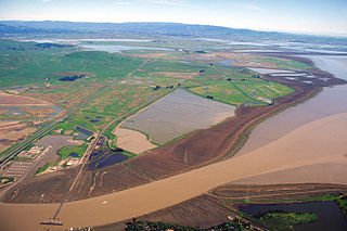
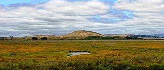
Sears Point is a prominent landform that juts into the San Pablo Bay in Sonoma County, California, United States. This hill is the southernmost peak of the Sonoma Mountains and forms the southwestern ridge above Tolay Lake. Starting with European settlement of this area in the mid-19th century considerable modification of the Napa Sonoma Marsh began to occur, such that in contemporary times, there is considerable upland between Sears Point and San Pablo Bay. Numerous local conservation organizations are presently working to restore hundreds of acres of these historic tidal wetlands as part of the Sears Point Wetlands and Watershed Restoration Project. The region can be accessed via State Route 37 or State Route 121.

<span class="mw-page-title-main">Sonoma Valley</span> Valley in the North Bay region of California famous for winemaking

Sonoma Valley is a valley located in southeastern Sonoma County, California, in the North Bay region of the San Francisco Bay Area. Known as the birthplace of the California wine industry, the valley is home to some of the earliest vineyards and wineries in the state, some of which survived the phylloxera epidemic of the 1870s and the impact of prohibition in the early 20th century. Today, the valley's wines are promoted by the U.S. federal government's Sonoma Valley and Carneros AVAs.

<span class="mw-page-title-main">Sonoma Creek</span> Stream in California

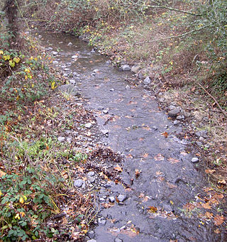
Sonoma Creek is a 33.4-mile-long (53.8 km) stream in northern California. It is one of two principal drainages of southern Sonoma County, California, with headwaters rising in the rugged hills of Sugarloaf Ridge State Park and discharging to San Pablo Bay, the northern arm of San Francisco Bay. The watershed drained by Sonoma Creek is roughly equivalent to the wine region of Sonoma Valley, an area of about 170 square miles (440 km2). The State of California has designated the Sonoma Creek watershed as a “Critical Coastal Water Resource”. To the east of this generally rectangular watershed is the Napa River watershed, and to the west are the Petaluma River and Tolay Creek watersheds.

<span class="mw-page-title-main">Sonoma Mountains</span>

The Sonoma Mountains are a northwest–southeast trending mountain range of the Inner Coast Ranges in the California Coast Ranges System, located in Sonoma County, Northern California.

<span class="mw-page-title-main">Americano Creek</span> Stream in California

Americano Creek is a 7.5-mile (12 km) long westward-flowing stream in the California counties of Sonoma and Marin. It flows into the Estero Americano, a 9.2 mi (15 km) long estuary, and thence to the Pacific Ocean. This article covers both watercourses.

<span class="mw-page-title-main">Tolay Lake</span> Lake in Sonoma County, California

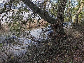
Tolay Lake is a shallow freshwater lake in southern Sonoma County, California, United States. The lake, nestled within the southern vestiges of the Sonoma Mountains, is the site of significant Native American prehistoric seasonal settlement. In 2005, Sonoma County acquired the entirety of the lake and virtually its whole drainage basin from the Cardoza family for the sum of $18 million; the county's intention is to utilize the property as Tolay Lake Regional Park for ecological and archaeological preservation, as well as public use and enjoyment. Tolay Lake and its immediate drainage area is home to several nesting pairs of golden eagles, Aquila chrysaetos, and a number of rare, threatened or endangered species including the California red-legged frog, Rana draytonii; Western pond turtle, Actinemys marmorata; and Western burrowing owl, Athene cunicularia.

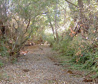
Tolay Creek is a 12.5-mile-long (20.1 km) southward-flowing stream in southern Sonoma County, California, United States, which flows through Tolay Lake and ends in north San Pablo Bay.

<span class="mw-page-title-main">Hydrography of the San Francisco Bay Area</span> Waterways and watersheds draining into the bay or Pacific Ocean

The Hydrography of the San Francisco Bay Area is a complex network of watersheds, marshes, rivers, creeks, reservoirs, and bays predominantly draining into the San Francisco Bay and Pacific Ocean.

<span class="mw-page-title-main">Nicasio Creek</span> River in California, United States

Nicasio Creek is an 11.9-mile-long (19.2 km) stream in Marin County, California, United States and is the primary tributary of Lagunitas Creek, which flows, in turn, into Tomales Bay, and the Pacific Ocean. The Nicasio Reservoir, formed in 1961 by Seeger Dam, is located on this stream.

San Antonio Creek is a northward then eastward-flowing stream in the California, United States, counties of Marin and Sonoma that forms part of the boundary between those counties. It empties into the tidal portion of the Petaluma River.

<span class="mw-page-title-main">Adobe Creek (Sonoma County, California)</span> River in California, United States

Adobe Creek is a southward-flowing stream in Sonoma County, California, United States, which flows past the historic Rancho Petaluma Adobe on the creek's 7.5-mile (12.1 km) course to its confluence with the Petaluma River. It has also been called Casa Grande Creek.

<span class="mw-page-title-main">Novato Creek</span> River in California, United States

Novato Creek is a stream in eastern Marin County, California, United States. It originates in highlands between Red Hill and Mount Burdell above the city of Novato, California, and flows 17 miles (27 km) before emptying into San Pablo Bay south of Petaluma Point.

<span class="mw-page-title-main">Lynch Creek</span> River in California, United States

Lynch Creek is a 7.1-mile-long (11.4 km) stream in Sonoma County, California, United States which discharges into the Petaluma River.

<span class="mw-page-title-main">San Pablo Bay National Wildlife Refuge</span> Protected area in California, United States

San Pablo Bay National Wildlife Refuge is a 13,190-acre (53.4 km2) National Wildlife Refuge in California established in 1970. It extends along the northern shore of San Pablo Bay, from the mouth of the Petaluma River, to Tolay Creek, Sonoma Creek, and ending at Mare Island.

<span class="mw-page-title-main">Corte Madera Creek (Marin County)</span> River in California, United States

Corte Madera Creek is a short stream which flows southeast for 4.5 miles (7.2 km) in Marin County, California. Corte Madera Creek is formed by the confluence of San Anselmo Creek and Ross Creek in Ross and entering a tidal marsh at Kentfield before connecting to San Francisco Bay near Corte Madera.

<span class="mw-page-title-main">Rush Creek (Marin County, California)</span> River in California, United States

Rush Creek is a stream in eastern Marin County, California, United States. It originates on the north edge of Novato, California and flows 1.5 miles (2.4 km) northeasterly through wetlands into Black John Slough and then the Petaluma River. The name is associated with Peter Rush who bought land near Novato in 1862.

References

  1. 1 2 3 4 U.S. Geological Survey Geographic Names Information System: Petaluma River
  2. Adair Heig (1982). History of Petaluma, A California River Town. San Francisco, California: Scottwall Associates.
  3. 1 2 3 The Southern Sonoma County Resource Conservation District (July 1999). Petaluma Watershed Enhancement Plan (Report). The State Water Resources Control Board. Retrieved June 24, 2010.
  4. Prunuske Chatham, Inc. (February 1999). Fisheries Enhancement Opportunities in the Petaluma River Watershed (PDF) (Report). Southern Sonoma County Resource Conservation District. Retrieved June 24, 2010.
  5. Malcolm MacConnell (1999). "Miracle at Adobe Creek". Reader's Digest. Archived from the original on July 5, 2010. Retrieved June 24, 2010.
  6. "Project Highlights". United Anglers of Casa Grande High School. 2001. Archived from the original on July 5, 2010. Retrieved June 24, 2010.
  7. "Petaluma River Water Quality Profile" (PDF). ca.gov. Retrieved April 10, 2018.
  8. Kay Ransom, C. Michael Hogan, Ballard George et al., Environmental Impact Report for the Petaluma General Plan, prepared by Earth Metrics Inc. for the city of Petaluma (1986)
  9. California, City of Petaluma IT Division, State of. "Petaluma". cityofpetaluma.net. Retrieved April 10, 2018.{{cite web}}: CS1 maint: multiple names: authors list (link)
  10. "Stop the New Dutra Asphalt Plant in Petaluma". nopetalumaasphaltplant.com. Retrieved April 10, 2018.
  11. Sonoma County Street Guide and Directory . Irvine, California: Thomas Brothers Maps. 1994. pp.  176, 183, 184, 191, 192, 196, 197&199. ISBN   0-88130-738-6.
  12. "National Bridge Inventory Database".
  13. "Caltrans District 4 | MSN 101 Petaluma Blvd South Interchange and Petaluma Bridge Project Interstate 116 Interchange Project". June 9, 2013. Archived from the original on June 9, 2013. Retrieved June 7, 2023.
  14. "Birders hopeful for return of swallows to Petaluma bridge". Petaluma Argus-Courier. March 25, 2016. Retrieved June 7, 2023.