A tributary, or affluent, is a stream or river that flows into a larger stream or main stem river or a lake. A tributary does not flow directly into a sea or ocean. Tributaries and the main stem river drain the surrounding drainage basin of its surface water and groundwater, leading the water out into an ocean. The Irtysh is a chief tributary of the Ob river and is also the longest tributary river in the world with a length of 4,248 km (2,640 mi). The Madeira River is the largest tributary river by volume in the world with an average discharge of 31,200 m3/s (1.1 million cu ft/s).
Orography is the study of the topographic relief of mountains, and can more broadly include hills, and any part of a region's elevated terrain. Orography falls within the broader discipline of geomorphology. The term orography comes from the Greek: όρος, hill, γραφία, to write.

A drainage basin is an area of land where all flowing surface water converges to a single point, such as a river mouth, or flows into another body of water, such as a lake or ocean. A basin is separated from adjacent basins by a perimeter, the drainage divide, made up of a succession of elevated features, such as ridges and hills. A basin may consist of smaller basins that merge at river confluences, forming a hierarchical pattern.

The headwater of a river or stream is the farthest point on each of its tributaries upstream from its mouth/estuary into a lake/sea or its confluence with another river. Each headwater is considered one of the river's source, as it is the place where surface runoffs from rainwater, meltwater and/or spring water begin accumulating into a more substantial and consistent flow that becomes a first-order tributary of that river. The tributary with the longest course downstream of the headwaters is regarded as the main stem of that river.

Terrain or relief involves the vertical and horizontal dimensions of land surface. The term bathymetry is used to describe underwater relief, while hypsometry studies terrain relative to sea level. The Latin word terra means "earth."
Robert Elmer Horton was an American hydrologist, geomorphologist, civil engineer, and soil scientist, considered by many to be the father of modern American hydrology. An eponymous medal is awarded by the American Geophysical Union (AGU) to recognize outstanding contributions to the field of hydrological geophysics. The AGU Hydrology section was formed largely due to his personal property that was bequeathed to AGU.
In geomorphology, a knickpoint or nickpoint is part of a river or channel where there is a sharp change in channel slope, such as a waterfall or lake. Knickpoints reflect different conditions and processes on the river, often caused by previous erosion due to glaciation or variance in lithology. In the cycle of erosion model, knickpoints advance one cycle upstream, or inland, replacing an older cycle. A knickpoint that occurs at the head of a channel is called a headcut. Headcuts resulting in headward erosion are hallmarks of unstable expanding drainage features such as actively eroding gullies.
Geomorphometry, or geomorphometrics, is the science and practice of measuring the characteristics of terrain, the shape of the surface of the Earth, and the effects of this surface form on human and natural geography. It gathers various mathematical, statistical and image processing techniques that can be used to quantify morphological, hydrological, ecological and other aspects of a land surface. Common synonyms for geomorphometry are geomorphological analysis, terrain morphometry, terrain analysis, and land surface analysis. Geomorphometrics is the discipline based on the computational measures of the geometry, topography and shape of the Earth's horizons, and their temporal change. This is a major component of geographic information systems (GIS) and other software tools for spatial analysis.
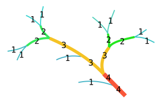
In mathematics, the Strahler number or Horton–Strahler number of a mathematical tree is a numerical measure of its branching complexity.
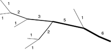
Arthur Newell Strahler was a geoscience professor at Columbia University who in 1952 developed the Strahler Stream Order system for classifying streams according to the power of their tributaries.
Little Massabesic Brook and Sucker Brook form a 1.9-mile-long (3.1 km) stream located in southern New Hampshire in the United States. They are tributaries of Massabesic Lake, part of the Merrimack River and Gulf of Maine watersheds. Despite the streams' short length, they are subject to the New Hampshire Comprehensive Shoreland Protection Act, because of their fourth-order stream status.

An hydrological transport model is a mathematical model used to simulate the flow of rivers, streams, groundwater movement or drainage front displacement, and calculate water quality parameters. These models generally came into use in the 1960s and 1970s when demand for numerical forecasting of water quality and drainage was driven by environmental legislation, and at a similar time widespread access to significant computer power became available. Much of the original model development took place in the United States and United Kingdom, but today these models are refined and used worldwide.

A perennial stream is a stream that has continuous flow of surface water throughout the year in at least parts of its catchment during seasons of normal rainfall, as opposed to one whose flow is intermittent. In the absence of irregular, prolonged or extreme drought, a perennial stream is a watercourse, or segment, element or emerging body of water which continually delivers groundwater. For example, an artificial disruption of stream, variability in flow or stream selection associated with the activity in hydropower installations, do not affect this status. Perennial streams do not include stagnant water, reservoirs, cutoff lakes and ponds that persist throughout the year. All other streams, or parts of them, should be considered seasonal rivers or lakes. The stream can cycle from intermittent to perpetual through multiple iterations.
Integrated Land and Water Information System (ILWIS) is a geographic information system (GIS) and remote sensing software for both vector and raster processing. Its features include digitizing, editing, analysis and display of data, and production of quality maps. ILWIS was initially developed and distributed by ITC Enschede in the Netherlands for use by its researchers and students. Since 1 July 2007, it has been released as free software under the terms of the GPL-2.0-only license. Having been used by many students, teachers and researchers for more than two decades, ILWIS is one of the most user-friendly integrated vector and raster software programmes currently available. ILWIS has some very powerful raster analysis modules, a high-precision and flexible vector and point digitizing module, a variety of very practical tools, as well as a great variety of user guides and training modules all available for downloading. The current version is ILWIS 3.8.6. Similar to the GRASS GIS in many respects, ILWIS is currently available natively only on Microsoft Windows. However, a Linux Wine manual has been released.

In hydrology, a mainstem is "the primary downstream segment of a river, as contrasted to its tributaries". Water enters the mainstem from the river's drainage basin, the land area through which the mainstem and its tributaries flow. A drainage basin may also be referred to as a watershed or catchment.

The Water of Feugh (pronounced:few-ikh) is a stream in Aberdeenshire that is the largest tributary to the River Dee. This stream rises in the Grampian Mountains of Scotland, in an area known as the Forest of Birse, and has a particularly scenic aspect in a series of cascades at the Bridge of Feugh slightly above its point of discharge to the Dee.
A hydrological code or hydrologic unit code is a sequence of numbers or letters that identify a hydrological unit or feature, such as a river, river reach, lake, or area like a drainage basin or catchment.

In geomorphology, drainage systems, also known as river systems, are the patterns formed by the streams, rivers, and lakes in a particular drainage basin. They are governed by the topography of land, whether a particular region is dominated by hard or soft rocks, and the gradient of the land. Geomorphologists and hydrologists often view streams as part of drainage basins. This is the topographic region from which a stream receives runoff, throughflow, and its saturated equivalent, groundwater flow. The number, size, and shape of the drainage basins varies and the larger and more detailed the topographic map, the more information is available.

A stream is a continuous body of surface water flowing within the bed and banks of a channel. Depending on its location or certain characteristics, a stream may be referred to by a variety of local or regional names. Long, large streams are usually called rivers, while smaller, less voluminous and more intermittent streams are known as streamlets, brooks or creeks.
The Pfafstetter Coding System is a hierarchical method of hydrologically coding river basins. It was developed by the Brazilian engineer Otto Pfafstetter in 1989. It is designed such that topological information is embedded in the code, which makes it easy to determine whether an event in one river basin will affect another by direct examination of their codes.