
Carshalton is a town, with a historic village centre, in south London, England, within the London Borough of Sutton. It is situated 9.5 miles (15.3 km) south-southwest of Charing Cross, in the valley of the River Wandle, one of the sources of which is Carshalton Ponds in the middle of the village. Prior to the creation of Greater London in 1965, Carshalton was in the administrative county of Surrey.
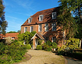
Cheam is a suburb of London, England, 10.9 miles (17.5 km) south-west of Charing Cross. It is divided into North Cheam, Cheam Village and South Cheam. Cheam Village contains the listed buildings Lumley Chapel and the 16th-century Whitehall. It is adjacent to two large parks, Nonsuch Park and Cheam Park. Nonsuch Park contains the listed Nonsuch Mansion. Parts of Cheam Park and Cheam Village are in a conservation area. Cheam is bordered by Worcester Park to the north-west, Morden to the north-east, Sutton to the east, Epsom, Ewell and Stoneleigh to the west and Banstead and Belmont to the south.

Wallington is a town in the London Borough of Sutton, South London, England, 9.7 miles (15.6 km) south-west of Charing Cross. Before the Municipal Borough of Beddington and Wallington merged into the London Borough of Sutton in Greater London in 1965, it was part of the county of Surrey. Wallington is a post town in the SM postcode area.

The London Borough of Sutton is a London borough in south-west London, England and forms part of Outer London. It covers an area of 43 km2 (17 sq mi) and is the 80th largest local authority in England by population. It borders the London Borough of Croydon to the east, the London Borough of Merton to the north and the Royal Borough of Kingston upon Thames to the north-west; it also borders the Surrey boroughs of Epsom and Ewell and Reigate and Banstead to the west and south respectively. The local authority is Sutton London Borough Council. Its principal town is the eponymous Sutton.
Paul Kenneth Burstow is a British former politician who served as the Liberal Democrat Member of Parliament for Sutton and Cheam for 18 years, from 1997 to 2015, when he was defeated by Paul Scully.
Sutton is the principal town in the London Borough of Sutton in South London, England. It lies on the lower slopes of the North Downs, and is the administrative headquarters of the Outer London borough. It is 10 miles (16 km) south-south west of Charing Cross, and is one of the thirteen metropolitan centres in the London Plan. The population of the town was counted as 41,483 in the 2011 census, while the borough overall counted 204,525.

Worcester Park is a suburban town in South West London, England. It lies in the London boroughs of Sutton and Kingston, and partly in the Surrey borough of Epsom and Ewell. The area is 10.1 miles (16.3 km) southwest of Charing Cross. The suburb's population was 16,031 at the time of the 2001 census. The suburb comprises the Worcester Park ward, an electoral area of the London Borough of Sutton with a population in 2011 of 11,655, as well as the Cuddington ward, an electoral area of Epsom and Ewell, which had a population of 5,791 at the time of the 2001 census.

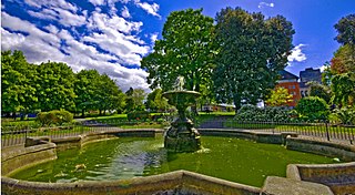
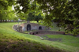
The London Borough of Sutton, one of the peripheral London boroughs, has 89 parks and open spaces within its boundaries, a total area of 1500 acres (6 km2). Varied in size and layout, green spaces range from the compact Manor Park in Sutton town centre, through the medium-sized Grove Park, which forms part of the Carshalton Village conservation area, to the large and historic Oaks Park in the south of the borough. In the west of the borough is the large Nonsuch Park. The main parks are:

London Buses route X26 is a Transport for London contracted bus route in London, England. Running between Heathrow Airport and West Croydon bus stations, it is operated by London General. It is the longest bus route currently operating in London, covering a distance of 23.75 miles, albeit with limited stops.

The A232 is a major road running west–east across South London, which connects the A24 in Ewell, Surrey with the A224 Orpington bypass. It passes through the major South London towns of Sutton and Croydon.

Sutton and Cheam was a local government district in north east Surrey, England from 1882 to 1965.
Carshalton Park is a public park in Carshalton, in the London Borough of Sutton. It is situated south of the High Street, in the area bounded by Ruskin Road, Ashcombe Road, Woodstock Road and The Park. Carshalton Park and some of the surrounding houses, are within a conservation area.
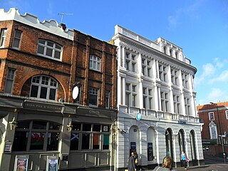
Sutton High Street is a high street running north–south through the town of Sutton in the London Borough of Sutton.

The Sutton Heritage Mosaic is a large mural in the form of a mosaic situated in Sutton High Street in the town of Sutton in Greater London, England. One of the largest examples of wall art in Britain, it was commissioned by the London Borough of Sutton to celebrate the borough's heritage.
The Sutton Twin towns mural is a large mural in the form of seven individual paintings situated in Sutton High Street in the town of Sutton in Greater London, England. It is one of six works of public art in Sutton town centre.
Manor Park is a public park in the town of Sutton in Greater London. It was created in 1914 on a site in the town centre, opposite the police station. Its grounds include the Sutton War Memorial, which was added in 1921. It is bounded by Throwley Way to the west; Carshalton Road to the south; Manor Park Road to the east, and Greyhound Road to the north. Sutton High Street runs parallel to Throwley Way, fifty yards to the west.

There are four conservation areas within the town of Sutton. One of these is in Sutton town centre - the Sutton Town Centre High Street Crossroads Conservation Area - while the other three are residential: Grove Avenue, Landseer Road and the Sutton Garden Suburb.

Elliot Haydn George Colburn is a British Conservative Party politician. He has been the Member of Parliament (MP) for Carshalton and Wallington since the 2019 general election. Colburn also served as councillor for the Cheam ward on Sutton Council from 2018 to 2022.

The Cock sign is situated on the crossroads of Sutton High Street and Carshalton Road in the London Borough of Sutton. Built in 1907, it was originally a pub sign for The Cock hotel and pub, before being converted into a road sign and lamp post. Since 2018, The Cock sign has been a Grade II listed structure.
The 2022 Sutton London Borough Council election took place on 5 May 2022. All 55 members of Sutton London Borough Council were elected. The elections took place alongside local elections in the other London boroughs and elections to local authorities across the United Kingdom.

