
Crail is a former royal burgh, parish and community council area in the East Neuk of Fife, Scotland.
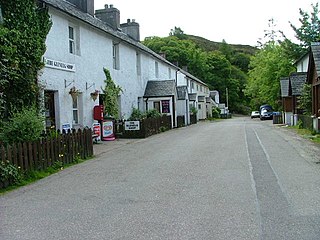
Glenelg is a scattered community area and civil parish in the Lochalsh area of Highland in western Scotland. Despite the local government reorganisation the area is considered by many still to be in Inverness-shire, the boundary with Ross-shire being at the top of Mam Ratagan the single-track road entry into Glenelg.
Balerno is a village on the outskirts of Edinburgh, Scotland situated 8 miles south-west of the city centre, next to Currie and then Juniper Green. Traditionally in the county of Midlothian it now administratively falls within the jurisdiction of the City of Edinburgh Council. The village lies at the confluence of the Water of Leith and the Bavelaw Burn. In the 18th and 19th century, the area was home to several mills using waterpower. In the 20th century, the mills closed and the village now forms a residential suburb of Edinburgh.

Carnwath is a moorland village on the southern edge of the Pentland Hills of South Lanarkshire, Scotland. The village lies about 30 mi (50 km) south of both Edinburgh and Glasgow. It is bounded by the North Medwyn and South Medwyn watercourses.
Currie is a village and suburb on the outskirts of Edinburgh, Scotland, situated 7 miles south west of the city centre. Formerly within the County of Midlothian, it now falls within the jurisdiction of the City of Edinburgh Council. It is situated between Juniper Green to the northeast and Balerno to the southwest. It gives its name to a civil parish.

East Saltoun and West Saltoun are separate villages in East Lothian, Scotland, about 5 miles south-west of Haddington and 20 miles east of Edinburgh.

Torphichen is a historic small village located north of Bathgate in West Lothian, Scotland. The village is approximately 18 miles (29 km) west of Edinburgh, 7 miles (11 km) south-east of Falkirk and 4 miles (6.4 km) south-west of Linlithgow. The village had a population of 570 in the and a population of 710 in 2016. Torphichen's placename may be Gaelic in origin, e.g., "Tóir Féichín", Tor Fithichean, or partly from Brythonic "tre fychan" or small hill.

Longside is a village located in Aberdeenshire, Scotland, consisting of a single main street. It lies seven miles inland from Peterhead and two miles from Mintlaw on the A950. Its population in 2001 was 721. The River Ugie flows through it.
Sorbie is a small village in Wigtownshire, Machars, within the Administration area of Dumfries and Galloway Council, Scotland.
Longforgan is a village and parish in the Carse of Gowrie, in Perth and Kinross, Scotland. It lies 5 miles west of Dundee on the main A90 road.

Auchenblae is a village in the Kincardine and Mearns area of Aberdeenshire, formerly in Kincardineshire, Scotland. The village was known for its weavers, a whisky distillery and the annual Paldie's Fair horse market.

Ecclesmachan (NT058736) is an historic village in West Lothian. It lies just north of Uphall on the B8046 road and just south of Threemiletown. The village is notable for its medieval origin parish church. As at 2001, the population of the civil parish of Ecclesmachan was 529 and was 811 in 1991.
Minto is a village and parish in the Scottish Borders area of Scotland in Roxburghshire county. It is located 6 miles north-east of Hawick, north of the River Teviot.
Bowden is a village in the Roxburghshire area of the Scottish Borders, situated 3 miles south of Melrose, 2 miles west of Newtown St Boswells and tucked in the shadow of the Eildon Hills, Scotland.
Fogo is a village in the county of Berwickshire, in the Borders of Scotland, 3 miles south of Duns, on the Blackadder Water.

Edrom is a parish and small village in the pre-1975 ancient county of Berwickshire, now an administrative area of the Scottish Borders region of Scotland.
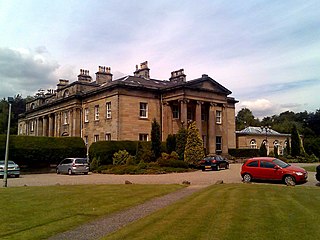
Balbirnie House is an early 19th-century country house in Glenrothes, in central Fife, Scotland. The present house was completed in 1817 as a rebuild of an 18th-century building, itself a replacement for a 17th-century dwelling. The home of the Balfour family from 1640, the house was sold in 1969 and opened as a hotel in 1990. The grounds now comprise a large public park and a golf course. The house is protected as a category A listed building, while the grounds are included in the Inventory of Gardens and Designed Landscapes in Scotland.

The Glen, also known as Glen House, is an estate and country house in the parish of Traquair, southern Scotland. It is located in the glen of the Quair Water, around 5 kilometres (3 mi) south-west of Innerleithen, and 9 kilometres (5.6 mi) south-east of Peebles, in the Scottish Borders. The estate is recorded from the 13th century, but the present Glen House was built in the mid 19th century. The house is protected as a category A listed building, and the grounds are included in the Inventory of Gardens and Designed Landscapes in Scotland, the national listing of significant gardens. Besides the house, the Temple, stables, and the "Lion Gate" are also category A listed.
Glass is a parish about 8 miles west of Huntly, Aberdeenshire, Scotland. It is now wholly located in Aberdeenshire but before the reorganisation of Scottish county boundaries in 1891 it was partly in Banffshire. The name Glass may have come from the Gaelic word for "grey," "meadow" or "stream."

Skirling is a parish, community council area and village in Peeblesshire in the Scottish Borders situated 2+1⁄2 miles east of Biggar in Lanarkshire. Biggar Water, a tributary the River Tweed forms the southern boundary of the parish with the parish of Broughton, Glenholm and Kilbucho. It is also bounded by that parish on the east, namely the Broughton part of it. On the north it is bounded by the parish Kirkurd in Peeblesshire. Spittal Burn forms most of its western boundary with Lanarkshire.


