Toledo Executive Airport

Last updated
Toledo Executive Airport
Toledo Executive Airport, January 2022.jpg
Summary
Airport typePublic
Owner Toledo–Lucas County Port Authority
Serves Toledo, Ohio
Location Wood County, Ohio
Elevation  AMSL 623 ft / 190 m
Coordinates 41°33′53″N083°28′56″W / 41.56472°N 83.48222°W / 41.56472; -83.48222
Website https://toledoexecutiveairport.com/
Map
USA Ohio relief location map.svg
Airplane silhouette.svg
TDZ
Usa edcp relief location map.png
Airplane silhouette.svg
TDZ
Runways
Direction LengthSurface
ftm
4/223,7991,158 Asphalt
14/325,8291,777Asphalt
Statistics (2021)
Aircraft operations90,700
Based aircraft44

Toledo Executive Airport( IATA : TDZ, ICAO : KTDZ, FAA LID : TDZ) is seven miles southeast of Toledo, in Wood County, Ohio. It is an FAA designated reliever to Toledo Express Airport (TOL), Toledo's primary airport. [1] Toledo Executive Airport was renamed from Metcalf Field in 2010. [2]

Contents

History

The airport began as a grand dream on June 22, 1927 with the establishment of The Toledo Airport Committee. $257,000 were raised in early 1928 to fund the airport in 33 1/2 hours, which is the time it took Charles Lindbergh to fly from New York City to Paris. Six hundred and twenty shares of stock were sold to 620 Toledo citizens. [3]

A site was chosen based on proximity to an air route from Chicago to New York, and land was purchased in the spring of 1928. [3] On June 3, 1928, "The Transcontinental Airport of Toledo, Incorporated" was dedicated to a large crowd. The dream was soon realized, as the airport set records for air mail and became the second largest airport east of the Rocky Mountains.

The airport received a complete weather station, and the US Weather Bureau of Toledo operated at the airport until early 1955. [3]

National Air Transport began service with passenger and air mail flights to Chicago and Cleveland, and a national record amount of mail was carried through the airport in 1929. [3]

By 1931, National and three other airlines had merged becoming United Airlines, and Toledo had become a stop on a transcontinental air route extending from San Francisco to New York.

The boom period did not last. Inadequate construction began to crumble, driving away business. The Great Depression hit. However, President Franklin D Roosevelt allocated $216,077 in Works Progress Administration funds for upgrades to the airport in 1936. The city of Toledo provided $52,000 in matching funds. These funds provided three paved runways. [3]

The airport was purchased by the City of Toledo soon after. In 1937, it airport became a Class One port and the second largest airfield east of the Rocky Mountains. [3]

United Airlines paused service in 1938 when the airport's runways began to buckle, leaving the airport unused. Federal grants were provided in 1940 to rebuild the runways, and the airport reopened in 1941. [4] [5]

A terminal building and Air Traffic Control tower were built in 1948. Funds were provided by the City of Toledo and the federal government. [3]

Ultimately, neighboring developments prevented the airport from expanding its runways to meet the needs of increasingly larger commercial aircraft. When the larger Toledo Express Airport was built in 1954, Toledo Executive became redundant, and it was ultimately abandoned. [3]

The field languished for over a decade, used for things such as fireworks displays and drag racing. General Aviation and business jets in the late 1960s and early 1970s brought the field back into use as an airport; private, business and charter flights continue to be the main activities. [3] [4]

In 1966, Executive Aviation signed a fifteen-year lease and invested $250,000 in a new main hangar, 20 T-hangars, and a fuel facility. [3] Astro Aviation took over operations at the airport in 1970, and Crow Executive Air was founded in 1974. [6]

In 1975, the airport was put under the control of the Toledo–Lucas County Port Authority. [3] In 1977, it was renamed in honor of Tommy Metcalf, Toledo's second commissioner of aviation. [7]

In April 2007, a FedEx Boeing 727 landed at the airport to be decommissioned and provided to Owens Community College for ground-based training. [8] The airport's name was changed to Toledo Executive Airport in 2010. [9]

On June 5, 2010, an EF4 tornado passed along the south edge of the airport. Neighboring Lake High School and other structures were severely affected. [10]

Early Nearby Airports

Notable Visitors

Facilities and aircraft

Facilities

Toledo Executive Airport covers 450 acres (180 ha) and has two asphalt runways: 4/22 is 3,799 x 75 ft (1,158 x 23 m) and 14/32 is 5,829 x 100 ft (1,777 x 30 m). Air America Aviation Services provides fixed-base operations.

Blue Horizons Flying Club operates from the field;

EAA Chapter 582 is on the field.

Air America Aerial Ads, LLC, operates from the field;

Aircraft

In the year ending July 29, 2021, the airport had 90,700 aircraft operations, average 248 per day: 78% general aviation, 22% air taxi, and <1% military. [11]

As of July 2021, there were 44 aircraft based at the airport: 36 single-engine and 6 multi-engine airplanes, 1 jet, and 1 glider. [12]

Accidents and incidents

See also

Related Research Articles

<span class="mw-page-title-main">John Glenn Columbus International Airport</span> Airport serving Columbus, Ohio, United States

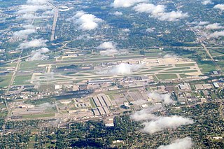
John Glenn Columbus International Airport is an international airport located 6 miles east of downtown Columbus, Ohio. Formerly known as Port Columbus International Airport, it is managed by the Columbus Regional Airport Authority, which also oversees operations at Rickenbacker International Airport and Bolton Field. The airport code "CMH" stands for "Columbus Municipal Hangar," the original name of the airport.

<span class="mw-page-title-main">Bolton Field</span> Airport

Bolton Field is a public airport in Columbus, Franklin County, Ohio, United States. It is a towered airport operated under the Columbus Regional Airport Authority. It is one of 12 general aviation reliever airports in Ohio recognized in the National Plan of Integrated Airport Systems (NPIAS) and is a reliever airport for John Glenn Columbus International Airport.

<span class="mw-page-title-main">Kalamazoo/Battle Creek International Airport</span> Airport in Michigan, US

Kalamazoo/Battle Creek International Airport is a county-owned public airport in Kalamazoo, Kalamazoo County, Michigan, US, 3 miles (4.8 km) southeast of Downtown Kalamazoo. The airport is located approximately 20 miles (32 km) west of the city of Battle Creek. It is included in the Federal Aviation Administration (FAA) National Plan of Integrated Airport Systems for 2023-27, in which it is categorized as a non-hub primary commercial service facility.

<span class="mw-page-title-main">Akron–Canton Airport</span> Airport in Green, Ohio, United States

Akron–Canton Airport is a commercial airport in the city of Green, in southern Summit County, Ohio. The airport is located about 14 miles (23 km) southeast of Akron and 10 miles (16 km) northwest of Canton. It is jointly operated by Summit County and Stark County. The airport is a "reliever" airport for Northeast Ohio and markets itself as "A better way to go", emphasizing the ease of travel in comparison to Cleveland Hopkins International Airport. Just under 90% of its traffic is general aviation. It is included in the Federal Aviation Administration (FAA) National Plan of Integrated Airport Systems for 2019–2023, in which it is categorized as a small-hub primary commercial service facility.

Charles B. Wheeler Downtown Airport is a city-owned, public-use airport serving Kansas City, Missouri, United States. Located in Clay County, this facility is included in the National Plan of Integrated Airport Systems, which categorized it as a general aviation reliever airport.

<span class="mw-page-title-main">Republic Airport</span> Airport in East Farmingdale, New York

Republic Airport is a regional airport in East Farmingdale, New York, located one mile east of Farmingdale village limits.

<span class="mw-page-title-main">Erie International Airport</span> Airport in Erie County, Pennsylvania, United States

Erie International Airport Tom Ridge Field is a public airport five miles (8.0 km) southwest of Erie, in Erie County, Pennsylvania, United States. Airline service at Erie faces stiff competition from the Pittsburgh, Cleveland, Buffalo, and Toronto airports, all within three hours of Erie by car. In 2004, Erie was the third-fastest-growing airport in the United States, and the fastest-growing airport in Pennsylvania. It is 128 miles (206 km) from Pittsburgh, 111 miles (179 km) from the Canada–U.S. border, 95 miles (153 km) from Cleveland, Ohio and 105 miles (169 km) from Buffalo, New York.

<span class="mw-page-title-main">Akron Executive Airport</span> Airport

Akron Fulton Intl Airport is in Akron, Summit County, Ohio, United States. It is owned by the City of Akron; FAA's National Plan of Integrated Airport Systems for 2011–2015 called it a general aviation airport.

<span class="mw-page-title-main">Jackson County Airport (Michigan)</span> Airport

Jackson County Airport, also known as Reynolds Field, is a county-owned, public-use airport located two nautical miles (3.7 km) west of the central business district of Jackson, in Jackson County, Michigan, United States. It is a class D airport with operating control tower. It is included in the Federal Aviation Administration (FAA) National Plan of Integrated Airport Systems for 2017–2021, in which it is categorized as a regional general aviation facility.

Taos Regional Airport is a public use airport eight nautical miles (15 km) northwest of the central business district of Taos, in Taos County, New Mexico, United States. It is owned by the Town of Taos. FAA's National Plan of Integrated Airport Systems for 2009–2013 classifies it as a general aviation airport.

<span class="mw-page-title-main">Fresno Chandler Executive Airport</span> Airport

Fresno Chandler Executive Airport is a public use airport 1.5 miles west of the central business district of Fresno, California, United States. It is owned by the City of Fresno and managed by the city’s Airports Division.

<span class="mw-page-title-main">Ohio State University Airport</span> Airport in Columbus, United States of America

Ohio State University Airport is a public airport six miles (10 km) northwest of downtown Columbus, in Franklin County, Ohio, United States. It is owned and operated by Ohio State University in Columbus. It is also known as the OSU Don Scott Airport, named after Donald E. Scott, an OSU alumnus who died during his training as a pilot in the United Kingdom during World War II. The airport's main entrance is located on Case Road, and is easily accessible from OH-315 and Interstate 270.

<span class="mw-page-title-main">Mansfield Lahm Regional Airport</span> Airport in Mansfield, Ohio

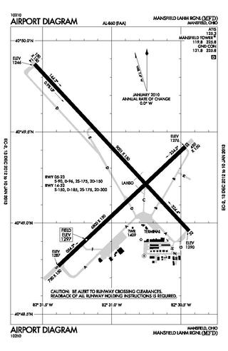
Mansfield Lahm Regional Airport is three miles (5 km) north of Mansfield, in Richland County, Ohio. By car the airport is an hour away from Cleveland and Columbus, near Interstate I-71, US Rt 30, State Route 13.

<span class="mw-page-title-main">Springfield–Beckley Municipal Airport</span> Airport in Ohio, United States of America

Springfield–Beckley Municipal Airport is a civil-military airport five miles (8 km) south of Springfield, in Clark County, Ohio, United States. It is owned by the city of Springfield. It is named after the Beckley family, a member of which knew the Wright Brothers, and witnessed and photographed their first flights.

<span class="mw-page-title-main">Montgomery-Gibbs Executive Airport</span> Airport in San Diego, California

Montgomery-Gibbs Executive Airport, formerly known as Montgomery Field and Gibbs Field, is a public airport in San Diego, California, United States, six miles (10 km) north of downtown San Diego. The airport covers 456 acres (185 ha) and has three runways, one public helipad, and two private helipads. The runways are 28R/10L and 28L/10R (parallel) and 5/23.

Lawrence County Airpark is a public use airport located two nautical miles (3.7 km) west of the central business district of Chesapeake, a village in Lawrence County, Ohio, United States. It is publicly owned by Lawrence County Board of Commissioners. The airport lies across the Ohio River from Huntington, West Virginia.

Fairfield County Airport is a public use airport in Fairfield County, Ohio, United States. It is located three nautical miles (6 km) northwest of the central business district of Lancaster, the county seat. The airport is owned by the Fairfield County Commissioners.

Galion Municipal Airport is three miles northeast of Galion in Crawford County, Ohio. The FAA's National Plan of Integrated Airport Systems for 2009–2013 classified it as a general aviation airport.

<span class="mw-page-title-main">Marion Municipal Airport (Ohio)</span> Public use airport in Marion, Ohio

Marion Municipal Airport is three miles northeast of Marion, in Marion County, Ohio. The FAA's National Plan of Integrated Airport Systems for 2011–2015 categorized it as a general aviation facility.

The Youngstown Elser Metro Airport is a privately owned, public use general aviation airport located 7 miles southwest of Youngstown in Beaver Township, Mahoning County, Ohio, United States. It has a 10/28 asphalt runway of 4,012 ft × 50 ft in dimension.

References

  1. 1 2 FAA Airport Form 5010 for TDZ PDF , effective 2023-08-10.
  2. Call it Toledo Executive Airport Archived 2011-09-30 at the Wayback Machine
  3. 1 2 3 4 5 6 7 8 9 10 11 12 13 14 15 16 17 18 19 20 21 22 Welling, Alwin F. (1998). "Metcalf Field". In Meadows, Cathy J. (ed.). A History of Lake Township Wood County, Ohio. Ada, Ohio: The Ada Herald. pp. 255–270.
  4. 1 2 A brief history of Toledo Executive Airport
  5. Reopening of Airport is Real Achievement for Toledo
  6. Ohio Secretary of State
  7. Process Begins for Renaming Metcalf Field>
  8. FedEx Delivers Gift Plane to Owens
  9. Call It Toledo Executive Airport
  10. June 5, 2010 Tornado Touchdown: Wood & Ottawa Counties >
  11. KTDZ at AirNav
  12. KTDZ at SkyVector
  13. "Skistmas George Pietnpol Aircamper crash in Ohio (N6186L) | PlaneCrashMap.com". planecrashmap.com. Retrieved 2024-04-30.
  14. "Loss of control Accident Pietenpol Air Camper N23RT,". Aviation Safety Network. Flight Safety Foundation. Retrieved 2024-04-30.
  15. Injuries Possible When Ultralight Crashes at Toledo Executive Airport Archived 2013-01-23 at archive.today