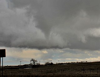
A tornado is a violently rotating column of air that is in contact with both the surface of the Earth and a cumulonimbus cloud or, in rare cases, the base of a cumulus cloud. It is often referred to as a twister, whirlwind or cyclone, although the word cyclone is used in meteorology to name a weather system with a low-pressure area in the center around which, from an observer looking down toward the surface of the Earth, winds blow counterclockwise in the Northern Hemisphere and clockwise in the Southern. Tornadoes come in many shapes and sizes, and they are often visible in the form of a condensation funnel originating from the base of a cumulonimbus cloud, with a cloud of rotating debris and dust beneath it. Most tornadoes have wind speeds less than 180 kilometers per hour, are about 80 meters across, and travel several kilometers before dissipating. The most extreme tornadoes can attain wind speeds of more than 480 kilometers per hour (300 mph), are more than 3 kilometers (2 mi) in diameter, and stay on the ground for more than 100 km (62 mi).

A mesocyclone is a meso-gamma mesoscale region of rotation (vortex), typically around 2 to 6 mi in diameter, most often noticed on radar within thunderstorms. In the northern hemisphere it is usually located in the right rear flank of a supercell, or often on the eastern, or leading, flank of a high-precipitation variety of supercell. The area overlaid by a mesocyclone’s circulation may be several miles (km) wide, but substantially larger than any tornado that may develop within it, and it is within mesocyclones that intense tornadoes form.

NEXRAD or Nexrad is a network of 159 high-resolution S-band Doppler weather radars operated by the National Weather Service (NWS), an agency of the National Oceanic and Atmospheric Administration (NOAA) within the United States Department of Commerce, the Federal Aviation Administration (FAA) within the Department of Transportation, and the U.S. Air Force within the Department of Defense. Its technical name is WSR-88D.

Weather radar, also called weather surveillance radar (WSR) and Doppler weather radar, is a type of radar used to locate precipitation, calculate its motion, and estimate its type. Modern weather radars are mostly pulse-Doppler radars, capable of detecting the motion of rain droplets in addition to the intensity of the precipitation. Both types of data can be analyzed to determine the structure of storms and their potential to cause severe weather.

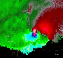
A hook echo is a pendant or hook-shaped weather radar signature as part of some supercell thunderstorms. It is found in the lower portions of a storm as air and precipitation flow into a mesocyclone, resulting in a curved feature of reflectivity. The echo is produced by rain, hail, or even debris being wrapped around the supercell. It is one of the classic hallmarks of tornado-producing supercells. The National Weather Service may consider the presence of a hook echo coinciding with a tornado vortex signature as sufficient to justify issuing a tornado warning.
The National Severe Storms Laboratory (NSSL) is a National Oceanic and Atmospheric Administration (NOAA) weather research laboratory under the Office of Oceanic and Atmospheric Research. It is one of seven NOAA Research Laboratories (RLs).

The bounded weak echo region, also known as a BWER or a vault, is a radar signature within a thunderstorm characterized by a local minimum in radar reflectivity at low levels which extends upward into, and is surrounded by, higher reflectivities aloft, forming a kind of dome of weak echoes. This feature is associated with a strong updraft and is almost always found in the inflow region of a thunderstorm: it cannot be seen visually. The BWER has been noted on radar imagery of severe thunderstorms since 1973 and has a lightning detection system equivalent known as a lightning hole.
Volumetric Imaging and Processing of Integrated Radar, known by the acronym VIPIR, is an analysis and display program for Doppler weather radar, created and sold by Baron Services. This software allows improved analysis of radar data for private users, in particular television stations, similar to the Weather Decision Support System program used by the National Weather Service.
Tornadogenesis is the process by which a tornado forms. There are many types of tornadoes and these vary in methods of formation. Despite ongoing scientific study and high-profile research projects such as VORTEX, tornadogenesis is a volatile process and the intricacies of many of the mechanisms of tornado formation are still poorly understood.
Convective storm detection is the meteorological observation, and short-term prediction, of deep moist convection (DMC). DMC describes atmospheric conditions producing single or clusters of large vertical extension clouds ranging from cumulus congestus to cumulonimbus, the latter producing thunderstorms associated with lightning and thunder. Those two types of clouds can produce severe weather at the surface and aloft.

The Verification of the Origins of Rotation in Tornadoes Experiment are field experiments that study tornadoes. VORTEX1 was the first time scientists completely researched the entire evolution of a tornado with an array of instrumentation, enabling a greater understanding of the processes involved with tornadogenesis. A violent tornado near Union City, Oklahoma was documented in its entirety by chasers of the Tornado Intercept Project (TIP) in 1973. Their visual observations led to advancement in understanding of tornado structure and life cycles.

GRLevelX is a suite of data processing and display programs developed by Gibson Ridge Software, LLC (GRS), to view weather radar data. It went on the market in March 2005. It comes in three versions, all of which ingest raw data: GRLevel2 and GRLevel2 Analyst Edition for viewing Level II data of the National Weather Service (NWS), and GRLevel3 for viewing Level III data. All programs are capable of rendering dual polarization data.
Terminal Doppler Weather Radar (TDWR) is a Doppler weather radar system with a three-dimensional "pencil beam" used primarily for the detection of hazardous wind shear conditions, precipitation, and winds aloft on and near major airports situated in climates with great exposure to thunderstorms in the United States. As of 2011, all were in-service with 45 operational radars, some covering multiple airports in major metropolitan locations, across the United States & Puerto Rico. Several similar weather radars have also been sold to other countries such as China (Hong Kong). Funded by the United States Federal Aviation Administration (FAA), TDWR technology was developed in the early 1990s at Lincoln Laboratory, part of the Massachusetts Institute of Technology, to assist air traffic controllers by providing real-time wind shear detection and high-resolution precipitation data.
A mesovortex is a small-scale rotational feature found in a convective storm, such as a quasi-linear convective system, a supercell, or the eyewall of a tropical cyclone. Mesovortices range in diameter from tens of miles to a mile or less and can be immensely intense.

A tornadic debris signature (TDS), often colloquially referred to as a debris ball, is an area of high reflectivity on weather radar caused by debris lofting into the air, usually associated with a tornado. A TDS may also be indicated by dual-polarization radar products, designated as a polarimetric tornado debris signature (PTDS). Polarimetric radar can discern meteorological and nonmeteorological hydrometeors and the co-location of a PTDS with the enhanced reflectivity of a debris ball are used by meteorologists as confirmation that a tornado is occurring.
Leslie R. Lemon was an American meteorologist bridging research and forecasting with expertise in weather radar, particularly regarding severe convective storms. Lemon was, along with Charles A. Doswell III, a seminal contributor to the modern conception of the supercell convective storm which was first identified by Keith Browning, and he developed the Lemon technique to estimate updraft strength and thunderstorm organization also as a continuation of Browning's work.
The following is a glossary of tornado terms. It includes scientific as well as selected informal terminology.

Donald W. Burgess is an American meteorologist who has made important contributions to understanding of severe convective storms, particularly tornadoes, radar observations and techniques, as well as to training other meteorologists. He was a radar operator during the first organized storm chasing expeditions by the University of Oklahoma (OU) in the early 1970s and participated in both the VORTEX projects.

Multiple Elevation Scan Option for Supplemental Adaptive Intra-Volume Low-Level Scan, is a dynamic scanning option for the WSR-88D, controllable by the operator of the radar, when in VCP mode 12 and 212, and additionally 35 and 215 with the Build 18 update scheduled for October 2017. When active, anywhere from one to three supplemental low-level scans can be added to any volume, increasing overall low-level data availability and improves general severe weather detection, as needed. When active, per the National Weather Service, low-level updates will be available "every 75 to 90 seconds".
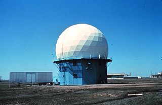
NOAA's 10 cm Doppler Weather Radar was a 10 cm wavelength S-band Doppler Weather Radar commonly referred to as NSSL Doppler, and was used to track severe weather and related meteorological phenomena. The radar became operational soon after its donation, collecting its first data in May 1971. Data was collected on magnetic tapes and processed on a NASA computer post event due to the lack of real-time capability at the time.